Anaga Rural Park Trails - Journey Through the Enchanted Laurel Forest
The Anaga Rural Park Trails offer a profound journey into one of Europe’s most ancient and ecologically significant landscapes. Located on the northeastern tip of Tenerife in the Canary Islands, the Macizo de Anaga is a rugged mountain range defined by sharp peaks, deep ravines, and the largest remaining expanse of prehistoric laurel forest (Laurisilva) in the world. This 15-kilometre circuit is not merely a walk; it is a passage through a "living fossil" ecosystem that has remained largely unchanged for over seven million years. As a UNESCO Biosphere Reserve, the park serves as a sanctuary for hundreds of endemic species of flora and fauna, many of which exist nowhere else on Earth. The trail weaves through mist-shrouded ridges where the trade winds (Alisios) create a unique microclimate, transforming the landscape into a lush, emerald-green labyrinth of moss-draped trees and giant ferns. For the modern hiker, Anaga represents a stark and beautiful contrast to the arid, volcanic landscapes typically associated with the southern reaches of Tenerife, offering a temperate, humid, and deeply atmospheric wilderness experience.
- Distance: 15.0 km loop
- Duration: 4-6 hours
- Difficulty: Moderate (due to steep gradients and potentially slippery terrain)
- Highest point: Cruz del Carmen (920 m)
- Elevation Gain: 750 m
- Closest City: San Cristóbal de La Laguna
- Trailhead: Cruz del Carmen Visitor Centre
- Permits: No permits required for this specific route (though some restricted areas in the park require advance booking)
Overview
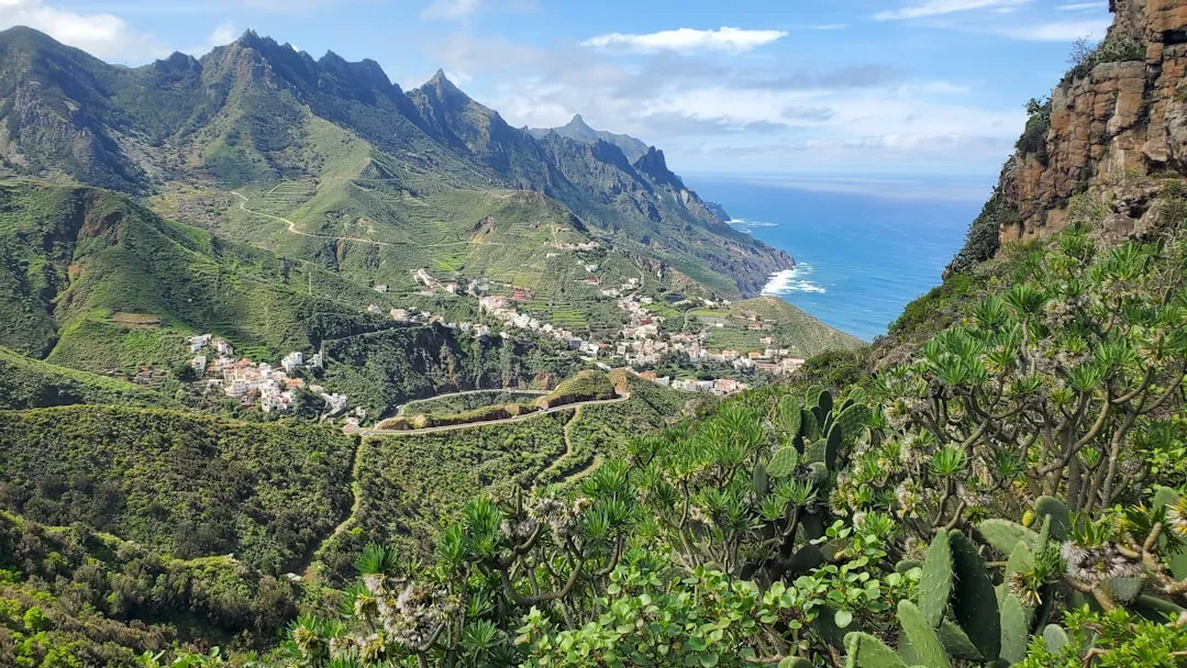
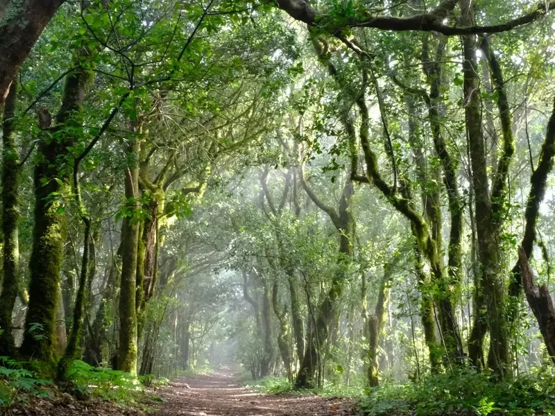
The Anaga Rural Park is a geological masterpiece, formed by a series of volcanic eruptions between seven and nine million years ago. Unlike the younger, more central parts of Tenerife dominated by Mount Teide, Anaga has been sculpted by millions of years of erosion, resulting in the dramatic "roques" (volcanic plugs) and "barrancos" (deep ravines) that define its skyline. The trail network here is extensive, but the 15-kilometre loop starting from Cruz del Carmen provides the most comprehensive introduction to the park’s diverse environments. The experience is characterised by the "mar de nubes" (sea of clouds), a phenomenon where the moisture-laden trade winds are trapped against the northern slopes, creating a persistent mist that feeds the ancient forest through horizontal rain. This constant humidity allows the Laurisilva—a type of cloud forest that covered much of the Mediterranean basin during the Tertiary period—to thrive in a subtropical sanctuary.
Walking through Anaga is a sensory experience. The air is cool and heavy with the scent of damp earth and laurel leaves. The canopy is so dense in sections that sunlight only reaches the forest floor in dappled patches, illuminating vibrant green mosses and lichens that cling to every available surface. As the trail moves out of the dense forest and onto the exposed ridges, the views open up to reveal the Atlantic Ocean crashing against the jagged coastline hundreds of metres below. You will pass through remote "caseríos" (hamlets) like Chinamada, where residents still live in traditional cave houses carved directly into the volcanic rock. This blend of natural prehistoric beauty and unique cultural heritage makes Anaga one of the most rewarding hiking destinations in the Macaronesian archipelago.
The terrain is varied and demands respect. While the paths are generally well-maintained, the combination of steep ascents, descents over basaltic rock, and the frequent presence of mud requires a steady foot and appropriate footwear. The route is a masterclass in ecological transition, moving from the high-altitude cloud forest down to the thermophilic scrublands and back again, providing hikers with a vertical cross-section of Tenerife’s incredible biodiversity. Whether you are a dedicated botanist, a photography enthusiast, or simply a walker seeking solitude, the Anaga Rural Park Trails deliver a sense of isolation and timelessness that is increasingly rare in modern Europe.
History and Cultural Context
The history of Anaga is as layered as its volcanic strata. Long before the Spanish conquest of the Canary Islands in the late 15th century, the Macizo de Anaga was one of the nine "menceyatos" (kingdoms) of the Guanches, the indigenous Berber-descended inhabitants of Tenerife. The Guanches of Anaga were known for their resilience, living in the natural caves provided by the volcanic landscape and herding goats across the treacherous ridges. Many of the trails used by modern hikers today follow the "caminos reales" (royal paths) originally established by the Guanches and later expanded by Spanish settlers to transport goods between isolated coastal villages and the inland markets of La Laguna.
For centuries, Anaga remained one of the most isolated parts of the island. Until the mid-20th century, many villages were only accessible by sea or by arduous footpaths. This isolation preserved a unique way of life. The "Camino de las Lecheras" (The Milkmaids' Path), for example, was the route taken by women from the Anaga villages who travelled daily to La Laguna to sell fresh milk, carrying heavy containers on their heads across the mountains. The architecture of the region also reflects this history of adaptation; in places like Chinamada, the "casas cueva" (cave houses) provided natural insulation against both the summer heat and the damp winter mists, a tradition that continues to this day.
In 1987, the area was officially protected as a Natural Park, and in 1994, it was reclassified as a Rural Park to recognise the importance of the traditional agricultural practices that coexist with the wilderness. The UNESCO Biosphere Reserve designation in 2015 further cemented its status as a global treasure. Today, the park is a symbol of Canary Island identity, representing a successful balance between environmental conservation and the preservation of a rural heritage that has survived against the odds of geography and time.
Want more background? Read extended notes on history and cultural context → Learn more
Seasonal Highlights and Weather Reality
Anaga is a land of microclimates, and the weather can change dramatically within a single kilometre. The most important factor is the "Alisios" (trade winds), which blow from the northeast. These winds bring the moisture that sustains the forest, but they also mean that the ridges are frequently shrouded in thick fog, even when the southern beaches of Tenerife are basking in sunshine. Temperatures in the park are generally 5-10 degrees Celsius cooler than at sea level.
Spring (March to May): This is arguably the best time to visit. The forest is at its most vibrant, and the wildflowers, including the endemic Anaga cineraria and various species of orchids, are in full bloom. The temperatures are mild, making the steep climbs more manageable, and the clarity of the air often provides the best views of the coastline.
Autumn (September to November): Another excellent window for hiking. The summer heat has dissipated, and the heavy winter rains have not yet arrived. The forest takes on a deep, rich green hue, and the light is particularly beautiful for photography, especially in the late afternoon when the sun sits low over the Atlantic.
Winter (December to February): Winter brings the highest rainfall. While the forest is spectacular when dripping with water, the trails can become extremely muddy and slippery. Snow is rare but not unheard of on the highest peaks. Hikers should be prepared for wind and rain, and visibility can be very low on the ridges. However, this is also the time when the waterfalls in the deeper ravines are most active.
Summer (June to August): While the rest of Tenerife can be scorching, Anaga remains relatively cool due to the canopy and the mist. However, the "Calima"—a weather phenomenon where hot, dust-laden air blows over from the Sahara—can occasionally raise temperatures and reduce visibility. On clear summer days, the sun is intense, and the lack of shade on the ridge sections of the trail can be challenging.
Recommended Itinerary
Anaga Rural Park: The Chinamada Loop
Phase 1: Cruz del Carmen to Batán de Abajo
- Distance: 4 km
- Elevation change: 400 m descent
- Time: 1.5 hours
- Start at the Cruz del Carmen Visitor Centre, following the signs for PR-TF 10.
- Enter the "Sendero de los Sentidos" (Path of the Senses) briefly before branching off into the deep Laurisilva forest.
- The trail descends steeply through a tunnel of ancient laurel and heather trees.
- Pass through the hamlet of Batán de Arriba, noting the traditional terraced agriculture.
- Continue down to Batán de Abajo, a small village nestled in a fertile valley where vines and potatoes are still grown on steep slopes.
Phase 2: Batán de Abajo to Chinamada
- Distance: 3.5 km
- Elevation change: 350 m ascent
- Time: 1.5 hours
- The trail crosses the bottom of the ravine and begins a steady climb along the eastern wall.
- The vegetation shifts from dense forest to more open scrubland, offering views of the "Roque de los Pinos."
- The path is carved into the volcanic rock in sections, providing dramatic perspectives of the Barranco del Tomadero.
- Arrive at Chinamada, a unique settlement where approximately 30 cave houses are still inhabited.
- Take a short detour to the "Mirador de Aguaide" for a breathtaking 500-metre vertical view down to the Atlantic Ocean.
Phase 3: Chinamada to Las Carboneras
- Distance: 2.5 km
- Elevation change: 100 m ascent
- Time: 45 minutes
- Follow the trail towards Las Carboneras, walking along a high ridge that separates two major ravines.
- This section is relatively flat compared to the previous stages and offers panoramic views of the central Anaga massif.
- Pass through small orchards and gardens where locals maintain traditional crops.
- Arrive in Las Carboneras, a picturesque village with a small plaza and a church, perfect for a short rest.
Phase 4: Las Carboneras to Cruz del Carmen
- Distance: 5 km
- Elevation change: 300 m ascent
- Time: 1.5 - 2 hours
- The final leg of the journey climbs back into the heart of the laurel forest.
- The trail follows the "Camino del Monte," an old supply route that winds through some of the oldest trees in the park.
- Expect mist and cooler temperatures as you regain altitude.
- The path eventually levels out as it approaches the Cruz del Carmen Visitor Centre.
- Finish the loop back at the trailhead, where you can visit the exhibition centre to learn more about the flora you have just seen.
Important Notes:
- The trail is well-marked with yellow and white paint (PR - Pequeño Recorrido), but a map or GPS is recommended.
- The descent to Batán and the ascent to Chinamada are the most physically demanding sections.
- The Mirador de Aguaide is a mandatory side trip for the views, but use caution near the edges.
- Public buses (guaguas) serve Cruz del Carmen frequently from La Laguna, making this an easy route to access without a car.
Planning and Bookings
Book Your Trip
Everything you need to plan your journey
Accommodation
Find places to stay near San Cristóbal de La Laguna
Flights
Search flights to San Cristóbal de La Laguna
Essential Preparation
Planning a hike in Anaga requires more than just checking the distance. The primary challenge is the weather variability. Even if it is sunny in San Cristóbal de La Laguna or Santa Cruz, Cruz del Carmen may be shrouded in thick, cold mist. Hikers should check the AEMET (Spanish Meteorological Agency) mountain forecast specifically for the Anaga region. Fitness requirements are moderate; while the distance is 15 km, the 750 metres of elevation gain involves several steep, sustained climbs that require a good level of cardiovascular health and leg strength.
The logistical hub for Anaga is the city of San Cristóbal de La Laguna, a UNESCO World Heritage site. It is highly recommended to base yourself here. The city offers a range of services, from outdoor gear shops to supermarkets for supplies. Access to the trailhead at Cruz del Carmen is straightforward via the TITSA bus network (lines 076, 077, or 273). If driving, arrive at Cruz del Carmen before 10:00 AM, as the parking lot is small and fills up quickly with tourists visiting the viewpoint.
Trail Accommodation
This specific 15 km route is designed as a day hike, and there is no overnight accommodation directly on the trail itself. Camping is strictly prohibited within the Anaga Rural Park to protect the fragile ecosystem. However, for those wishing to spend multiple days exploring the wider trail network, there are several options in the surrounding area.
Albergue de Anaga (Montes de Anaga Hostel): Located in El Bailadero, about 15 minutes by car or bus from Cruz del Carmen. This is a modern, clean hostel offering both dormitory beds and private rooms. It provides a great base for hikers, with a cafeteria and stunning views over both sides of the ridge. Booking in advance is essential, especially on weekends.
Rural Houses (Casas Rurales): In villages like Taganana, Afur, and Las Carboneras, several traditional houses have been converted into holiday rentals. these offer a more immersive experience but usually require a minimum stay of 2-3 nights.
San Cristóbal de La Laguna: Most hikers choose to stay in the city, which offers everything from budget hostels to boutique hotels in historic buildings. The commute to the park is only 20-30 minutes.
Required Gear
- Hiking boots - Essential. The terrain is rocky, often wet, and slippery. Ankle support and a deep tread pattern are non-negotiable.
- Waterproof jacket - Even in summer, the mist in the laurel forest can be soaking. A lightweight, breathable shell is required.
- Layered clothing - Use a moisture-wicking base layer and a fleece mid-layer. Temperatures drop significantly in the shade of the forest.
- Navigation - A physical map of Anaga (available at the visitor centre) or a reliable offline GPS app (like AllTrails or Komoot). Mobile signal is intermittent in the deep ravines.
- Trekking poles - Highly recommended for the steep descents into Batán and the climb to Chinamada to save your knees and provide stability on mud.
- Small backpack - 20-30L with a rain cover.
What to Bring
- Water - Minimum 2 litres per person. There are very few reliable water sources on the trail, although you can buy bottled water in the villages of Batán or Las Carboneras.
- Food - High-energy snacks (nuts, dried fruit) and a substantial lunch. While there are small bars in Chinamada and Las Carboneras, their opening hours can be unpredictable.
- Sun protection - SPF 50+ sunscreen, sunglasses, and a hat. The sun is deceptively strong on the exposed ridge sections, even when it feels cool.
- First aid kit - Include blister plasters (Compeed), antiseptic wipes, and any personal medications.
- Mobile phone - Fully charged, with the emergency number (112) saved. A power bank is a wise addition.
- Identification and Cash - Small denominations of Euros for the bus or for a coffee in the village bars, as many do not accept cards.
Permits
For the majority of the trails in Anaga Rural Park, including the 15 km loop described here, no permits are required. You are free to hike the PR-TF routes at your own pace. However, there is one notable exception within the park that hikers should be aware of: the "El Pijaral" Integral Natural Reserve, also known as the Enchanted Forest.
El Pijaral Restricted Access:
- Because of its extreme ecological sensitivity, access to the El Pijaral trail is limited to 45 people per day.
- Permits are free but must be booked online through the Cabildo de Tenerife website well in advance (often 2-3 months ahead for weekends).
- If you plan to deviate from the main loop to visit this specific area, you must carry a digital or printed copy of your permit and your ID, as rangers do patrol the area and fines for unauthorised entry are significant.
General Regulations:
- While no permit is needed for the Chinamada loop, you must stay on the marked trails. Venturing off-path is prohibited to prevent erosion and protect endemic flora.
- Organised groups of more than 20 people may require prior notification to the park office.
- Commercial filming or professional photography requires a specific permit from the Cabildo.
Logistics and Transport:
- Bus (Guagua): TITSA lines 076 and 077 run from La Laguna to Cruz del Carmen. The fare is approximately €1.50 each way (cheaper with a Ten+ card).
- Taxi: A taxi from La Laguna to Cruz del Carmen costs approximately €15-€20.
- Parking: The car park at Cruz del Carmen is free but very busy. If it is full, do not park on the road verges, as this obstructs emergency vehicles and will result in a fine.
Other Activities in the Area
The Anaga peninsula offers a wealth of experiences beyond the hiking trails. Consider these options to round out your visit:
- San Cristóbal de La Laguna: Spend an evening exploring this colonial gem. Its grid-like streets served as the model for many Latin American cities. Visit the Cathedral, the local markets, and enjoy the vibrant tapas scene.
- Playa de las Teresitas: Located near the village of San Andrés, this is Tenerife's most famous golden sand beach. The sand was imported from the Sahara, and the calm waters are perfect for a post-hike swim.
- Taganana and Benijo: Drive down the winding road to the coast to visit Taganana, one of the oldest villages on the island. Continue to Benijo beach for what is widely considered the most spectacular sunset in Tenerife, with dramatic sea stacks rising from the Atlantic.
- Surfing at Almáciga: The northern coast of Anaga is a hotspot for surfing. Several schools in the area offer lessons for those looking to experience the power of the Atlantic waves.
- Wine Tasting: The Tacoronte-Acentejo wine region borders Anaga. Visit a local "guachinche" (traditional family-run eatery) to try local wines and authentic Canarian dishes like "papas arrugadas" (wrinkled potatoes) with mojo sauce.
Safety and Conditions
Pre-Departure Checks:
- Check the weather forecast on AEMET.es. Pay close attention to wind alerts and heavy rain warnings.
- Ensure your phone is fully charged. While signal is decent on the ridges, it disappears in the deep ravines.
- Inform someone of your planned route and expected return time.
- Check the TITSA bus schedule for your return journey, as services become less frequent in the late afternoon.
Terrain Hazards: The volcanic rock in Anaga can be deceptively slippery, especially when covered in a thin layer of pine needles or damp moss. The descents are often steep and can be taxing on the joints. Watch out for "loose scree" on the more exposed sections near Chinamada. In the forest, be mindful of low-hanging branches and exposed roots that can be trip hazards in low-visibility mist.
The "Mar de Nubes" (Sea of Clouds): While beautiful, the mist can cause sudden drops in temperature and significantly reduce visibility. If you find yourself in thick fog, stay on the marked path. The yellow and white PR markings are usually placed on rocks or trees at regular intervals. If you haven't seen a marker for 100 metres, retrace your steps to the last known point.
Flash Floods: During periods of exceptionally heavy rain, the "barrancos" (ravines) can experience flash flooding. If heavy rain is forecast, avoid trails that involve crossing ravine floors, such as the section between Batán and Chinamada.
Emergency Services: In the event of an accident, dial 112. This is the universal emergency number in Spain and can be reached even if your provider has no signal, provided another network is available. Be prepared to give your coordinates or describe your location based on the nearest trail marker or landmark.
Side Trips and Points of Interest
Mirador de Aguaide: Located just a 10-minute walk from the centre of Chinamada, this viewpoint is the highlight of the northern coast. It offers a sheer drop of over 500 metres to the ocean below. From here, you can see the coastal hamlets of Almáciga and the distant lighthouse of Punta de Anaga. It is a perfect spot for a lunch break, but there are no railings, so exercise extreme caution.
The Cave Houses of Chinamada: Take the time to walk through the village. These are not museum pieces; they are active homes. The volcanic tuff is easy to carve but structurally sound, providing a constant temperature of around 18-20 degrees Celsius year-round. Respect the privacy of the residents while admiring the unique chimneys and colourful doors protruding from the hillsides.
Roque de los Pinos: A dramatic volcanic plug that hosts a rare stand of Canary Island Pines in an area otherwise dominated by laurel forest. It is a testament to the geological and botanical diversity of the park. The trail passes near its base, offering excellent photographic opportunities.
Sendero de los Sentidos: If you have extra time at the start or end of your hike at Cruz del Carmen, this short, accessible trail offers three different lengths. It is designed to engage your senses—smell the damp laurel, touch the ancient bark, and listen to the endemic birds like the Bolle’s Pigeon. It is an excellent "warm-up" for the main hike.
Batán de Abajo Laundry: In the village of Batán, you can still see the old stone communal laundry areas where women used to gather to wash clothes using the water from the mountain springs. It is a small but poignant reminder of the rural life that defined this region for centuries.
Leave No Trace
The Anaga Rural Park is a fragile sanctuary. The Laurisilva forest is a relic of a bygone era, and its survival depends on the responsible behaviour of every visitor. The ecosystem is highly sensitive to human impact, and even small actions can have long-lasting consequences.
Your responsibility as a walker:
- Pack out all rubbish. This includes organic waste like banana skins or apple cores, which do not belong in this specific ecosystem and can take a long time to decompose in the cool, damp climate.
- Stay strictly on the marked trails. The soil in the laurel forest is loose and prone to erosion; shortcuts create "social trails" that damage root systems and lead to landslides.
- Do not pick flowers or plants. Many species in Anaga are critically endangered and protected by law.
- Respect the silence. Avoid loud music or shouting. The park is home to rare bird species that are easily disturbed during nesting seasons.
- Do not stack rocks or create "cairns." This disturbs the micro-habitats of insects and small reptiles.
- Use public toilets at the visitor centres or in the villages. If you must go on the trail, ensure you are at least 50 metres from any water source and bury waste deeply, taking all paper with you.
- Respect private property in the hamlets. The terraced fields are the livelihood of the local people; do not enter them or pick fruit from the trees.
By following these principles, you help ensure that the "Enchanted Forest" remains enchanted for the next seven million years. Leave only footprints, take only photographs.