USA — Springdale, Utah
Wade through the Virgin River on this iconic 25.7km hike in Zion National Park, USA. This moderate, 8-12 hour route immerses you in a spectacular sandstone gorge, with towering walls reaching 600 metres. Expect to be waist-deep in cool water for much of this unique canyon walk, a truly unforgettable geological adventure.
Distance: 25.7 km
Elevation Gain: 152 m
Difficulty: Moderate
Duration: 8-12 hours
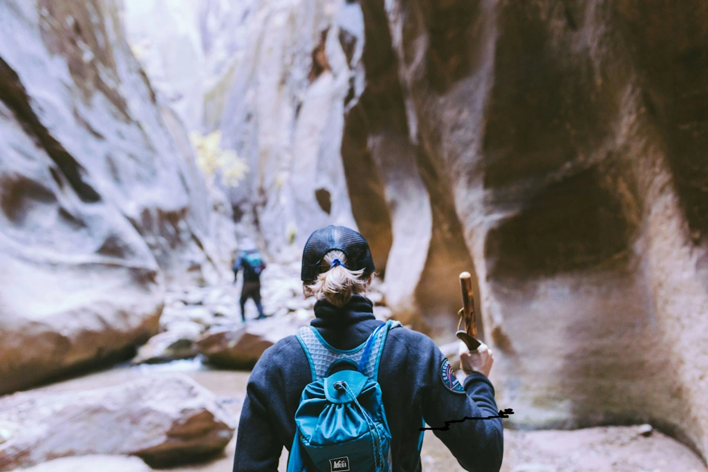
The Zion Narrows is not merely a hike; it is a profound immersion into the geological heart of the American Southwest. Located within the towering red rock cathedrals of Zion National Park in Utah, this 25.7-kilometre journey follows the Virgin River as it carves a narrow, serpentine path through Navajo Sandstone walls that soar up to 600 metres above the riverbed. Unlike traditional trails, the river is the path. For over sixty per cent of the journey, walkers are waist-deep in cool, flowing water, navigating a labyrinth of polished stone, hidden grottos, and hanging gardens. It is a landscape of staggering verticality and intimate detail, where the play of light on canyon walls creates a shifting kaleidoscope of orange, crimson, and gold. This is a world defined by the relentless power of water and the slow, patient work of erosion—a place where the scale of nature humbles the human spirit and every bend in the river reveals a new masterpiece of natural architecture.
The Zion Narrows is widely considered the premier slot canyon experience on Earth. While many slot canyons are dry and claustrophobic, the Narrows is a grand, aqueous corridor where the North Fork of the Virgin River serves as both the architect and the guide. The journey described here—the 25.7-kilometre Top-Down route—begins at the high-altitude plateau of Chamberlain's Ranch and descends through a progressively narrowing gorge until it reaches the iconic Temple of Sinawava in the main Zion Canyon. This route offers a complete transition from a wide, pastoral valley into the deepest, most dramatic sections of the canyon, including the world-famous "Wall Street" section, where the canyon narrows to just 6 to 9 metres wide while the walls rise vertically for hundreds of metres.
Walking the Narrows is a sensory experience unlike any other. The sound of the river is a constant companion, ranging from a gentle babble in the shallows to a thunderous roar in the tighter narrows. The air temperature drops significantly as you enter the deep shade of the canyon, providing a welcome respite from the scorching Utah sun, though it introduces the risk of hypothermia even in mid-summer. The terrain is notoriously challenging; the riverbed is covered in "bowling ball" rocks—slippery, unstable stones that require constant focus and the support of a sturdy walking staff. You are not just walking; you are balancing, wading, and occasionally swimming through a dynamic environment that changes with every seasonal flood.
The Narrows is also a sanctuary for unique flora and fauna. Hanging gardens of maidenhair ferns and scarlet monkeyflowers cling to the weeping walls where spring water seeps through the porous sandstone. In the quieter reaches, you may spot the American Dipper, a small bird that dives into the rushing water to feed, or the Zion snail, a species found nowhere else on the planet. This is a landscape that demands respect and preparation. The threat of flash floods is a literal matter of life and death, and the physical toll of walking 25 kilometres in moving water should not be underestimated. However, for those who come prepared, the Narrows offers a connection to the raw power of the natural world that is impossible to find anywhere else.
The human history of the Zion Narrows is as layered as the sandstone walls themselves. For thousands of years, the Virgin River valley has been a site of human habitation and spiritual significance. The Ancestral Puebloans (formerly known as the Anasazi) and the Fremont people occupied the wider Zion area from approximately 300 BC to 1300 AD. They utilised the river for irrigation, growing maize, squash, and beans on the fertile floodplains. Evidence of their presence remains in the form of granaries and petroglyphs found in the higher alcoves of the canyon, though the Narrows itself was likely used more for hunting and gathering than permanent settlement due to its volatile flood cycles.
By the time European explorers arrived, the Southern Paiute people inhabited the region. They referred to the canyon as "Mukuntuweap," which is often translated as "straight canyon" or "place of the spirit." The Paiute held a deep reverence for the canyon, often avoiding staying within its walls after dark out of respect for the spirits they believed resided there. Their knowledge of the river's moods and the hidden springs was essential for survival in this arid landscape.
The modern name "Zion" was bestowed by Mormon pioneers who settled in the area in the 1860s. Isaac Behunin, one of the first settlers in the canyon, famously remarked that "a man can worship God among these cathedrals as well as in any man-made church—this is Zion." In 1872, the legendary explorer John Wesley Powell conducted the first formal survey of the Narrows, naming many of the landmarks we recognise today. Powell was struck by the "sublime" nature of the gorge, describing the walls as "shining with a lustre of their own."
Zion National Monument was established in 1909, later becoming Zion National Park in 1919. The Narrows quickly gained a reputation among early adventurers as one of the most spectacular natural wonders in the United States. Today, the park works closely with indigenous groups to ensure that the cultural heritage of the land is respected, even as it hosts hundreds of thousands of visitors each year. The Narrows remains a place of pilgrimage, a testament to the enduring power of the American wilderness.
Want more background? Read extended notes on history and cultural context → Learn more
The Zion Narrows is a seasonal trail, and its accessibility is dictated entirely by the Virgin River's flow rate and the risk of flash floods. Understanding the seasonal nuances is critical for a safe and enjoyable journey.
Spring (March to May): This is the most volatile season. As snow melts on the high plateaus of the Markagunt, the Virgin River swells. The Narrows is typically closed to all hikers when the flow rate exceeds 150 cubic feet per second (CFS). In many years, the trail remains closed well into May or even June. Even if open, the water is frigid (often below 10°C), and the current is powerful, making the hike extremely strenuous.
Summer (June to August): This is the peak season for the Narrows, but it comes with a significant caveat: Monsoon Season. From mid-July through August, afternoon thunderstorms are common. These storms can drop massive amounts of rain on the distant drainage basins, sending a wall of water, mud, and debris down the Narrows with almost no warning. Flash floods are lethal. Hikers must check the flash flood potential forecast daily. On the positive side, the water temperature rises to a more comfortable 15–18°C, and the shade of the canyon provides relief from the 40°C heat of the main valley.
Autumn (September to October): Many experienced hikers consider this the "Golden Window." The monsoon risk decreases, the water levels are typically low and stable, and the autumn colours of the cottonwood trees provide a stunning contrast against the red walls. The air begins to cool, and the water temperature starts to drop, requiring more robust thermal protection (neoprene socks and dry pants) toward the end of October.
Winter (November to February): The Narrows is a different world in winter. It is a realm of ice and silence. Hiking during this time requires full dry suits, as the water is near freezing and the air temperature in the canyon rarely rises above 5°C. Only highly experienced and well-equipped hikers should attempt the Narrows in winter. The risk of hypothermia is extreme, but the reward is a level of solitude that is impossible to find during the rest of the year.
Early Morning: The High Plateau
Morning: The Upper Narrows
Midday: The Confluence and Deep Creek
Afternoon: Wall Street and The Temple
Important Notes:
The Zion Narrows is a logistically demanding hike that requires careful coordination. If you are attempting the Top-Down route, you must secure a permit, arrange a private shuttle to the trailhead, and ensure you have the correct gear. Fitness is a major factor; walking 25 kilometres on uneven, slippery rocks while fighting a current is equivalent to walking 40 kilometres on a flat trail. You should have strong ankles, good balance, and a solid cardiovascular base.
Springdale, Utah, is the gateway to Zion. It is a well-equipped town with numerous gear rental shops, hotels, and restaurants. Most hikers stay in Springdale the night before their trek. The Zion Canyon Shuttle system is free and efficient, but it only runs within the main canyon. To reach the Top-Down trailhead at Chamberlain's Ranch, you must book a private shuttle through one of the local outfitters (e.g., Zion Adventure Company or Zion Guru).
This is primarily a day hike for those with high fitness levels, requiring no overnight accommodation within the canyon. However, for those who wish to experience the Narrows at a slower pace, overnight permits are available for 12 designated campsites located between Deep Creek and Big Springs.
Campsite Facilities:
What's NOT Provided:
Booking Requirements:
Permits are mandatory for all Top-Down hikers (both day hikers and overnight campers). They are not required for Bottom-Up hikers who stay below Big Springs. The permit system is designed to limit impact on the fragile canyon environment and ensure hiker safety.
Permit Types and Strategy:
Permit Costs:
Important: You must pick up your permit in person at the Zion Wilderness Desk. They will provide a mandatory safety briefing, including the latest flash flood potential and river flow rates. If the flow rate is above 150 CFS, no permits will be issued and existing permits will be cancelled.


Precisely traced GPX for the Zion Narrows, ready for your GPS or favourite mapping app.
Zion National Park offers a wealth of other world-class experiences to complement your Narrows trek:
Flash Floods: The Primary Threat
Flash floods are the single greatest danger in the Narrows. A flash flood is a wall of water, often 3 to 10 metres high, carrying boulders, logs, and debris. They can occur even when the sky above you is blue, as storms 50 kilometres away can drain into the Narrows. If a flash flood occurs while you are in the Narrows, your chances of survival are near zero.
Hypothermia: Even in summer, the water is cold and the canyon is shaded. Wet clothing and wind can lead to hypothermia. Wear synthetic or wool layers (never cotton) and consider a neoprene top or dry suit in the shoulder seasons.
Cyanobacteria (Toxic Algae): In recent years, the Virgin River has experienced blooms of toxic cyanobacteria. These toxins can be absorbed through the skin or ingested. Do not submerge your head, do not drink the river water (even if filtered), and keep an eye on children and pets. Check the current health advisories at the trailhead.
Foot and Ankle Injuries: The "bowling ball" rocks are notorious for causing twisted ankles and broken toes. Wear sturdy, high-top canyoneering boots and use a walking staff at all times. Never hike the Narrows in sandals or flimsy trainers.
Falling Rocks: The canyon walls are dynamic. Spontaneous rockfalls occur. Avoid lingering directly under overhanging cliffs or loose-looking sections of the wall.
Orderville Canyon: Located about 4 kilometres from the end of the hike, this is the most significant side canyon. It is narrower and more technical than the main Narrows. You can explore a few hundred metres up-canyon without technical gear to see "Veiled Falls," a beautiful moss-covered cascade. Note that you cannot exit the Narrows via Orderville without a separate permit.
Big Springs: This is the turnaround point for Bottom-Up hikers and a major landmark for Top-Downers. Massive amounts of crystal-clear water gush directly from the canyon wall, creating a lush oasis of ferns and moss. It is the best place to refill water (though treatment is still advised).
Wall Street: The most famous 3-kilometre stretch of the canyon. Here, the river spans the entire width of the canyon floor, and the walls are so high and close together that direct sunlight rarely reaches the bottom. The acoustics here are haunting, and the scale is impossible to capture in a photograph.
Mystery Canyon Falls: Near the end of the hike, you will pass the exit of Mystery Canyon, where a waterfall often trickles down the wall. This is a popular spot for technical canyoneers to rappel into the Narrows.
The Zion Narrows is a fragile ecosystem under immense pressure from its own popularity. Because the river is the trail, everything you do affects the water quality downstream. Adhering to Leave No Trace principles is not optional; it is a requirement for the survival of this wilderness.
Specific Narrows Guidelines: