Zinal to Gruben: A Swiss Alpine Traverse
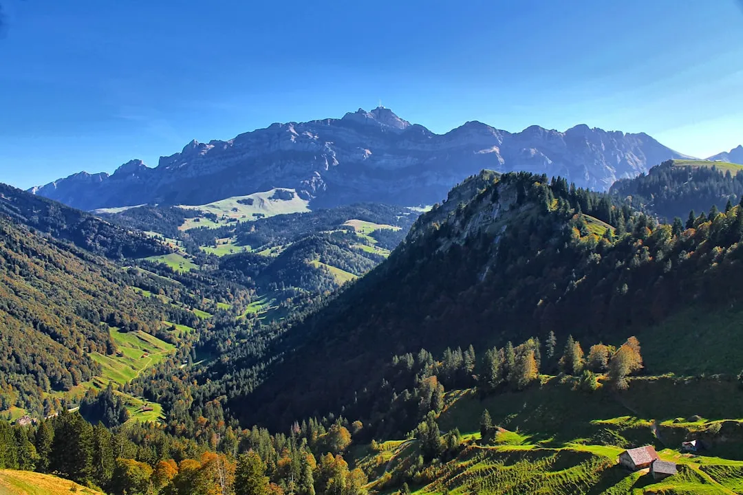
The Zinal to Gruben walk is a spectacular multi-day trek through the heart of the Swiss Alps, traversing the Val d'Anniviers and the Mattertal. This challenging route connects the charming alpine village of Zinal with the picturesque hamlet of Gruben, offering breathtaking vistas of iconic peaks like the Weisshorn, Zinalrothorn, and Bishorn. It's a journey that immerses walkers in dramatic glacial landscapes, high alpine meadows, and traditional Swiss mountain culture. The trail demands good fitness and sure-footedness, rewarding hikers with unparalleled panoramas and a profound sense of accomplishment. This is a true alpine adventure, suitable for experienced hikers seeking a classic European mountain experience.
- Distance: Approximately 63 km
- Duration: 5–7 days
- Season: Mid-July to late September
- Difficulty: Challenging
- Highest point: Approximately 3,000 metres
- Starting point: Zinal
- Ending point: Gruben
- Closest major town: Visp
Overview
The Zinal to Gruben traverse is a quintessential high-alpine trek, renowned for its dramatic scenery and demanding terrain. It is not a single, continuously marked path but rather a series of interconnected trails and high mountain passes that link the Val d'Anniviers with the Mattertal. The route typically begins in Zinal, a popular resort village nestled at the foot of the imposing Weisshorn. From Zinal, the trail ascends steeply, often via high mountain paths or passes, to reach remote mountain huts that serve as vital waypoints. These huts, perched at high altitudes, offer basic but essential accommodation and are gateways to some of the most spectacular alpine scenery in Switzerland.
The journey involves significant elevation gain and loss each day, with ascents often leading to rugged passes that offer panoramic views of the surrounding 4,000-metre peaks. Descending into the next valley, walkers are treated to a different perspective, often encountering lush alpine meadows dotted with wildflowers in summer, followed by descent into charming, traditional villages. The trail's character shifts from the grandeur of glaciers and snowfields to the pastoral beauty of the lower valleys. The final destination, Gruben, is a small, tranquil hamlet known for its traditional wooden houses and serene atmosphere, providing a peaceful conclusion to a demanding trek.
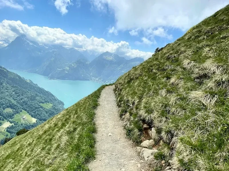
This route is best undertaken by those with solid hiking experience, comfortable with steep ascents, rocky terrain, and potentially exposed sections. The weather in the high Alps can change rapidly, so preparedness for all conditions is paramount. The Zinal to Gruben walk is an unforgettable experience for those who seek the raw beauty and challenge of the Swiss Alps.
History and Cultural Context
The Val d'Anniviers and the Mattertal have a long history of human habitation and transhumance, with communities relying on agriculture and pastoralism for centuries. The high passes that now form part of the Zinal to Gruben route were historically used by shepherds and traders to move livestock and goods between these valleys. The isolation of these valleys meant that distinct cultural traditions and dialects persisted for a long time.
The development of mountaineering in the 19th century transformed these remote valleys into destinations for intrepid explorers and climbers. Peaks like the Weisshorn, Zinalrothorn, and Bishorn, visible from the trail, were among the great challenges of the "Golden Age of Alpinism." The construction of mountain huts, often by local alpine clubs, facilitated access to these high-altitude regions, making them accessible to a wider range of hikers and climbers.
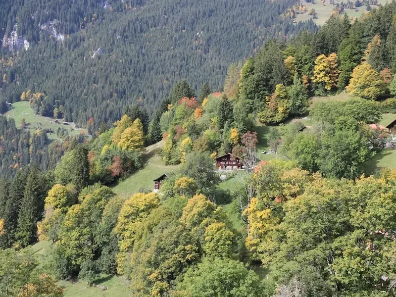
The villages along the route, such as Zinal and Gruben, have evolved from traditional farming communities into popular tourist destinations. However, they have largely retained their authentic charm. The architecture, with its characteristic wooden chalets, reflects centuries of adaptation to the alpine environment. The history of the region is deeply intertwined with the mountains themselves—a story of resilience, resourcefulness, and a profound connection to the natural world.
Seasonal Highlights and Weather Reality
The optimal season for hiking the Zinal to Gruben route is from mid-July to late September. During this period, the snow has generally melted from the higher passes, and the weather is typically more stable, although still unpredictable.
Mid-July to August: This is peak summer. Alpine meadows are in full bloom, offering vibrant displays of wildflowers. The days are long, providing ample daylight for hiking. However, this is also the busiest period, and mountain huts can be crowded. Afternoon thunderstorms are common, so starting hikes early in the morning is advisable.
September: The autumn colours begin to emerge in the lower valleys, creating a beautiful contrast with the rugged mountain scenery. The air is often crisp and clear, offering excellent visibility. The crowds thin out considerably, providing a more tranquil hiking experience. However, the days are shorter, and the first snowfalls can occur at higher elevations towards the end of the month.
Weather: The high Alps are known for their rapidly changing weather. Even in summer, hikers can encounter sunshine, rain, strong winds, fog, and even snow within a single day. Temperatures can fluctuate significantly, especially at higher altitudes. It is crucial to be prepared for all conditions, including cold temperatures, even during the summer months.
Recommended Itinerary
5-Day Zinal to Gruben Itinerary (Challenging)
Day 1: Zinal to Cabane du Petit Mountet
- Distance: Approximately 12 km
- Elevation gain: Approximately 1,200 m
- Time: 5–6 hours
- Start in Zinal (1,670 m)
- Ascend steeply through forests and alpine pastures
- Pass the hamlet of Mottec
- Continue towards the impressive Zinal Glacier
- Arrive at Cabane du Petit Mountet (2,138 m), a well-situated mountain hut with stunning views of the Grand Cornier and Zinalrothorn
- This day is a significant climb to acclimatise and gain altitude
Day 2: Cabane du Petit Mountet to Cabane de Tracuit
- Distance: Approximately 10 km
- Elevation gain: Approximately 1,000 m
- Time: 5–7 hours
- Cross the Zinal Glacier (requires glacier crossing experience or guide) or take a higher, more challenging route over the Col du Mont Durand (3,470 m)
- The route over Col du Mont Durand is demanding, with steep ascents and descents
- Spectacular views of the Weisshorn and surrounding peaks
- Arrive at Cabane de Tracuit (3,268 m), a high-altitude refuge offering incredible panoramas
- This is a demanding day, requiring good fitness and acclimatisation
Day 3: Cabane de Tracuit to Cabane de la Bella Tola
- Distance: Approximately 15 km
- Elevation gain: Approximately 600 m, Elevation loss: Approximately 1,000 m
- Time: 6–8 hours
- Descend from Cabane de Tracuit towards the Turtmanntal
- Cross the Turtmann Glacier (requires glacier crossing experience or guide) or take a higher route
- Ascend towards the Cabane de la Bella Tola (2,900 m)
- This day involves significant glacier travel and high alpine terrain
- The hut offers views towards the Mischabel group
Day 4: Cabane de la Bella Tola to Gruben
- Distance: Approximately 18 km
- Elevation gain: Approximately 400 m, Elevation loss: Approximately 1,500 m
- Time: 6–7 hours
- Descend from Cabane de la Bella Tola into the Turtmanntal
- Follow the valley floor for a section before ascending towards the Augstbord Pass (2,894 m)
- The Augstbord Pass offers a final spectacular vista before the descent
- Descend into the Mattertal towards the hamlet of Gruben (1,870 m)
- This day involves a long descent into the valley
Day 5: Gruben to Zinal (Optional Return or Extension)
- Distance: Approximately 15 km (return to Zinal)
- Elevation gain: Approximately 1,000 m
- Time: 5–6 hours
- Option to hike back to Zinal via the Augstbord Pass, or arrange transport from Gruben
- This return journey offers a different perspective on the landscape
Important Notes:
- This itinerary is a suggestion and can be adapted based on fitness, weather, and available time.
- Glacier crossings require appropriate equipment (crampons, ice axe, rope) and experience, or the hiring of a certified mountain guide.
- Hut bookings are essential, especially during peak season.
- The terrain is challenging, with steep ascents, descents, and potentially exposed sections.
- Always check weather forecasts and trail conditions before setting out each day.
Planning and Bookings
Book Your Trip
Everything you need to plan your journey
Accommodation
Find places to stay near Visp
Flights
Search flights to Visp
Essential Preparation
The Zinal to Gruben trek is a serious alpine undertaking. Thorough preparation is crucial. This includes assessing your fitness level, as the route involves significant daily elevation changes and long hiking hours. It is highly recommended to have prior experience with multi-day hiking in mountainous terrain, including navigating potentially challenging paths and dealing with variable weather conditions. Familiarity with using a map and compass, or a GPS device, is essential, as trail marking can vary.
Logistics involve reaching Zinal and arranging transport from Gruben. Zinal is accessible by public transport via Visp. From Gruben, transport options are more limited, often requiring pre-arranged taxis or buses that may run infrequently. It is advisable to book accommodation in Zinal before and after your trek, and to confirm transport arrangements from Gruben well in advance. Consider the need for a mountain guide, especially if you are not experienced with glacier travel or high alpine routes.
Trail Accommodation
The Zinal to Gruben route relies on a network of mountain huts (cabanes) operated by local alpine clubs or private entities. These huts provide basic accommodation, typically in dormitory-style rooms with bunk beds. Sleeping bags are mandatory, and often a hut liner is required.
Hut Facilities:
- Bunk beds with mattresses and pillows (sleeping bags/liners required)
- Communal dining areas
- Basic meals and drinks available for purchase (half-board often offered)
- Toilets (often pit toilets or basic flush systems)
- Limited washing facilities (cold water, no showers in most high-altitude huts)
- No electricity for charging devices in most remote huts
What Huts Don't Provide:
- Private rooms
- Hot showers (rare)
- Hair dryers or extensive toiletries
- Wi-Fi or mobile phone signal (highly unreliable)
- Food unless purchased
Booking Requirements:
- Reservations are essential, especially during the peak season (July-September).
- Book directly with the respective hut or through the Swiss Alpine Club (SAC) website if applicable.
- Hut fees vary but typically range from CHF 60-90 per person per night for non-members, with discounts for SAC members.
- Some huts may require a deposit.
Seasonal Availability: Huts are generally open from mid-June to mid-October, depending on snow conditions and management. Always verify opening dates directly with the hut operators.
Required Gear
- Sturdy, waterproof hiking boots with ankle support, well broken-in.
- Waterproof and windproof jacket and trousers (Gore-Tex or similar).
- Warm layers: fleece jacket, thermal base layers (merino wool or synthetic).
- Insulating jacket (down or synthetic fill) for evenings and cold conditions.
- Hat and gloves: warm beanie and waterproof gloves.
- Backpack (40-60 litres) with a rain cover.
- Sleeping bag (rated to at least 0°C comfort) and a hut liner.
- Head torch with spare batteries.
- First-aid kit including blister treatment, pain relievers, and personal medications.
- Sun protection: high SPF sunscreen, sunglasses, wide-brimmed hat.
- Navigation tools: map of the area, compass, and/or GPS device with pre-loaded routes.
- Trekking poles: highly recommended for steep ascents and descents.
- Water bottles or hydration reservoir (minimum 2 litres capacity).
- Personal locator beacon (PLB) or satellite messenger for emergencies.
What to Bring
- Food: Lunches and snacks for each day. Some huts offer half-board (dinner and breakfast), but it's wise to carry your own provisions.
- Water purification tablets or a filter, as water sources may not always be treated.
- Toiletries: biodegradable soap, toothbrush, toothpaste, small quick-drying towel.
- Camera and spare batteries/power bank.
- Cash (Swiss Francs): many huts do not accept credit cards.
- Small backpack for day trips or summit attempts from huts.
- Duct tape and cord for repairs.
- Book or journal for downtime in huts.
- Earplugs for sleeping in dormitories.
Permits
For the Zinal to Gruben trek, specific permits are generally not required for hiking the trails themselves. The routes traverse public land and national park areas where access is open to hikers. However, access to certain mountain huts may require advance booking, and in some cases, membership in an alpine club like the Swiss Alpine Club (SAC) can offer discounts and priority booking.
Hut Bookings:
- It is crucial to book accommodation in mountain huts well in advance, especially during the peak hiking season (July to September).
- Huts can fill up quickly, and last-minute availability is rare.
- Bookings can usually be made directly through the hut's website or via the Swiss Alpine Club (SAC) if the hut is affiliated.
- When booking, be prepared to provide your name, contact details, the dates of your stay, and the number of people in your party.
- Some huts may require a deposit to confirm your reservation.
Glacier Travel:
- If your chosen route involves glacier crossings (e.g., Zinal Glacier, Turtmann Glacier), you will need appropriate equipment (crampons, ice axe, rope) and experience.
- Alternatively, hiring a certified mountain guide is highly recommended for safe glacier travel. Guides are typically booked in advance through local guiding offices in Zinal or Täsch.
National Park Regulations: While no specific permits are needed for hiking, always adhere to local regulations regarding camping (generally not permitted outside designated areas), waste disposal, and respecting the natural environment. Information on specific park rules can usually be found at visitor centres or on the websites of the relevant cantons or national park authorities.
Other Activities in the Area
The regions surrounding Zinal and Gruben offer a wealth of activities for those looking to extend their stay or explore beyond the main trek:
- Mountaineering: The area is a paradise for climbers, with numerous peaks and challenging routes. Guided ascents of peaks like the Weisshorn or Zinalrothorn are popular.
- Via Ferrata: Several via ferrata routes are available in the Val d'Anniviers and Mattertal, offering a thrilling way to experience the mountains with fixed cables and ladders.
- Mountain Biking: Extensive networks of mountain bike trails exist, catering to various skill levels.
- Paragliding: For the adventurous, tandem paragliding flights offer incredible aerial views of the valleys and peaks.
- Exploring Villages: Wander through the charming villages of Zinal, Gruben, and others in the Val d'Anniviers and Mattertal, admiring the traditional architecture and local culture.
- Scenic Drives: The roads through the Val d'Anniviers offer stunning vistas and access to hiking trailheads.
- Photography: The dramatic alpine scenery provides endless opportunities for landscape photography.
Safety and Conditions
Weather: Alpine weather is notoriously unpredictable. Always check the latest mountain forecast (e.g., from MeteoSwiss or local tourist offices) before and during your trek. Be prepared for rapid changes, including sudden storms, fog, rain, and snow, even in summer. Hypothermia is a risk at higher altitudes.
Terrain: The Zinal to Gruben route involves challenging terrain, including steep ascents and descents, rocky paths, scree slopes, and potentially exposed sections. Good balance and sure-footedness are essential. Trekking poles can significantly aid stability and reduce strain on joints.
Glacier Travel: If your route includes glacier crossings, this is a serious undertaking. You must have the necessary equipment (crampons, ice axe, rope), knowledge of glacier travel techniques (crevasse rescue), and experience. If you lack these, hiring a certified mountain guide is strongly advised. Never attempt to cross a glacier alone or unprepared.
Altitude: The trek reaches significant altitudes, with some huts situated above 3,000 metres. Acclimatisation is important. Listen to your body, stay hydrated, and be aware of the symptoms of altitude sickness (headache, nausea, dizziness). If symptoms worsen, descend immediately.
Navigation: While trails are generally marked, visibility can be poor in fog or snow. Carry a detailed map and compass, and know how to use them. A GPS device or smartphone with offline maps is a valuable backup.
Emergency: Carry a fully charged mobile phone and a personal locator beacon (PLB) or satellite messenger for emergencies, as mobile signal is often unreliable in the mountains. Know the emergency numbers for Switzerland (144 for ambulance, 112 for general emergency). Inform someone of your itinerary and expected return time.
Hut Safety: Follow the rules and guidelines provided by hut wardens. Be mindful of other hikers, especially in dormitories. Ensure you have adequate lighting for navigating at night.
Side Trips and Points of Interest
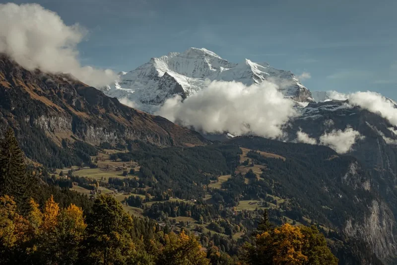
Weisshorn Views: The entire trek offers spectacular views of the majestic Weisshorn (4,506 m), one of the most beautiful mountains in the Alps. From Zinal, the hut approaches, and the high passes, the Weisshorn dominates the skyline, providing constant photographic opportunities.
Zinal Glacier and Grand Cornier: On the first day, the approach to Cabane du Petit Mountet offers close-up views of the Zinal Glacier and the imposing Grand Cornier (3,961 m). The scale of these glacial features is awe-inspiring.
Turtmann Glacier: The crossing of the Turtmann Glacier (if chosen) is a highlight for many, offering a true high-alpine experience. The surrounding peaks and the vast expanse of ice are unforgettable.
Augstbord Pass: This historic pass offers a final, sweeping panorama of the Mattertal valley and the surrounding peaks before the descent to Gruben. It's a fitting culmination of the high-alpine journey.
Traditional Villages: The villages of Zinal and Gruben themselves are points of interest, showcasing traditional Valais architecture and offering a glimpse into alpine life. Gruben, in particular, is a remarkably preserved hamlet.
Leave No Trace
The Zinal to Gruben trek traverses pristine alpine environments, including fragile meadows, sensitive glacial areas, and remote mountain ecosystems. Adhering to Leave No Trace principles is paramount to preserving these landscapes for future generations.
Plan Ahead and Prepare: Research your route thoroughly, understand the terrain, and be prepared for all weather conditions. Book accommodation in advance to avoid overcrowding and ensure you have a place to stay.
Travel and Camp on Durable Surfaces: Stick to marked trails to avoid damaging vegetation. If camping is permitted in designated areas, use established sites. In the high mountains, the trail itself is the most durable surface.
Dispose of Waste Properly: Pack out everything you pack in, including all food scraps, wrappers, and any other litter. Use designated toilets at huts. If no toilet facilities are available, dig catholes at least 60 metres away from water sources, trails, and campsites.
Leave What You Find: Do not remove rocks, plants, or any other natural objects. Respect cultural and historical sites.
Minimise Campfire Impacts: Campfires are generally not permitted in alpine environments due to the risk of wildfires and damage to vegetation. Use a portable stove for cooking.
Respect Wildlife: Observe wildlife from a distance and never feed animals. Feeding them can alter their natural behaviour and diet, and can be harmful to their health.
Be Considerate of Other Visitors: Keep noise levels down, especially in huts and on trails. Yield to other hikers when necessary. Respect the tranquility of the mountain environment.