Zillertal Alps High Route - The Berliner Höhenweg
The Zillertal Alps High Route, famously known as the Berliner Höhenweg, is one of the most prestigious and demanding high-altitude trekking circuits in the European Alps. Spanning approximately 150 kilometres and involving a staggering 12,000 metres of cumulative elevation gain, this journey traverses the heart of the High Alps Nature Park Zillertal Alps in Tyrol, Austria. Unlike many other alpine routes that cross glaciers, the Berliner Höhenweg remains primarily on solid rock and steep alpine meadows, though it skirts the edges of massive ice fields and provides constant, breathtaking views of 3,000-metre peaks. The route is a masterclass in Tyrolean mountain architecture, connecting a series of historic mountain huts—some of which are protected monuments—that have served as sanctuaries for mountaineers for over 140 years. This is not a journey for the faint-hearted; it requires physical stamina, absolute sure-footedness, and a deep respect for the volatile weather systems of the high mountains.
- Distance: 150.0 km (full circuit including approaches)
- Duration: 8–10 days
- Season: July to September (hut opening dates vary by snow conditions)
- Huts: Gamshütte, Friesenberghaus, Olpererhütte, Furtschaglhaus, Berliner Hütte, Greizer Hütte, Kasseler Hütte, Karl-von-Edel-Hütte
- Highest point: Schönbichler Horn (3,134 m)
- Difficulty: Challenging (Black-rated alpine trails)
- Closest City: Innsbruck, Austria
Overview
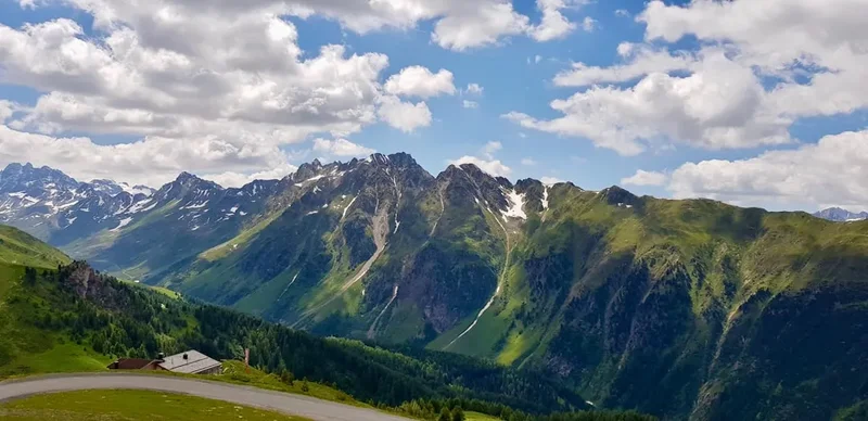
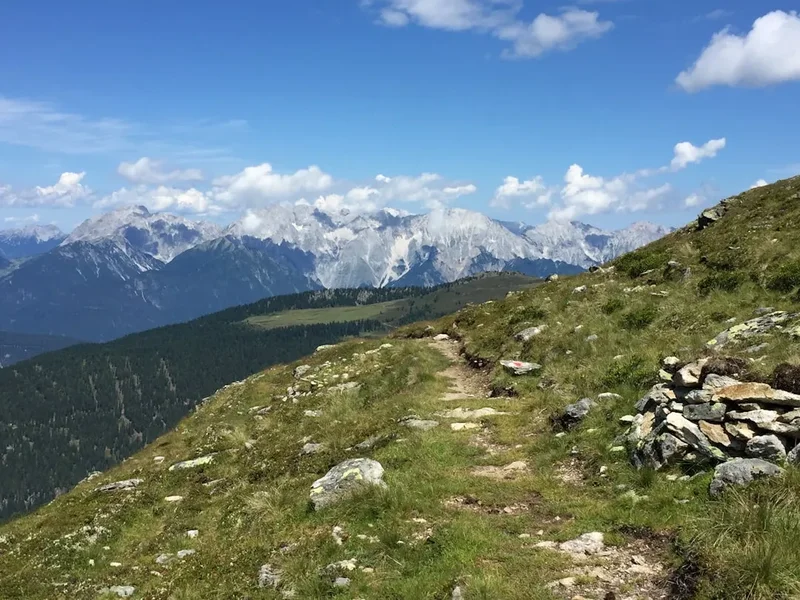
The Zillertal Alps High Route is a high-altitude odyssey that stays almost exclusively above the 2,000-metre mark, dipping into the valleys only at the very beginning and end of the circuit. It is a journey of contrasts: from the lush, green pastures of the lower Zillertal valley to the stark, granite-dominated world of the high ridges. The trail is characterised by its "blocky" terrain—vast fields of granite boulders that require constant concentration and balance. While the path is exceptionally well-marked with the iconic red-white-red Austrian trail blazes, the physical toll of the constant ascent and descent cannot be overstated. Each day involves crossing a high col or "Joch," followed by a descent into a new hanging valley, only to climb again the following morning.
The scenery is dominated by the "Zillertal Main Ridge," a massive wall of rock and ice that forms the border between Austria and Italy. Peaks like the Hochfeiler (3,510 m) and the Großer Möseler (3,480 m) provide a dramatic backdrop, their glaciers glistening in the summer sun. The route is also a journey through the history of alpinism. The huts along the way, such as the Berliner Hütte with its grand wood-panelled dining hall and five-metre-high ceilings, feel more like mountain palaces than simple shelters. They represent a time when the exploration of the Alps was a grand social and scientific endeavour.
For the modern trekker, the Berliner Höhenweg offers a rare opportunity to disconnect from the world below. There are no roads, no cars, and often no mobile signal in the deep recesses of the mountains. The rhythm of the day is dictated by the sun, the weather, and the distance to the next hut. It is a test of endurance that rewards the walker with some of the most spectacular alpine panoramas in the world, including the famous view from the Olpererhütte over the Schlegeis Reservoir, which has become an iconic symbol of the Austrian Alps.
History and Cultural Context
The history of the Zillertal Alps High Route is inextricably linked to the development of the German and Austrian Alpine Clubs (DAV and ÖAV) in the late 19th century. Before the 1870s, these high valleys were the exclusive domain of chamois hunters, crystal seekers, and hardy local shepherds. The "Golden Age of Alpinism" saw a surge in interest from urbanites in Vienna, Munich, and Berlin, who sought to conquer the peaks and document the geology of the region. The Berliner Hütte, the oldest and most famous hut on the route, was built in 1879 by the Berlin Section of the German Alpine Club. Its opulent architecture was intended to reflect the prestige of the German capital, and it remains a protected cultural monument today, complete with its original dark wood carvings and historic photographs.
The trail itself was constructed over decades, with sections being linked together to create a continuous high-level route. Many of the paths were originally built by hand, using local granite to create "staircases" through steep couloirs and stable platforms across boulder fields. During the World Wars, the region saw significant tension due to its proximity to the Italian border, and some of the huts were used for military purposes or fell into disrepair. However, the post-war era brought a renewed passion for mountain hiking, and the route was fully modernised and connected into the circuit we see today.
Culturally, the Zillertal is one of the most traditional regions in Tyrol. The "Almabtrieb" (the ceremonial driving of cattle down from the mountain pastures in autumn) remains a major local event. While the high route stays above the primary grazing lands, the influence of Tyrolean culture is felt in every hut, from the hearty "Knödel" (dumplings) served for dinner to the traditional "Hüttenschuhe" (slippers) that every guest must wear. The mountains are not just a playground here; they are a deeply respected part of the local identity, shaped by centuries of survival in a harsh but beautiful environment.
Want more background? Read extended notes on history and cultural context → Learn more
Seasonal Highlights and Weather Reality
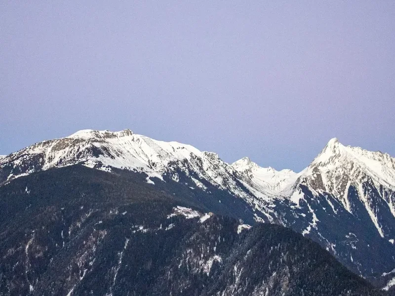
The window for completing the Zillertal Alps High Route is relatively narrow, typically spanning from early July to mid-September. Outside of this period, the high passes (many of which exceed 2,700 metres) are often choked with snow, making the route impassable for anyone without advanced mountaineering skills and equipment. Even in the height of summer, snow can fall at any time, and it is not uncommon for a summer storm to leave a dusting of white on the higher sections of the trail.
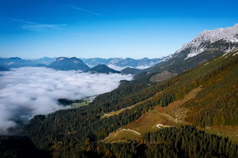
July is the month of alpine flowers. The meadows around the Gamshütte and the Friesenberghaus erupt in a riot of colour, with gentians, alpenrose, and edelweiss clinging to the rocky slopes. The days are long, but the risk of afternoon thunderstorms is at its highest. These storms can be violent and sudden, bringing lightning and hail to the exposed ridges. August offers the most stable weather and the warmest temperatures, though the huts are at their most crowded during this time. By September, the air becomes crisp and clear, providing the best visibility for photography, though the nights begin to freeze and the first permanent autumn snows may arrive toward the end of the month.
Weather in the Zillertal Alps is influenced by both Atlantic and Mediterranean systems. A "Föhn" wind from the south can bring unseasonably warm temperatures and exceptional clarity, but it is often followed by a "Kaltfront" (cold front) that can drop the temperature by 15 degrees Celsius in a matter of hours. Walkers must be prepared for all four seasons in a single day. If the clouds descend, navigation on the boulder fields becomes significantly more difficult, as the red-white-red markers can be obscured by mist.
Recommended Itinerary
9-Day Zillertal Alps High Route Itinerary
Day 1: Finkenberg to Gamshütte
- Distance: 12 km
- Elevation gain: 1,100 m
- Time: 4–5 hours
- Start in the village of Finkenberg (840 m)
- Steep ascent through dense larch and spruce forests
- Pass through the Hermann-Hecht-Weg, a well-maintained but relentless climb
- Arrive at Gamshütte (1,921 m), perched on a grassy shoulder with views back down to Mayrhofen
- A perfect "warm-up" day to test your legs and lungs for the altitude
Day 2: Gamshütte to Friesenberghaus
- Distance: 14 km
- Elevation gain: 1,100 m
- Time: 8–9 hours
- The "Long Day" – a demanding traverse across multiple steep gullies and ridges
- Cross the Graue Platte (Grey Slab), a section of smooth granite requiring care
- Pass through the Wesendlekar, a high alpine cirque often holding snow late into summer
- Arrive at Friesenberghaus (2,498 m), a hut with a moving history related to the exclusion of Jewish members from alpine clubs in the 1920s
- This is one of the most physically taxing days due to the constant "up and down" nature of the traverse
Day 3: Friesenberghaus to Olpererhütte
- Distance: 6 km
- Elevation gain: 500 m
- Time: 3–4 hours
- A shorter day allowing for recovery or side trips
- Ascent to the Friesenbergscharte (2,698 m) for views of the Olperer glacier
- Descend toward the Olpererhütte (2,388 m)
- Cross the famous "Instagram Bridge" just before the hut, with the Schlegeis Reservoir far below
- Afternoon can be spent climbing the nearby Riepenkopf (2,905 m)
Day 4: Olpererhütte to Furtschaglhaus
- Distance: 15 km
- Elevation gain: 800 m
- Time: 5–6 hours
- Long descent from the hut to the shores of the Schlegeis Reservoir (1,782 m)
- Flat walk along the turquoise waters of the dam
- Relentless zigzag ascent from the end of the lake up to the Furtschaglhaus (2,295 m)
- The hut sits directly opposite the Schlegeis glacier and the Hochfeiler, the highest peak in the Zillertal
Day 5: Furtschaglhaus to Berliner Hütte via Schönbichler Horn
- Distance: 12 km
- Elevation gain: 900 m gain, 1,100 m descent
- Time: 6–7 hours
- The "Queen Stage" of the route
- Steep climb to the Schönbichler Horn (3,134 m), the highest point on the trek
- The final 100 metres to the summit are cable-secured (A/B grade via ferrata)
- Spectacular 360-degree views of the main alpine ridge
- Long, technical descent over granite blocks to the historic Berliner Hütte (2,042 m)
Day 6: Berliner Hütte to Greizer Hütte
- Distance: 10 km
- Elevation gain: 1,200 m
- Time: 5–6 hours
- Descend into the Zemmgrund valley before climbing again
- Ascent to the Mörchenscharte (2,876 m), a narrow notch in the ridge
- The descent from the pass involves a steep ladder and cable-secured sections
- Cross the Floitengrund valley floor before a final short climb to Greizer Hütte (2,227 m)
Day 7: Greizer Hütte to Kasseler Hütte
- Distance: 15 km
- Elevation gain: 800 m
- Time: 8–9 hours
- Known as the "Seven Valleys" walk due to the numerous ridges crossed
- A very long traverse with significant exposure in places
- Cross the Lapenscharte (2,701 m)
- Arrive at Kasseler Hütte (2,178 m), located in the remote and wild Stillupgrund
Day 8: Kasseler Hütte to Karl-von-Edel-Hütte
- Distance: 14 km
- Elevation gain: 1,000 m
- Time: 9 hours
- The "Aschaffenburger Weg" – the most technical and exposed section of the entire route
- Requires absolute sure-footedness and a head for heights
- Multiple cable-secured sections and narrow ledges
- Arrive at Karl-von-Edel-Hütte (2,238 m), overlooking the Mayrhofen valley
Day 9: Karl-von-Edel-Hütte to Mayrhofen
- Distance: 12 km
- Elevation: 1,500 m descent
- Time: 4–5 hours
- Optional ascent of the Ahornspitze (2,973 m) before descending
- Long descent via the Ahorn cable car station or the steep hiking path
- Finish in the bustling town of Mayrhofen
- Celebratory meal in one of the many traditional Tyrolean restaurants
Important Notes:
- Hut reservations are mandatory and should be made months in advance
- The "Aschaffenburger Weg" (Day 8) can be bypassed via the valley if weather is poor
- Always check the "Hüttenbuch" (hut book) for the latest weather updates before leaving each morning
- Carry enough cash (Euros) as many huts do not accept credit cards
Planning and Bookings
Book Your Trip
Everything you need to plan your journey
Accommodation
Find places to stay near Innsbruck
Flights
Search flights to Innsbruck
Essential Preparation
The Zillertal Alps High Route is a serious undertaking that requires significant physical and logistical preparation. Walkers should be comfortable with "Black" rated trails (T4 on the SAC scale), which involve steep terrain, occasional use of hands for balance, and exposure. Training should focus on weighted pack carries and steep elevation gains. It is highly recommended to spend at least two days in Innsbruck or Mayrhofen (633 m) prior to starting to begin the acclimatisation process.
Logistically, the most important step is joining an Alpine Club (such as the ÖAV, DAV, or AAC). Membership provides significant discounts on hut stays (often 50% or more), priority for bookings, and comprehensive mountain rescue insurance, which is essential for this route. Mayrhofen is the primary hub for the trek, offering numerous gear shops, supermarkets, and a dedicated Alpine Club office for last-minute advice.
Trail Accommodation
Accommodation on the Berliner Höhenweg is provided by a network of mountain huts (Hütten). These are not hotels; they are functional mountain shelters designed to provide safety, food, and rest. Most huts offer two types of accommodation: "Zimmerlager" (small rooms with 2–4 beds) and "Matratzenlager" (large dormitory rooms with 10–20 mattresses side-by-side).
Hut Facilities:
- Dormitory mattresses with blankets and pillows (silk or cotton liner required)
- Common dining rooms serving breakfast and multi-course dinners
- Drying rooms for wet gear and boots
- Limited hot showers (usually €3–€5 for 3 minutes)
- Shared toilets and washrooms
- "Hüttenschuhe" (communal slippers) provided at the entrance
What Huts Don't Provide:
- Towels or toiletries
- Private bathrooms (in most cases)
- Reliable WiFi or mobile charging (some huts have limited solar charging)
- Free drinking water (tap water is usually potable, but bottled water is sold)
Booking Requirements:
- Bookings are made directly with each hut via the "Hütten-Holiday" online system or email
- High season (August) bookings should be made 4–6 months in advance
- Costs: Approximately €60–€80 per night for half-board (dinner, bed, breakfast) for Alpine Club members
Required Gear
- Alpine trekking boots - Category B/C, stiff sole for boulder hopping, waterproof
- Waterproof shell - High-quality jacket and trousers (Gore-Tex or similar)
- Insulating layers - Down or synthetic jacket, fleece, and merino base layers
- Backpack - 35–45 litres with a high-quality harness and rain cover
- Sleeping bag liner - Silk or cotton (mandatory for hygiene in huts)
- Trekking poles - Essential for saving knees on the 12,000 m of descent
- Navigation - Topographic maps (Alpenvereinskarte 35/1 and 35/2) and a compass
- First aid kit - Including blister plasters, emergency whistle, and a bivy bag
What to Bring
- Cash (Euros) - Essential for huts; many have no card terminals or unreliable satellite links
- Alpine Club Membership Card - For discounts and insurance
- Water treatment - While tap water is usually fine, a filter or tablets are useful for stream water
- Sun protection - SPF 50+ sunscreen, lip balm, and Category 3 or 4 sunglasses
- Personal hygiene - Biodegradable soap, travel towel, and earplugs (essential for dorms)
- High-energy snacks - Nuts, dried fruit, and chocolate (lunch is not usually included in half-board)
- Headlamp - For navigating dark dormitories or early starts
- Mobile power bank - To keep phones charged for navigation and emergencies
Permits
There is no formal "permit" required to walk the Zillertal Alps High Route. The mountains are open to the public, and there are no trail fees. However, the "permit" to successfully complete the route is your hut reservation. Wild camping is strictly prohibited throughout the High Alps Nature Park Zillertal Alps, and offenders face heavy fines. Therefore, your ability to walk the route is entirely dependent on securing a bed in the huts.
Booking Strategy:
- Plan your itinerary in reverse if the standard direction is full
- Use the official DAV/ÖAV booking portal (Hütten-Holiday)
- If a hut appears full online, call them directly; they often hold a few spots for last-minute arrivals or Alpine Club members
- Always cancel your booking if your plans change; "no-shows" are a major problem for hut wardens and can result in being blacklisted from the system
Costs and Fees:
- Alpine Club Membership: ~€60–€80 per year (highly recommended)
- Hut Stay (Member): ~€12–€15 for a dorm bed, ~€45 for half-board
- Hut Stay (Non-Member): ~€25–€35 for a dorm bed, ~€55 for half-board
- Emergency Insurance: Included in Alpine Club membership; otherwise, ensure your travel insurance covers "search and rescue" up to 3,500 m
Other Activities in the Area
The Zillertal valley is a world-class destination for outdoor enthusiasts. Consider these additions to your trip:
- Hintertux Glacier: One of the few places in the world where you can ski 365 days a year. Even in summer, the "Nature's Ice Palace" tour takes you deep inside the glacier.
- Via Ferrata (Klettersteig): Mayrhofen is home to several famous via ferrata routes, including the "Zimmereben" and the "Huterlaner," which offer thrilling vertical climbs with minimal equipment.
- Paragliding: The thermal conditions in the Zillertal are legendary. Tandem flights from the Penken or Ahorn mountains provide a bird's-eye view of the route you just walked.
- Schlegeis 131: For adrenaline seekers, this involves a "Giant Swing" and a via ferrata route built directly onto the face of the 131-metre-high Schlegeis Dam.
- Innsbruck Old Town: Spend a day exploring the Tyrolean capital, visiting the Golden Roof (Goldenes Dachl) and taking the Nordkette cable car for views over the city.
Safety and Conditions
Alpine Hazards: The Berliner Höhenweg is a high-alpine route where the environment is inherently dangerous. The primary risks include falls on steep terrain, rockfall in narrow gullies (especially on the Mörchenscharte), and lightning strikes on exposed ridges. Sure-footedness is non-negotiable; many sections of the trail consist of "floating" boulders that can shift underfoot. If you suffer from vertigo, sections like the Aschaffenburger Weg will be extremely challenging and potentially dangerous.
Weather Monitoring: Always consult the "ZAMG" (Central Institution for Meteorology and Geodynamics) mountain forecast. In the Alps, weather usually arrives from the west. If you see "cumulus congestus" clouds (towering cauliflower-like clouds) forming before noon, there is a high probability of afternoon thunderstorms. If caught in a storm on a ridge, descend immediately, move away from wire cables, and adopt a crouching position on your backpack to insulate yourself from the ground.
Snow and Ice: Even in August, north-facing slopes and high passes can have hard-packed snow. If the snow is frozen, a slip can be fatal. While crampons are not usually required for the standard route in mid-summer, a lightweight pair of "spikes" can provide peace of mind for early-season crossings. Always ask the hut warden about the current conditions of the next day's pass; they are the most reliable source of information.
Emergency Procedures: The European emergency number is 112. If you do not have a signal, the "Alpine Distress Signal" involves giving a visible or audible signal (whistle, light) six times a minute, then waiting a minute and repeating. Response is three times a minute.
Side Trips and Points of Interest
Schönbichler Horn (3,134 m): While this is part of the main route, it is also a peak in its own right. Many walkers leave their heavy packs at the junction and scramble the final few metres to the summit cross. It offers the best view of the Zillertal Main Ridge and the massive glaciers of the Waxeggkees and Furtschaglkees.
The Olperer Bridge: Located just a few minutes from the Olpererhütte, this simple suspension bridge has become a global sensation. When photographed from the right angle, it appears to hang directly over the turquoise Schlegeis Reservoir. It is best visited at sunrise to avoid the queues of day-hikers.
Berliner Hütte Architecture: Take the time to explore the interior of the Berliner Hütte. The "Damensalon" (Ladies' Lounge) and the grand dining hall are masterpieces of 19th-century craftsmanship. The hut even has its own historic post office and a small museum dedicated to the history of the Zillertal Alps.
Ahornspitze (2,973 m): On the final day, the ascent of the Ahornspitze from the Karl-von-Edel-Hütte is a classic. It is a steep scramble but provides a final, commanding view of the entire High Route stretching back toward the south. On a clear day, you can see as far as the Grossglockner, Austria's highest peak.
Leave No Trace
The High Alps Nature Park Zillertal Alps is a protected sanctuary for rare alpine flora and fauna. The ecosystem at 2,500 metres is extremely fragile; a single footprint on alpine moss can take decades to heal. As a visitor, you have a moral and legal obligation to minimise your impact.
Core Principles:
- Carry out all rubbish, including organic waste like banana skins and apple cores, which do not decompose at high altitudes and can be harmful to local wildlife
- Stay strictly on the marked trails to prevent erosion and protect the nesting sites of ground-dwelling birds like the Ptarmigan
- Never pick wildflowers; many species, such as the Edelweiss and the Turk's Cap Lily, are strictly protected by law
- Use the toilets provided in the huts; if you must go on the trail, ensure you are at least 50 metres from water sources and bury waste deeply
- Respect the silence of the mountains; loud music and drones are prohibited in the Nature Park
- Observe marmots and chamois from a distance; do not attempt to feed them, as this disrupts their natural foraging behaviour