
Zermatt to Saas-Fee: The High Alpine Trail
The traverse from Zermatt to Saas-Fee is widely considered one of the most spectacular high-altitude walking experiences in the Swiss Alps. This journey, often referred to as the "Europaweg" combined with the "Höhenweg Balfrin," connects two of Switzerland's most iconic car-free mountain villages. Spanning approximately 35 kilometres with a staggering 2,800 metres of elevation gain, this is not a route for the faint-hearted. It is a "balcony trail" in the truest sense, clinging to the steep western slopes of the Mischabel massif, offering uninterrupted views of the Matterhorn, the Weisshorn, and the Zinalrothorn. The trail takes walkers through ancient larch forests, across vast boulder fields, and over the world’s longest pedestrian suspension bridge, the Charles Kuonen Bridge. This is a journey through the heart of the Valais, where the air is thin, the peaks are jagged, and the sense of alpine scale is overwhelming. It demands physical stamina, a steady head for heights, and a deep respect for the volatile mountain environment.
- Distance: 35.0 km total
- Duration: 3–4 days
- Season: July to September (strictly snow-dependent)
- Accommodation: Mountain huts (Europahütte) and mountain village hotels (Grächen)
- Highest point: Approximately 2,700 m (near the Galenalp)
- Difficulty: Challenging (T3/T4 on the Swiss Alpine Scale)
- Direction: Usually walked from Zermatt to Saas-Fee, but reversible
Overview
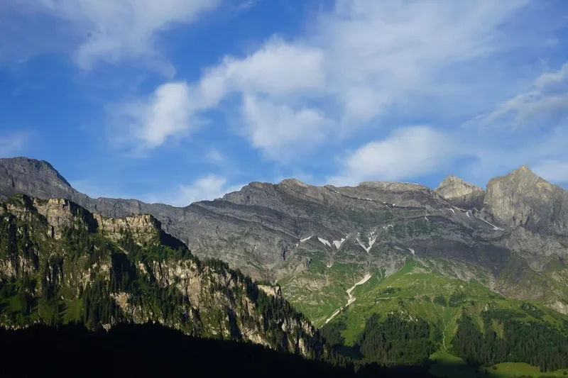
The Zermatt to Saas-Fee High Alpine Trail is a masterclass in Swiss engineering and natural grandeur. The route is divided into two distinct phases: the Europaweg, which runs from Zermatt to Grächen, and the Höhenweg Balfrin, which continues from Grächen to Saas-Fee. Together, they form a high-altitude horseshoe around the Mattertal and Saastal valleys. The terrain is characterised by its "balcony" nature—you are frequently walking on a narrow path cut directly into the mountainside, with hundreds of metres of vertical drop on one side and towering 4,000-metre peaks on the other. This provides a perspective on the Alps that valley-floor walkers never experience; you are eye-level with glaciers and the soaring granite spires of the Valais.
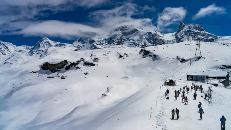
One of the defining features of this trail is its technical variety. Walkers will transition from the manicured, flower-laden streets of Zermatt into rugged, sun-bleached larch forests where the scent of pine is thick in the air. As the elevation increases, the forest gives way to "block fields"—vast expanses of granite boulders that require careful footwork. The path is frequently reinforced with steel cables and wooden steps, particularly on the steeper sections between the Europahütte and Grächen. The highlight for many is the Charles Kuonen Suspension Bridge, a 494-metre-long steel structure that hangs 85 metres above the Grabengufer ravine. Crossing it is a test of nerves, as the transparent mesh floor allows you to see the abyss beneath your boots.
The climate in this part of Switzerland is surprisingly dry, as the high peaks of the Valais create a rain shadow. However, the altitude means that weather can shift from blistering sunshine to a freezing alpine storm in less than thirty minutes. The trail requires a high level of fitness, as the daily elevation gains are significant, often exceeding 1,000 metres in a single day. For those who persevere, the reward is a constant, shifting panorama of the "Big Three": the Matterhorn (4,478 m), the Dom (4,545 m), and the Weisshorn (4,506 m). This is a trek that captures the raw, unyielding spirit of the Swiss Alps, providing a profound sense of isolation despite being only a few kilometres from world-class resorts.
History and Cultural Context
The history of the Zermatt to Saas-Fee route is inextricably linked to the birth of mountaineering in the 19th century. Zermatt rose to global fame following the first ascent of the Matterhorn by Edward Whymper in 1865, while Saas-Fee developed as a mountaineering hub under the influence of local priest Johann Josef Imseng, who is credited with being the first person in Switzerland to use skis. For decades, the only way to travel between these two valleys was via the high glacier passes or the long, arduous trek down to the valley floor at Stalden and back up again.
The Europaweg itself is a relatively modern creation, officially opened in 1997 to provide a high-level hiking connection that avoided the valley floor. It was designed to be part of the "Tour of Monte Rosa," a long-distance circuit around the second-highest mountain in the Alps. However, the trail has faced significant geological challenges. The steep slopes of the Mischabel massif are geologically active, prone to rockfalls and landslides. In 2010, the original bridge over the Grabengufer was destroyed by a rockfall just weeks after opening. It took seven years of planning and fundraising to construct the current Charles Kuonen Suspension Bridge, which was engineered to be more resilient and was opened in 2017.
Culturally, the region is the heartland of the Walser people—a Germanic group that migrated from the Bernese Oberland in the 12th and 13th centuries. Their influence is visible in the unique architecture of the villages you pass through. Look for the "Stadel"—traditional wooden granaries built on stone stilts with large circular flat stones (called "Mäuseplatten") designed to prevent mice and rats from climbing into the grain stores. The language spoken here is "Wallisertitsch," a distinct and archaic dialect of Swiss German that can be difficult even for other Swiss citizens to understand. Walking this trail is not just a physical challenge; it is a journey through a landscape that has been shaped by centuries of hardy mountain farming and the relentless pursuit of the "Golden Age" of alpinism.
Want more background? Read extended notes on history and cultural context → Learn more
Seasonal Highlights and Weather Reality
The window for completing the Zermatt to Saas-Fee High Alpine Trail is remarkably short. Due to its high elevation—much of the trail sits between 2,200 and 2,700 metres—snow can linger well into the summer. The official season typically runs from early July to late September. Attempting the trail outside of this window is dangerous and often impossible without full mountaineering equipment, as steep couloirs remain filled with hard-packed snow and ice, making the narrow paths impassable.
July and August: This is the peak season. The alpine wildflowers are in full bloom, including the iconic Edelweiss and Gentian. The weather is generally stable, with long daylight hours. However, afternoon thunderstorms are common in the Alps. These "heat storms" can develop rapidly, bringing heavy rain, lightning, and a sudden drop in temperature. It is essential to reach your destination or a safe shelter by mid-afternoon.
September: Many experienced hikers consider September the best month for this trail. The air is crisper and clearer, providing the best visibility for photography. The summer crowds have thinned, and the larch trees begin to turn a brilliant golden-yellow toward the end of the month. However, the days are shorter, and the first dusting of autumn snow can occur at any time, potentially closing the higher sections of the trail.
Weather Reality: Even in mid-summer, temperatures at 2,500 metres can hover near freezing in the early morning. The sun at this altitude is incredibly intense, and the risk of heat exhaustion is real on the long, exposed climbs. Conversely, if a weather front moves in from the north or west, the trail can be shrouded in "Nebal" (thick fog), making navigation through the boulder fields difficult. Always check the MeteoSwiss "Local Forecast" for Zermatt and Saas-Fee before setting out.
Recommended Itinerary
3-Day Zermatt to Saas-Fee Itinerary
Day 1: Zermatt to Europahütte
- Distance: 12 km
- Elevation gain: 1,050 m
- Elevation loss: 400 m
- Time: 5–6 hours
- Start at Zermatt railway station (1,608 m) and follow signs for "Europaweg" via Tufteren
- The trail climbs steeply through larch and stone pine forests
- Pass through the hamlet of Tufteren, offering one of the most famous "postcard" views of the Matterhorn
- Continue traversing the mountainside toward Sunnegga and Blauherd
- The path becomes more rugged as you approach the Europahütte (2,265 m)
- Arrive at the hut in time for a sunset view over the Weisshorn
- This day serves as a rigorous introduction to the elevation gains required for the trek
Day 2: Europahütte to Grächen
- Distance: 14 km
- Elevation gain: 850 m
- Elevation loss: 1,500 m
- Time: 6–7 hours
- This is the "Queen Stage" of the Europaweg, featuring the Charles Kuonen Suspension Bridge
- Cross the 494-metre bridge early in the morning to avoid the midday winds
- The trail involves significant "ups and downs" as it crosses several deep ravines
- Expect sections with fixed steel cables for security on narrow ledges
- Pass through the "Grat" section, the highest point of the day, with views down into the Mattertal
- A long, knee-jarring descent leads down into the village of Grächen (1,619 m)
- Grächen is a beautiful, sun-drenched terrace village with plenty of hotel options
Day 3: Grächen to Saas-Fee (The Höhenweg Balfrin)
- Distance: 16 km
- Elevation gain: 900 m
- Elevation loss: 700 m
- Time: 7 hours
- From Grächen, follow signs for the "Höhenweg Saas-Fee"
- The trail rounds the "nose" of the mountain, transitioning from the Mattertal to the Saastal
- This section is arguably more technical than the Europaweg, with several exposed sections requiring a steady head
- Pass through the spectacular rock amphitheatres beneath the Balfrin glacier
- The trail stays high, offering views of the Fletschhorn and the Weissmies across the valley
- Final descent into the glacier village of Saas-Fee (1,800 m)
- Celebrate the completion of the traverse in the "Pearl of the Alps"
Important Notes:
- The Europahütte is the only mountain hut directly on the first half of the route; it must be booked months in advance
- If the Europaweg is closed due to rockfall (check local alerts), a lower alternative route via Herbriggen is usually available
- The trail is physically demanding; ensure you have completed several 1,000 m+ training hikes before attempting
- Water sources are limited between huts; carry at least 2.5 litres per person
- The direction from Zermatt to Saas-Fee is preferred as it keeps the Matterhorn at your back, allowing you to focus on the technical path ahead, though many prefer the reverse to keep the Matterhorn in sight
Planning and Bookings
Book Your Trip
Everything you need to plan your journey
Accommodation
Find places to stay near Visp
Flights
Search flights to Visp
Essential Preparation
Preparation for the Zermatt to Saas-Fee traverse begins with physical conditioning. The trail involves sustained climbs and descents on uneven, rocky terrain. You should be comfortable walking 7–8 hours a day for multiple consecutive days. Acclimatisation is also a factor; if you are arriving from sea level, spend at least two days in Zermatt (1,608 m) or taking cable cars to higher elevations like Gornergrat to help your body adjust to the thinner air.
Logistically, you must coordinate your arrival in Zermatt. Zermatt is a car-free village. If you are driving, you must park your vehicle in the large multi-storey car park in Täsch and take the shuttle train (running every 20 minutes) into Zermatt. If arriving by air, the Swiss Rail (SBB) system is incredibly efficient; trains from Zurich or Geneva airports connect via Visp directly to Zermatt. Ensure you have downloaded the SBB Mobile app and the MeteoSwiss app for real-time transport and weather updates.
Trail Accommodation
Accommodation on this route is a mix of traditional mountain huts and village hotels. Because the trail is popular and the options are limited, booking in advance is non-negotiable during the July–August peak.
Europahütte (2,265 m): This is the primary hut on the Europaweg. It is a modern, wooden structure perched on a steep slope.
- Facilities: Dormitory-style sleeping (Matratzenlager) with blankets provided. Small private rooms are sometimes available.
- Dining: Half-pension (dinner and breakfast) is the standard booking. The food is hearty—expect Rösti, pasta, or stew.
- What's NOT provided: Towels, toiletries, or silk sleeping bag liners (which are mandatory for hygiene).
- Cost: Approximately 85–100 CHF per night for half-pension.
- Booking: Via the hut's official website or the Swiss Alpine Club (SAC) portal.
Grächen: This village serves as the midpoint. It offers a wide range of accommodation from budget hostels to 4-star wellness hotels. Staying here allows for a "soft" night with a hot shower and a proper bed before the final push to Saas-Fee.
- Facilities: Full hotel services, supermarkets for restocking, and pharmacies.
- Cost: Varies widely (80 CHF to 250 CHF per night).
Saas-Fee: The finish line. Like Zermatt, it is car-free and offers extensive accommodation. It is recommended to book a night here to enjoy the village after your trek.
Required Gear
- Hiking Boots: Category B/C boots with stiff soles and excellent ankle support. The boulder fields will punish soft-soled trainers.
- Backpack: A 30–40 litre pack is sufficient if staying in huts. Ensure it has a high-quality rain cover.
- Clothing: The layering system is vital. Include a moisture-wicking base layer, a fleece or down mid-layer, and a high-quality Gore-Tex shell jacket.
- Navigation: While the trail is well-marked with yellow signs and red-white-red paint blazes, carry a physical map (Swisstopo 1:25,000 sheet 1328 Randa) and an offline GPS app like Outdooractive or SwissMobile.
- Safety Gear: An emergency whistle, a basic survival bag (bivvy bag), and a fully charged mobile phone with the "Echo112" emergency app installed.
- Trekking Poles: Highly recommended to save your knees on the 1,500 m descent into Grächen.
What to Bring
- Silk Liner: Mandatory for sleeping in the Europahütte.
- Water Treatment: While hut water is generally safe, a lightweight filter (like a Sawyer Squeeze) is useful for collecting water from alpine streams.
- Sun Protection: High-factor sunscreen (SPF 50), polarised sunglasses, and a wide-brimmed hat. The alpine UV is fierce.
- Personal First Aid: Focus on blister prevention (Compeed), ibuprofen, and any personal medications.
- Snacks: High-energy foods like nuts, dried fruit, and Swiss chocolate. You can buy lunch packs at the huts, but they are expensive.
- Cash: While many Swiss huts now take cards, some still prefer Swiss Francs (CHF) for small purchases or if the satellite connection is down.
- Earplugs: Essential for a good night's sleep in a crowded dormitory.
Permits
One of the great joys of hiking in Switzerland is the lack of a formal permit system for the trails themselves. You do not need to pay an entry fee to walk the Europaweg or the Höhenweg Balfrin, nor do you need to register at the trailhead. The mountains are free and open to all who respect them.
However, "permit-free" does not mean "planning-free." Your "permit" is effectively your hut reservation. During the high season, the Europahütte is frequently fully booked. If you arrive without a reservation, the hut warden is legally allowed to turn you away if they are at capacity, which could leave you in a dangerous situation as there is no legal camping allowed on the mountainside.
Wild Camping Regulations: It is important to note that wild camping is strictly regulated in the Valais. In the forest zones and near the villages, it is generally prohibited. Above the treeline (the "Alpine Zone"), it is technically permitted for a single night for small groups, provided you are not in a protected nature reserve or a "Jagdbanngebiet" (wildlife protection area). However, the terrain on this specific trail is so steep and rocky that finding a flat, safe spot for a tent is nearly impossible. It is strongly advised to use the established huts and hotels.
Cost Considerations: While the trail is free, the associated costs are high. Switzerland is expensive. Budget for:
- Train from Visp to Zermatt: ~37 CHF (one way, without Half-Fare card)
- Europahütte Half-Pension: ~90 CHF
- Hotel in Grächen: ~120 CHF
- PostBus from Saas-Fee back to Visp: ~20 CHF
Other Activities in the Area
The Valais region is a playground for outdoor enthusiasts. If you have extra days, consider these world-class experiences:
- Gornergrat Railway (Zermatt): Take the highest open-air rack railway in Europe to the summit of Gornergrat (3,089 m) for a panoramic view of 29 peaks over 4,000 metres, including the Monte Rosa massif.
- Matterhorn Glacier Paradise: Ride the world's highest 3S cableway to the Klein Matterhorn (3,883 m). You can visit an ice palace carved inside the glacier and see as far as the Mediterranean on a clear day.
- Saas-Fee Glacier Tour: Hire a guide in Saas-Fee for a "Feegletscher" trek. You’ll wear a harness and crampons to walk across the crevassed glacier safely.
- The Hannigalp (Grächen): If you have a spare afternoon in Grächen, take the gondola to Hannigalp for a more relaxed walk with views of the Bietschhorn.
- Thermal Baths in Brigerbad: After finishing your trek, head to the thermal baths near Visp to soak your tired muscles in the largest open-air thermal centre in the Alps.
- Via Ferrata: Both Zermatt and Saas-Fee offer spectacular Via Ferrata routes (like the Schweifinen in Zermatt) for those who want to add some vertical rock climbing to their trip.
Safety and Conditions
Rockfall Risk: This is the most significant objective hazard on the Zermatt to Saas-Fee trail. The Mischabel massif is composed of metamorphic rock that is prone to crumbling, especially after heavy rain or during periods of rapid snowmelt. Several sections of the Europaweg are fitted with protective tunnels or galleries. Never linger in areas marked with "Steinschlag" (rockfall) signs. If you hear a sound like a gunshot or a distant rumble, look up immediately.
Vertigo and Exposure: This trail is not suitable for those who suffer from severe acrophobia. There are numerous sections where the path is less than a metre wide with a sheer drop of several hundred metres. While cables are often provided, they are for balance, not for clipping in like a Via Ferrata. The Charles Kuonen Bridge, while perfectly safe, moves slightly in the wind and can be distressing for some walkers.
Alpine Weather: Hypothermia is a risk even in August. If the clouds descend and the temperature drops, you can lose body heat rapidly, especially if you are wet. Always carry a waterproof layer and a warm hat. If a thunderstorm is imminent, get off the high ridges and away from the steel cables of the suspension bridge immediately.
Emergency Contacts:
- REGA (Swiss Air Rescue): 1414
- General Emergency: 112
- The REGA app is highly recommended; it sends your exact GPS coordinates to the rescue centre with a single tap.
Trail Markings: Follow the red-white-red blazes. If you find yourself on a path with blue-white-blue markings, you have accidentally joined an "Alpine Route" (T4-T6), which may involve glacier crossing or technical climbing. Turn back immediately unless you are equipped for such terrain.
Side Trips and Points of Interest
The Charles Kuonen Suspension Bridge: Named after its primary sponsor, a psychologist and winery owner, this bridge is a marvel of modern engineering. It was built in just ten weeks. Walking across it takes about 10 minutes. The bridge uses a patented damping system to prevent excessive swinging, but you will still feel the vibration of other hikers. It is the definitive highlight of the Europaweg.
The Matterhorn Reflection at Stellisee: On Day 1, a short detour from the main trail near Blauherd leads to Stellisee. On a calm morning, the Matterhorn is perfectly reflected in the still waters of this alpine lake. It is one of the most photographed spots in the world, and for good reason.
The "Ghost" Village of Ritzengrat: Along the trail, you will see abandoned stone foundations and old shepherd huts. These are remnants of a time when the high pastures were more heavily used for summer grazing. They offer a haunting glimpse into the difficult life of Valaisan farmers in centuries past.
The Balfrin Amphitheatre: On the final day between Grächen and Saas-Fee, the trail enters a massive natural cirque beneath the Balfrin peak. The scale of the rock walls here is intimidating, and you can often see chamois (mountain goats) or ibex perched on the seemingly vertical cliffs above you.
Leave No Trace
The Swiss Alps are a highly managed but fragile ecosystem. With thousands of hikers visiting each year, the "Leave No Trace" principles are essential to maintaining the beauty of the Valais.
Specific Guidelines for the Valais:
- Waste: There are no bins on the trail or at the huts for your personal rubbish. You must pack out everything, including organic waste like banana peels or apple cores, which decompose very slowly at high altitudes and can be harmful to local wildlife.
- Human Waste: Use the toilets at the huts or in the villages. If you are caught short on the trail, ensure you are at least 50 metres from any water source and bury your waste in a "cathole." Pack out your toilet paper in a sealed plastic bag.
- Flora and Fauna: Many alpine plants, such as the Edelweiss, are protected by law. Picking them can result in heavy fines. Similarly, do not approach or feed the marmots or ibex.
- Water: Do not use soap (even biodegradable soap) directly in alpine lakes or streams. The chemicals can disrupt the delicate balance of these nutrient-poor waters.
- Noise: Respect the silence of the mountains. Avoid using speakers or shouting, which can disturb both wildlife and other hikers seeking solitude.