Zanskar Valley Trek - Journey Through the Hidden Kingdom
The Zanskar Valley Trek is one of the most formidable and culturally immersive high-altitude journeys in the Indian Himalayas. Spanning approximately 150 kilometres through the remote Ladakh region, this trek traverses a landscape of stark, high-altitude desert, punctuated by emerald-green riverside oases and ancient Tibetan Buddhist monasteries that seem to cling precariously to sheer canyon walls. Often referred to as the "Grand Canyon of the Himalayas," the Zanskar region remained largely isolated from the modern world for centuries, protected by the formidable Zanskar Range to the north and the Great Himalayan Range to the south. This trek is not merely a physical challenge; it is a pilgrimage into a living museum of Indo-Tibetan culture, where the rhythm of life is still dictated by the seasons and the spiritual traditions of the Gompas (monasteries).
- Distance: 150.0 km (approximate, depending on side trips)
- Duration: 10–14 days
- Season: Mid-June to Mid-October (avoiding the winter freeze and peak monsoon in the lower foothills)
- Accommodation: Camping and traditional village homestays
- Highest point: Shingo La (5,091 m)
- Difficulty: Challenging (requires high-altitude experience and excellent physical fitness)
- Direction: Typically trekked from Remala (near Padum) to Darcha, or vice versa
Overview
The Zanskar Valley Trek offers a profound encounter with the raw power of geological forces and the resilience of human spirit. The route follows the course of the Zanskar River and its tributaries, carving through deep gorges where the rock strata are twisted into surreal patterns of ochre, purple, and grey. Unlike the lush, forested valleys of the southern Himalayas, Zanskar is a high-altitude cold desert. The air is thin and exceptionally dry, and the sun radiates with an intensity that requires constant protection. However, this aridity creates a landscape of unparalleled clarity, where snow-capped peaks over 6,000 metres stand in sharp relief against a deep indigo sky.
The trek is characterised by its dramatic transitions. One day you may be walking across wide, sun-baked river flats where the only sound is the crunch of glacial silt beneath your boots; the next, you are navigating narrow, precipitous trails etched into the side of a vertical cliff. The physical demands are significant, with multiple passes exceeding 4,000 metres and the final ascent over the Shingo La at 5,091 metres. Acclimatisation is the single most important factor for success, as the entire trek takes place at altitudes where oxygen levels are significantly lower than at sea level.
Culturally, the trek is a revelation. The Zanskaris have maintained a way of life that has changed little over the centuries. You will pass through small, whitewashed villages surrounded by fields of barley and peas, irrigated by ingenious systems of stone-lined channels. The hospitality of the local people is legendary; it is common to be invited into a traditional kitchen for a cup of butter tea (gur-gur cha). The spiritual heart of the trek lies in its monasteries, such as Karsha, Phugtal, and Bardan. These ancient institutions are not just religious centres but the social and educational hubs of the valley, housing priceless thangkas (religious paintings), ancient manuscripts, and vibrant monastic communities.
As road construction continues to penetrate deeper into the Zanskar Valley, the window to experience this trek in its traditional, isolated form is narrowing. While the new roads provide essential services to local communities, they are changing the character of the trail. For the modern adventurer, the Zanskar Valley Trek remains a bucket-list experience—a chance to walk through a landscape that feels truly primordial and to witness a culture that defines the word "endurance."
History and Cultural Context
The history of Zanskar is inextricably linked to the spread of Buddhism from India to Tibet and the subsequent rise of the Tibetan Empire. Historically, Zanskar was an independent kingdom, though it often fell under the suzerainty of the Ladakhi kings or the rulers of nearby Guge in Western Tibet. Its isolation was its greatest defence, allowing a unique form of Vajrayana Buddhism to flourish undisturbed. The valley is dotted with "Gompas" (monasteries) belonging to the Gelugpa (Yellow Hat) and Drukpa Kagyu schools, some of which date back to the 10th and 11th centuries, founded by the legendary translator Rinchen Zangpo.
The cultural landscape is dominated by the "Lhapa" (shamanic) traditions that predated Buddhism, which were eventually integrated into the Buddhist framework. This is evident in the local festivals, where masked "Cham" dances depict the victory of dharma over demonic forces. The social structure is traditionally communal, with the "Phaspun" system—a group of families who share a common deity and assist each other during births, marriages, and deaths—forming the backbone of village life.
In the 19th century, Zanskar was drawn into the "Great Game" between the British and Russian Empires. Explorers and surveyors, such as Alexander Cunningham and William Moorcroft, were among the first Europeans to document the region. However, it was the Hungarian scholar Alexander Csoma de Kőrös who perhaps left the most significant mark; he spent years in Zanskar (specifically at Zangla and Phugtal) in the 1820s, compiling the first Tibetan-English dictionary and opening the door for Western understanding of Tibetan language and culture.
Want more background? Read extended notes on history and cultural context → Learn more
Seasonal Highlights and Weather Reality
The trekking window for Zanskar is narrow, dictated by the opening and closing of high mountain passes. Unlike the rest of India, which experiences heavy monsoon rains from July to September, Zanskar lies in the rain shadow of the Himalayas. This makes it one of the few regions in the country suitable for trekking during the northern hemisphere's summer.
Mid-June to July: This is the early season. The passes, particularly Shingo La, may still have significant snow cover, requiring careful navigation and potentially the use of gaiters. The weather is generally clear, but river levels can be high due to snowmelt, making river crossings more challenging. The valleys are at their greenest as the barley crops begin to sprout.
August to September: This is the peak trekking season. The weather is most stable, with warm days (20°C to 25°C in the valleys) and cool to cold nights (dropping to 0°C or below at higher camps). The passes are usually clear of snow, and the river levels begin to drop. This is also the time for many monastic festivals, which are a highlight for any visitor.
October: The shoulder season brings crisp, clear air and stunning autumn colours as the willow and poplar trees turn gold. However, the risk of early winter storms increases significantly. Temperatures at night can plummet well below freezing, and the high passes may close unexpectedly due to snowfall. Only experienced trekkers with high-quality cold-weather gear should attempt the route in late October.
Winter (November to May): The Zanskar Valley Trek is impassable during winter. The passes are buried under metres of snow, and the villages are cut off from the outside world. The only way in or out during this time is the "Chadar Trek"—a perilous journey over the frozen surface of the Zanskar River, which is a completely different undertaking requiring specialised skills and equipment.
Recommended Itinerary
10-Day Zanskar Valley Trek Itinerary (Remala to Darcha)
Day 1: Remala to Karsha
- Distance: 12 km
- Elevation gain: 150 m
- Time: 4–5 hours
- Begin the trek from Remala, following the Doda River towards the heart of Zanskar.
- The trail is relatively flat, allowing for final acclimatisation.
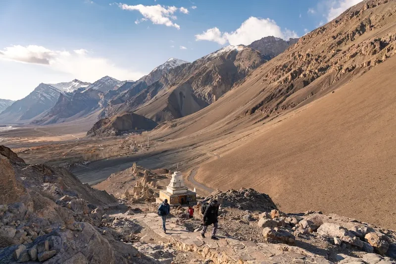
- Pass through the village of Pipiting with its prominent stupa.
- Arrive at Karsha, home to the largest and most important monastery in Zanskar.
- Explore Karsha Gompa, perched on a hillside with commanding views of the valley.
Day 2: Karsha to Padum and Bardan
- Distance: 16 km
- Elevation gain: 200 m
- Time: 5–6 hours
- Walk through Padum, the administrative capital of Zanskar, to restock supplies if necessary.
- Continue along the Lungnak River (a tributary of the Zanskar).
- The trail follows a newly constructed road section but remains scenic.
- Reach Bardan Gompa, famous for its massive prayer wheel and ancient rock carvings.
- Camp near the river below the monastery.
Day 3: Bardan to Purne
- Distance: 18 km
- Elevation gain: 350 m
- Time: 6–7 hours
- A longer day following the narrow gorge of the Lungnak River.
- The trail involves several "ups and downs" as it navigates the cliffside.
- Pass through the small settlements of Mune and Ichar.
- Cross a dramatic suspension bridge to reach Purne, a small village located at the confluence of the Tsarap and Kargyak rivers.
- Purne is the base for the excursion to Phugtal.
Day 4: Purne to Phugtal Monastery (Return Trip)
- Distance: 10 km (return)
- Elevation gain: 300 m
- Time: 4–5 hours
- A spectacular side trip to one of the most isolated monasteries in the world.
- The trail clings to the side of the Tsarap River gorge.
- Phugtal is built into a massive cave opening; the white buildings look like a honeycomb against the cliff.
- Visit the main prayer hall and the sacred spring inside the cave.
- Return to Purne for the night.
Day 5: Purne to Sking
- Distance: 14 km
- Elevation gain: 400 m
- Time: 5–6 hours
- Follow the Kargyak River upstream.
- The valley opens up, revealing wide pastures and towering peaks.
- Pass through the village of Yal, where you might see locals harvesting barley.
- Arrive at Sking (also spelled Shing), a picturesque village with traditional stone houses.
- Camp in the lush meadows surrounding the village.
Day 6: Sking to Kargyak
- Distance: 12 km
- Elevation gain: 250 m
- Time: 4 hours
- A shorter day to allow for rest before the high pass.
- Kargyak is the highest permanent settlement in the Zanskar Valley (approx. 4,050 m).
- The village is dominated by a large "mani" wall (stones carved with Buddhist mantras).
- Views of the monolithic Gonbo Rangjon peak begin to dominate the horizon.
- Spend the afternoon resting and hydrating.
Day 7: Kargyak to Shingo La Base (Lakong)
- Distance: 14 km
- Elevation gain: 450 m
- Time: 5–6 hours
- Walk towards the base of the Shingo La pass.
- Pass the base of Gonbo Rangjon, a sacred mountain that stands isolated like a giant tooth.
- The terrain becomes more rugged and alpine, with glacial moraine and small streams.
- Camp at Lakong (approx. 4,500 m), a high-altitude pasture used by nomadic shepherds.
- Prepare for a cold night and an early start.
Day 8: Lakong to Ramjak via Shingo La
- Distance: 16 km
- Elevation: 591 m gain to pass, 700 m descent
- Time: 7–9 hours
- The most challenging day of the trek.
- A steady climb over snow patches and scree to the summit of Shingo La (5,091 m).
- The pass is marked by thousands of colourful prayer flags fluttering in the wind.
- Enjoy panoramic views of the Lahaul and Zanskar ranges.
- A long, steep descent on the southern side into the Lahaul Valley.
- Camp at Ramjak, a rocky site below the glacier.
Day 9: Ramjak to Palamo
- Distance: 15 km
- Elevation loss: 600 m
- Time: 5–6 hours
- The trail follows the Jankar Nala river downstream.
- The landscape begins to change as you descend, with more vegetation appearing.
- Cross several streams (may require wading depending on the time of day).
- Reach Palamo, where the road head from Darcha is currently being extended.
- Final night of camping under the Himalayan stars.
Day 10: Palamo to Darcha and Onward
- Distance: 10 km
- Elevation loss: 300 m
- Time: 3–4 hours
- An easy walk along the river to the village of Darcha on the Manali-Leh Highway.
- Celebrate the completion of the trek with a hot meal at a local dhaba.
- Board a pre-arranged vehicle for the drive to Manali (approx. 4–5 hours via the Atal Tunnel) or back towards Leh.
Important Notes:
- This itinerary is a guide; actual walking times depend on fitness and acclimatisation.
- River crossings can be dangerous; always cross in the morning when water levels are lowest.
- Mules or horses are typically used to carry heavy gear; ensure your trekking agency treats animals ethically.
- The road is expanding; some sections of the "trail" may now follow dirt roads.
Planning and Bookings
Book Your Trip
Everything you need to plan your journey
Accommodation
Find places to stay near Leh
Flights
Search flights to Leh
Essential Preparation
The Zanskar Valley Trek requires meticulous planning due to its remoteness and extreme altitude. The most critical preparation is acclimatisation. It is mandatory to spend at least three nights in Leh (3,500 m) before starting the trek. During this time, engage in light activity, drink plenty of water, and avoid alcohol. Physical fitness should focus on cardiovascular endurance and leg strength; training with a weighted pack on hilly terrain for 3–4 months prior is highly recommended.
Logistically, you must decide between an organised trek (through an agency) or an independent trek. Most trekkers choose an agency, which provides a guide, cook, horseman, and all camping equipment. If trekking independently, you must be an expert navigator and carry all your own supplies, as village shops are extremely basic. Leh is the primary hub for all arrangements, including hiring guides and purchasing last-minute supplies.
Trail Accommodation
Accommodation on the Zanskar Valley Trek is a mix of camping and village homestays. There are no commercial hotels or developed mountain huts along the route.
Camping:
- Most organised treks use high-quality mountain tents.
- Campsites are usually located near water sources and villages.
- Toilet facilities in camps are typically "dry pit" tents.
- You must bring a high-quality sleeping bag rated to at least -10°C.
Homestays:
- Increasingly popular, homestays allow you to sleep in a traditional Zanskari house.
- Facilities are basic: a rug on a wooden floor in a communal room.
- Bedding (quilts) is usually provided, but using your own sleeping bag liner is recommended for hygiene.
- Toilets are traditional Ladakhi "dry" toilets (a hole in the floor over a composting pit).
- Costs: Approximately 1,000–1,500 Indian Rupees per night, including dinner and breakfast.
What is NOT provided:
- Electricity for charging devices (some homestays have limited solar power).
- Hot showers (bucket washes with heated water may be available for a small fee).
- Western-style toilets.
- WiFi or mobile signal.
Required Gear
- Trekking boots - Sturdy, waterproof, and well-broken-in. Ankle support is essential for rocky terrain.
- Down jacket - A high-quality, 700+ fill power jacket for cold evenings and the high pass.
- Hard-shell jacket - Waterproof and windproof (Gore-Tex or similar) for protection against sudden storms.
- Trekking trousers - Lightweight, quick-drying, and ideally wind-resistant.
- Base layers - Merino wool or synthetic wicking layers (top and bottom).
- Backpack - 50–65L if carrying your own gear; 20–30L daypack if using horses.
- Sleeping bag - 4-season rated (comfort rating -10°C or lower).
- Trekking poles - Highly recommended for steep descents and river crossings.
- Head torch - With extra batteries (essential for early starts and camp life).
- Sunglasses - Category 4 (glacier glasses) to protect against intense UV and snow blindness.
What to Bring
- Water purification - UV filter (SteriPen) or purification tablets. Do not drink untreated stream water.
- Sun protection - SPF 50+ sunscreen, lip balm with SPF, and a wide-brimmed hat.
- First aid kit - Including Diamox (for altitude), rehydration salts, blister kits, and broad-spectrum antibiotics.
- Personal toiletries - Biodegradable soap, wet wipes (for "dry" baths), and hand sanitiser.
- High-energy snacks - Trail mix, energy bars, chocolate, and electrolyte powder.
- Power bank - Solar chargers are effective in the high-altitude sun.
- Cash - Sufficient Indian Rupees for homestays, tips, and emergency transport. There are no ATMs on the trail.
- Micro-spikes - Useful if Shingo La has significant ice or hard-packed snow.
- Personal Locator Beacon (PLB) - Recommended for remote emergency communication.
Permits
Trekking in the Zanskar region requires specific permits issued by the Indian authorities. Regulations can change frequently, so it is essential to check the latest requirements in Leh before departure.
Inner Line Permit (ILP): While the main Zanskar Valley itself often falls under general travel areas, many routes approaching it (especially those near the border regions or coming from Leh) require an Inner Line Permit. This is mandatory for all foreign nationals and can be obtained online or through a registered travel agent in Leh. You will need to provide copies of your passport and visa.
Wildlife/Environmental Fees: Most trekking routes in Ladakh and Zanskar require the payment of a "Wildlife Fee" or "Green Tax." This is usually a nominal daily fee (approx. 20–50 Rupees per day) collected to support conservation efforts in the Hemis National Park and surrounding areas. If you are on an organised trek, your agency will typically handle this.
Lahaul Entry: If your trek ends in Darcha (Himachal Pradesh), you may need to register at the police check post in Darcha. Ensure you have multiple photocopies of your passport, visa, and permits, as check posts will often keep a copy.
Important Strategy: Do not leave permit acquisition to the last minute. While the process in Leh is generally efficient, government offices are closed on Sundays and public holidays. Allow at least one full working day in Leh to secure all necessary paperwork.
Other Activities in the Area
The regions surrounding the Zanskar Valley Trek offer a wealth of cultural and adventure opportunities:
- Leh Sightseeing: Explore the Leh Palace, Shanti Stupa, and the vibrant local markets. Leh is a fascinating blend of traditional Tibetan culture and modern Indian influence.
- Monastery Tours: Visit the great monasteries of the Indus Valley, including Hemis, Thiksey, and Alchi. Alchi is particularly famous for its 11th-century Kashmiri-style frescoes.
- White Water Rafting: The Zanskar River offers world-class rafting (Grade IV and V) through the spectacular Zanskar Gorge. This is usually done as a multi-day expedition from Padum to Nimmu.
- Pangong Tso and Nubra Valley: Take a multi-day jeep excursion to the high-altitude brackish lake of Pangong Tso or the sand dunes of the Nubra Valley, where you can ride Bactrian (two-humped) camels.
- Mountain Biking: The road from Leh to Khardung La (one of the highest motorable passes in the world) is a popular challenge for cyclists.
- Yoga and Meditation: Many centres in Leh and the surrounding villages offer retreats focusing on Tibetan Buddhist meditation and Himalayan yoga practices.
Safety and Conditions
Acute Mountain Sickness (AMS): This is the primary safety concern. The trek stays consistently above 3,500 metres and crosses a 5,000-metre pass. Symptoms include headache, nausea, dizziness, and fatigue. The only cure for serious AMS (HAPE or HACE) is immediate descent. Follow the "climb high, sleep low" rule and consider taking Acetazolamide (Diamox) after consulting a doctor.
River Crossings: Glacial streams can become raging torrents by mid-afternoon as the sun melts the ice upstream. Always plan to cross major streams early in the morning. Use trekking poles for stability and unbuckle your backpack's waist belt so you can jettison it if you fall.
Weather Extremes: The Himalayan weather is notoriously unpredictable. A clear morning can turn into a blizzard within an hour. Always carry your hard-shell jacket and warm layers in your daypack, regardless of how the sky looks when you leave camp.
Dehydration and Sunburn: The dry air and high UV levels lead to rapid dehydration and severe sunburn. Drink at least 4–5 litres of water daily and apply high-factor sunscreen every few hours. Cover your neck and ears, which are often overlooked.
Remote Location: There is no mobile signal or medical facility for most of the trek. A satellite phone (though restricted in India) or a satellite messaging device (like Garmin inReach, if permitted) is the only way to call for help. Ensure your trekking agency has a clear evacuation plan and that your travel insurance specifically covers "high-altitude trekking up to 6,000 metres" and "helicopter evacuation."
Side Trips and Points of Interest
Phugtal Monastery: As mentioned in the itinerary, this is the most significant side trip. Founded in the early 12th century, it remains one of the few monasteries in Ladakh that can only be reached on foot. The monastery is built around a natural cave, which is said to have been used by the Buddha's disciples and various sages for meditation. The library and the ancient frescoes are of immense historical value.
Gonbo Rangjon: This massive, isolated rock monolith stands at the head of the Kargyak Valley. It is considered a sacred mountain by the local Buddhists, who believe it to be the abode of protective deities. The sight of the peak at sunrise or under a full moon is one of the most iconic images of the Zanskar trek.
Zangla Palace: If you have extra days, a trip to Zangla (north of Padum) is worthwhile. The ruins of the old palace offer a glimpse into the lives of the Zanskari kings. It was here that Alexander Csoma de Kőrös spent the winter of 1823, working on his dictionary in a tiny, unheated room.
Stongdey Monastery: Located about 18 km from Padum, this is the second-largest monastery in Zanskar. It is perched on a rocky outcrop and is famous for its annual Gustor festival, featuring sacred masked dances. The climb to the monastery provides an excellent acclimatisation hike with views over the central Zanskar plain.
Leave No Trace
The high-altitude desert of Zanskar is an extremely fragile ecosystem. Decomposition rates are incredibly slow due to the cold and lack of moisture, meaning waste left behind can remain for decades. As tourism increases, the pressure on this environment is reaching a critical point.
Your responsibility as a walker:
- Carry Out All Trash: This includes "organic" waste like orange peels and nut shells, which do not decompose in the desert. Pack out all plastic, foil, and cigarette butts.
- Manage Human Waste: Use the dry toilets provided in villages and camps. If you must go on the trail, dig a "cathole" at least 15 cm deep and 100 metres from any water source. Pack out your used toilet paper in a sealed bag.
- Protect Water Sources: Do not use soap or detergent directly in streams. Carry water 30 metres away from the source for washing. Use biodegradable products.
- Respect Cultural Sites: Never touch or remove stones from "mani" walls or stupas. Always walk to the left (clockwise) of religious structures. Ask for permission before taking photos of people or inside monastery prayer halls.
- Do Not Feed Wildlife: Feeding marmots or birds disrupts their natural foraging behaviour and can make them dependent on humans.
- Stay on the Trail: Avoid creating new paths, which leads to soil erosion and the destruction of sparse alpine vegetation.