
Yushan (Jade Mountain) Trail - The Roof of Taiwan
The Yushan Trail is the definitive high-altitude pilgrimage of East Asia, leading trekkers to the summit of Yushan Main Peak, which stands at a commanding 3,952 metres above sea level. Located within the rugged heart of Yushan National Park, this 25.8-kilometre return journey is more than just a mountain climb; it is a transition through distinct ecological zones, from the lush hemlock and cedar forests of the temperate mid-altitudes to the stark, wind-swept alpine tundra of the summit ridge. As the highest point in Taiwan and the entire North-East Asian region—surpassing even Japan’s Mount Fuji—Yushan holds a sacred place in the national identity of Taiwan and remains the ultimate goal for local and international hikers alike. The trail is meticulously maintained, featuring the famous "Iron Tunnel" and a series of reinforced cliff-side paths, yet it demands respect for its significant elevation gain and the unpredictable alpine weather that can transform the landscape in minutes.
- Distance: 25.8 km return
- Duration: 2–3 days
- Season: October–November (Best for dry conditions); January–March (Winter conditions)
- Accommodation: Paiyun Lodge (Mandatory booking via lottery)
- Highest point: Yushan Main Peak (3,952 m)
- Elevation Gain: 2,400 m
- Difficulty: Challenging (High altitude and technical final scramble)
- Closest City: Chiayi City
Overview
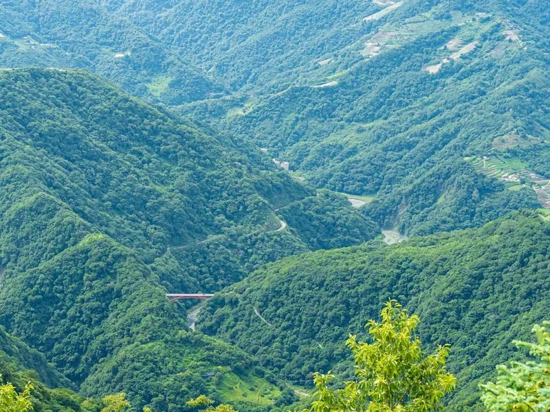
Yushan, or Jade Mountain, earns its name from the way its quartz-rich peaks are said to shimmer like precious jade when covered in winter snow or bathed in the silver light of a full moon. The trek to the summit is a masterclass in vertical biodiversity. Starting at the Tataka Trailhead (2,610 m), hikers begin their ascent through dense forests of Taiwan Hemlock and Japanese Blue Oak. As the trail winds upward, the air thins and the vegetation shifts to the iconic Yushan Cane and hardy alpine shrubs. The path is a feat of engineering, clinging to the side of precipitous cliffs with wooden boardwalks and stone-reinforced steps that provide safe passage through otherwise impassable terrain.
The journey is typically divided into two distinct phases. The first phase is the 8.5-kilometre trek from the trailhead to Paiyun Lodge (3,402 m). This section is a steady, manageable incline that allows for gradual acclimatisation. The second phase is the summit push—a 2.4-kilometre ascent from the lodge to the peak. This final stretch is where the "Challenging" rating is truly earned. The trail becomes a series of steep zigzags across scree slopes, culminating in the "Iron Tunnel"—a section of the ridge encased in metal cages to protect hikers from falling rocks and extreme winds. The final 200 metres require a hands-on scramble using fixed chains, leading to a summit that offers a 360-degree panorama of the Central Mountain Range, often rising above a sea of clouds (Unkai).
Because Yushan is a protected National Park and a site of immense ecological value, access is strictly controlled. The number of hikers permitted to stay at Paiyun Lodge is capped at approximately 116 per night, and the lottery system is notoriously competitive. This regulation ensures that the trail never feels overcrowded, preserving the sense of wilderness and solitude that makes the "Roof of Taiwan" so special. Whether you are standing at the Great Precipice watching the morning mist roll through the valleys or touching the summit stone as the sun rises over the Pacific, the Yushan Trail provides an emotional and physical experience that stays with a traveller for a lifetime.
History and Cultural Context
The history of Yushan is as layered as the geological strata of the mountain itself. To the indigenous Bunun people, the mountain is known as Tongku Saveq, a sacred place believed to be the ancestral home of their spirits and a sanctuary during a great primordial flood. The Bunun have lived in the shadow of these peaks for centuries, and their deep spiritual connection to the land is still felt today. For the Tsou people to the west, the mountain also holds significant cultural importance, marking the boundary of their traditional hunting grounds and ancestral territories.
During the Japanese colonial period (1895–1945), the mountain took on a new political and symbolic significance. Upon discovering that Yushan was higher than Mount Fuji, the Japanese renamed it Niitakayama, meaning "New High Mountain." It became a symbol of the expanding Japanese Empire, and a Shinto shrine was even established near the summit. The mountain gained international notoriety during World War II, as "Mount Niitaka" was used in the coded signal "Niitakayama Nobore" (Climb Mount Niitaka) to initiate the attack on Pearl Harbor. Following the return of Taiwan to Chinese rule, the mountain was renamed Yushan, reflecting its traditional Chinese name and its shimmering, jade-like appearance.
In the modern era, Yushan has become a symbol of Taiwan’s burgeoning environmental consciousness. Established in 1985, Yushan National Park was one of the first national parks in Taiwan, created to protect the unique alpine ecosystems and the diverse wildlife that calls the mountain home, including the Formosan Black Bear and the Formosan Serow. Today, the trail is a point of pride for the Taiwanese people, many of whom consider reaching the summit a "rite of passage." The transition from a colonial symbol to a protected natural treasure reflects Taiwan's own journey toward self-identity and environmental stewardship.
Want more background? Read extended notes on history and cultural context → Learn more
Seasonal Highlights and Weather Reality
The weather on Yushan is the most critical factor in determining the success and safety of a trek. Due to its height and position, the mountain experiences a wide range of microclimates, and conditions can shift from clear blue skies to dense fog and torrential rain within thirty minutes.
Autumn (October to November): This is widely considered the "Golden Season" for Yushan. The weather is at its most stable, with the highest probability of clear skies and the famous "sea of clouds" phenomenon. Temperatures are cool but manageable, and the autumn colours of the alpine flora provide a stunning backdrop for photography. This is also the most competitive time for permit applications.
Winter (January to March): During these months, Yushan becomes a true alpine environment. Snow is common, and the final scramble to the summit often requires crampons and ice axes. The National Park administration frequently implements "Snow Season" regulations, requiring hikers to prove they have alpine experience and proper equipment. While the snow-capped peaks are breathtaking, this is a period for experienced mountaineers only.
Spring (April to June): This is the season of renewal, as the Yushan Rhododendrons bloom in vibrant pinks and whites across the lower slopes. However, this period also coincides with the "Plum Rain" season, which can bring prolonged periods of dampness and fog, making the trail slippery and obscuring the views.
Summer (July to September): While temperatures are warm, summer is typhoon season in Taiwan. Heavy rains can lead to landslides and trail closures. If a typhoon warning is issued, the park is evacuated and all permits are cancelled. Hikers during this season should plan for afternoon thunderstorms and keep a close eye on the Central Weather Administration (CWA) reports.
Recommended Itinerary
2-Day Yushan Main Peak Itinerary
Day 1: Tataka Trailhead to Paiyun Lodge
- Distance: 8.5 km
- Elevation gain: 792 m
- Time: 4–6 hours
- Start at the Tataka Visitor Centre to check in and take the shuttle to the Tataka Trailhead (2,610 m).
- The trail begins with a gentle ascent through hemlock forests.
- Pass the Monroe Pavilion (2.7 km), a popular spot for a first break and a look at the eco-toilets.
- Continue to the Great Precipice (6.7 km), a massive rock face showing the geological folding of the mountain.
- The final 2 km to the lodge involve more consistent climbing but remain well-graded.
- Arrive at Paiyun Lodge (3,402 m) in the mid-afternoon to check in, arrange meals, and rest.
- Early dinner and sleep are essential, as the summit push begins well before dawn.
Day 2: Paiyun Lodge to Summit and Return to Trailhead
- Distance: 17.3 km (2.4 km to summit, 14.9 km return to trailhead)
- Elevation: 550 m gain to summit, 1,342 m descent to trailhead
- Time: 8–10 hours total
- Wake up at 2:00 AM for a light breakfast; depart the lodge by 3:00 AM.
- The trail climbs steeply through the forest before emerging onto the exposed alpine ridge.
- Navigate the "Iron Tunnel" (Wind Tunnel), using the metal structures for protection against the wind.
- The final 200 m is a steep scramble over rock and scree using fixed chains.
- Reach Yushan Main Peak (3,952 m) in time for sunrise. The views across the Central Mountain Range are unparalleled.
- Descend carefully back to Paiyun Lodge for a second breakfast or brunch.
- Pack up and begin the 8.5 km descent back to the Tataka Trailhead.
- Take the shuttle back to the visitor centre and begin the drive back to Chiayi.
Optional 3-Day Itinerary:
- For those who secure a two-night permit, Day 2 can be used to explore the North Peak (famous for the view of the Main Peak) or the West Peak (home to a small Japanese-era shrine).
- This allows for a much more relaxed pace and better acclimatisation, significantly reducing the risk of altitude sickness.
Important Notes:
- The shuttle from the visitor centre to the trailhead operates from 6:30 AM to 5:00 PM.
- Water is available at Paiyun Lodge, but it must be treated or boiled.
- The final scramble to the summit is highly exposed; if winds are too high, the park wardens may close the final section.
- Always carry a head torch with spare batteries for the pre-dawn summit push.
Planning and Bookings
Book Your Trip
Everything you need to plan your journey
Accommodation
Find places to stay near Chiayi City
Flights
Search flights to Chiayi City
Essential Preparation
The most significant hurdle for the Yushan Trail is not the physical climb, but the administrative process. Because the trail is located within a National Park and requires a stay at the limited-capacity Paiyun Lodge, planning must begin months in advance. Hikers must coordinate three things: the National Park Entry Permit, the Paiyun Lodge bed reservation, and the Police Mountain Permit. For international visitors, there is a specific "Foreigner Quota" that allows for easier booking on weekdays (Sunday to Thursday), but weekend spots are subject to the general lottery, which can have odds as low as 1 in 100 during peak season.
Physical preparation is equally vital. While the trail is well-maintained, the thin air at 3,900 metres makes every step feel twice as hard. Cardiovascular training, such as running or cycling, combined with weighted stair climbing, is highly recommended. If possible, spend a night at a mid-altitude location like Alishan (2,200 m) before starting the trek to help your body adjust to the elevation. Chiayi City is the primary gateway; ensure you have your transport to the Tataka Visitor Centre organised, as public buses are infrequent and private shuttles must be booked ahead of time.
Trail Accommodation
Accommodation on the Yushan Trail is centralised at Paiyun Lodge, a modern, two-storey facility managed by the National Park. There is no camping allowed anywhere on the main trail to the summit.
Paiyun Lodge Facilities:
- Bunk beds in shared dormitories (padded mats provided, but you must bring or rent a sleeping bag).
- Dining hall where pre-booked meals are served (breakfast, brunch, dinner).
- Indoor flushing toilets (no showers).
- Limited solar power for lighting (no charging outlets for hikers).
- Medical room with oxygen concentrators for emergency AMS treatment.
- Large outdoor deck for gear sorting and viewing the sunset.
What is NOT Provided:
- Bedding or pillows (sleeping bags can be rented in advance).
- Drinking water (only boiled water is provided during specific meal times; bring a filter for other times).
- Personal toiletries or towels.
- Rubbish bins (you must carry all your trash back down the mountain).
Booking and Costs:
- Lodge bed: NT$480 per night.
- Meals: Approximately NT$300–350 per meal (must be booked through a private contractor after securing the permit).
- Sleeping bag rental: Approximately NT$300 per night.
- The lottery for permits occurs 30 days before the hiking date. International hikers using the quota should apply 4 months to 35 days in advance.
Required Gear
- Footwear: Sturdy, waterproof hiking boots with good grip. The final scree slope is sharp and unstable.
- Clothing: A strict layering system is required. Base layers (merino wool), an insulating mid-layer (fleece or down), and a high-quality waterproof/windproof outer shell.
- Gloves: Essential for the final scramble. Durable work gloves or climbing gloves protect your hands from the cold metal chains.
- Head Torch: A powerful LED head torch with at least 200 lumens and spare batteries for the 3:00 AM start.
- Backpack: A 30–40L pack is usually sufficient if you are using the lodge's meal and sleeping bag services. Ensure it has a rain cover.
- Trekking Poles: Highly recommended to save your knees during the 1,300-metre descent on Day 2.
- Navigation: Downloaded offline maps (GPX) and a physical map. While the trail is marked, fog can make junctions confusing.
What to Bring
- Water: At least 2–3 litres of carrying capacity. A hydration bladder is useful for the steady climb, but a bottle is better for the summit push to prevent freezing.
- Snacks: High-energy, lightweight foods like nuts, dried fruit, energy gels, and chocolate. You will burn significantly more calories at altitude.
- Sun Protection: High-SPF sunscreen, lip balm with SPF, and polarised sunglasses. The UV radiation at 3,900 metres is intense, even on cloudy days.
- Personal First Aid: Include blister pads (Compeed), ibuprofen, and specifically, Diamox (Acetazolamide) if prescribed by your doctor for altitude sickness.
- Toiletries: Toothbrush, biodegradable wet wipes (for a "mountain shower"), and hand sanitiser.
- Identification: Your passport or ARC is mandatory for the check-in at the Tataka Police Station and the Paiyun Lodge.
- Cash: Small denominations of NTD for the trailhead shuttle (NT$100 each way) and any last-minute supplies at the visitor centre.
Permits
Securing permits for Yushan is often described as the most difficult part of the trek. There are two separate permits required: the National Park Entry Permit (which includes your lodge booking) and the Police Mountain Permit. The system is designed to prevent overcrowding and ensure hiker safety in the high-altitude environment.
The Lottery System:
- For the general public, permits are issued via a random lottery held 30 days before the trek date.
- Applications must be submitted through the Yushan National Park website between 7 and 30 days in advance.
- Weekends are extremely oversubscribed, often with thousands of applicants for just over 100 spots.
International Hiker Quota:
- To encourage international tourism, the park reserves 24 spots per day (Sunday to Thursday) for non-Taiwanese passport holders.
- These spots are allocated on a first-come, first-served basis rather than a lottery.
- Applications for the international quota open 4 months in advance and close 35 days before the trek. This is the most reliable way for visitors to secure a spot.
Police Mountain Permit:
- Once you have your National Park permit, you must apply for a Police Mountain Permit. This can be done online in advance or in person at the Shangritaka Police Station near the trailhead.
- You must carry a printed copy of both permits and your passport at all times while on the mountain.
Cancellations and "Last Minute" Spots: If you miss the lottery, check the "Cancellations" section of the official website daily. When someone cancels, their spot is released back into the system. You must be quick to grab these, as they disappear within seconds.
Other Activities in the Area
The region surrounding Yushan National Park offers a wealth of cultural and natural attractions that are perfect for pre-hike acclimatisation or post-hike relaxation:
- Alishan National Forest Recreation Area: Located just an hour from the Yushan trailhead, Alishan is famous for its sunrise over the sea of clouds, ancient giant cypress trees, and the historic forest railway. It sits at 2,200 metres, making it the ideal place to spend a night before your Yushan climb.
- Dongpu Hot Springs: After descending from the cold heights of Yushan, there is no better reward than soaking in the natural carbonic acid hot springs of Dongpu. This village is also the gateway to the Batongguan Historic Trail.
- Chiayi City Food Tour: Chiayi is the culinary heart of southern Taiwan. Don't miss the famous "Turkey Rice" (Huoji Rou Fan), a local specialty that provides the perfect carbohydrate-heavy recovery meal.
- Tataka Visitor Centre: Even if you aren't hiking to the summit, the area around the visitor centre offers several shorter trails, such as the Lulin Mountain and Linzhi Mountain loops, which provide spectacular views of the Yushan range without the need for a permit.
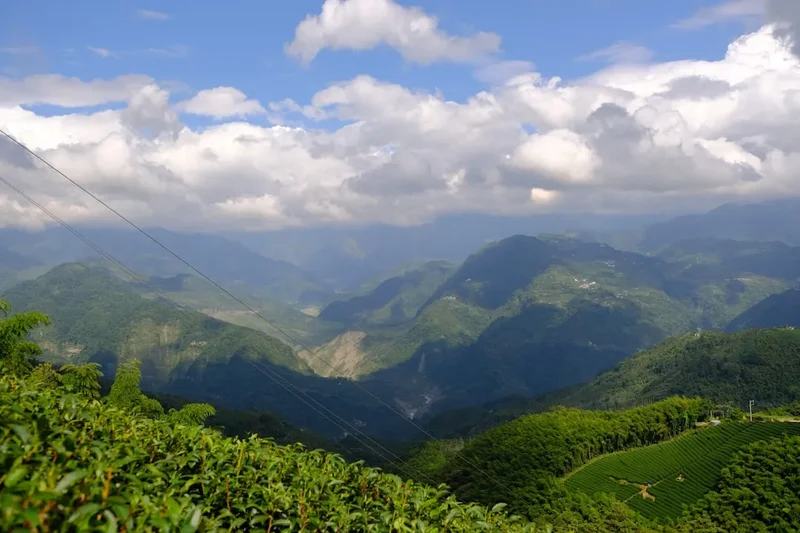
- Tea Tasting in Shizhuo: The high-altitude Oolong tea grown in the mountains around Yushan is world-renowned. Visit a local tea farm to learn about the processing and enjoy a traditional tea ceremony.
Safety and Conditions
Altitude Sickness (AMS): Acute Mountain Sickness is the primary safety concern on Yushan. Because the trail starts at 2,600 m and reaches nearly 4,000 m, many hikers experience symptoms such as headache, nausea, and dizziness. The key to prevention is "climbing high, sleeping low" (though difficult with the lodge's fixed location) and staying hydrated. If symptoms persist or worsen at Paiyun Lodge, the only cure is descent. Do not attempt the summit push if you are feeling unwell.
The Final Scramble: The last 200 metres to the summit are very steep and exposed. While there are chains to hold onto, the wind can be fierce. If you suffer from severe vertigo, this section may be challenging. In winter, this section is often covered in "verglas" (clear ice), making it extremely treacherous without crampons.
Weather Hazards: Hypothermia is a genuine risk, even in summer. Temperatures at the summit can be 20 degrees Celsius lower than at the trailhead, and wind chill can drop the perceived temperature below freezing. Always carry a dry set of clothes in a waterproof bag inside your pack. Lightning is also a concern during summer afternoon storms; if you hear thunder while on the exposed ridge, descend immediately.
Wildlife Encounters: While Formosan Black Bears are shy and rarely seen, they do inhabit the park. Store your food securely and never leave scraps near the trail. More common are the Formosan Macaques, which can be aggressive if they think you have food. Do not feed them or keep food in external mesh pockets of your backpack.
Emergency Services: There is limited mobile signal on the trail (mostly at specific "signal spots" marked with signs). In an emergency, dial 112. The park wardens at Paiyun Lodge are trained in mountain rescue, but a helicopter evacuation is dependent on clear weather and is not guaranteed.
Side Trips and Points of Interest
Yushan North Peak: For many photographers, the North Peak (3,858 m) is more important than the Main Peak. It offers the iconic "thousand-dollar view" of Yushan Main Peak (the view featured on the NT$1,000 note). It is also home to the highest weather station in Taiwan. The side trip adds about 4–5 hours to your Day 2 but is highly rewarding.
Yushan West Peak: A relatively easy 4-kilometre return trip from Paiyun Lodge. The trail is mostly through beautiful forest and leads to a small, well-preserved Japanese-era mountain shrine (Yamato-jinja). It is a peaceful alternative if the Main Peak is too crowded or if you have an extra afternoon at the lodge.
The Great Precipice: Located at the 6.7 km mark on the way to the lodge, this massive cliff face is a geological marvel. It consists of sedimentary rock that was once at the bottom of the ocean, now thrust nearly 3,500 metres into the air by the collision of the Eurasian and Philippine Sea plates. Look closely to see the ripple marks of ancient waves frozen in the stone.
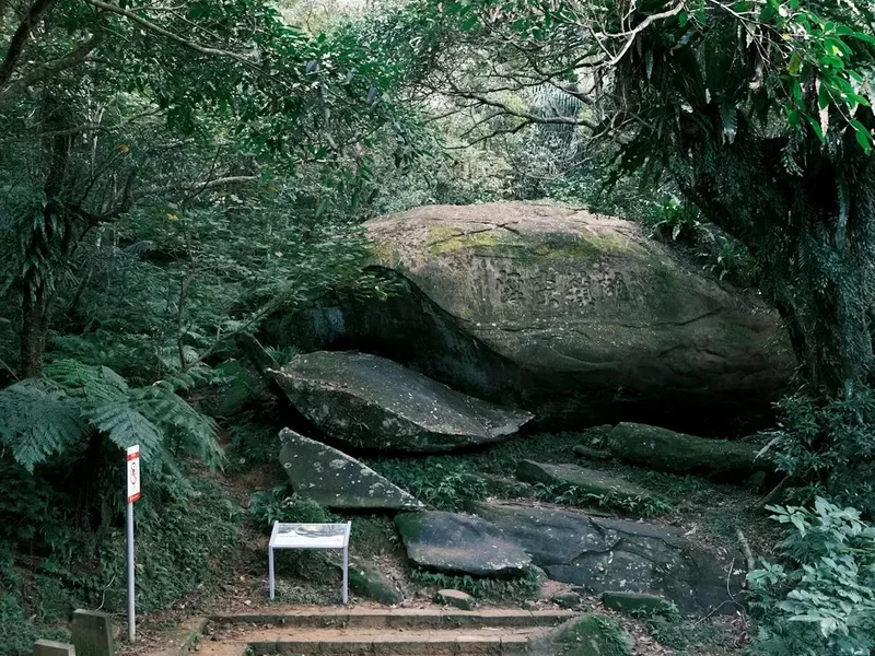
Monroe Pavilion: Named after a Chinese tax official who tragically fell to his death nearby in the early 20th century, this pavilion is now a safe and scenic rest stop. It marks the transition into the higher-altitude forest and is a great place to spot the endemic Taiwan Flamecrest or the Spotted Nutcracker.
Leave No Trace
Yushan National Park is a sanctuary for rare and endangered species, and its high-altitude environment is extremely slow to recover from human impact. Adhering to Leave No Trace (LNT) principles is not just a suggestion; it is a requirement for all permit holders.
Key LNT Practices for Yushan:
- Pack It In, Pack It Out: There are no rubbish bins on the trail or at Paiyun Lodge. Every piece of plastic, every fruit peel, and every cigarette butt must be carried back to the city.
- Respect the Wildlife: Do not feed the birds or macaques. Human food disrupts their natural diet and leads to aggressive behaviour.
- Stay on the Trail: The alpine tundra is composed of fragile mosses and lichens that can be destroyed by a single footstep. Shortcuts on switchbacks cause massive erosion during the rainy season.
- Proper Waste Disposal: Use the toilets provided at the trailhead, Monroe Pavilion, and Paiyun Lodge. If you must go between stations, use a "poop bag" and pack it out, or bury waste at least 20 centimetres deep and 50 metres from water sources.
- No Campfires: Fire is a major threat to the dry hemlock forests. Use only the designated cooking areas at the lodge with your own gas stove.
- Leave What You Find: Do not collect rocks, plants, or historical artefacts. Leave the "Jade" on the mountain for others to enjoy.