Yosemite Grand Traverse - The High Sierra Odyssey
The Yosemite Grand Traverse is a monumental high-altitude journey that spans approximately 105 kilometres through the rugged heart of California’s Sierra Nevada mountains. This is not merely a hike; it is a comprehensive immersion into the "Range of Light," as John Muir famously described it. Traversing from the remote southern boundaries of Yosemite National Park to the iconic granite cathedrals of the Yosemite Valley, the route encompasses a staggering 4,900 metres of elevation gain. It challenges walkers with high-alpine passes, pristine subalpine meadows, and some of the most famous geological formations on Earth. Unlike the more crowded John Muir Trail, the Grand Traverse offers a sense of profound isolation in its southern reaches before culminating in the breathtaking grandeur of the park’s most celebrated landmarks.
- Distance: 105.0 km point-to-point
- Duration: 7–10 days
- Season: July to September (strictly snow-dependent; high passes may remain blocked until mid-July)
- Accommodation: Wilderness camping (bear canisters mandatory; no permanent huts)
- Highest point: Post Peak Pass (3,231 m) or similar high-alpine crossings
- Difficulty: Very Challenging (requires high-altitude experience and off-trail navigation skills)
- Direction: Typically travelled south to north (Fernandez Trailhead to Yosemite Valley)
Overview
The Yosemite Grand Traverse represents the pinnacle of multi-day walking in the United States’ National Park system. It is a route designed for those who seek to understand the Sierra Nevada beyond the tourist-heavy valley floor. The journey begins in the Ansel Adams Wilderness or the southern reaches of Yosemite, where the landscape is defined by dense forests of red fir and lodgepole pine, eventually giving way to the stark, lunar beauty of the high-alpine zone. Here, the granite batholith that forms the backbone of the range is exposed in all its glory, carved by ancient glaciers into jagged peaks and deep, U-shaped canyons.
The scale of the landscape is difficult to overstate. Walkers will find themselves traversing vast plateaus where the horizon is a jagged line of 3,000-metre peaks, then descending into lush meadows where meandering streams provide habitat for rare alpine flora. The route is a masterclass in geological history, showcasing exfoliation domes, glacial erratics, and moraines that tell the story of millions of years of tectonic uplift and ice-age erosion. The air is thin and crisp, the light has a peculiar crystalline quality, and the silence of the high country is broken only by the whistle of a marmot or the rush of a distant waterfall.
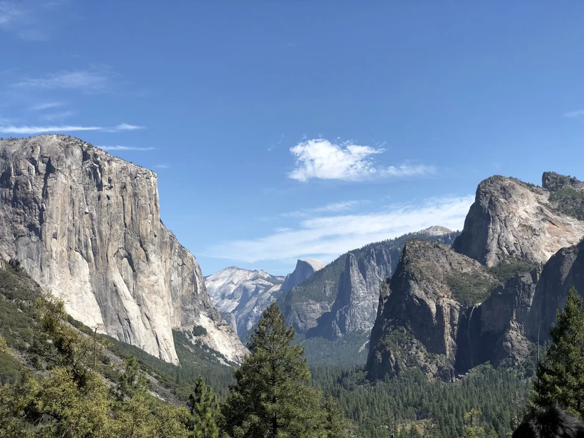
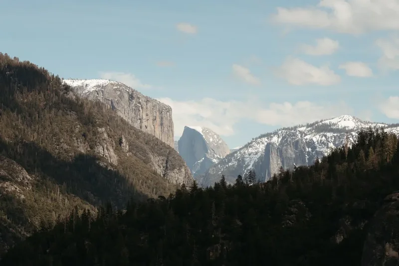
Physically, the Grand Traverse is a test of endurance and acclimatisation. The average elevation remains high, often staying above 2,500 metres for days at a time. This requires a slow, steady pace and a deep respect for the mountain environment. The rewards, however, are unparalleled: the sight of the sun setting over the Minarets, the reflection of Cathedral Peak in a still alpine tarn, and the final, triumphant descent into Yosemite Valley with Half Dome and El Capitan standing as silent sentinels. This is a journey that demands meticulous preparation but offers a spiritual and physical reward that stays with a walker for a lifetime.
History and Cultural Context
The history of the Yosemite Grand Traverse is inextricably linked to the indigenous peoples who first inhabited these mountains. For thousands of years, the Ahwahneechee (a branch of the Northern Paiute and Mono Lake Paiute) lived in and travelled through these valleys. They established complex trade routes over the high passes, exchanging acorns from the lower elevations for obsidian and salt from the eastern Sierra. To the Ahwahneechee, the Yosemite Valley was "Ahwahnee" (meaning "gaping mouth"), and the entire region was a sacred landscape deeply integrated into their spiritual and daily lives.
The mid-19th century brought a violent shift in the region's history. The Mariposa Battalion, a state-sponsored militia, entered the valley in 1851 during the Mariposa War, leading to the forced removal of the indigenous population. This period marked the beginning of European-American "discovery" and the subsequent romanticisation of the landscape. Figures like Lafayette Bunnell, the battalion's physician, were among the first to document the valley's wonders in English, though their presence was predicated on displacement.
In the late 1800s, the preservationist movement took root here, led by the Scottish-American naturalist John Muir. Muir’s tireless advocacy and his evocative writings about the "Range of Light" were instrumental in the establishment of Yosemite as a National Park in 1890. Muir, along with Joseph LeConte and other early members of the Sierra Club, explored the very routes that form the Grand Traverse today. They were followed by the "Buffalo Soldiers"—African American cavalry regiments who served as some of the first park rangers, patrolling the backcountry to prevent illegal grazing and timber theft. Today, walking the Grand Traverse is an act of following in the footsteps of these diverse historical figures, from the ancient indigenous traders to the early conservationists who fought to ensure this wilderness remained untamed.
Want more background? Read extended notes on history and cultural context → Learn more
Seasonal Highlights and Weather Reality
The window for completing the Yosemite Grand Traverse is narrow, dictated entirely by the winter snowpack. In heavy snow years, the high passes—such as Post Peak, Isberg, and Donohue—may remain impassable without technical ice axe and crampon skills until late July or even August. Conversely, in drought years, the route may open in June, but water sources can become scarce by late August.
July: The Season of Water and Life
Early July is a time of spectacular transformation. As the snow melts, the meadows erupt in a carpet of wildflowers—shooting stars, lupines, and mountain heather. Waterfalls are at their most thunderous, and the landscape is vibrant green. However, this is also peak mosquito season. The "Sierran Air Force" can be relentless in damp meadows, requiring head nets and strong repellent. Snow bridges may still exist over creeks, requiring careful assessment during crossings.
August: The Golden Window
August is generally considered the prime month for the Grand Traverse. The mosquitoes have largely subsided, the trails are clear of snow, and the weather is at its most stable. Days are warm (20–25°C), and nights are cool but rarely freezing at lower elevations. This is the best time for high-altitude photography, as the atmosphere is often clear, though smoke from regional wildfires can occasionally become a factor in late summer.
September: The Crisp Descent
September brings a sense of quiet to the high country. The light turns golden, the grasses in the meadows go to seed, and the first frosts begin to touch the subalpine zones. The weather is crisp and invigorating, though the risk of early-season snowstorms increases. Water management becomes more critical as smaller seasonal streams dry up. For many, the solitude and the lack of bugs make September the finest time to be in the Sierra.
Weather Reality: Regardless of the month, the Sierra Nevada is famous for its afternoon thunderstorms. These "monsoonal" events can build rapidly, bringing intense lightning, hail, and sudden temperature drops. Walkers must aim to be off high passes and exposed ridges by midday when clouds begin to tower. Hypothermia is a genuine risk even in summer if a walker is caught unprepared in a cold Sierra rain.
Recommended Itinerary
8-Day Yosemite Grand Traverse Itinerary
Day 1: Fernandez Trailhead to Lillian Lake
- Distance: 12 km
- Elevation gain: 750 m
- Time: 5–6 hours
- Start at the Fernandez Trailhead (outside the park boundary in the Ansel Adams Wilderness)
- Steady climb through mixed conifer forest of fir and pine
- Pass through the scenic Madera Creek drainage
- Camp at Lillian Lake (2,700 m), a stunning alpine lake tucked under the peaks of the Clark Range
- First night at altitude; focus on hydration and slow movement
Day 2: Lillian Lake to Post Peak Pass Area
- Distance: 14 km
- Elevation gain: 600 m
- Time: 6–7 hours
- Ascend toward the park boundary, leaving the forest for the granite high country
- Cross Post Peak Pass (3,231 m), the highest point of the journey
- Spectacular views south toward the Minarets and north into Yosemite’s wilderness
- Descend into the upper reaches of the Merced River headwaters
- Camp in the vicinity of the Pothole Meadows or upper Triple Peak Fork
Day 3: Triple Peak Fork to Lyell Canyon
- Distance: 16 km
- Elevation gain: 400 m
- Time: 7–8 hours
- Traverse the remote southeastern corner of Yosemite
- Cross Isberg Pass (3,190 m), another significant alpine crossing
- Descend through rugged granite basins and past hidden tarns
- Join the upper reaches of the Lyell Fork of the Tuolumne River
- Camp in the vast, glacial Lyell Canyon, surrounded by 3,500-metre peaks
Day 4: Lyell Canyon to Vogelsang
- Distance: 15 km
- Elevation gain: 550 m
- Time: 6–7 hours
- Walk the flat, meadowed floor of Lyell Canyon before beginning the climb to Vogelsang
- Pass through subalpine forests and past the Evelyn Lake junction
- Arrive at the Vogelsang area (3,100 m), the highest "High Sierra Camp" (though you will be wilderness camping)
- The landscape here is starkly beautiful, dominated by Fletcher Peak and Vogelsang Peak
- Explore the nearby Townley and Vogelsang Lakes
Day 5: Vogelsang to Cathedral Lakes
- Distance: 13 km
- Elevation gain: 300 m
- Time: 5–6 hours
- Descend from the Vogelsang plateau toward Tuolumne Meadows
- Cross the Tioga Road (the only road crossing on the traverse)
- Begin the ascent toward the iconic Cathedral Range
- Camp at Upper Cathedral Lake, situated directly beneath the spire of Cathedral Peak (3,326 m)
- One of the most photographed locations in the Sierra; sunset here is mandatory viewing
Day 6: Cathedral Lakes to Sunrise Lakes / Clouds Rest
- Distance: 14 km
- Elevation gain: 500 m
- Time: 6–7 hours
- Follow the John Muir Trail south toward Sunrise Meadows
- Climb the ridge toward the Clouds Rest junction
- Option to summit Clouds Rest (2,927 m) for the best 360-degree view in the park
- The view from Clouds Rest looks down onto the top of Half Dome
- Camp at the Sunrise Lakes or in the protected forest zones near the Clouds Rest shoulder
Day 7: Clouds Rest to Little Yosemite Valley
- Distance: 11 km
- Elevation loss: 900 m
- Time: 5–6 hours
- A long, knee-jarring descent from the high ridges toward the Merced River
- Pass through areas recovering from historic wildfires, offering unique ecological perspectives
- Arrive at Little Yosemite Valley (LYV), a popular backcountry camp
- Optional (if permit secured): Afternoon or early morning ascent of Half Dome via the cables
- Camp at the designated LYV sites near the river
Day 8: Little Yosemite Valley to Yosemite Valley
- Distance: 10 km
- Elevation loss: 600 m
- Time: 4 hours
- Descend the "Mist Trail" or the John Muir Trail
- Pass the thunderous Nevada Fall and Vernal Fall
- The transition from wilderness solitude to the bustling valley floor is a profound experience
- Finish at Happy Isles in Yosemite Valley
- Celebrate with a meal at Curry Village or the Yosemite Village Lodge
Important Notes:
- Wilderness permits are mandatory and must be secured via the lottery system.
- Bear canisters are required for all food storage; "hanging" food is not permitted.
- Water must be treated due to the presence of Giardia and other pathogens.
- The itinerary is flexible but depends heavily on finding suitable campsites with water.
- Always check the status of the Half Dome cables if planning that side trip.
Planning and Bookings
Book Your Trip
Everything you need to plan your journey
Accommodation
Find places to stay near El Portal, California
Flights
Search flights to El Portal, California
Essential Preparation
The Yosemite Grand Traverse requires a high level of physical fitness and logistical coordination. Walkers should be comfortable carrying a 15–20 kg pack for multiple days over steep, uneven terrain at altitudes exceeding 3,000 metres. Acclimatisation is key; spending 1–2 nights at a base town like El Portal (600 m) or, ideally, Tuolumne Meadows (2,600 m) before starting is highly recommended to prevent altitude sickness.
Logistically, the traverse is a point-to-point route. Most walkers fly into Fresno Yosemite International (FAT) and rent a car or use the YARTS (Yosemite Area Regional Transportation System) bus. Coordinating transport between the Fernandez Trailhead (south) and Yosemite Valley (north) can be complex. Many walkers use a two-car shuttle or hire a private shuttle service. El Portal serves as a primary gateway, offering hotels, basic supplies, and the last reliable mobile signal before entering the backcountry.
Trail Accommodation
Unlike European or New Zealand trails, the Yosemite Grand Traverse has no hut system for independent walkers. This is a pure wilderness experience requiring self-sufficiency.
Wilderness Camping:
- Walkers must camp in established sites or on durable surfaces (granite or pine needles) at least 30 metres from water and the trail.
- Little Yosemite Valley (Day 7) has designated sites with communal bear lockers and composting toilets.
- All other nights are spent in "dispersed" wilderness sites.
- No campfires are permitted above 2,900 metres (2,926 m) to protect fragile subalpine wood supplies.
- Costs: The wilderness permit itself carries a small fee (typically $10 per permit plus $5 per person), but there are no nightly camping fees in the backcountry.
What is NOT Provided:
- There are no shelters, huts, or permanent buildings along the route.
- No rubbish bins; you must pack out every scrap of waste.
- No treated water; all water must be filtered or boiled.
- No emergency communication; personal locator beacons (PLBs) are strongly advised.
Required Gear
- Bear Canister: An approved hard-sided container (e.g., BearVault, Garcia) is mandatory. It must fit all food, toiletries, and scented items.
- Footwear: Sturdy, broken-in tramping boots with excellent ankle support for granite talus and scree.
- Backpack: 55–75L capacity with a high-quality suspension system to handle the weight of a bear canister and 7+ days of food.
- Shelter: A lightweight, 3-season tent capable of withstanding high-alpine winds and heavy thunderstorms.
- Sleep System: A sleeping bag rated to at least -5°C. Even in August, temperatures at 3,000 metres can drop below freezing.
- Navigation: Topographic maps (Tom Harrison or National Geographic), a compass, and a GPS/offline map app (e.g., Gaia GPS).
- Clothing: A moisture-wicking base layer, an insulating mid-layer (down or synthetic puffer), and a high-quality waterproof shell.
What to Bring
- Food: High-calorie, lightweight dehydrated meals. Aim for 3,000–4,000 calories per day. Include plenty of salty snacks to replace electrolytes lost through sweat and altitude.
- Water Treatment: A reliable filter (e.g., Sawyer Squeeze or Katadyn BeFree) or chemical treatment (Aquamira).
- Sun Protection: SPF 50+ sunscreen, polarised sunglasses, and a wide-brimmed hat. The UV radiation at high altitude is intense.
- Insect Repellent: DEET or Picaridin, plus a head net for early-season mosquito protection.
- First Aid: Blister kits (Leukotape is excellent), ibuprofen, antihistamines, and any personal medications.
- Hygiene: A lightweight trowel for burying human waste, biodegradable soap, and a "WAG bag" if required in specific high-use zones.
- Power: A portable power bank (10,000–20,000 mAh) to keep navigation devices and cameras charged.
Permits
Securing a wilderness permit is the most significant hurdle for the Yosemite Grand Traverse. Yosemite National Park operates a strict quota system to protect the wilderness character of the backcountry. Permits are issued based on your starting trailhead.
The Lottery System:
- Permits are available via a weekly lottery on Recreation.gov 24 weeks (approximately 6 months) in advance.
- For a summer walk, you must apply in January or February.
- If you miss the lottery, remaining permits are released on a first-come, first-served basis on Recreation.gov.
- A small percentage of permits are held for "last-minute" release 7 days in advance.
Specific Requirements:
- Donohue Pass Quota: If your route includes crossing Donohue Pass (exiting Yosemite to the south or entering from the south), you must secure a specific "Donohue Pass" eligible permit. These are extremely competitive as they are shared with John Muir Trail hikers.
- Half Dome: A permit to hike the Grand Traverse does NOT automatically include Half Dome cables. You must specifically request the Half Dome permit as an add-on during your wilderness permit application, and it is subject to a separate quota.
- Group Size: Maximum group size is 15 people, though groups of 1–4 have a much higher chance of securing permits.
Strategy: Be flexible with your start dates and entry trailheads. Entering from the Ansel Adams Wilderness (US Forest Service) and walking into Yosemite can sometimes be easier than starting within the park, though you still need to coordinate with both agencies if crossing boundaries.
Other Activities in the Area
Yosemite and the surrounding Sierra Nevada offer a wealth of experiences for those with extra time:
- Rock Climbing: Yosemite is the world's premier climbing destination. While El Capitan is for experts, many guide services offer "intro to granite" classes in the valley or at Tuolumne Meadows.
- Mariposa Grove: Visit the southern end of the park to walk among the Giant Sequoias, some of the largest and oldest living organisms on Earth.
- Tioga Road Drive: One of the most scenic high-alpine drives in the world, offering access to Tenaya Lake and numerous shorter day hikes.
- Ansel Adams Gallery: Located in Yosemite Village, this gallery showcases the work of the famous photographer who helped immortalise the park’s landscapes.
- Rafting the Merced: In early summer, when the snowmelt is high, rafting through the valley offers a unique perspective on the towering cliffs.
- Biking the Valley: Rent a bicycle to explore the 19 kilometres of paved paths on the valley floor, a great way to see the sights without the traffic.
Safety and Conditions
Altitude Sickness: Much of the Grand Traverse takes place above 2,500 metres. Acute Mountain Sickness (AMS) can affect anyone, regardless of fitness. Symptoms include headache, nausea, and fatigue. The only cure is descent. Ascend slowly, stay hydrated, and avoid alcohol during the first few days.
Bears and Wildlife: Yosemite is home to a healthy population of American Black Bears. They are highly intelligent and have learned to associate humans with food. Use of a bear canister is non-negotiable. Never leave your pack unattended, and keep a "clean camp." If you encounter a bear, make noise, stand tall, and do not run. Rattlesnakes are also present at lower elevations; watch your step in rocky, sun-exposed areas.
River Crossings: In early summer, snowmelt can turn small creeks into dangerous torrents. Always unbuckle your pack's waist belt before crossing, wear shoes to protect your feet, and cross at the widest, shallowest point. If a crossing looks too dangerous, wait until early morning when meltwater levels are lowest, or find a fallen log upstream.
Lightning: The Sierra Nevada is prone to sudden afternoon thunderstorms. If you see "towering cumulus" clouds building, stay off ridges and peaks. If caught in a storm, find a low spot away from tall trees and metal objects, and crouch on your foam sleeping pad to insulate yourself from ground current.
Navigation: While the main trails are generally well-marked, snow cover in early summer or fire damage can make the path difficult to follow. Always carry a paper map and compass and know how to use them. Do not rely solely on a mobile phone, as batteries fail and screens can break.
Side Trips and Points of Interest
Half Dome: The ultimate Yosemite side trip. Rising 1,444 metres above the valley floor, the final ascent via the steel cables is a rite of passage. It requires a separate permit and nerves of steel. The view from the "Visor" is one of the most iconic in the world.
Mt. Lyell and the Lyell Glacier: For those with mountaineering experience, a detour to the base of Mt. Lyell (the highest point in Yosemite at 3,997 m) offers a chance to see the park's largest remaining glacier. It is a sobering look at the impacts of climate change in the high country.
Tenaya Lake: Often called the "Jewel of the High Sierra," this stunning alpine lake is easily accessible from the Tioga Road. It’s a perfect spot for a mid-trip swim (if you can brave the cold) and a picnic.
The Minarets: While technically just outside the park boundary in the Ansel Adams Wilderness, the jagged spires of the Minarets dominate the southern horizon for the first few days of the traverse. They represent some of the most dramatic alpine scenery in the entire Sierra Nevada.
Benson Lake: Known as the "Riviera of the Sierra," this remote lake in northern Yosemite (accessible via a longer variation of the traverse) features a wide, sandy beach that feels completely out of place in the rugged granite high country.
Leave No Trace
The Yosemite wilderness is a fragile ecosystem under immense pressure from high visitation. Practising Leave No Trace (LNT) principles is essential to ensure the "Range of Light" remains pristine for future generations.
Core Principles for the Sierra:
- Plan Ahead and Prepare: Know the regulations, carry the right gear, and be prepared for emergencies to avoid unnecessary rescues.
- Travel and Camp on Durable Surfaces: Stay on the trail. In the backcountry, camp on granite slabs or established dirt sites. Avoid crushing fragile alpine meadows.
- Dispose of Waste Properly: "Pack it in, pack it out." This includes orange peels, tea bags, and toilet paper. Use a trowel to bury human waste 15–20 cm deep, at least 60 metres from water.
- Leave What You Find: Do not pick wildflowers or remove rocks or artefacts. The "cultural landscape" includes indigenous obsidian flakes—leave them where they lie.
- Minimise Campfire Impacts: Use a lightweight stove for cooking. Fires are prohibited in many areas; check current fire restrictions at the ranger station.
- Respect Wildlife: Observe from a distance. Never feed animals, as this leads to "problem" bears that must eventually be euthanised.
- Be Considerate of Other Visitors: Keep noise levels down. Yield to uphill hikers and pack animals (mules and horses).
Useful Links
- Yosemite National Park - Wilderness Permits
- Recreation.gov - Yosemite Wilderness Lottery
- NPS - Bear Safety and Canister Requirements
- YARTS - Yosemite Area Regional Transportation System
- Eastern Sierra Weather and Conditions
- SierraWild.gov - Interagency Wilderness Information
- Pacific Crest Trail Association (for regional trail updates)