Wye Creek Track
The Wye Creek Track is a challenging yet rewarding day walk located near Queenstown, New Zealand. This route offers a steep ascent through native beech forest, culminating in spectacular panoramic views over Lake Wakatipu and the surrounding Southern Alps. It's a popular choice for those seeking a vigorous workout and a taste of Fiordland's dramatic landscapes without the commitment of a multi-day trek. The track is known for its consistent gradient, providing a good test of fitness, and its accessibility from Queenstown makes it a convenient option for visitors.
- Distance: 8.0 km return
- Elevation gain: 600 m
- Duration: 3-4 hours return
- Difficulty: Moderate to Hard (due to steepness)
- Season: Year-round, but best from October to April
- Closest City: Queenstown
- Trailhead Access: Drive south from Queenstown on State Highway 6 (Kingston-Queenstown Road) for approximately 20 minutes. Turn right onto Wye Creek Road. The road is sealed and leads directly to a small parking area at the trailhead.
- Permits: No permits are required for this walk.
- Coordinates: -45.0667, 168.6833
Overview
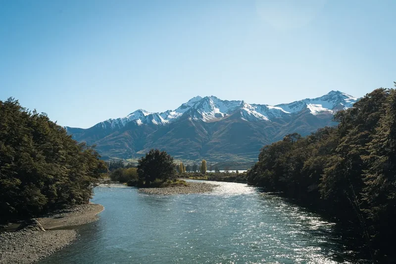
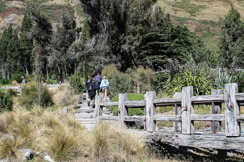
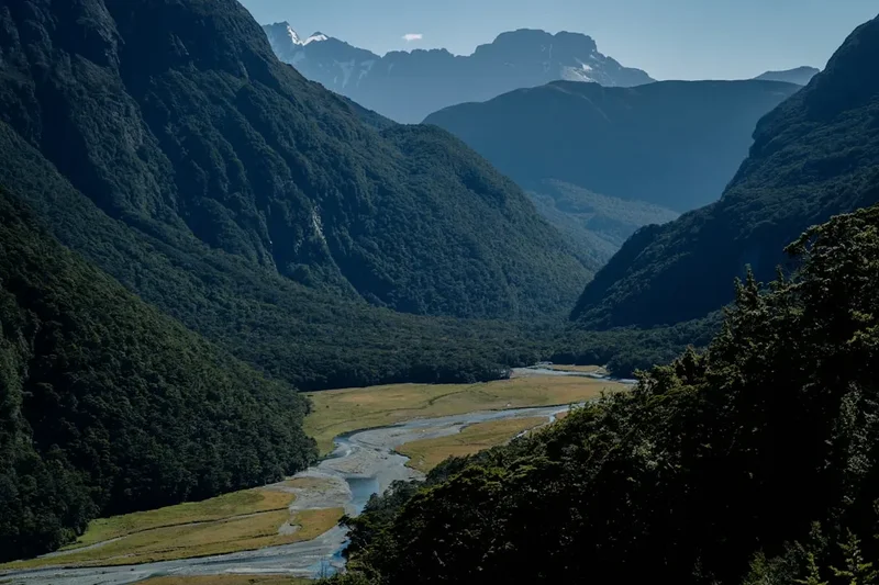
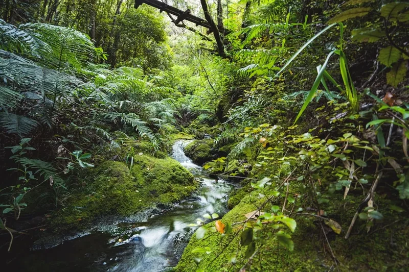
The Wye Creek Track is a quintessential Queenstown day hike, offering a substantial climb that rewards walkers with breathtaking vistas. The journey begins at the trailhead off Wye Creek Road, immediately plunging into a dense, mature beech forest. The path is well-formed but consistently steep, with numerous switchbacks designed to manage the significant elevation gain. As you ascend, the forest canopy gradually thins, offering tantalising glimpses of Lake Wakatipu through the trees. The air is crisp and clean, filled with the sounds of native birdsong and the gentle murmur of the creek that gives the track its name.
The climb is a steady, demanding effort, with the 600 metres of elevation gain packed into just 4 kilometres to the summit. This makes it an excellent option for those looking to improve their cardiovascular fitness or simply enjoy a strenuous workout amidst stunning natural beauty. The forest floor is often carpeted with moss and ferns, creating a lush, verdant environment that feels a world away from the bustling activity of Queenstown, which is surprisingly close.
Upon reaching the upper reaches of the track, the vegetation changes, and the views begin to open up dramatically. The final section leads to an open ridgeline, offering expansive, unobstructed panoramas. From this vantage point, you can survey the vast expanse of Lake Wakatipu, its deep blue waters stretching towards the horizon, framed by the majestic peaks of the Southern Alps. The Remarkables mountain range is particularly prominent, its jagged silhouette a constant and impressive backdrop. The descent follows the same path, offering a different perspective on the landscape as you re-enter the forest.
The Wye Creek Track is a popular choice for locals and visitors alike due to its accessibility, challenging nature, and the sheer quality of the views. It's a walk that can be completed in a few hours, making it ideal for a morning or afternoon excursion, and it provides a fantastic opportunity to experience the rugged beauty of the Queenstown-Lakes District.
History and Cultural Context
The Wye Creek area, like much of the Queenstown region, has a rich history tied to Māori exploration and later, European settlement and resource extraction. Before European arrival, Māori, particularly Ngāi Tahu, traversed these lands for hunting, gathering, and as part of seasonal routes. The dramatic landscapes of the Southern Alps and the shores of Lake Wakatipu hold deep cultural significance, with numerous pā sites and trails historically present in the wider area.
The development of the Wye Creek Track as a recreational trail is more recent, emerging as Queenstown grew into a major tourist destination. The area's proximity to the town and the stunning lake views made it an attractive location for developing walking tracks. The steep terrain presented a challenge for trail builders, requiring careful engineering to create a safe and sustainable route. The track's construction likely involved local authorities and volunteer groups focused on enhancing outdoor recreation opportunities for both residents and the burgeoning tourism industry.
The track's name, "Wye Creek," is likely derived from the shape of the creek itself or perhaps a surveyor's nomenclature. While not as historically significant as some of the Great Walks of New Zealand, the Wye Creek Track represents the ongoing effort to make the country's natural beauty accessible to a wider audience. It stands as a testament to the desire to balance conservation with recreation, providing a challenging yet achievable experience of the Fiordland-like landscapes that characterise the Queenstown region.
Seasonal Highlights and Weather Reality
The Wye Creek Track is accessible year-round, but the experience varies significantly with the seasons. The best time to undertake this walk is generally from October to April, during the warmer months when the weather is more predictable and the days are longer.
Spring (October–November): The landscape begins to awaken after winter. Native flora starts to bloom, and the native birdlife becomes more active. Snow may still linger on the higher peaks, adding a dramatic contrast to the emerging green of the forest. Weather can be changeable, with a mix of sunny days and rain showers.
Summer (December–February): This is the most popular time to walk the track. Days are long and generally warm, offering the best chance for clear skies and excellent visibility from the summit. However, summer also brings the highest risk of sandflies, particularly in shaded, damp areas. The forest is at its most lush and vibrant. Temperatures can reach the low 20s Celsius, but it's always wise to be prepared for cooler conditions at higher elevations.
Autumn (March–April): Autumn offers a spectacular display of colour as the beech forest transitions to shades of gold and russet. The weather is often stable with crisp, clear days and cooler temperatures, making for very pleasant walking conditions. Sandfly activity typically decreases. This is an excellent time for photography and a more tranquil walking experience.
Winter (May–September): While the track is technically open, winter conditions can make the Wye Creek Track challenging and potentially hazardous. Snow and ice can cover the track, especially on the steeper sections and at the summit. Visibility can be severely reduced by fog and low cloud. If attempting the walk in winter, appropriate winter hiking gear, including microspikes or crampons, and a good understanding of mountain weather are essential. The parking area may also be affected by snow.
Weather Considerations: Queenstown's weather is notoriously changeable. Even on a clear morning, conditions can deteriorate rapidly. Always check the local forecast before heading out, and be prepared for rain, wind, and cooler temperatures, regardless of the season. The summit area is exposed and can be significantly colder and windier than the trailhead.
Recommended Itinerary
Wye Creek Track - Day Walk Itinerary
Early Morning (Approx. 8:00 AM - 9:00 AM): Preparation and Departure
- Depart from Queenstown accommodation.
- Drive south on State Highway 6 for approximately 20 minutes.
- Turn right onto Wye Creek Road and drive to the trailhead parking area.
- Ensure you have all necessary gear, water, and snacks.
- Check the weather forecast one last time.
Morning (Approx. 9:00 AM - 11:00 AM): Ascent Through Forest
- Begin the walk at the Wye Creek trailhead.
- The track immediately enters dense native beech forest.
- Follow the well-marked but steep path, which consists of numerous switchbacks.
- Listen for native birdsong and enjoy the cool, shaded environment.
- Occasional breaks in the trees offer early glimpses of Lake Wakatipu.
- Distance covered: Approximately 2.0 km.
- Elevation gain: Approximately 200 m.
Midday (Approx. 11:00 AM - 12:30 PM): Reaching the Ridge and Summit Views
- Continue the steady ascent. The forest begins to open up more frequently.
- The gradient remains consistent, providing a good cardiovascular workout.
- As you gain altitude, the views of Lake Wakatipu and the surrounding mountains become more expansive and impressive.
- Reach the open ridgeline near the summit.
- Distance covered: Approximately 2.0 km (total 4.0 km).
- Elevation gain: Approximately 400 m (total 600 m).
- Time taken: Approximately 2-3 hours to reach the summit.
Afternoon (Approx. 12:30 PM - 2:00 PM): Summit Enjoyment and Descent
- Arrive at the highest point of the track.
- Spend time enjoying the panoramic 360-degree views of Lake Wakatipu, The Remarkables, and the surrounding mountain ranges.
- Have lunch or snacks and take photographs.
- Begin the descent, retracing your steps back down the track.
- The descent is quicker but requires care on the steep, sometimes loose sections.
- Distance covered: Approximately 4.0 km (total 8.0 km).
- Time taken: Approximately 1-1.5 hours for descent.
Late Afternoon (Approx. 2:00 PM onwards): Return to Trailhead
- Arrive back at the Wye Creek trailhead parking area.
- Allow time for stretching and rehydrating.
- Drive back to Queenstown.
Important Notes:
- This is a strenuous day walk due to the consistent steepness.
- Carry sufficient water (at least 1.5 litres per person) as there are no water sources on the track.
- Wear sturdy, supportive footwear.
- Be prepared for rapidly changing weather conditions.
- Sandflies can be present, especially during warmer months; bring insect repellent.
Planning and Bookings
Book Your Trip
Everything you need to plan your journey
Accommodation
Find places to stay near Queenstown
Flights
Search flights to Queenstown
Essential Preparation
The Wye Creek Track is a day walk, meaning no overnight accommodation bookings are required. However, essential preparation focuses on ensuring you have the right gear, understand the conditions, and are physically prepared for the steep ascent. Queenstown is the primary base town, offering a wide range of accommodation from budget hostels to luxury hotels. It's advisable to base yourself in Queenstown for easy access to the trailhead and other amenities. Ensure your vehicle is in good condition for the drive to the trailhead, as the Wye Creek Road is sealed but can be narrow in places. Familiarise yourself with the track's elevation gain and distance to gauge your fitness level. It's a moderate to hard walk due to the sustained climb.
Trail Accommodation
This is a day hike requiring no overnight accommodation.
Required Gear
- Sturdy hiking boots: Waterproof and with good ankle support are highly recommended due to the steep and sometimes uneven terrain.
- Backpack: A day pack (20-30 litres) is sufficient to carry essentials.
- Waterproof jacket: Essential for protection against rain and wind, which can change rapidly in the mountains.
- Warm layers: Even in summer, the summit can be cooler and windier. A fleece or thermal top is advisable.
- Sun protection: Hat, sunglasses, and sunscreen are important, especially on clear days when the sun can be intense at higher altitudes.
- Navigation: While the track is well-marked, a map or GPS device is always a good safety precaution. A downloaded offline map on your phone is also useful.
- First-aid kit: A basic kit with blister treatment, pain relievers, and any personal medications.
- Head torch: In case of unexpected delays, a head torch is essential for safe navigation in low light.
What to Bring
- Water: Carry at least 1.5 to 2 litres of water per person. There are no water sources on the track.
- Food: High-energy snacks and a packed lunch are recommended.
- Insect repellent: Sandflies can be prevalent, especially during warmer months and in shaded areas.
- Camera: To capture the stunning views.
- Trekking poles: Optional, but can be very helpful for managing the steep ascent and descent.
- Mobile phone: For communication in emergencies (note that reception can be patchy).
Permits
No permits are required to walk the Wye Creek Track. It is a public access track managed by the Department of Conservation (DOC) and local authorities, and there are no entry fees or booking systems in place for this day walk. Access to the trailhead is via a public road, and the track itself is open to all walkers.
Other Activities in the Area
Queenstown and its surroundings offer a vast array of activities for all interests:
- Hiking: Explore other local tracks such as the Queenstown Hill Time Walk, Ben Lomond Track (a more challenging multi-day option), or the Bob's Cove Track for a gentler lakeside stroll.
- Adventure Sports: Queenstown is the adventure capital of the world. Options include bungee jumping, skydiving, jet boating, white-water rafting, and canyoning.
- Lake Wakatipu Cruises: Take a scenic cruise on the historic TSS Earnslaw steamship or a modern catamaran to Walter Peak High Country Farm.
- Skiing and Snowboarding: During winter months (June-October), the nearby ski fields of Coronet Peak and The Remarkables offer excellent skiing and snowboarding opportunities.
- Wineries: The Gibbston Valley, a short drive from Queenstown, is renowned for its Pinot Noir and offers numerous cellar door experiences.
- Queenstown Gardens: Enjoy a leisurely walk through these beautifully maintained gardens on the peninsula, offering great views back towards the town.
- Onsen Hot Pools: Relax in private, cedar-lined hot pools overlooking the Shotover River canyon.
Safety and Conditions
Weather: The most significant safety consideration for the Wye Creek Track is the unpredictable mountain weather. Conditions can change rapidly, with rain, strong winds, and reduced visibility possible at any time, even on a clear day. Always check the MetService forecast for the Queenstown area and the specific mountain forecast if available before you depart. Be prepared to turn back if conditions deteriorate.
Terrain: The track is steep and can be slippery, especially after rain or in winter when ice may be present. Wear appropriate footwear with good grip. Take your time on the descent to avoid slips and falls.
Fitness: This is a moderately strenuous walk due to the significant elevation gain over a relatively short distance. Ensure you are adequately fit for the climb. If you have any health concerns, consult your doctor before undertaking the walk.
Water: There is no reliable water source on the track. Carry sufficient water for the entire duration of your walk (at least 1.5-2 litres per person). Dehydration can lead to fatigue and affect judgment.
Sandflies: Sandflies are common in the Queenstown area, particularly during warmer months and in shaded, damp environments. They can be a nuisance, so bring effective insect repellent containing DEET or picaridin.
Communication: Mobile phone reception can be patchy along the track, especially in the denser forest sections. Inform someone of your plans, including your expected return time.
Emergency: In case of an emergency, dial 111 (New Zealand emergency services) and ask for Police, Fire, or Ambulance as needed. Provide your location as accurately as possible.
Side Trips and Points of Interest
While the Wye Creek Track is primarily a single, direct route to a viewpoint, the journey itself offers several points of interest:
The Forest Environment: The track winds through a mature native beech forest. Take time to appreciate the diverse plant life, including various mosses, ferns, and lichens that thrive in the humid conditions. Listen for the calls of native birds such as the tūī, bellbird, and fantail, which are common in this habitat.
Lake Wakatipu Glimpses: As you ascend, the forest canopy opens up at various points, offering increasingly spectacular views of Lake Wakatipu. These intermittent viewpoints provide a preview of the grand panorama that awaits at the summit and are excellent spots for a brief rest and photo opportunity.
The Summit Viewpoint: The ultimate point of interest is the open ridgeline at the top of the track. This elevated position provides breathtaking 360-degree views. To the north and east, you'll see the iconic peaks of The Remarkables mountain range. To the south and west, Lake Wakatipu stretches out, with the town of Queenstown nestled on its shores. On a clear day, the visibility is exceptional, offering a true sense of the scale and beauty of the Southern Alps.
The Descent Perspective: The return journey offers a different perspective on the landscape. The familiar forest path looks new as you descend, and the views of the lake and mountains unfold in reverse, allowing for a final appreciation of the scenery.
Leave No Trace
The Wye Creek Track, like all natural areas, benefits from visitors adhering to Leave No Trace principles. These guidelines help minimise our impact and preserve the environment for future generations.
- Plan Ahead and Prepare: Know the track conditions, weather forecast, and your own capabilities. Pack appropriate gear and sufficient food and water.
- Travel and Camp on Durable Surfaces: Stick to the marked track at all times. Avoid walking on vegetation, especially the delicate mosses and ferns, which can be easily damaged and take a long time to recover.
- Dispose of Waste Properly: Pack out everything you pack in. This includes all food scraps, wrappers, and any other litter. Use the toilet facilities in Queenstown before you leave, or be prepared to carry out human waste if necessary (though this is generally not an issue for day walks).
- Leave What You Find: Do not remove any natural items such as rocks, plants, or flowers. Take only photographs and memories.
- Minimise Campfire Impacts: Campfires are not permitted on this track, and are generally discouraged in the Queenstown area due to fire risk.
- Respect Wildlife: Observe native birds and other wildlife from a distance. Do not feed them, as this can harm their health and alter their natural behaviour.
- Be Considerate of Other Visitors: Keep noise levels down, especially in the forest. Yield to uphill walkers. Share the track and the views respectfully.
By following these principles, you help ensure that the Wye Creek Track remains a beautiful and accessible natural asset for everyone to enjoy.