
Wrangell-St. Elias Traverse - The Great Alaskan Wilderness
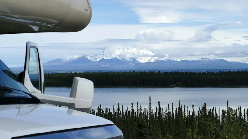
The Wrangell-St. Elias Traverse is not merely a hike; it is a profound expedition through the largest national park in the United States—a wilderness so vast it encompasses 5.3 million hectares of rugged mountains, massive glaciers, and untamed river valleys. This 160.9-kilometre journey represents the pinnacle of North American backcountry trekking, crossing the heart of a landscape where the Wrangell, St. Elias, and Chugach mountain ranges converge. Unlike traditional trails, the traverse is a route-finding challenge that demands total self-sufficiency, advanced navigation skills, and a deep respect for the raw power of the Alaskan subarctic. From the turquoise alpine waters of Tebay Lakes to the historic copper-mining relics of Kennecott, walkers will traverse high mountain passes, navigate sprawling ice fields, and ford glacial rivers in a region where humans are transient visitors and nature remains entirely sovereign.
- Distance: 160.9 km point-to-point
- Duration: 7–10 days
- Season: June to September (peak window is July and August)
- Accommodation: Remote wild camping only (no huts or established campsites)
- Elevation Gain: 6,096 m total ascent
- Difficulty: Very Challenging (requires expert navigation and river crossing skills)
- Access: Bush plane drop-off/pick-up typically required for logistics
Overview
The Wrangell-St. Elias Traverse is often described as "The Crown Jewel of the North," a title it earns through its sheer scale and the diversity of its terrain. This is a landscape of superlatives: it contains nine of the sixteen highest peaks in the United States, the largest sub-polar ice field in North America, and glaciers larger than entire European countries. The traverse itself is a masterclass in geological drama. It begins in the lush, lake-dotted basins of the Tebay region, where the greenery of the tundra provides a stark contrast to the jagged, snow-capped peaks of the Chugach Mountains. As the route progresses eastward, the vegetation thins, replaced by the monochromatic majesty of the Bremner and Monahan Glaciers—vast rivers of ice that have carved these valleys over millennia.
Walking here is a physical and psychological undertaking. There are no groomed paths, no signposts, and no bridges. Every kilometre must be earned through careful route selection, whether it is side-hilling on loose scree, bushwhacking through dense alder thickets, or finding the safest line across a braided glacial river. The weather is a constant, unpredictable factor; even in the height of summer, the region can experience freezing temperatures, torrential rain, and dense fog that can obscure landmarks for days. However, for those with the experience to manage these risks, the rewards are unparalleled. The silence of the Alaskan backcountry is absolute, broken only by the thunder of distant avalanches or the cry of a golden eagle. The sense of isolation is genuine, offering a rare opportunity to experience a landscape that remains largely unchanged since the last ice age.
The traverse concludes at the Kennecott Mines National Historic Landmark, a hauntingly beautiful collection of red wooden buildings perched on the edge of the Kennicott Glacier. This transition from total wilderness to the remnants of early 20th-century industrial ambition provides a poignant conclusion to the journey. It serves as a reminder of the brief, intense periods of human activity in a region that ultimately belongs to the ice and the mountains. For the modern trekker, completing the Wrangell-St. Elias Traverse is a transformative experience, a test of endurance and skill that leaves an indelible mark on the soul.
History and Cultural Context
The human history of the Wrangell-St. Elias region is a tapestry of indigenous resilience and short-lived industrial booms. For thousands of years, the Ahtna Athabascan people have inhabited the Copper River basin and the surrounding mountains. They developed a sophisticated culture perfectly adapted to the harsh subarctic environment, relying on seasonal migrations to hunt caribou, sheep, and moose, and to harvest salmon from the glacial rivers. The Ahtna were also skilled metalworkers, utilising the native copper found in the mountains long before European contact. Their deep spiritual connection to the land is reflected in the names of the peaks and rivers, many of which carry stories of ancestral journeys and mythological events.
The late 19th and early 20th centuries brought a wave of explorers and prospectors to the region, lured by the promise of mineral wealth. The discovery of incredibly rich copper ore in 1900 led to the development of the Kennecott Mines and the construction of the Copper River and Northwestern Railway—a feat of engineering that spanned 315 kilometres of treacherous terrain to connect the mines with the coastal port of Cordova. For nearly thirty years, Kennecott was one of the most productive copper mines in the world, a bustling industrial centre in the middle of the wilderness. When the ore was exhausted in 1938, the mines were abruptly abandoned, leaving behind the "ghost town" that trekkers encounter today. These preserved structures offer a fascinating glimpse into the lives of the miners and their families who laboured in this remote corner of the world.
In 1980, the passage of the Alaska National Interest Lands Conservation Act (ANILCA) established Wrangell-St. Elias National Park and Preserve, ensuring the protection of this extraordinary landscape. Today, the park is part of a massive international World Heritage site that includes Glacier Bay National Park in Alaska and Kluane National Park in Canada. This designation recognises the global significance of the region's natural and cultural values. As you walk the traverse, you are following in the footsteps of Ahtna hunters, intrepid prospectors, and early mountaineers, each of whom has contributed to the rich history of this formidable wilderness.
Want more background? Read extended notes on history and cultural context → Learn more
Seasonal Highlights and Weather Reality
The window for attempting the Wrangell-St. Elias Traverse is narrow, dictated by the extreme subarctic climate. June marks the beginning of the trekking season, as the snow begins to retreat from the lower valleys. This is a time of vibrant life, with wildflowers carpeting the tundra and long hours of daylight—up to 20 hours of sun—providing ample time for travel. However, June also brings high water levels in the rivers as the winter snowpack melts, making crossings particularly dangerous. Mosquitoes and "no-see-ums" also emerge in June, reaching their peak in early July; they are a significant factor that requires mental fortitude and high-quality head nets.
July and August are considered the prime months for the traverse. The high passes are generally clear of snow, and the river levels begin to stabilise, though they remain subject to sudden rises following rain or warm spells that increase glacial melt. The weather during this period is a mix of clear, brilliant days and periods of "Alaskan liquid sunshine"—a persistent, fine drizzle that can last for days. Temperatures typically range from 10°C to 20°C during the day, but can drop to near freezing at night, especially at higher elevations. This is also the best time for wildlife viewing, as bears are active in the valleys and Dall sheep can be seen on the high ridges.
September brings the arrival of autumn, a season of breathtaking beauty but increased risk. The tundra turns a brilliant palette of crimson, gold, and orange, and the first "termination dust" (snow) begins to coat the peaks. The mosquitoes disappear, and the air becomes crisp and clear. However, the days shorten rapidly, and the risk of significant snowstorms increases. By mid-September, the high passes may become impassable for those without mountaineering equipment. Winter arrives early and stays late; from October through May, the traverse is the domain of extreme cold, darkness, and deep snow, suitable only for highly specialised winter expeditions.
Recommended Itinerary

10-Day Wrangell-St. Elias Traverse Itinerary
Day 1: Tebay Lakes to Hanagita River
- Distance: 14 km
- Elevation gain: 450 m
- Time: 6–8 hours
- Drop-off by bush plane at Tebay Lakes (Upper or Lower)
- Begin the journey by navigating the lush tundra benches above the lakes
- Initial route-finding through willow thickets and over rolling ridges
- Descend toward the Hanagita River valley
- Establish first camp near the confluence of a clear-water tributary
- First taste of the "Alaskan bushwhack" in the lower elevations
Day 2: Hanagita River to Sangre De Cristo Creek
- Distance: 16 km
- Elevation gain: 600 m
- Time: 7–9 hours
- Follow the Hanagita River upstream, looking for game trails to ease progress
- First major river fording may be required depending on water levels
- Ascend toward the Sangre De Cristo range, a sub-range of the Chugach
- Terrain transitions from forest/shrub to open alpine tundra
- Camp in a high basin with views of the surrounding granite spires
- Keep a keen eye out for grizzly bears foraging in the valley floors
Day 3: Sangre De Cristo to Bremner Glacier Approach
- Distance: 15 km
- Elevation gain: 800 m
- Time: 8–10 hours
- Cross a high alpine pass (approx. 1,800 m) into the Bremner drainage
- Challenging descent over loose scree and talus slopes
- Navigate around hanging glaciers and steep rock walls
- The scale of the landscape begins to expand as the Bremner ice field comes into view
- Camp on a stable moraine near the edge of the glacier
- Water sources may be silty; look for clear snowmelt streams
Day 4: Crossing the Bremner Glacier
- Distance: 12 km
- Elevation gain: 300 m
- Time: 6–8 hours
- Travel on the "dry" ice of the lower Bremner Glacier (crampons/microspikes often necessary)
- Navigate around crevasses and moulins; rope may be required if snow cover is present
- Experience the surreal blue world of the glacier's surface
- Exit the glacier onto the southern lateral moraine
- Camp near the historic Bremner Mines area
- This is a physically demanding day requiring constant focus on footing
Day 5: Bremner Mines Exploration and Monahan Approach
- Distance: 8 km (plus exploration)
- Elevation gain: 400 m
- Time: 5–7 hours
- A shorter day to allow for exploration of the abandoned Bremner Gold Mine
- View historic machinery, cabins, and tunnels left from the 1930s
- Respect the site; do not remove any artefacts
- Afternoon move toward the Monahan Glacier drainage
- Camp in a sheltered spot before the next major glacier crossing
- Excellent opportunities for photography of the industrial ruins against the ice
Day 6: Monahan Glacier to Tana River Valley
- Distance: 18 km
- Elevation gain: 500 m
- Time: 9–11 hours
- A long, strenuous day crossing the Monahan Glacier
- Navigate complex moraines and ice-cored ridges
- Descend into the vast Tana River valley, one of the park's most remote areas
- The Tana is a massive, braided glacial river; scouting for a camp is crucial
- Camp on an elevated bench above the river to avoid flood risk
- The sense of isolation here is profound; you are deep in the wilderness
Day 7: Tana River to West Fork Nizina
- Distance: 20 km
- Elevation gain: 700 m
- Time: 10–12 hours
- Travel along the Tana River, navigating gravel bars and thick brush
- Ascend a steep ridge to bypass the Tana Canyon
- Cross into the West Fork Nizina drainage
- Terrain is a mix of alpine meadows and challenging "alder bashing"
- Camp near the headwaters of the West Fork
- This is often the "crux" day for endurance and mental resolve
Day 8: West Fork Nizina to Nizina Glacier
- Distance: 18 km
- Elevation gain: 600 m
- Time: 8–10 hours
- Follow the West Fork Nizina downstream toward the main glacier
- The valley opens up, offering views of the massive Nizina ice fall
- Navigate the complex terrain where the glacier meets the valley floor
- Camp on a high bench overlooking the Nizina Glacier
- Watch for ice calving from the distant hanging glaciers
- The scale of the ice here is difficult to comprehend
Day 9: Nizina Glacier to Kennicott River
- Distance: 22 km
- Elevation gain: 900 m
- Time: 10–12 hours
- A final push toward civilisation
- Navigate the lateral moraines of the Kennicott Glacier
- The route involves significant "side-hilling" on unstable slopes
- Pass through the "Gates" where the mountains pinch the glacier
- Camp near the edge of the Kennicott River, within sight of the mine buildings
- The first signs of human activity (old trails) may begin to appear
Day 10: Arrival in McCarthy/Kennecott
- Distance: 17.9 km
- Elevation gain: 796 m (various ups and downs)
- Time: 6–8 hours
- Follow the established trail from the glacier edge into Kennecott
- Walk through the historic mine site, marvelling at the 14-storey concentration mill
- Continue 7 km down the road (or take the shuttle) to the town of McCarthy
- Celebrate the completion of the traverse at the Golden Saloon
- Arrange for a shuttle or flight back to Glennallen or Anchorage
- Reflect on a journey through one of the world's last great wildernesses
Important Notes:
- This itinerary is a guide only; weather and river conditions will dictate your actual pace
- There are no marked trails; GPS and map/compass skills are mandatory
- Bear canisters are required for all food storage
- River crossings should only be attempted during low water (usually early morning)
- Emergency communication (InReach or Sat Phone) is essential
- Group size should be limited to 4–6 people to minimise impact
Planning and Bookings
Book Your Trip
Everything you need to plan your journey
Accommodation
Find places to stay near Glennallen
Flights
Search flights to Glennallen
Essential Preparation
Planning a traverse of Wrangell-St. Elias requires a level of logistical coordination far beyond a standard backpacking trip. The primary challenge is the "bush plane" logistics. Most trekkers fly from Glennallen or Chitina to a remote airstrip like Tebay Lakes and arrange a pick-up or finish at a location with road access like McCarthy. Coordinating these flights with air taxi operators (such as Wrangell Mountain Air or McCarthy Air) is the first step. You must provide them with your intended route and a "drop-dead" date for search and rescue purposes.
Physical preparation is equally critical. You will be carrying a pack weighing 20–25 kilograms over uneven, trackless terrain for 10 days. Training should focus on weighted hikes, core strength, and balance. Furthermore, you must be proficient in "Alaskan" skills: identifying safe river fords, navigating through dense brush, and managing encounters with grizzly bears. Glennallen serves as the primary base for supplies, though Anchorage is the best place to purchase specialised gear and bulk food before heading into the interior.
Trail Accommodation
There is no formal accommodation on the Wrangell-St. Elias Traverse. This is a pure wilderness experience requiring wild camping for the duration of the trip. There are no huts, no shelters, and no designated campsites. You are responsible for selecting safe, low-impact sites each night.
Camping Guidelines:
- Select sites on durable surfaces like gravel bars or dry tundra to avoid damaging vegetation
- Camp at least 100 metres away from water sources and bear travel corridors (like river banks)
- Use a "triangle" camp setup: sleep 100 metres from your cooking area, and store food in bear canisters another 100 metres away
- No fires are permitted in the backcountry; use a lightweight backpacking stove
- Be prepared for "dry camps" on ridges where water may be scarce
What is NOT provided:
- Everything. You must carry all shelter, bedding, and cooking equipment
- There are no toilets; you must follow "cat hole" procedures or pack out waste in sensitive areas
- There is no rubbish disposal; everything must be packed out
Required Gear
- Expedition Backpack - 70–85L capacity with a robust suspension system for heavy loads
- Four-Season Tent - Must be able to withstand high winds and heavy rain/snow
- Sleeping Bag - Rated to at least -5°C, even in summer; synthetic insulation is preferred due to moisture
- Sleeping Pad - High R-value for insulation from the cold ground or ice
- Mountaineering Boots - Stiff-soled, waterproof, and thoroughly broken in
- Crampons or Microspikes - Essential for glacier crossings and steep snow patches
- Navigation Kit - Topographic maps (1:63,360 scale), compass, and a GPS unit with spare batteries
- Satellite Communication - Garmin InReach or similar device for emergency contact
- Bear Canisters - Hard-sided containers (e.g., BearVault or Garcia) are mandatory for food storage
- River Crossing Shoes - Lightweight sneakers or dedicated wading boots with good grip
What to Bring
- Food for 10–12 days - High-calorie, lightweight dehydrated meals (include 2 days of emergency rations)
- Water Treatment - High-capacity filter (e.g., Katadyn) plus chemical backup (iodine or chlorine dioxide)
- Bear Spray - At least two canisters per group, carried in an accessible holster
- Clothing System - Merino wool base layers, fleece mid-layer, synthetic "puffy" jacket, and professional-grade hardshell (Gore-Tex)
- Head Net and Bug Repellent - High DEET concentration for mosquitoes and biting flies
- First Aid Kit - Comprehensive kit including blister care, trauma dressings, and broad-spectrum antibiotics
- Repair Kit - Duct tape, needle/thread, sleeping pad patches, and stove maintenance tools
- Sun Protection - SPF 50+ sunscreen, polarised sunglasses (crucial for glacier travel), and a wide-brimmed hat
- Personal Hygiene - Biodegradable soap, trowel, toilet paper, and hand sanitiser
- Power Bank - Large capacity (20,000mAh+) to keep GPS and communication devices charged
Permits
One of the unique aspects of Wrangell-St. Elias National Park is that no formal permits are currently required for backcountry travel. There are no quotas and no fees for camping in the wilderness. However, this lack of regulation places a higher burden of responsibility on the trekker to be self-reliant and prepared.
Backcountry Registration:
- While not mandatory, the National Park Service (NPS) strongly encourages all trekkers to complete a Backcountry Itinerary at the Visitor Centre in Copper centre or the Slana Ranger Station
- This registration provides rangers with your route, group size, and expected return date, which is vital information in the event of a search and rescue operation
- You can also receive up-to-date information on river conditions, bear activity, and glacier changes during the registration process
Regulations and Requirements:
- Bear Canisters: The use of NPS-approved bear-resistant food containers is mandatory throughout the park's backcountry
- Group Size: To preserve the wilderness character and minimise environmental impact, group sizes are generally limited to 12 people, though smaller groups (4–6) are recommended for this specific traverse
- Aviation: If using an air taxi, ensure they are an NPS-authorised concessionaire. Landing permits for private aircraft are subject to specific park regulations
Costs:
- Park Entry: There is no entrance fee for Wrangell-St. Elias National Park
- Air Taxi: This is the most significant cost, typically ranging from US$500 to US$1,500 per person depending on the group size and flight distance
- Accommodation in McCarthy: If staying in the town before or after your hike, expect to pay US$150–US$300 per night for lodges
Other Activities in the Area
The Wrangell-St. Elias region offers numerous ways to experience the landscape beyond the main traverse:
- Kennecott Mill Tours: Take a guided tour of the 14-storey concentration mill to learn about the incredible engineering and difficult lives of the copper miners.
- Root Glacier Hiking: For those with less time, a day hike from Kennecott onto the Root Glacier provides a spectacular introduction to glacier travel with minimal equipment.
- Ice Climbing: Local guide services in McCarthy offer introductory and advanced ice climbing courses on the nearby glaciers.
- Flightseeing: If the traverse seems too daunting, a flightseeing tour provides a bird's-eye view of the massive ice fields, 5,000-metre peaks, and hidden valleys.
- Rafting the Nizina River: Experience the power of glacial meltwater by rafting from the Nizina Glacier down to the Chitina River—a world-class whitewater adventure.
- Photography Workshops: The unique light and dramatic scale of the park make it a premier destination for landscape and wildlife photographers.
Safety and Conditions
River Crossings: This is the single greatest hazard on the traverse. Glacial rivers are cold, silty (making it impossible to see the bottom), and extremely powerful. Always scout for the widest, most braided section of the river. Cross in the early morning when meltwater is at its lowest. Use the "triangle" method for groups or a sturdy pole for individuals. If in doubt, do not cross; wait for water levels to drop or find an alternative route.
Bear Safety: Wrangell-St. Elias is home to both black bears and grizzly (brown) bears. Encounters are common. Make noise while travelling, especially in dense brush or near rushing water. Carry bear spray in an accessible location and know how to use it. Store all food, rubbish, and scented items in bear canisters. If you see a bear, stay calm, identify yourself as human by speaking in a low voice, and slowly back away. Never run.
Glacier Travel: Crossing the Bremner and Monahan Glaciers requires knowledge of crevasse rescue and ice navigation. Even "dry" glaciers can have hidden hazards. Use crampons for traction and be wary of "snow bridges" that may conceal deep fissures. If you are not experienced in glacier travel, consider hiring a guide for these sections or taking a specialised course before your trip.
Weather and Hypothermia: Hypothermia is a year-round risk in Alaska. Wet, windy conditions at 10°C can be more dangerous than dry cold at -10°C. Always have your hardshell layers accessible. Monitor group members for signs of the "umbles" (stumbling, mumbling, fumbling), which indicate early-stage hypothermia. Carry a high-calorie snack and a warm drink to boost core temperature.
Emergency Communication: There is no mobile phone coverage in the park. A satellite communication device (InReach, Zoleo, or Sat Phone) is mandatory. Ensure you have the contact numbers for the NPS Dispatch and your air taxi operator programmed into the device.
Side Trips and Points of Interest
The Bremner Gold District: Located in the middle of the traverse, this historic district contains the remains of several gold mines from the 1930s. The Lucky Girl Mine and the Yellow Band Mine feature remarkably preserved cabins, rusted machinery, and even old bunkhouses. It is a surreal experience to find these industrial relics in such a remote, high-alpine setting. Spend an extra half-day here to soak in the history and imagine the effort required to transport equipment to this location.
Tebay Lakes Fishing: If you have a valid Alaskan fishing licence, the Tebay Lakes offer excellent opportunities for catching rainbow trout and lake trout. The crystal-clear waters are a stark contrast to the silty glacial rivers found elsewhere on the route. It is a perfect place to spend an extra day at the beginning of your trip to acclimatise and enjoy the scenery.
Hanagita Valley Wildlife Viewing: This broad, U-shaped valley is a major corridor for wildlife. It is one of the best places in the park to spot caribou herds during their seasonal migrations. The open terrain also makes it easier to spot grizzly bears and wolves from a safe distance. Bring a good pair of binoculars and spend time glassing the slopes in the early morning and late evening.
The Nizina Icefall: As you approach the end of the traverse, the Nizina Glacier provides a spectacular display of glaciological power. The icefall, where the glacier tumbles over a steep rock step, creates a chaotic landscape of massive seracs and deep blue crevasses. While too dangerous to enter, the viewpoints from the surrounding ridges are some of the most dramatic in the entire park.
Leave No Trace

The Wrangell-St. Elias wilderness is a fragile ecosystem where the scars of human impact can last for centuries. The short growing season means that trampled tundra may take decades to recover. As a visitor to this pristine environment, you have a moral and legal obligation to follow Leave No Trace principles to the highest standard.
Key Principles for the Traverse:
- Travel on Durable Surfaces: In the alpine, stick to rock, gravel, or snow whenever possible. If you must walk on tundra, spread out your group to avoid creating a "social trail" that others might follow.
- Dispose of Waste Properly: Use "cat holes" at least 15 centimetres deep and 100 metres from water. In glacial or high-alpine areas where soil is absent, you must pack out all human waste using "WAG bags."
- Leave What You Find: This is especially important at historic sites like the Bremner Mines. Do not move or remove any artefacts, no matter how small. They are part of the collective history of the park.
- Minimise Campfire Impacts: Use a stove for all cooking. Campfires are discouraged as they leave permanent scars and consume scarce wood that provides vital habitat for insects and birds.
- Respect Wildlife: Observe animals from a distance. If an animal changes its behaviour because of your presence, you are too close. This is particularly important for bears and nesting birds.
By following these guidelines, you ensure that the Wrangell-St. Elias Traverse remains a true wilderness for those who follow in your footsteps. Leave only footprints, take only photographs, and keep the wild, wild.