Mount Rainier Wonderland Trail - The Ultimate Alpine Circumnavigation
The Wonderland Trail is a legendary 150-kilometre trekking route that completely encircles Mount Rainier (Tahoma), an active stratovolcano and the most glaciated peak in the contiguous United States. Located within Mount Rainier National Park in Washington State, this trail is widely considered one of the most beautiful and physically demanding thru-hikes in North America. The journey takes hikers through a staggering diversity of ecosystems, from ancient lowland temperate rainforests and roaring glacial rivers to subalpine meadows bursting with wildflowers and high-altitude volcanic barrens. With a cumulative elevation gain of approximately 6,700 metres, the trail is a relentless "rollercoaster" of steep climbs and descents, crossing every major ridge and valley that radiates from the mountain's icy summit. This is not merely a walk; it is a profound immersion into a landscape defined by fire and ice, requiring meticulous planning, physical resilience, and a deep respect for the unpredictable mountain environment.
- Distance: 150.0 km (approximate loop)
- Duration: 9–14 days
- Season: Late July to early September (snowmelt dependent)
- Campsites: 18 designated backcountry camps (mandatory permits)
- Highest point: Panhandle Gap (2,073 m)
- Total Elevation Gain: Approximately 6,700 m
- Direction: Can be hiked clockwise or anticlockwise (clockwise is most common)
Overview
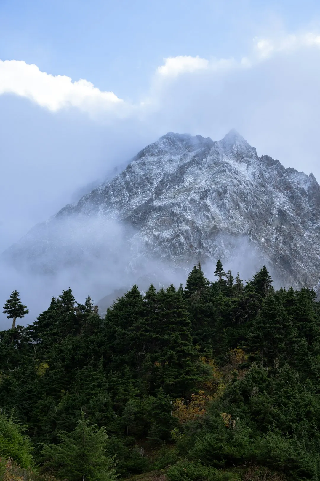
The Wonderland Trail is defined by its relationship with the mountain it encircles. Mount Rainier, standing at 4,392 metres, creates its own weather systems and dominates the horizon from every angle of the trail. However, the experience of the Wonderland is not one of looking at the mountain from afar, but of moving through its very foundations. The trail was designed to showcase the park's immense variety, and it succeeds by forcing hikers to descend into deep, humid river valleys before climbing back up to high alpine passes, often multiple times in a single day. This constant change in elevation means that within a few hours, a hiker can transition from the shade of 1,000-year-old Douglas firs to the stark, wind-swept beauty of a glacial moraine.
The terrain is notoriously rugged. The path is well-maintained but often consists of steep switchbacks, rocky traverses, and exposed ridgelines. One of the most iconic features of the Wonderland is its river crossings. Because the trail crosses every drainage coming off the mountain, hikers must navigate numerous glacial rivers—such as the Carbon, Nisqually, and White Rivers—via log bridges or suspension bridges. These rivers are milky with "glacial flour" (finely ground rock) and can become roaring torrents during periods of heavy rain or rapid snowmelt, adding an element of raw wilderness power to the journey.
For many, the highlight of the trail is the subalpine meadows. In late July and August, areas like Indian Henry’s Hunting Ground, Summerland, and Spray Park transform into vibrant tapestries of lupine, paintbrush, and avalanche lilies. These meadows are fragile and ephemeral, existing in a brief window between the melting of the winter snows (which can reach depths of 20 metres) and the arrival of the first autumn frosts. Walking through these fields with the massive, creaking glaciers of Rainier looming overhead is an experience that stays with a hiker forever. Due to its popularity and the strict permit system, the Wonderland Trail offers a sense of solitude that is increasingly rare in the modern world, allowing for a deep, meditative connection with one of the world's great natural wonders.
History and Cultural Context
The land surrounding Mount Rainier, known as Tahoma or Tacobet to indigenous peoples, has been of profound spiritual and practical importance for millennia. At least six contemporary tribes—the Nisqually, Puyallup, Squaxin Island, Muckleshoot, Yakama, and Cowlitz—maintain deep ancestral connections to the mountain. For these peoples, the mountain was a place for hunting, gathering berries, and seeking spiritual visions. The high meadows were seasonal homes where families would gather to harvest the bounty of the subalpine summer. The mountain itself is often personified in indigenous oral traditions as a powerful female deity, a source of life-giving water and a sentinel over the Salish Sea region.
European exploration and the subsequent push for conservation led to the establishment of Mount Rainier National Park in 1899, making it the fifth national park in the United States. The concept of a trail encircling the mountain began to take shape in the early 20th century. In 1915, the trail was officially named the "Wonderland Trail" by park officials who recognised its potential as a world-class tourist attraction. Much of the early construction was carried out by the National Park Service, but the trail as it exists today owes a great deal to the Civilian Conservation Corps (CCC) during the 1930s. These workers built many of the stone shelters, bridges, and the durable tread that still carries hikers across the rugged terrain today.
The trail has evolved from a route used by early rangers on horseback to a premier destination for modern thru-hikers. In 1981, the park implemented a wilderness permit system to protect the fragile subalpine ecosystems from the impacts of increasing foot traffic. Today, the Wonderland Trail is managed with a focus on "minimum tool" ethics and wilderness preservation, ensuring that the historical and natural character of the route remains intact for future generations. Hikers today walk in the footsteps of both ancient indigenous gatherers and early 20th-century explorers, contributing to a long history of human interaction with this formidable volcanic landscape.
Want more background? Read extended notes on history and cultural context → Learn more
Seasonal Highlights and Weather Reality
The window for hiking the Wonderland Trail is remarkably short due to the massive amounts of snow the mountain receives. Even in years with average snowfall, many of the high passes (such as Panhandle Gap and Spray Park) remain buried under snow until mid-to-late July. Attempting the trail before the snow has melted requires advanced navigation skills and the ability to traverse steep, icy slopes.
Late July to Mid-August: This is the "prime" season. The wildflowers are at their peak, the days are long, and the biting insects (mosquitoes and black flies), while present, begin to subside. This is also the period of highest demand for permits. Temperatures can range from 25°C in the valleys to near freezing at night in the high camps. Hikers should be prepared for "mountain weather"—sudden thunderstorms and thick fog can roll in even on a forecast clear day.
Late August to Early September: This is often considered the best time by experienced hikers. The bugs are largely gone, the huckleberries are ripe for picking, and the autumn colours begin to touch the vine maples and grasses. The weather is generally more stable, though the days are shorter and the nights are noticeably colder. By mid-September, the risk of the first major autumn snowstorm increases significantly, which can effectively end the hiking season for those without winter gear.
The "Rainier Factor": Regardless of the season, Mount Rainier creates its own microclimate. It is not uncommon for the mountain to be shrouded in "the mountain is out" (clear) weather while the surrounding valleys are trapped in a thick marine layer of clouds. Conversely, the mountain can attract and hold storm systems while the rest of Washington remains dry. Hikers must be prepared for rain at any time; the western side of the park, in particular, receives significantly more precipitation than the eastern side.
Recommended Itinerary
10-Day Wonderland Trail Itinerary (Clockwise)
Day 1: Longmire to Devil's Dream
- Distance: 11.5 km
- Elevation gain: 850 m
- Time: 4–5 hours
- Start at the historic Longmire district (842 m)
- Steady climb through old-growth forest
- Pass the spectacular Kautz Creek mudflow area
- Arrive at Devil's Dream Camp (1,542 m)
- Note: This camp is notorious for mosquitoes in early summer; bring a head net
Day 2: Devil's Dream to North Puyallup River
- Distance: 18.5 km
- Elevation: 600 m gain, 900 m loss
- Time: 7–8 hours
- Cross the stunning Indian Henry’s Hunting Ground with its historic ranger cabin
- Descend steeply to the Tahoma Creek suspension bridge (one of the highest on the trail)
- Climb over Emerald Ridge for breathtaking views of the Tahoma Glacier
- Descend to North Puyallup River Camp (1,143 m) located near a dramatic waterfall
Day 3: North Puyallup River to Golden Lakes
- Distance: 8 km
- Elevation gain: 550 m
- Time: 3–4 hours
- A shorter day to allow for recovery or exploration
- Steady climb out of the Puyallup canyon
- Traverse through subalpine forest and small meadows
- Arrive at Golden Lakes Camp (1,554 m), a series of beautiful tarns that glow at sunset
- Excellent spot for photography and swimming on warm days
Day 4: Golden Lakes to Mowich Lake
- Distance: 16.5 km
- Elevation: 700 m gain, 800 m loss
- Time: 6–7 hours
- Long descent to the South Mowich River (often a challenging river crossing)
- Stiff climb up to the Mowich Lake plateau
- Arrive at Mowich Lake (1,502 m), the largest and deepest lake in the park
- Note: This is a front-country campground with road access; a great spot for a pre-arranged food cache
Day 5: Mowich Lake to Carbon River (via Spray Park)
- Distance: 13.5 km
- Elevation: 750 m gain, 1,100 m loss
- Time: 6–7 hours
- Take the "Spray Park" alternate route (highly recommended over the forested main trail)
- Pass Spray Falls, a 100-metre veil of water
- Climb into the vast alpine meadows of Spray Park (highest point 1,950 m)
- Descend steeply past the Carbon Glacier, the lowest-reaching glacier in the lower 48 states
- Arrive at Carbon River Camp (975 m)
Day 6: Carbon River to Mystic Lake
- Distance: 13 km
- Elevation gain: 850 m
- Time: 5–6 hours
- Cross the Carbon River suspension bridge
- Long, steady climb up to Moraine Park with views of the Willis Wall
- Arrive at Mystic Lake (1,737 m), a jewel-like lake nestled under the mountain
- The Mystic Lake patrol cabin is a classic example of park architecture
Day 7: Mystic Lake to Sunrise/White River
- Distance: 14.5 km
- Elevation: 500 m gain, 800 m loss
- Time: 5–6 hours
- Descend to the Winthrop Glacier and cross the West Fork White River
- Climb to Skyscraper Pass for expansive views of the northern park
- Descend into the Sunrise area, the highest point reachable by car in the park
- Stay at White River Campground (1,341 m)
- Note: Another excellent location for a food cache
Day 8: White River to Summerland
- Distance: 11 km
- Elevation gain: 650 m
- Time: 4–5 hours
- Climb steadily through forest alongside Fryingpan Creek
- Enter the Summerland meadows, widely considered the most beautiful spot on the trail
- Arrive at Summerland Camp (1,810 m)
- The stone group shelter here is a historic CCC structure
Day 9: Summerland to Indian Bar
- Distance: 7.5 km
- Elevation: 450 m gain, 550 m loss
- Time: 4–5 hours
- The most spectacular high-altitude section of the trail
- Cross Panhandle Gap (2,073 m), the highest point on the Wonderland Trail
- Traverse snowfields and rocky barrens with views of Mount Adams and Mount St. Helens
- Descend into the Ohanapecosh Park and finally into the Indian Bar basin
- Arrive at Indian Bar Camp (1,560 m), located in a stunning glacial cirque with multiple waterfalls
Day 10: Indian Bar to Longmire
- Distance: 27.5 km
- Elevation: 600 m gain, 1,300 m loss
- Time: 9–11 hours
- A very long final day (can be split by staying at Nickel Creek or Snow Lake)
- Climb out of Indian Bar to the Cowlitz Divide
- Long descent to Box Canyon (a narrow, 55-metre deep slot canyon)
- Climb past Reflection Lakes with their iconic views of the mountain
- Final descent back to Longmire to complete the loop
Planning and Bookings
Book Your Trip
Everything you need to plan your journey
Accommodation
Find places to stay near Seattle, Washington
Flights
Search flights to Seattle, Washington
Essential Preparation
The Wonderland Trail requires a level of fitness and logistical planning far beyond a standard weekend hike. Because of the "rollercoaster" elevation profile, hikers should train with a weighted pack on steep terrain for several months prior to their start date. Leg strength and cardiovascular endurance are critical for the 6,700 metres of total ascent.
Logistically, you must decide on your starting point. Longmire, Mowich Lake, and White River are the three main access points where you can park a car and pick up permits. Most hikers fly into Seattle-Tacoma International Airport (SeaTac), which is approximately a 2-hour drive from the Longmire entrance. You will need to arrange a rental car or a private shuttle, as public transport to the park is extremely limited. Additionally, you must coordinate your food caches. Most hikers drop off buckets of food at Longmire, Mowich Lake, and/or White River a day or two before starting to avoid carrying 10+ days of heavy supplies.
Trail Accommodation
Accommodation on the Wonderland Trail consists exclusively of designated backcountry campsites. Wild camping (dispersed camping) is strictly prohibited to protect the environment. There are 18 designated camps spaced along the trail, each typically featuring several individual sites and one group site.
Camp Facilities:
- Cleared tent pads (usually dirt or gravel)
- A "bear pole" or bear-proof lockers for food storage (mandatory use)
- A pit or composting toilet (no sinks or running water)
- A nearby water source (stream or lake; must be treated)
- No shelters or huts for sleeping (except for emergency use or specific group sites)
- No fires allowed in backcountry camps
What is NOT Provided:
- Trash collection (you must pack out all rubbish)
- Toilet paper (bring your own)
- Electricity or mobile signal
- Food or fuel
Booking Requirements:
- A Wilderness Permit is mandatory for all overnight stays
- Permits are site-specific; you must stay at the camp listed on your permit for each night
- Cost: A non-refundable $26 USD application fee for the lottery, plus a $6 USD per person per night fee if successful
- The permit system is extremely competitive (see the Permits section for details)
Required Gear
- Footwear: Sturdy, well-broken-in hiking boots or trail runners with excellent traction. Waterproofing is recommended due to frequent stream crossings and mud.
- Shelter: A lightweight, high-quality 3-season tent. It must be able to withstand heavy rain and moderate winds.
- Sleep System: A sleeping bag rated to at least -2°C (-2°C). Even in August, temperatures at high-altitude camps like Summerland can drop to freezing. A lightweight sleeping pad is essential for insulation from the cold ground.
- Pack: A 50–70 litre internal frame backpack, professionally fitted. A waterproof pack cover or internal dry bags are essential.
- Navigation: A detailed topographic map (Green Trails maps are the gold standard for Rainier) and a compass. A GPS or smartphone with offline maps (e.g., Gaia GPS) is highly recommended, but do not rely on electronics alone.
- Lighting: A reliable headlamp with spare batteries.
- First Aid: A comprehensive kit including blister treatment (Leukotape or Moleskin), ibuprofen, antiseptic wipes, and any personal medications.
What to Bring
- Food: High-calorie, lightweight dehydrated meals. Aim for 3,000–4,000 calories per day. Include plenty of salty snacks to replace electrolytes lost through sweating.
- Water Treatment: A reliable filter (e.g., Sawyer Squeeze or Katadyn BeFree) or chemical treatment (Aquamira). Glacial water is often silty; a pre-filter (like a coffee filter or buff) can extend the life of your main filter.
- Clothing Layers: The layering system is key. Include a moisture-wicking base layer (merino wool is best), an insulating mid-layer (fleece or down jacket), and a high-quality waterproof/breathable shell (Gore-Tex or similar). Do not bring cotton.
- Sun and Bug Protection: SPF 50+ sunscreen, polarized sunglasses, a wide-brimmed hat, and a head net for mosquitoes. High-concentration DEET or Picaridin repellent is necessary.
- Cooking System: A lightweight canister stove (e.g., Jetboil or MSR PocketRocket) and enough fuel for the duration. Remember that fuel cannot be mailed in food caches; it must be purchased locally.
- Hygiene: Biodegradable soap, hand sanitiser, trowel (for emergency use between camps), and a "pee cloth" or waste bags if required by specific zone regulations.
Permits
Securing a permit for the Wonderland Trail is widely considered the most difficult part of the entire journey. Due to the trail's immense popularity and the limited number of campsites, the National Park Service uses a lottery system to distribute permits fairly.
The Lottery Process:
- Early Access Lottery: Applications usually open in late February or early March on Recreation.gov. You pay a small fee to enter the lottery.
- Selection: If selected, you are assigned a specific date and time window in late March or April to log in and book your itinerary. The earlier your time slot, the better your chances of getting your preferred camps.
- General On-Sale: Any remaining campsites after the lottery winners have booked are opened to the general public in late April or May. These usually disappear within seconds.
Walk-up Permits: The park reserves approximately 30% of backcountry permits for "walk-ups." These are issued in person at Wilderness Information Centres (Longmire, White River, or Carbon River) on a first-come, first-served basis, no more than 24 hours before your start date. To secure a walk-up for a full 150-km circuit, you often need to arrive at the ranger station several hours before it opens and be extremely flexible with your itinerary.
Permit Strategy:
- Have at least three different itinerary options ready (clockwise, anticlockwise, and different starting points).
- Consider starting mid-week rather than on a Friday or Saturday.
- If you are a solo hiker, you have a much better chance of fitting into "leftover" spots at camps.
- Be prepared to hike longer days (20+ km) if the closer camps are full.
Other Activities in the Area
If you have extra time before or after your thru-hike, Mount Rainier National Park and the surrounding Gifford Pinchot National Forest offer numerous other attractions:
- Paradise Visitor Centre: Visit the most famous area of the park, known for its incredible wildflower meadows and the historic Paradise Inn. The Henry M. Jackson Memorial Visitor Centre offers excellent exhibits on the mountain's geology.
- Skyline Trail: A 9-km loop from Paradise that takes you right to the edge of the Nisqually Glacier. It is one of the best day hikes in the world.
- Grove of the Patriarchs: A short, easy walk on the east side of the park to an island in the Ohanapecosh River featuring massive, ancient Western Red Cedars and Douglas Firs (check status, as the bridge is occasionally closed for repairs).
- Mount Fremont Lookout: A moderate hike from Sunrise to one of the park's remaining historic fire lookouts, offering 360-degree views.
- Climbing Mount Rainier: For those with mountaineering experience and a separate permit, a summit attempt via the Disappointment Cleaver or Emmons Glacier is the ultimate challenge.
- Visit Seattle: Spend a day in the "Emerald City," visiting the Space Needle, Pike Place Market, and the excellent REI flagship store for any last-minute gear needs.
Safety and Conditions
River Crossings: This is the primary objective hazard on the Wonderland Trail. Glacial rivers are dynamic and unpredictable. High heat or heavy rain can cause rivers to swell rapidly. Always check the status of bridges at the ranger station before starting. If a bridge is out, do not attempt to ford a deep, fast-moving glacial river; it is often fatal. The best time to cross is early morning when snowmelt is at its lowest.
Wildlife: Mount Rainier is home to black bears and mountain lions (cougars). While attacks are extremely rare, you must practice proper food storage using the provided bear poles at every camp. Never feed wildlife, including the ubiquitous "camp robbers" (Grey Jays) and marmots. Mountain goats are also common; maintain a distance of at least 50 metres, as they can be aggressive if they feel cornered or are seeking salt.
Altitude and Weather: While 2,000 metres may not seem high compared to the Rockies, the weather at this altitude in the Pacific Northwest can be severe. Hypothermia is a genuine risk even in summer if you get wet and the wind picks up. Always carry a waterproof shell and an insulating layer. Be aware of the signs of Altitude Sickness (headache, nausea, dizziness), though it is less common at these elevations than on the summit.
Navigation: In early season, the trail is often obscured by snow. You must be proficient with a map and compass. Do not follow "boot tracks" in the snow blindly, as they may lead to a different destination or into dangerous terrain. In late summer, the trail is easy to follow, but thick fog can still make finding the path in rocky areas (like Panhandle Gap) difficult.
Emergency Communication: Mobile phone signal is non-existent on 90% of the trail. Carrying a satellite messenger (like a Garmin inReach or Zoleo) is highly recommended for summoning help in a life-threatening emergency.
Side Trips and Points of Interest
Spray Park Alternate: While technically an "alternate" to the forested main Wonderland Trail between Mowich Lake and Carbon River, almost all thru-hikers choose this route. It adds elevation but rewards you with some of the most spectacular alpine scenery in the park, including the massive Spray Falls and the high meadows of Seattle Park.
Tolmie Peak Lookout: A 3.5-km side trip from the trail near Mowich Lake. The historic fire lookout offers what many consider the "postcard view" of Mount Rainier reflected in Eunice Lake. It is best visited at sunset if you are staying at Mowich Lake.
Indian Henry’s Hunting Ground: Take the time to walk the short distance to the Mirror Lakes. On a calm day, the reflection of the mountain in these tiny tarns is perfect. The historic patrol cabin here is also one of the most photographed buildings in the park.
Box Canyon: Located on the southern section of the trail, this is a geological marvel. The Muddy Fork of the Cowlitz River has carved a slot canyon so narrow and deep (55 metres) that the water at the bottom is often in shadow even at midday. A bridge allows you to look directly down into the abyss.
Panhandle Gap: While part of the main trail, this is a destination in itself. At 2,073 metres, it is a stark, lunar landscape. Keep an eye out for herds of mountain goats and the rare Mount Rainier ptarmigan. The views south toward the "Goat Rocks" wilderness and Mount Adams are unparalleled.
Leave No Trace
The Wonderland Trail passes through some of the most fragile subalpine environments in the world. The growing season here is incredibly short—sometimes only six weeks—meaning a single footstep off-trail can destroy plants that took years to grow. Adhering to Leave No Trace (LNT) principles is not just a suggestion; it is a requirement for the trail's survival.
Key LNT Practices for the Wonderland:
- Stay on the Trail: Never cut switchbacks and always walk in the middle of the tread, even if it is muddy. This prevents "social trails" and erosion.
- Camp Only in Designated Sites: Use the provided tent pads to avoid compacting undisturbed soil.
- Proper Waste Disposal: Use the provided toilets at camps. If you must go between camps, dig a "cathole" at least 15–20 cm deep and at least 60 metres from water. Pack out all toilet paper.
- Respect the Meadows: Never pick wildflowers or trample heather. When taking photos, stay on durable surfaces like rock or the trail itself.
- Protect the Water: Do not use soap (even biodegradable) directly in lakes or streams. Carry water 60 metres away from the source for washing.
- Food Storage: Use the bear poles or lockers provided. A bear that gets human food is often a bear that must be killed by rangers.