Whitehaven Beach Trail - The Jewel of the Whitsundays
The Whitehaven Beach Trail is not a single linear path, but a collection of interconnected walking tracks that traverse the pristine wilderness of Whitsunday Island, the largest of the 74 islands in the Whitsunday Group. Located in the heart of the Great Barrier Reef World Heritage Area in Queensland, Australia, this trail system offers walkers an unparalleled opportunity to experience one of the world's most photographed landscapes from a perspective few day-trippers ever achieve. While most visitors are content to lounge on the famous silica sands, the trail network—comprising the Hill Inlet Lookout track, the Solway Circuit, and the trek to Chance Bay—reveals the complex ecology of the island, from ancient volcanic rock formations and dry rainforest to the swirling turquoise mosaics of the inlet. This is a journey through a landscape of blinding whites and impossible blues, where the transition from dense tropical scrub to the edge of the Coral Sea happens in a matter of metres.
- Distance: 7.0 km (combined network)
- Duration: 2–3 hours
- Difficulty: Easy to Moderate
- Best Time: April to October (dry season)
- Closest City: Airlie Beach / Hamilton Island
- Trailhead Access: Boat access only (Tongue Bay or Whitehaven South)
- Highest point: 100 m (approximate elevation at lookouts)
- Direction: Various loops and out-and-back sections
Overview
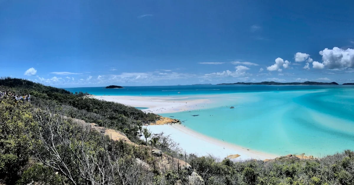
Whitehaven Beach is globally renowned for its 7 kilometres of 98% pure silica sand, which does not retain heat, allowing walkers to stroll comfortably even in the peak of the Queensland summer. However, the Whitehaven Beach Trail offers far more than a simple beach walk. The experience is defined by the dramatic contrast between the island's rugged interior and its soft coastal fringes. The trail network is primarily divided into two main areas: the northern end at Tongue Point, which overlooks the world-famous Hill Inlet, and the southern end, which provides access to the Solway Circuit and the more secluded Chance Bay.
The northern section of the trail begins at Tongue Bay, where a well-maintained track climbs through a canopy of native trees, including the distinctive Whitsunday Bottle Tree and various species of acacia. As you ascend, the vegetation thins, revealing the first glimpses of Hill Inlet—a stunning cove where the tide shifts the sand and water to create a constantly changing palette of turquoise, blue, and green. The lookout points here are the primary objective for most walkers, providing the iconic "swirl" view that has become the signature image of the Australian coastline.
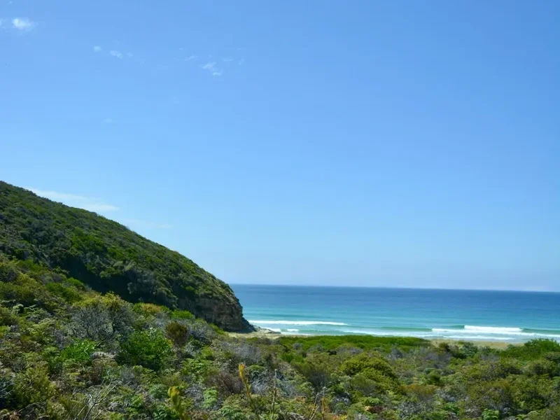
For those seeking a more immersive hiking experience, the southern trails offer a deeper dive into the island's geology. The Solway Circuit leads walkers past impressive rock formations and provides views over Solway Passage and the surrounding islands. Continuing further, the track to Chance Bay takes you away from the day-trip crowds and into a quieter, more reflective environment. Here, the forest is alive with the sounds of honeyeaters and the occasional rustle of a lace monitor in the undergrowth. The trail concludes at the secluded Chance Bay, a smaller but equally beautiful beach that offers a glimpse of what the Whitsundays felt like before they became a global tourism destination. This is a landscape defined by its purity, its geological history, and the sheer brilliance of its light.
History and Cultural Context
The Whitsunday Islands, including Whitsunday Island and the Whitehaven Beach area, are the traditional lands of the Ngaro people, often referred to as the "Sea People" of the Great Barrier Reef. For over 9,000 years, the Ngaro inhabited these islands, navigating the complex waterways in sophisticated bark canoes called 'walpals'. The Whitehaven Beach Trail passes through areas that were once vital for the Ngaro's survival, providing sources of fresh water, timber for tools, and vantage points for monitoring the movement of marine life and other groups. Evidence of their long-standing connection to the land can be found throughout the Whitsundays in the form of stone tool quarries and rock art, most notably at Nara Inlet on nearby Hook Island.
European history in the region began with Captain James Cook's passage through the Whitsunday Passage in 1770 on the HMS Endeavour. Cook named the passage after the day he believed it was—Whit Sunday—though modern calculations suggest it was actually Whit Monday. The beach itself was not named until 1879 by Staff Commander E.P. Bedwell of the HMS Llewellyn, who named it "Whitehaven" after the town in Cumberland, England. The silica sand that makes the beach so famous was once considered for industrial use; in the early 20th century, there were proposals to mine the sand for glass manufacturing, but the logistical challenges of transporting it from the island fortunately preserved the site.
In the mid-20th century, the Whitsundays began their transformation into a tourism mecca. Whitsunday Island was declared a National Park, ensuring that the unique ecosystem of Whitehaven Beach would be protected from development. Today, the management of the trail and the beach is a collaborative effort between the Queensland Parks and Wildlife Service (QPWS) and the Great Barrier Reef Marine Park Authority (GBRMPA). The cultural heritage of the Ngaro people is increasingly recognised and celebrated, with interpretive signage along the trails helping visitors understand the deep spiritual and practical connection the traditional owners have with this sea-country.
Want more background? Read extended notes on history and cultural context → Learn more
Seasonal Highlights and Weather Reality
The Whitsundays enjoy a tropical climate, which means the Whitehaven Beach Trail is accessible year-round, but the experience varies significantly between the dry and wet seasons. Understanding these patterns is crucial for planning a comfortable and safe walk.
The Dry Season (April to October): This is widely considered the best time to visit. The weather is characterised by clear blue skies, lower humidity, and mild temperatures ranging from 20°C to 26°C. The "Trade Winds" (south-easterlies) are most prevalent during this time, providing a cooling breeze that makes the uphill sections of the trail much more manageable. This is also the peak season for whale watching; from June to September, humpback whales migrate through the Whitsunday Passage, and walkers at the Hill Inlet or Solway lookouts can often spot them breaching in the distance.
The Wet Season (November to March): This period brings higher temperatures (often exceeding 30°C) and significant humidity. While the landscape becomes incredibly lush and the birdlife more active, the heat can be punishing on the exposed sections of the trail. This is also "Stinger Season" in North Queensland. While the walk itself is unaffected, any post-hike swim requires the use of a full-body lycra stinger suit to protect against Irukandji and Box Jellyfish. Tropical cyclones are a possibility during these months, which can lead to temporary closures of the island and its trails. However, the wet season also brings dramatic afternoon thunderstorms that can make the colours of the Hill Inlet appear even more vivid against a dark, moody sky.
Water Temperature: The water remains warm throughout the year, averaging 23°C in winter and 29°C in summer. Regardless of the season, the UV index in the Whitsundays is consistently high. Even on overcast days, the reflection of the sun off the white silica sand can cause severe sunburn in a very short amount of time. Walkers should always check the Bureau of Meteorology (BOM) forecast for "Whitsunday Island" before departing from the mainland.
Recommended Itinerary
Whitehaven Beach Trail Progression
Early Morning: Arrival and Tongue Bay
- Arrive at Tongue Bay via boat (usually between 8:30 AM and 9:30 AM)
- Disembark at the beach or via a tender to the small jetty
- Begin the ascent toward the Hill Inlet Lookouts
- The track is a well-formed gravel and stone path with some stairs
- Pass through dry rainforest and coastal scrub
- Keep an eye out for lace monitors (goannas) sunning themselves on the rocks
Morning: Hill Inlet Lookouts
- Reach the three distinct lookout platforms at the top of the ridge
- Distance: 1.3 km return from Tongue Bay
- Time: 45 minutes to 1 hour (including photography time)
- Lookout 1: Offers the classic wide-angle view of the swirling sands
- Lookout 2: Provides a closer perspective of the northern entrance of the inlet
- Lookout 3: Looks back toward the main stretch of Whitehaven Beach
- This is the best time for photography as the morning light illuminates the turquoise water
Midday: The Solway Circuit and South Whitehaven
- Transfer by boat to the southern end of Whitehaven Beach (or walk the 7 km beach stretch if time and tides permit)
- Begin the Solway Circuit from the southern trailhead
- Distance: 1.2 km loop
- Time: 30–40 minutes
- The trail climbs through "grass trees" (Xanthorrhoea) and cycads
- View the impressive volcanic rock formations that form the "backbone" of the island
- Enjoy views over Solway Passage toward Haslewood and Lupton Islands
Afternoon: Chance Bay Extension and Departure
- From the Solway Circuit junction, follow the track toward Chance Bay
- Distance: 3.6 km return from the main beach
- Time: 1.5 hours
- This section is more rugged and less travelled than the lookout tracks
- Walk through a variety of island ecosystems, including closed forest and open woodland
- Arrive at Chance Bay for a secluded swim (stinger suit required in season)
- Return to the main beach for your boat pickup (usually between 3:00 PM and 4:30 PM)
- Final stroll along the silica sands of Whitehaven South before departing
Important Notes:
- There are no shops or water stations on the island; you must carry everything
- Tides significantly affect the appearance of Hill Inlet; aim for a mid-tide for the best "swirl" effect
- The beach is 7 km long; walking the full length in soft sand is more tiring than it looks
- Mobile reception is patchy and generally only available at the higher lookout points
- Always check your boat's departure time; they cannot wait for late hikers
Planning and Bookings
Book Your Trip
Everything you need to plan your journey
Accommodation
Find places to stay near Airlie Beach
Flights
Search flights to Airlie Beach
Essential Preparation
The most critical aspect of planning a walk on the Whitehaven Beach Trail is arranging transport. Since there is no road access or bridge to Whitsunday Island, you must book a commercial tour, a water taxi, or have access to a private vessel. Most tours depart from Airlie Beach (Port of Airlie or Abel Point Marina) or Hamilton Island Marina. If you are staying in Airlie Beach, allow at least 60–90 minutes for the boat journey each way.
Fitness requirements for the trail are generally low to moderate. The Hill Inlet Lookout track is well-graded and accessible to most people with a basic level of mobility. However, the Chance Bay track is more of a traditional bushwalk with uneven surfaces and some elevation gain. The primary challenge is the heat and humidity; even a short walk can be exhausting if you are not properly hydrated and sun-protected. It is highly recommended to base yourself in Airlie Beach or Hamilton Island for at least 3 days to allow for weather flexibility, as boat tours may be cancelled in high winds.
Trail Accommodation
Whitehaven Beach is primarily a day-trip destination, and there are no hotels, lodges, or hostels on Whitsunday Island. However, for those who wish to experience the trail at sunrise or sunset, there is a single managed camping area.
Whitehaven Beach Camping Area:
- Managed by Queensland Parks and Wildlife Service (QPWS)
- Located at the southern end of the beach, nestled in the trees
- Capacity is limited and bookings are essential, often months in advance
- Facilities: Composting toilets are provided
- What's NOT provided: No fresh water, no showers, no power, no rubbish bins
- Cost: Approximately $7.25 per person per night (subject to change)
- Access: Via water taxi or private boat only
Alternative Accommodation:
- Airlie Beach: Offers everything from luxury resorts to backpacker hostels
- Hamilton Island: High-end hotels, apartments, and holiday homes
- Live-aboard sailing boats: Many multi-day sailing trips include a stop at Whitehaven Beach and allow time for the trails
Required Gear
- Footwear: Sturdy walking sandals or lightweight hiking shoes. While the beach is fine for bare feet, the trails have sharp rocks and roots
- Sun Protection: A wide-brimmed hat, UV-rated sunglasses, and high-SPF sunscreen (reef-safe preferred)
- Clothing: Lightweight, breathable, moisture-wicking fabrics. Long sleeves are recommended for sun protection
- Swimwear: For a post-hike dip
- Stinger Suit: Essential from November to May; many tour operators provide these
- Day Pack: A small 15–20L pack to carry water and supplies
- Navigation: The trails are well-marked, but a downloaded offline map (like AllTrails or Google Maps) is useful
What to Bring
- Water: Minimum 2–3 litres per person. There is absolutely no potable water on the island
- Food: High-energy snacks and a packed lunch. Most day tours provide lunch, but if you are on a water taxi, you must bring your own
- Rubbish Bags: You must pack out all your waste, including food scraps and fruit peels
- Personal Medications: Including antihistamines for insect bites
- Camera/Phone: With a waterproof case or dry bag for the boat transfer
- Power Bank: To ensure your phone remains charged for photos and emergency use
- Insect Repellent: To protect against sandflies (midges) which can be prevalent in the forest sections
Permits
For the vast majority of visitors, no specific hiking permit is required to walk the Whitehaven Beach Trail. The access to the National Park is generally included in the price of your commercial boat tour or water taxi. However, there are specific scenarios where permits are mandatory.
Camping Permits: If you intend to stay overnight at the Whitehaven Beach camping area, you must obtain a permit from the Queensland National Parks booking service. These permits are highly sought after and should be booked as soon as your travel dates are confirmed. You will be issued a permit tag that must be displayed on your tent.
Commercial and Group Activities: If you are organising a commercial photography shoot, a large organised group event (such as a wedding or a corporate retreat), or a guided tour, you must apply for a Special Activity Permit through the Great Barrier Reef Marine Park Authority and QPWS. This process can take several weeks and involves fees.
Private Vessels: If you are visiting on a private boat, you do not need a permit to land on the beach or use the trails, but you must adhere to the Great Barrier Reef Marine Park zoning rules. Ensure you are aware of where you can anchor (look for the blue "No Anchoring" buoys) to protect the fragile coral reefs surrounding the island. Public moorings are available in Tongue Bay but are often full by mid-morning.
Drone Permits: The use of drones is strictly regulated. Whitsunday Island is a National Park, and flying a drone for commercial purposes requires a permit. For recreational use, you must follow CASA regulations and ensure you are not flying over people or interfering with the many seaplanes and helicopters that frequent the area. Many tour operators prohibit drones entirely for the comfort of other guests.
Other Activities in the Area
The Whitehaven Beach Trail is often just one part of a broader Whitsunday adventure. Consider these activities to complement your hike:
- Snorkelling at Haslewood Island: Located just across the Solway Passage from Whitehaven, Chalkies Beach on Haslewood Island offers excellent snorkelling over fringing reefs with a high chance of seeing sea turtles.
- Scenic Flights: To truly appreciate the scale of Hill Inlet and the nearby Heart Reef, take a seaplane or helicopter tour. Most flights depart from Hamilton Island or Whitsunday Airport (Shute Harbour).
- Ocean Rafting: For those who enjoy a high-speed, adrenaline-fuelled journey, ocean rafting tours provide a "buffet" of stops including snorkelling, the Hill Inlet walk, and beach time.
- Sailing: Charter a yacht or join a multi-day sailing trip. Waking up at anchor in Tongue Bay before the day-trip boats arrive is a magical experience.
- Ngaro Sea Trail: For experienced kayakers or boaters, the Ngaro Sea Trail connects Whitsunday, Hook, and South Molle Islands, offering a multi-day journey through the cultural heart of the region.
- Whitsunday Peak: If you have another day, head to nearby Cid Harbour and hike to the top of Whitsunday Peak for a 360-degree view of the entire archipelago.
Safety and Conditions
Heat and Hydration: The most common safety issue on the Whitehaven Beach Trail is heat exhaustion. The combination of high temperatures, high humidity, and the reflective power of the silica sand can lead to rapid dehydration. Walkers should drink water frequently, even if they do not feel thirsty. If you begin to feel dizzy, nauseous, or develop a headache, find shade immediately and notify your tour guide or companions.
Marine Stingers: From October to May, the waters surrounding Whitsunday Island are home to dangerous jellyfish, including the Box Jellyfish and the tiny, nearly invisible Irukandji. While the trail is on land, most hikers want to swim afterwards. Always wear a stinger suit during these months. If someone is stung, douse the area with vinegar (most tour boats and beach stations carry this) and seek immediate medical attention. Do not rub the sting.
Wildlife Encounters: Lace monitors (goannas) are common on the trails. While generally shy, they can be defensive if cornered or if they smell food. Do not feed them, as this encourages aggressive behaviour. On the beach, be mindful of stingrays and small lemon sharks in the shallows; they are generally harmless but can give you a fright. Shuffle your feet when entering the water to alert them to your presence.
Tides and Currents: Hill Inlet is famous for its shifting sands, but these are caused by powerful tidal currents. Do not attempt to swim across the inlet; the currents are deceptively strong and can pull even strong swimmers out to sea. Stick to the designated swimming areas on the main beach.
Emergency Communication: There are no emergency phones on the island. Mobile signal is strongest at the Hill Inlet Lookouts but non-existent in the valleys or at Chance Bay. In an emergency, contact your tour operator via radio (if you have one) or head to the lookouts to try and get a signal for a 000 call. Most commercial boats are equipped with first aid kits and defibrillators.
Side Trips and Points of Interest
Betty's Beach: A tiny, secluded cove located just around the corner from the Hill Inlet Lookouts. At low tide, you can walk from the main lookout path down to this quiet spot. It is often much less crowded than the main beach and offers a beautiful perspective of the inlet's northern mouth.
The Whitsunday Bottle Tree: Along the Solway Circuit, look for the Brachychiton compactus, or Whitsunday Bottle Tree. Endemic to the region, these trees have a distinctive swollen trunk used for water storage, allowing them to survive the long dry season. They are a fascinating example of the island's botanical adaptation.
Solway Passage Viewpoint: While the Hill Inlet view gets all the fame, the view from the Solway Circuit looking south is equally impressive in a different way. It showcases the rugged, volcanic nature of the islands and the deep blue, high-energy waters of the passage where the Coral Sea meets the inner islands.
Silica Sand "Squeak": Not a side trip, but a point of interest—as you walk along the beach section of the trail, listen for the "squeak" of the sand. The high purity and uniform grain size of the silica cause it to emit a high-pitched sound underfoot, a phenomenon found in only a few places on Earth.
Leave No Trace
Whitsunday Island is a highly sensitive environment. The very things that make it beautiful—the pure sand and clear water—are easily degraded by human impact. As a visitor, you have a responsibility to ensure the island remains pristine for future generations.
Your responsibility as a walker:
- Do not take the sand: It is illegal to remove silica sand from Whitehaven Beach. Even a small amount taken by thousands of visitors would eventually deplete the beach. Security at Hamilton Island and Proserpine airports frequently confiscate sand from tourists.
- Stay on the marked tracks: The island's soil is thin and prone to erosion. Walking off-trail destroys native vegetation and can lead to "social trails" that scar the landscape.
- Pack out all rubbish: This includes "organic" waste like apple cores or banana peels. These are not native to the island and can attract pests or change the feeding habits of native wildlife.
- No drones without permits: Respect the peace of other visitors and the safety of the many low-flying aircraft in the area.
- Use the provided toilets: Composting toilets are available at Tongue Bay and the southern end of the beach. Use them to prevent contamination of the island's limited groundwater.
- Protect the reef: If you swim after your hike, do not stand on the coral. Use reef-safe sunscreen to prevent chemical damage to the marine ecosystem.