Wheeler Peak Summit Trail - New Mexico's Alpine Crown
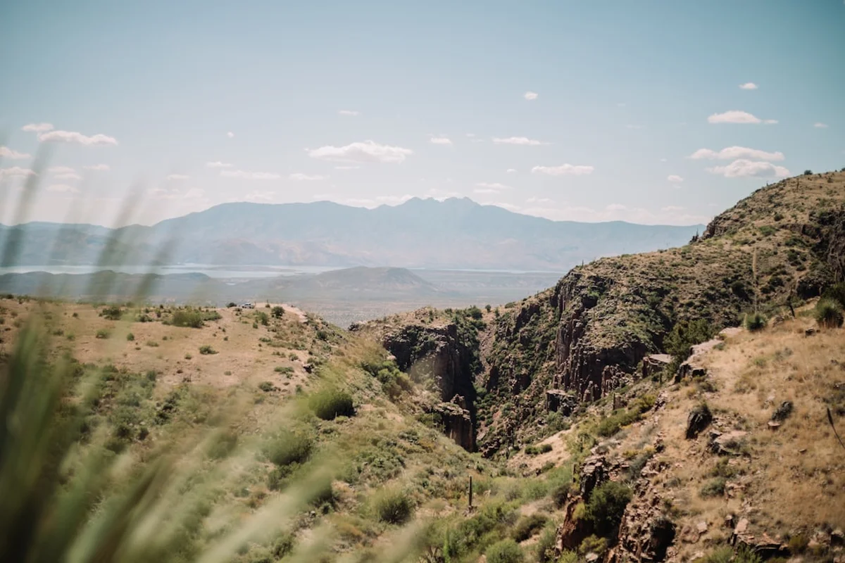
The Wheeler Peak Summit Trail is the definitive high-altitude challenge in the Southwestern United States, leading hikers to the highest point in New Mexico at an elevation of 4,011 metres. Located within the rugged Sangre de Cristo Mountains—the southernmost subrange of the Rocky Mountains—this 13.7-kilometre out-and-back journey offers a profound transition through distinct ecological zones. Starting from the base of the Taos Ski Valley, the route ascends through dense subalpine forests of Engelmann spruce and corkbark fir, eventually breaking through the treeline into a vast, wind-swept alpine tundra. The trail is characterised by its steep, relentless switchbacks and the dramatic backdrop of the Wheeler Peak Wilderness, a 7,600-hectare sanctuary of pristine mountain terrain. Reaching the summit provides a 360-degree panorama that stretches across the Rio Grande Rift to the west and the rolling plains of eastern New Mexico, offering a perspective of the American West that is both humbling and exhilarating. This is not merely a walk; it is a high-altitude pilgrimage that demands physical stamina, careful timing, and a deep respect for the volatile mountain weather of the high desert.
- Distance: 13.7 km return
- Elevation Gain: 920 m
- Duration: 6–8 hours
- Difficulty: Challenging (due to altitude and steepness)
- Highest Point: 4,011 m (Wheeler Peak Summit)
- Trailhead: Williams Lake Trailhead, Taos Ski Valley
- Best Time: June to September (to avoid deep snow and avalanche risk)
- Permits: No permit required for day hiking
Overview
The Wheeler Peak Summit Trail is a masterclass in vertical geography. While many associate New Mexico with arid deserts and red-rock mesas, the Wheeler Peak Wilderness reveals a different side of the "Land of Enchantment"—one defined by jagged granite peaks, glacial cirques, and alpine meadows that remain snow-dusted well into July. The trail begins at approximately 3,100 metres, an elevation that already poses a challenge for those arriving from sea level. The initial kilometres follow a well-maintained path through the forest, shared with those heading to the popular Williams Lake, before branching off for the serious business of the summit ascent.
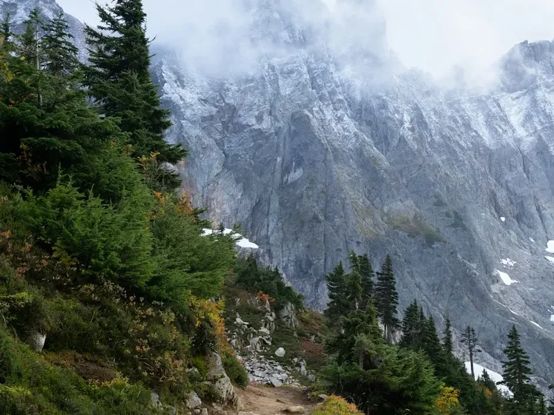
What sets Wheeler Peak apart from other regional summits is the sheer dramatic shift in environment. As you climb, the towering conifers begin to stunt and twist into krummholz formations—trees "bent by the wind"—before disappearing entirely. The final three kilometres are a test of resolve, consisting of over 30 switchbacks carved into the scree and talus slopes of the mountain's western face. Here, the air thins significantly, and every step requires a conscious effort of breath and movement. The reward for this exertion is a summit experience that feels truly detached from the world below. The peak itself is a narrow ridge, often shared with native bighorn sheep that navigate the precipitous cliffs with ease. To the north, the "false summit" of Mount Walter (3,990 m) stands as a sentinel, while to the south, the ridge continues toward Simpson Peak and Old Mike Peak.
The experience is heavily dictated by the "monsoon" weather patterns of the Southwest. During the peak summer months of July and August, the mountains generate their own weather systems. Clear blue mornings can transform into violent electrical storms by early afternoon. This reality creates a unique rhythm for the hike: a pre-dawn start is almost mandatory to ensure a safe descent before the lightning arrives. The Wheeler Peak Summit Trail is a journey of contrasts—from the cool, shaded silence of the forest to the exposed, sun-drenched intensity of the alpine ridge.
History and Cultural Context
The mountains surrounding Wheeler Peak hold deep spiritual and historical significance, particularly for the people of Taos Pueblo, who have inhabited the valley below for over a millennium. To the Tiwa-speaking people of the Pueblo, these peaks are not merely geographical features but sacred landmarks that play a central role in their traditional cosmology and seasonal ceremonies. Blue Lake, located just over the ridge from Wheeler Peak, is the most sacred site for the Taos Pueblo, representing the place of their origin. While the summit trail itself is on public Forest Service land, hikers are often reminded of the proximity to these sacred areas, which were famously returned to the Pueblo's control in 1970 after a decades-long legal battle, marking a landmark victory for Indigenous land rights in the United States.
The peak is named after Major George Montague Wheeler, an American explorer and cartographer who led the "Wheeler Survey" in the late 19th century. His mission was to map the Western United States south of the 40th parallel, a monumental task that combined military reconnaissance with scientific enquiry. Wheeler’s teams were among the first to formally document the elevation and topography of the Sangre de Cristo range, though the local Indigenous and Hispano populations had known these peaks intimately for centuries. Before it was officially named Wheeler Peak, the mountain was often referred to simply as "The Peak" or by various Spanish names by the settlers in the Taos Valley who used the high meadows for summer sheep grazing.
In the early 20th century, the area became a focus for the burgeoning conservation movement. The Wheeler Peak Wilderness was established as part of the original Wilderness Act of 1964, ensuring that the landscape would remain "untrammelled by man." This protection has allowed the ecosystem to recover from early mining and logging efforts in the Taos Ski Valley area. Today, the trail serves as a bridge between the modern recreational industry of the ski resort and the timeless, protected wilderness of the high peaks.
Want more background? Read extended notes on history and cultural context → Learn more
Seasonal Highlights and Weather Reality
The window for a safe and enjoyable hike on Wheeler Peak is relatively narrow, dictated by the heavy snowfall of the Southern Rockies and the volatile summer atmosphere. Understanding these seasonal shifts is critical for any hiker planning an ascent.
Summer (Late June to Early September): This is the primary hiking season. By late June, the snow has usually receded enough from the switchbacks to allow passage without specialised alpine gear. July and August are the warmest months, but they also coincide with the North American Monsoon. Almost every afternoon, moisture-laden air from the Gulf of California and the Gulf of Mexico rises over the mountains, creating towering cumulonimbus clouds. Lightning is a frequent and lethal hazard on the exposed ridges of Wheeler Peak. Hikers must adhere to the "Noon Rule"—be off the summit and heading back into the treeline by midday.
Autumn (September to October): Many locals consider September the "golden window" for Wheeler Peak. The monsoon rains subside, leading to stable, clear blue skies and crisp temperatures. The aspen trees in the lower valleys turn a brilliant gold, creating a spectacular visual contrast against the dark evergreens. However, the first high-altitude snowfalls can occur as early as mid-September, and temperatures at the summit can drop well below freezing even on sunny days.
Winter and Spring (November to May): During these months, Wheeler Peak is a serious mountaineering undertaking. The trail is buried under several metres of snow, and the steep western face becomes a high-risk avalanche zone. Only those with expert-level winter navigation skills, avalanche safety training, and equipment such as crampons and ice axes should attempt the summit. Spring is particularly treacherous, as the "rotten" melting snow can lead to dangerous post-holing and unpredictable slides.
Recommended Itinerary

Wheeler Peak Day Hike Progression
Early Morning: The Forest Ascent (06:00 – 08:00)
- Start: Williams Lake Trailhead (3,110 m)
- Distance: 0 km to 3.5 km
- The first section follows the Williams Lake Trail, a wide and relatively gentle path through old-growth forest.
- Listen for the sound of the Rio Hondo as it flows nearby.
- At approximately 3.2 km, you will reach a clearly marked junction. The left fork continues to Williams Lake, while the right fork begins the Wheeler Peak Summit Trail.
- This is the final opportunity for significant shade before the exposed climb begins.
Mid-Morning: The Switchbacks (08:00 – 10:30)
- Distance: 3.5 km to 6 km
- Elevation: 3,300 m to 3,850 m
- The trail narrows and the gradient increases sharply. You will encounter a series of over 30 switchbacks.
- The forest thins, transitioning into krummholz (stunted trees) and then open alpine tundra.
- Views of Williams Lake appearing as a turquoise jewel far below to the south.
- Keep a steady pace; the thinning air at 3,500+ metres will begin to affect your breathing and heart rate.
Midday: The Ridge and Summit (10:30 – 12:00)
- Distance: 6 km to 6.8 km (Summit)
- Elevation: 3,850 m to 4,011 m
- The trail reaches the main ridge line. To the north, you will see Mount Walter, which many hikers mistake for the true summit.
- Follow the ridge south. The path is rocky and exposed but well-defined.
- Summit: Wheeler Peak (4,011 m). A small stone windbreak provides some shelter.
- Spend 15–20 minutes enjoying the views of the Latir Wilderness to the north and the Moreno Valley to the east.
- Monitor the sky closely for any developing "cauliflower" clouds (cumulus congestus).
Afternoon: The Descent (12:00 – 15:00)
- Distance: 6.8 km to 13.7 km
- Retrace your steps down the switchbacks. The descent is taxing on the knees; trekking poles are highly recommended.
- Once back at the Williams Lake junction, you may choose to take the short 15-minute detour to the lake for a celebratory foot soak in the cold glacial water.
- Return to the trailhead at Taos Ski Valley.
- Celebrate with a meal in the village, reflecting on the 920 metres of vertical gain achieved.
Important Notes:
- Total moving time is typically 5–7 hours, but allow 8 hours for breaks and acclimatisation.
- There is no reliable water source after the Williams Lake junction; carry all you need.
- The summit is often 10–15 degrees Celsius cooler than the trailhead.
- Cell phone service is intermittent and should not be relied upon for navigation.
Planning and Bookings
Book Your Trip
Everything you need to plan your journey
Accommodation
Find places to stay near Taos
Flights
Search flights to Taos
Essential Preparation
The most critical aspect of preparing for Wheeler Peak is acclimatisation. The trailhead starts at an elevation higher than many mountain summits in other parts of the world. If you are travelling from sea level, it is strongly advised to spend at least two nights in Taos (2,100 m) or Taos Ski Valley (2,800 m) before attempting the hike. Rapid ascent to 4,000 metres without acclimatisation significantly increases the risk of Acute Mountain Sickness (AMS).
Logistically, the hike is straightforward as it does not require permits or advanced bookings for the trail itself. However, parking at the Williams Lake Trailhead can be extremely limited, especially on summer weekends. Arriving before 07:00 is essential to secure a spot. The base town of Taos provides all necessary amenities, including outdoor gear shops, supermarkets, and medical facilities. Ensure your vehicle is in good working order for the climb up NM-150, which is paved but steep and winding.
Trail Accommodation
This is a day hike requiring no overnight accommodation on the trail itself. Camping is permitted within the Wheeler Peak Wilderness, but strict regulations apply to protect the fragile ecosystem.
Camping Options:
- Wilderness Camping: You may camp in the wilderness area, but you must be at least 100 metres away from Williams Lake and any other water sources. No campfires are allowed in the high-alpine zones; use a portable stove only.
- Developed Campgrounds: Several Carson National Forest campgrounds are located along NM-150 (the road to the ski valley), including Lower Hondo, Hopewell Lake, and Twining Campgrounds. These usually offer basic facilities like pit toilets and fire rings.
- Taos Ski Valley: A variety of lodges, hotels, and alpine-style chalets are available at the base of the mountain. These range from luxury resorts to more modest lodge rooms. Booking in advance is recommended during the peak summer season.
What's NOT Provided:
- There are no huts, shelters, or toilets on the Wheeler Peak Summit Trail.
- There are no trash bins; you must pack out all waste.
- Potable water is only available at the base in Taos Ski Valley.
Required Gear
- Footwear: Sturdy hiking boots with good traction and ankle support. The scree on the upper switchbacks is loose and can easily cause ankle rolls.
- Clothing Layers: A moisture-wicking base layer, an insulating mid-layer (fleece or down), and a high-quality waterproof/windproof shell. Even in August, the summit wind chill can be brutal.
- Trekking Poles: Highly recommended for the 920-metre descent to protect your knees and provide stability on loose rock.
- Navigation: A physical topographic map and compass, or a GPS device with offline maps downloaded. The trail is well-marked, but cloud cover can reduce visibility to a few metres.
- Sun Protection: High-SPF sunscreen, lip balm with SPF, polarised sunglasses, and a wide-brimmed hat. At 4,000 metres, the UV radiation is significantly more intense than at sea level.
- Emergency Kit: A basic first aid kit, a space blanket, a whistle, and a multi-tool.
What to Bring
- Water: At least 3 litres per person. The dry mountain air and physical exertion lead to rapid dehydration, which exacerbates altitude sickness.
- Water Treatment: If you plan to refill at Williams Lake (the only source), you must use a filter or chemical treatment to protect against Giardia.
- Food: High-calorie, nutrient-dense snacks (nuts, dried fruit, energy bars) and a substantial lunch. Your body burns significantly more energy at high altitudes.
- Electrolytes: Powdered electrolyte mixes can help maintain hydration levels and prevent cramping.
- Headlamp: Essential for the recommended early morning start, even if you plan to be back by afternoon.
- Personal Items: Tissues, hand sanitiser, and a small bag for packing out waste (including toilet paper).
Permits
Currently, no permits are required for day hikers or overnight backpackers within the Wheeler Peak Wilderness. This makes it one of the most accessible high-altitude peaks in the United States. However, this lack of a permit system places a greater responsibility on the hiker to follow wilderness ethics and regulations to ensure the area remains open and pristine.
Key Regulations:
- Group Size: Maximum group size is limited to 15 people to minimise impact on the trail and alpine tundra.
- Dogs: Dogs are permitted but must be kept on a leash at all times. This is strictly enforced to protect the native bighorn sheep and marmot populations.
- Parking: While the trail is free, parking at the Taos Ski Valley "Hikers Parking" lot is mandatory. Do not park in areas reserved for resort guests or emergency vehicles, as towing is common.
- Commercial Use: Any organised commercial groups or guiding services must obtain a Special Use Permit from the Carson National Forest office in Taos.
Future Changes: The Forest Service occasionally reviews visitor impact. It is always wise to check the Carson National Forest official website or visit the Forest Service office in Taos before your trip to ensure no temporary restrictions or new permit requirements have been implemented.
Other Activities in the Area
The region surrounding Taos is a cultural and outdoor hub, offering numerous ways to recover after your summit bid:
- Taos Pueblo: A UNESCO World Heritage site, this living Native American community has been inhabited for over 1,000 years. Visitors can take guided tours to learn about the history, architecture, and culture of the Tiwa people.
- Rio Grande Gorge Bridge: Located about 15 kilometres west of Taos, this is one of the highest bridges in the US. The views into the 240-metre deep volcanic chasm are breathtaking.
- Taos Ski Valley Via Ferrata: For those seeking more vertical thrills, the resort offers a guided via ferrata climbing experience on the cliffs above the village.
- Hot Springs: Several natural hot springs, such as Black Rock or Manby, are located along the Rio Grande. They are the perfect way to soothe sore muscles after a 13-kilometre hike.
- Art Galleries: Taos has been a world-renowned art colony since the early 20th century. Spend an afternoon exploring the galleries and museums in the historic town plaza.
- Mountain Biking: The North Boundary Trail is a legendary mountain bike route that offers high-alpine riding for those with the energy to spare.
Safety and Conditions
The Lightning Threat: This is the single greatest danger on Wheeler Peak. The summit and the long ridge leading to it are completely exposed. If you see clouds building vertically, hear thunder, or feel your hair standing on end, descend immediately. Do not wait for the rain to start. Lightning can strike several kilometres away from the actual storm cell.
Altitude Sickness (AMS): Symptoms include headache, nausea, dizziness, and fatigue. The only cure for AMS is descent. If symptoms persist or worsen, do not continue upward. High Altitude Pulmonary Oedema (HAPO) and Cerebral Oedema (HACO) are rare but life-threatening conditions that require immediate evacuation to lower elevation.
Hydration and Nutrition: The air in New Mexico is exceptionally dry. You will lose significant moisture through respiration alone. Drink frequently, even if you do not feel thirsty. Ensure you are consuming enough salt and carbohydrates to fuel the intense climb.
Wildlife Encounters: You are likely to see marmots, pikas, and bighorn sheep. While they may seem habituated to humans, they are wild animals. Do not feed them, as this disrupts their natural diet and can lead to aggressive behaviour. Black bears are present in the lower forested sections; keep a clean camp if staying overnight and make noise while hiking through dense brush.
Navigation in Whiteout: If a cloud descends on the summit, the trail can become difficult to follow among the rocks. Stay calm, use your GPS or compass to maintain your bearing, and look for the wooden posts or rock cairns that mark the route. If you lose the trail, it is generally safer to stay put until visibility improves than to wander onto the steep cliffs of the eastern face.
Side Trips and Points of Interest
Williams Lake: Most hikers pass the junction for Williams Lake on their way to the summit. This glacial tarn sits in a spectacular cirque at 3,365 metres. The water is crystal clear and surrounded by rock slides where pikas are frequently heard whistling. It adds only about 1.5 kilometres to your total distance and is a perfect spot for a post-summit lunch.
Mount Walter: Located just 0.5 kilometres north of Wheeler Peak along the ridge, Mount Walter is the second-highest point in New Mexico (3,990 m). It is often called a "false summit" because hikers reaching the ridge from the switchbacks see it first. It is worth the five-minute detour for the slightly different perspective it offers of the northern wilderness.
Horseshoe Lake: For those with exceptional fitness, a much longer loop can be made by descending the East Fork Trail toward Horseshoe Lake. This is a high-alpine lake that sits in a remote basin. This route is significantly longer (over 20 km) and requires careful navigation, but it offers a solitude that the main summit trail lacks.
The "Kachina Peak" View: From the summit of Wheeler, look across the valley to the west to see Kachina Peak, the highest point of the Taos Ski Valley resort. In winter, this is world-class expert ski terrain; in summer, its rocky face provides a dramatic counterpoint to the Wheeler massif.
Leave No Trace
The Wheeler Peak Wilderness is a fragile environment. The alpine tundra above the treeline consists of plants that may only grow a few millimetres per year. A single footstep off the trail can destroy decades of growth. Adhering to Leave No Trace principles is essential for the continued health of this ecosystem.
Specific Guidelines for Wheeler Peak:
- Stay on the Trail: Especially on the switchbacks. "Cutting" switchbacks causes massive erosion, destroys vegetation, and eventually ruins the trail for everyone.
- Pack It In, Pack It Out: This includes organic waste like orange peels and apple cores, which do not decompose quickly in the cold, dry alpine environment and are harmful to wildlife.
- Respect the Tundra: When you reach the summit, sit on durable surfaces like rocks rather than on the fragile alpine grasses and flowers.
- Waste Management: There are no toilets. If you must go, use a "WAG bag" (waste alleviation and gelling) to pack out human waste, or dig a "cathole" at least 15–20 cm deep in the forested areas, well away from water. Above the treeline, packing it out is the only responsible option.
- Leave What You Find: Do not collect wildflowers, rocks, or historical artefacts. Leave the cairns (rock piles) as they are; do not build new ones, as this can confuse other hikers.