
West Highland Way - Scotland's Premier Long-Distance Journey
The West Highland Way is the definitive Scottish trekking experience—a 154 km odyssey that traverses the dramatic transition from the pastoral Lowlands to the rugged, mist-shrouded peaks of the Highlands. Established in 1980 as Scotland's first official long-distance route, it begins in the suburban town of Milngavie, just north of Glasgow, and concludes at the foot of Ben Nevis in Fort William. The trail is a masterclass in geographical diversity, leading walkers along the "bonnie banks" of Loch Lomond, across the vast and desolate expanse of Rannoch Moor, through the hauntingly beautiful Glen Coe, and over the high mountain passes that guard the approach to the outdoor capital of the UK. This is not merely a walk; it is a pilgrimage through the heart of Scottish history, folklore, and wilderness.
- Distance: 154.0 km one-way
- Duration: 5–9 days (7 days is the most common itinerary)
- Season: April to October (May and September offer the best balance of weather and fewer insects)
- Accommodation: A mix of hotels, B&Bs, campsites, and wild camping (subject to local bylaws)
- Highest point: Devil's Staircase (550 m)
- Total Elevation Gain: Approximately 4,760 m
- Direction: South to north (Milngavie to Fort William is the traditional and most rewarding route)
Overview
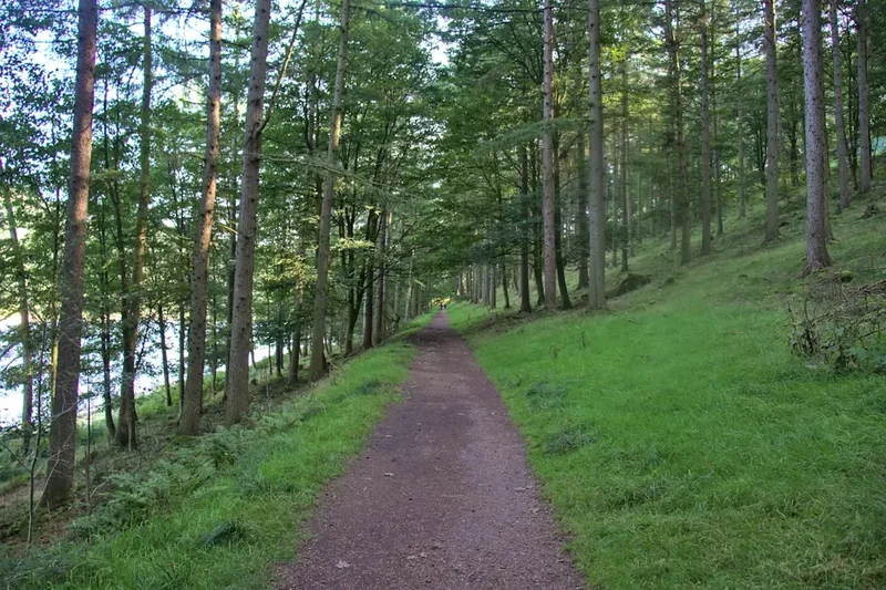
The West Highland Way is a journey of increasing intensity. It begins with gentle, rolling terrain through the Mugdock Country Park and the farmlands of Stirlingshire, allowing walkers to find their rhythm before the landscape begins to buckle and rise. The first major milestone is Conic Hill, which marks the Highland Boundary Fault—the literal geological line where the Lowlands end and the Highlands begin. From this vantage point, the scale of Loch Lomond reveals itself, dotted with islands that trace the fault line across the water.
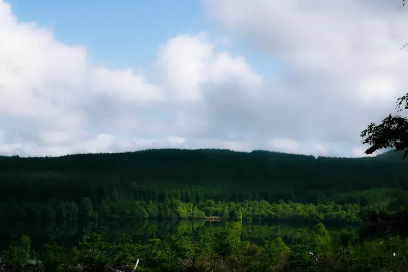
The middle section of the trail is defined by the shores of Loch Lomond. While the southern banks offer easy walking, the northern section—often referred to as the "Loch Lomond Slog"—is a technical and demanding stretch of twisted roots, rocky scrambles, and narrow paths that test the endurance of even seasoned hikers. Beyond the loch, the trail enters the glens, following the path of the River Falloch toward Tyndrum. Here, the mountains begin to crowd the horizon, their slopes scarred by ancient glacial activity and draped in purple heather.
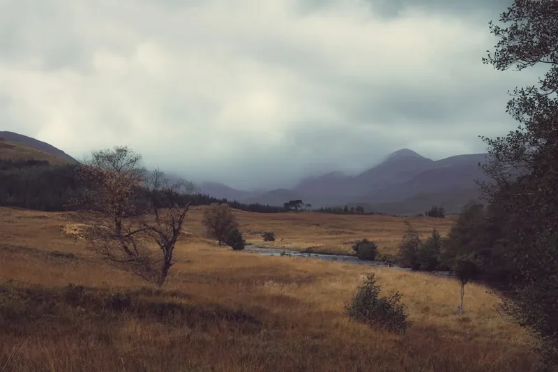
The final third of the West Highland Way is arguably the most spectacular. The crossing of Rannoch Moor is an exercise in isolation; it is one of the last remaining true wilderness areas in Europe, a vast peat bog surrounded by distant, jagged peaks. This leads directly into the jaws of Glen Coe, perhaps Scotland's most famous glen, where the trail climbs the "Devil's Staircase" to reach its highest point. The descent into Kinlochleven and the final march through the Lairigmor (the Great Pass) provides a fittingly grand finale, with the massive bulk of Ben Nevis—the highest mountain in the British Isles—looming over the finish line in Fort William. The West Highland Way is a test of stamina, a feast for the eyes, and a profound immersion into the soul of the Scottish landscape.
History and Cultural Context
The path you walk today is a tapestry woven from centuries of Scottish history. Long before it was a recreational trail, the West Highland Way was a network of disparate routes used for survival, warfare, and commerce. Large sections of the trail follow ancient "drovers' roads"—the paths used by highlanders to herd cattle from the northern pastures to the markets in the south. These routes were the lifeblood of the Highland economy for centuries, and the ruins of old shielings (summer dwellings) and inns along the way serve as silent reminders of this vanished way of life.
In the 18th century, following the Jacobite Risings, the British government commissioned the construction of military roads to allow for the rapid movement of troops through the rebellious Highlands. Engineers like General George Wade and Major William Caulfeild designed these roads with characteristic straightness and robust stone bridges. Today, walkers on the West Highland Way still tread upon these historic surfaces, particularly through Glen Coe and the Lairigmor. The trail also passes through areas of deep clan significance, including the lands of the Colquhouns, the Macfarlanes, and the Campbells. The massacre of Glen Coe in 1692, a pivotal and tragic event in Scottish history, occurred just a few kilometres from the trail's path, and the weight of this history is palpable as you walk through the shadows of the Three Sisters peaks.
The modern trail was the brainchild of Tom Hunter, a Glasgow geographer and mountaineer who first proposed a long-distance route in the 1960s. It took nearly twenty years of negotiation with landowners and local authorities before the West Highland Way was officially opened on 6 October 1980. Since then, it has become a global icon, attracting over 30,000 walkers annually who complete the full distance, and many more who enjoy shorter sections. It remains a symbol of the Scottish "Right to Roam" and the enduring appeal of the Highland wilderness.
Want more background? Read extended notes on history and cultural context → Learn more
Seasonal Highlights and Weather Reality
The Scottish Highlands are famous for having "four seasons in one day," and the West Highland Way is no exception. Weather is the primary factor in determining the difficulty of the walk. While the trail is technically open year-round, the vast majority of walkers visit between April and October.
Spring (April to May): Many experienced walkers consider May the "golden month." The weather is often at its driest, the temperatures are cool but pleasant for walking, and the hills are vibrant with new growth. Crucially, May is usually before the emergence of the Highland midge—a tiny biting insect that can make summer walking a challenge. April can still see snow on the higher passes, and the air remains crisp.
Summer (June to August): This is the peak season. The days are incredibly long, with twilight lasting until 11:00 PM in June, providing ample time for long distances. However, this is also the height of midge season. These insects swarm in still, damp conditions, particularly in the mornings and evenings. Summer also brings the most crowds, meaning accommodation must be booked many months in advance. While temperatures can reach 25°C, rain is frequent, and the humidity can make the climbs feel more strenuous.
Autumn (September to October): September is another fantastic window. The midges begin to die off with the first frosts, and the landscape transforms into a sea of gold, rust, and deep orange as the bracken and heather change colour. October brings more volatile weather, with increased rainfall and shorter daylight hours, but the solitude is much greater.
Winter (November to March): This is only for the highly experienced and well-equipped. The West Highland Way becomes a serious mountaineering undertaking. Rannoch Moor and the Devil's Staircase can be buried in deep snow, and daylight is limited to about seven hours. Many hotels and campsites along the route close during this period, and public transport is reduced. Navigation skills with map and compass are essential as the trail markers can be obscured by snow.
Recommended Itinerary
7-Day West Highland Way Itinerary
Day 1: Milngavie to Drymen
- Distance: 19 km
- Elevation gain: 210 m
- Time: 5–6 hours
- Start at the granite obelisk in Milngavie town centre
- Walk through Mugdock Country Park and past Craigallian Loch
- Pass the Glengoyne Distillery (optional tour available)
- Gentle terrain through rolling farmland and woodland
- Arrive in the village of Drymen, a popular first-night stop with several pubs
- This day serves as an excellent warm-up with minimal steep climbing
Day 2: Drymen to Rowardennan
- Distance: 24 km
- Elevation gain: 430 m
- Time: 6–7 hours
- Climb Conic Hill for the first major views of Loch Lomond and the Highland Boundary Fault
- Descend into Balmaha for a lakeside lunch
- Follow the undulating eastern shore of Loch Lomond through ancient oak woodlands
- Pass through Milarrochy Bay and Cashel
- Arrive at Rowardennan, situated at the base of Ben Lomond
- The climb over Conic Hill is the highlight, offering a dramatic transition into the Highlands
Day 3: Rowardennan to Inverarnan
- Distance: 22.5 km
- Elevation gain: 480 m
- Time: 7–8 hours
- The most technical section of the trail, often called the "Loch Lomond Slog"
- Narrow, rocky paths with many short, steep ups and downs
- Pass Rob Roy’s Cave (a traditional hiding spot of the famous outlaw)
- The path levels out after Inversnaid Hotel, passing through RSPB Inversnaid Nature Reserve
- Final stretch leads away from the loch to the famous Drovers Inn at Inverarnan
- Expect tired legs; the terrain is much slower than the distance suggests
Day 4: Inverarnan to Tyndrum
- Distance: 19.5 km
- Elevation gain: 490 m
- Time: 5–6 hours
- Follow the River Falloch upstream, passing the impressive Falls of Falloch
- Walk through Glen Falloch with views of the surrounding "Munros" (mountains over 914 m)
- Pass the halfway point of the trail near Crianlarich
- Walk through the site of the Battle of Dalrigh (1306)
- Arrive in Tyndrum, a small village with excellent facilities and a gold mining history
- The scenery becomes noticeably more mountainous and open
Day 5: Tyndrum to Kingshouse
- Distance: 30.5 km
- Elevation gain: 550 m
- Time: 8–10 hours
- The longest and most remote day of the trek
- Follow the old military road around the base of Beinn Odhar and Beinn Dorain
- Pass through Bridge of Orchy and climb to the Mam Carraigh viewpoint
- Cross the vast, desolate expanse of Rannoch Moor on a historic cobbled road
- Arrive at the Kingshouse Hotel, one of Scotland's oldest inns, with views of Buchaille Etive Mor
- This day requires good weather and steady pacing due to the lack of shelter on the moor
Day 6: Kingshouse to Kinlochleven
- Distance: 14.5 km
- Elevation gain: 430 m
- Time: 4–5 hours
- Walk toward the "Gateway to Glen Coe"
- Climb the Devil’s Staircase, a series of zig-zags leading to the trail's highest point (550 m)
- Enjoy views back toward the Glencoe mountains and north toward the Mamores
- Long, steady descent on a wide track into the village of Kinlochleven
- A shorter day that allows for recovery before the final push
Day 7: Kinlochleven to Fort William
- Distance: 24 km
- Elevation gain: 470 m
- Time: 7–8 hours
- Steep initial climb out of Kinlochleven to reach the Lairigmor (the Great Pass)
- Follow a high, desolate valley between the Mamores and the Lochaber mountains
- Pass the ruins of old crofting settlements
- Descend through forestry plantations with the first views of Ben Nevis
- Final road walk into Fort William to the "End of the Way" statue in Gordon Square
- Celebrate the completion of the 154 km journey in the local pubs
Important Notes:
- Accommodation must be booked well in advance, especially for May, June, and September
- Baggage transfer services are highly recommended to allow walking with a day pack
- The "Loch Lomond Slog" on Day 3 is significantly harder than it looks on a map
- Rannoch Moor (Day 5) is extremely exposed; there is no escape route or shelter for 15 km
- Always carry a physical map and compass, even if using GPS
- The trail is well-marked with the thistle logo, but visibility can drop to metres in mist
Planning and Bookings
Book Your Trip
Everything you need to plan your journey
Accommodation
Find places to stay near Glasgow
Flights
Search flights to Glasgow
Essential Preparation
The West Highland Way is a "moderate" trail, but its length makes it a significant physical challenge. Preparation should begin at least six months in advance. Fitness is paramount; you should be comfortable walking 20–25 km per day for several consecutive days, ideally with some elevation gain. Training should include walking in the boots you intend to wear and carrying the weight you expect to have in your pack.
Logistically, Glasgow is the primary gateway. Most walkers fly into Glasgow International Airport (GLA) and take a 20-minute train or bus to Milngavie. It is highly recommended to spend the night before your start in either Glasgow or Milngavie. Booking coordination is the biggest hurdle; because the trail passes through small villages with limited bed space, you must synchronise your daily distances with available accommodation. Many walkers use baggage transfer services (such as Travel-Lite or AMS), which transport your main luggage between stops for a fee (approx. £45–£60 for the full trip), allowing you to walk with only a light day pack.
Trail Accommodation
The West Highland Way offers a diverse range of accommodation, but demand far outstrips supply during the peak season.
Types of Accommodation:
- Hotels and B&Bs: Available in every major stop (Drymen, Balmaha, Rowardennan, Inversnaid, Inverarnan, Tyndrum, Bridge of Orchy, Kingshouse, Kinlochleven, Fort William). Expect to pay £80–£150 per night for a double room.
- Bunkhouses and Hostels: A more budget-friendly option (£25–£40 per bed). Popular spots include the Rowardennan Youth Hostel and the By The Way Hostel in Tyndrum.
- Campsites: Most villages have organised campsites with showers, toilets, and sometimes drying rooms (£10–£20 per night). Some offer "Glamping Pods" which provide a wooden shelter but require you to bring your own sleeping bag.
- Bothies: There are very few bothies (basic stone shelters) directly on the route. Rowchoish and Doune are located on the shores of Loch Lomond, but they are basic, have no facilities, and can be crowded.
- Wild Camping: Legal in most of Scotland under the Scottish Outdoor Access Code, EXCEPT within the Loch Lomond & The Trossachs National Park during the camping management season (March to September), where you must stay in a campsite or purchase a specific camping permit for designated zones.
Required Gear
- Walking Boots: Waterproof (Gore-Tex or leather) with good ankle support. Ensure they are thoroughly broken in.
- Waterproof Jacket and Trousers: Essential. Scottish rain can be horizontal and persistent. Look for high breathability ratings.
- Layered Clothing: Moisture-wicking base layers (merino wool is ideal), a fleece or insulated mid-layer, and lightweight trekking trousers (no denim).
- Socks: High-quality wool-blend hiking socks. Bring at least three pairs to ensure you always have a dry set.
- Backpack: 25–35L if using baggage transfer; 50–65L if carrying all gear. Must have a waterproof cover.
- Navigation: Physical OS Maps (Landranger 94, 95 or the dedicated WHW map) and a compass. Do not rely solely on a phone.
- Midge Net: A fine-mesh head net is essential from June to August. Standard mosquito nets are too coarse for midges.
What to Bring
- Midge Repellent: "Smidge" is the most popular local brand. DEET-based products are also effective but can damage synthetic gear.
- Blister Kit: Compeed, zinc oxide tape, and antiseptic wipes. Blisters are the #1 reason people fail to finish.
- Water Treatment: While tap water is safe, if you plan to pull from streams, use a filter (like a Sawyer Squeeze) or purification tablets.
- Food and Snacks: High-energy snacks (nuts, chocolate, dried fruit). While you can buy lunch and dinner in most villages, there are long stretches (like Rannoch Moor) with zero services.
- Sun Protection: Sunscreen and sunglasses. The Highland sun can be surprisingly strong, especially with the wind chill masking the heat.
- Power Bank: To keep your phone/GPS charged, as cold weather drains batteries quickly.
- Emergency Whistle and Foil Blanket: Standard safety items for mountain environments.
Permits
For the vast majority of the West Highland Way, no permits are required to walk the trail. Scotland’s Land Reform Act (2003) provides a statutory right of responsible access to most land and water. However, there is one critical exception regarding camping.
Loch Lomond Camping Management Zones:
Due to the high volume of visitors, Loch Lomond & The Trossachs National Park operates a camping permit system from 1 March to 30 September each year. During this time, you cannot wild camp along much of the lochside (from Drymen to past Inversnaid) without a permit. Permits cost £4 per tent, per night and must be booked in advance through the National Park website. These permits apply to specific "Camping Management Zones." If you do not have a permit, you must stay in an official commercial campsite.
Booking Strategy for Accommodation:
- The "6-Month Rule": If you are planning to stay in B&Bs or hotels, you should aim to have your bookings finalised by January for a May or June start.
- Fort William Finish: Book your final night in Fort William as soon as your start date is confirmed, as it is a major tourist hub and fills up rapidly.
- Baggage Transfer: Book this at least two weeks before you start. You will need to provide your full itinerary so they know which hotels to drop your bags at.
Transport Costs:
- Train from Glasgow to Milngavie: Approx. £5.00
- Train from Fort William back to Glasgow: Approx. £35.00–£45.00 (The West Highland Line is one of the most scenic rail journeys in the world).
- Citylink Bus (Fort William to Glasgow): Approx. £25.00–£30.00.
Other Activities in the Area
Many walkers choose to add a few days to their trip to experience the highlights of the Highlands:
- Summit Ben Nevis: The most popular "add-on." After finishing the Way, take a day to climb the UK's highest peak (1,345 m) via the Mountain Track. Allow 7–9 hours for the return trip.
- The Jacobite Steam Train: Known to many as the "Harry Potter train," this steam service runs from Fort William to Mallaig, crossing the famous Glenfinnan Viaduct.
- Glencoe Visitor Centre: Located near the trail, this centre offers excellent exhibits on the geology and the tragic history of the 1692 massacre.
- Glengoyne Distillery: Located right on the trail near Drymen, it offers tours and tastings for those who want to sample a "wee dram" of Highland single malt.
- Sea Kayaking on Loch Linnhe: Based in Fort William, this provides a different perspective of the mountains from the water.
- Steall Falls: A short drive or bus ride from Fort William into Glen Nevis leads to a spectacular wire-bridge crossing and Scotland's second-highest waterfall.
Safety and Conditions
Pre-Departure Checks:
- Check the Met Office Mountain Forecast for "West Highlands" and "Southern Highlands."
- Review the Scottish Avalanche Information Service (SAIS) if travelling in early spring (April).
- Ensure you have the "What3Words" app or a GPS device for emergency location sharing.
- Inform someone of your daily itinerary and expected arrival times.
Terrain Hazards: The West Highland Way is not a technical climb, but it is physically demanding. The "Loch Lomond Slog" (Day 3) features slippery roots and wet rocks that cause many twisted ankles. Rannoch Moor (Day 5) is the most dangerous section in bad weather; it is a vast, high-altitude plateau with no natural shelter. If the wind is high or visibility is low, the risk of exhaustion and hypothermia is genuine. The Devil's Staircase is a well-maintained path, but it is steep and exposed to the elements.
Hypothermia: Even in summer, temperatures in the Highlands can drop to near freezing at night or during heavy rain. Hypothermia is a risk if you become wet and are exposed to wind. Always carry a dry set of thermal layers in a waterproof dry-bag inside your pack.
Water Safety: Do not attempt to cross swollen streams after heavy rain. While most major crossings have bridges, some smaller burns can become impassable torrents within hours of a Highland downpour. Wait for the water to subside or find a safe alternative route.
Ticks and Lyme Disease: Ticks are prevalent in the bracken and long grass of the Highlands. Check your body every evening. Carry a tick removal tool and know how to use it. If you develop a "bullseye" rash or flu-like symptoms after the walk, consult a doctor immediately.
Side Trips and Points of Interest
Conic Hill: While technically part of the main route for many, some choose the lower forest bypass. Don't. The climb to the summit of Conic Hill (361 m) provides the single best geographical lesson on the trail, showing the sharp line where the Lowlands meet the Highlands across the islands of Loch Lomond.
Ben Lomond: For those with extra energy on Day 2 or 3, Ben Lomond (974 m) is Scotland's most southerly Munro. The path starts from Rowardennan. It adds about 4–5 hours to your day but offers unparalleled views of the entire loch and the peaks of the Trossachs.
The Drovers Inn: Located at Inverarnan, this is more than just a pub; it is a living museum. Established in 1705, it is famously "haunted" and filled with taxidermy and ancient furniture. It is the quintessential West Highland Way experience.
The Lost Valley (Coire Gabhail): A short detour from the trail near Kingshouse leads into a hidden hanging valley in Glen Coe where the MacDonald clan used to hide rustled cattle. It is a dramatic, enclosed space surrounded by vertical rock walls.
The Old Military Road: Pay attention to the construction of the path between Bridge of Orchy and Inveroran. This is one of the best-preserved sections of Caulfeild’s military road, featuring original stone culverts and a robust cobble base that has survived for over 250 years.
Leave No Trace
The West Highland Way passes through some of Scotland's most sensitive environments, including National Parks and Sites of Special Scientific Interest (SSSI). Walkers are expected to follow the Scottish Outdoor Access Code, which is based on three main principles: respect the interests of others, care for the environment, and take responsibility for your own actions.
Specific Guidelines for the Way:
- Litter: There are no bins on the trail. You must carry all rubbish, including fruit peels and tea bags, to the next village.
- Human Waste: Use public toilets in villages whenever possible. If you must go on the trail, do so at least 30 metres from water sources and bury waste in a shallow hole. Carry out all toilet paper and sanitary products.
- Wild Camping: If wild camping (where legal), keep groups small, stay only one night, and leave no trace of your campfire. Use a stove rather than an open fire to prevent scorching the ground and risking wildfires.
- Livestock: The trail passes through many working farms. Keep dogs on a short lead, especially during lambing season (March–May). Always close gates behind you.
- Path Erosion: Stay on the designated path. Braiding (walking beside the path to avoid mud) widens the trail and destroys fragile vegetation, particularly on Rannoch Moor.