West Coast Trail - Canada's Ultimate Coastal Wilderness Challenge
The West Coast Trail (WCT) is widely regarded as one of the most iconic and challenging multi-day treks in North America. Stretching 75 kilometres along the southwestern edge of Vancouver Island in British Columbia, Canada, this trail is a pilgrimage for backpackers seeking to test their physical limits against the raw power of the Pacific Ocean. Originally constructed as a lifesaving route for shipwrecked mariners—earning this stretch of coastline the ominous moniker "The Graveyard of the Pacific"—the trail now serves as a premier backcountry experience within the Pacific Rim National Park Reserve. It traverses the traditional territories of the Huu-ay-aht, Ditidaht, and Pacheedaht First Nations, whose ancestors have lived in harmony with this rugged landscape for millennia. Walking the West Coast Trail is not merely a hike; it is an immersion into a world of towering old-growth rainforests, intricate tidal ecosystems, and relentless mud, all set against the backdrop of the crashing surf.
- Distance: 75 km one-way
- Duration: 6–8 days
- Season: 1 May to 30 September (mandatory reservations required)
- Elevation Gain: Approximately 2,400 m (cumulative)
- Difficulty: Challenging/Expert (requires high fitness and backcountry experience)
- Trailheads: Pachena Bay (North), Nitinaht Village (Mid-point), and Gordon River (South)
- Direction: Can be hiked in either direction (North-to-South or South-to-North)
Overview
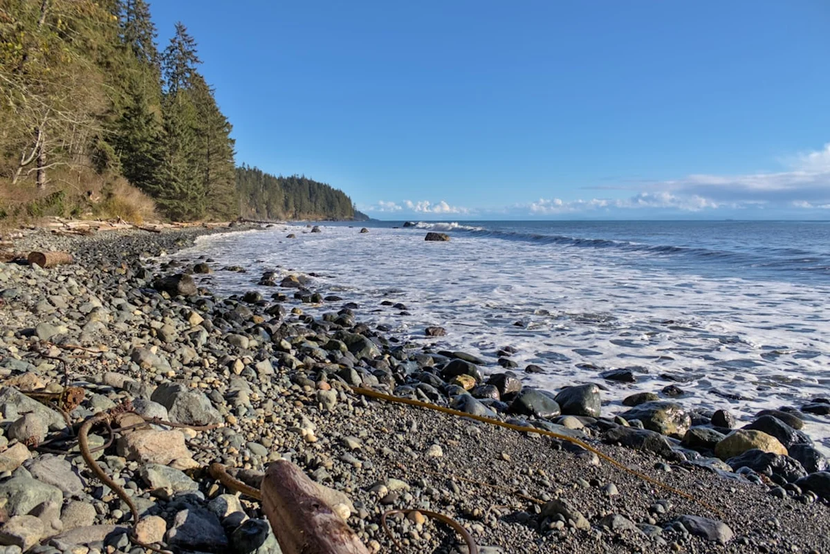
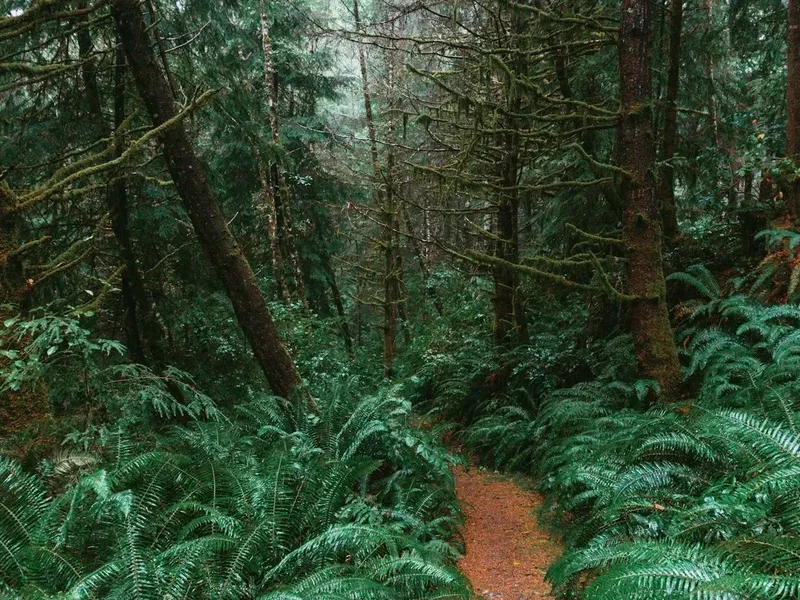
The West Coast Trail is a masterclass in environmental diversity and physical endurance. Unlike many alpine treks that focus on vertical gain to a single summit, the WCT is a horizontal battle against the elements. The terrain is notoriously difficult, consisting of deep mud that can reach mid-calf, over 70 wooden ladders (some reaching heights of 30 metres), slippery boardwalks, cable car river crossings, and unpredictable beach sections. The trail is divided into two distinct personalities: the northern section (Pachena Bay to Tsusiat Falls) is generally considered "easier" with flatter forest paths and long beach stretches, while the southern section (Tsusiat Falls to Gordon River) is a brutal test of stamina, featuring steep ravines, technical root systems, and the infamous "Green Gold" (slippery algae-covered rocks).
Weather is the defining factor of any WCT expedition. Located in a temperate rainforest, the trail receives significant precipitation even during the peak summer months. Fog is a constant companion, often rolling in off the Pacific to shroud the ancient Sitka spruce and Western red cedar trees in a ghostly mist. When the rain falls, the trail transforms; dry creek beds become rushing torrents, and the forest floor turns into a quagmire of temperate muck. However, when the sun breaks through, the beauty is unparalleled. Hikers are treated to views of whales breaching offshore, sea lions basking on rocky outcrops, and sunsets that paint the entire Pacific horizon in hues of violet and gold.
Logistics on the trail are managed with precision by Parks Canada to ensure both hiker safety and environmental preservation. Only a limited number of hikers are permitted to start the trail each day, ensuring that the wilderness character remains intact. This regulation fosters a unique sense of community among those on the trail; you will often find yourself sharing a campfire at night with the same group of people you passed on a ladder earlier that afternoon. It is a journey that demands respect for the tides, a high tolerance for discomfort, and a deep appreciation for the raw, uncurated beauty of the Canadian West Coast.
History and Cultural Context
The history of the West Coast Trail is inextricably linked to the maritime tragedies of the 19th and early 20th centuries. Between 1854 and 1906, dozens of ships were lost along this treacherous coastline due to hidden reefs, violent storms, and powerful currents. The most famous of these disasters was the wreck of the SS Valencia in 1906, where 136 people perished. The public outcry following this tragedy forced the Canadian government to take action. They established the "Dominion Lifesaving Trail," which included the construction of a telegraph line and a rugged path to allow shipwreck survivors and rescuers to reach safety. Lighthouses at Pachena Point and Carmanah Point were also established during this era to guide mariners through the "Graveyard of the Pacific."
However, the human history of this land goes back much further. The trail passes through the ancestral lands of the Nuu-chah-nulth people, specifically the Huu-ay-aht, Ditidaht, and Pacheedaht First Nations. For thousands of years, these Nations utilised the coastal resources, established permanent villages, and maintained sophisticated social and economic systems. Hikers today pass through areas of immense cultural significance, including former village sites and places of spiritual importance. Parks Canada works in close partnership with these First Nations to co-manage the trail, and hikers are often greeted by First Nations trail guardians who provide invaluable local knowledge and maintain the infrastructure. Respecting these lands as living cultural landscapes is a fundamental requirement for every visitor.
In 1970, the West Coast Trail was formally incorporated into the Pacific Rim National Park Reserve. Since then, it has evolved from a survival route into one of the world's most sought-after hiking experiences. The remnants of its maritime past—rusted anchors, ship boilers, and the lighthouses themselves—remain as silent sentinels along the route, reminding hikers of the trail's somber origins.
Want more background? Read extended notes on history and cultural context → Learn more
Seasonal Highlights and Weather Reality
The West Coast Trail is only open from 1 May to 30 September. Outside of this window, the trail is closed to the public due to extreme weather conditions, including hurricane-force winds, torrential rains, and the removal of essential infrastructure like cable cars and bridges. Even within the operating season, weather is highly variable.
May and June: These months are often the wettest of the hiking season. Mud levels are at their highest, and temperatures can remain cool, especially at night (8–12°C). However, the trail is less crowded, and the lushness of the rainforest is at its peak. This is also an excellent time for birdwatching as migratory species return to the coast.
July and August: This is the "high season." These months offer the best chance for extended periods of sunshine and drier trail conditions. Daytime temperatures typically hover between 15°C and 22°C. However, this is also the time when fog is most prevalent, often lasting well into the afternoon. Reservations for these months sell out almost instantly.
September: A favourite for many experienced hikers. The weather often remains stable, and the "bugs" (mosquitoes and biting flies) begin to diminish. The nights become noticeably cooler, and the light takes on a golden, autumnal quality. By late September, the risk of early autumn storms increases, which can lead to trail closures or difficult evacuations.
Regardless of the month, hikers must be prepared for rain. It is not uncommon to experience four seasons in a single day. Hypothermia is a genuine risk even in mid-summer if a hiker becomes wet and is unable to find shelter or change into dry clothing. The "West Coast Fog" can also reduce visibility on beach sections, making it essential to have a compass or GPS and a firm understanding of the tide tables.
Recommended Itinerary
7-Day North-to-South Itinerary (Pachena Bay to Gordon River)
Day 1: Pachena Bay to Michigan Creek
- Distance: 12 km
- Time: 4–6 hours
- Terrain: Mostly flat forest trail with some boardwalks
- Key Waypoints: Pachena Lighthouse, sea lion haul-out
- Highlights: The first glimpse of the Pachena Lighthouse and the sound of sea lions barking in the distance. This is a gentle introduction to the trail, allowing you to find your "trail legs" and adjust your pack weight.
- Camp: Michigan Creek (beach camping with a freshwater source).
Day 2: Michigan Creek to Tsusiat Falls
- Distance: 13 km
- Time: 5–7 hours
- Terrain: Beach walking and forest sections; first encounter with ladders
- Key Waypoints: Tsocowis Creek, Klanawa River (cable car)
- Highlights: Reaching Tsusiat Falls, a spectacular waterfall that drops directly onto the beach. It is a popular spot for a bracing freshwater swim.
- Camp: Tsusiat Falls (iconic beach camping).
Day 3: Tsusiat Falls to Cribs Creek
- Distance: 17 km
- Time: 6–8 hours
- Terrain: Extensive beach walking; requires careful tide monitoring
- Key Waypoints: Nitinaht Narrows (ferry crossing), Hole-in-the-Wall
- Highlights: Crossing the Nitinaht Narrows via the First Nations-operated ferry. You can often purchase fresh crab or salmon from the local operators here—a legendary WCT luxury.
- Camp: Cribs Creek (protected by a natural reef, great for tide pooling).
Day 4: Cribs Creek to Carmanah Beach
- Distance: 10 km
- Time: 4–5 hours
- Terrain: Beach and rocky headlands
- Key Waypoints: Carmanah Lighthouse, Bonilla Point
- Highlights: Visiting the Carmanah Lighthouse and exploring the sea caves near Bonilla Point. This is a shorter day, allowing for recovery before the technical sections ahead.
- Camp: Carmanah Beach or Bonilla Point.
Day 5: Carmanah Beach to Walbran Creek
- Distance: 9 km
- Time: 5–7 hours
- Terrain: Increasing technicality; heavy mud and root systems
- Key Waypoints: Logan Creek (suspension bridge and massive ladders)
- Highlights: The Logan Creek suspension bridge offers dizzying views of the ravine below. The ladders here are some of the longest on the trail.
- Camp: Walbran Creek (beautiful estuary camping).
Day 6: Walbran Creek to Camper Bay
- Distance: 9 km
- Time: 6–8 hours
- Terrain: Very technical; deep mud, slippery boardwalks, and inland forest
- Key Waypoints: Cullite Creek (cable car), Sandstone Creek
- Highlights: Navigating the "Green Gold" sections and the deep mud of the inland forest. This is often cited as the most physically demanding day due to the constant up-and-down movement.
- Camp: Camper Bay (enclosed by steep cliffs).
Day 7: Camper Bay to Gordon River (Trailhead)
- Distance: 5 km
- Time: 4–6 hours
- Terrain: Extremely technical; steep ravines and massive root systems
- Key Waypoints: Thrasher Cove junction, Gordon River ferry
- Highlights: The final push to the Gordon River. The terrain is relentless until the very end. A final ferry crossing takes you to Port Renfrew and the completion of your journey.
- Note: Many hikers add an extra day to stay at Thrasher Cove to explore the Owen Point sea caves (tide dependent).
Planning and Bookings
Book Your Trip
Everything you need to plan your journey
Accommodation
Find places to stay near Victoria
Flights
Search flights to Victoria
Essential Preparation
Preparation for the West Coast Trail should begin at least six months in advance. Physical fitness is paramount; you should be capable of carrying a 15–20 kg pack for 6–8 hours a day over uneven, slippery terrain. Training should include hill repeats and hiking on uneven surfaces to strengthen ankles and knees. Logistics involve coordinating transport to and from the trailheads. Most hikers base themselves in Victoria or Nanaimo. The West Coast Trail Express bus provides seasonal shuttle services between Victoria, Nanaimo, Bamfield (Pachena Bay), and Port Renfrew (Gordon River). Booking this transport in advance is as critical as the trail permit itself.
Every hiker must attend a mandatory orientation session at either the Pachena Bay or Gordon River Information Centre before starting. These sessions cover current trail conditions, tide safety, and wildlife protocols. Failure to attend will result in your permit being voided.
Trail Accommodation
There are no huts or permanent shelters for hikers on the West Coast Trail. This is a pure wilderness camping experience. Hikers must stay at designated campsites, which are generally located at the mouths of creeks or on beaches.
Campsite Facilities:
- Bear-proof food lockers (mandatory usage)
- Pit toilets (composting or pit style)
- Freshwater sources (creeks or rivers; all water MUST be treated)
- No designated tent pads; camping is typically on the sand or forest floor
What is NOT Provided:
- No shelters or huts (you must bring a high-quality, waterproof tent)
- No cooking facilities or fuel
- No rubbish bins (Pack it in, Pack it out)
- No cell service or WiFi
Costs and Availability:
- The West Coast Trail Overnight Use Fee is approximately $160 CAD (subject to annual change).
- A reservation fee of $25.75 CAD applies.
- Ferry crossing fees (Nitinaht Narrows and Gordon River) are approximately $70 CAD total and are usually paid at the time of booking or at the Information Centres.
Required Gear
- Footwear: High-quality, waterproof hiking boots with excellent ankle support. They must be broken in well before the trip. Gaiters are essential for keeping mud and sand out of your boots.
- Backpack: 60–75L capacity with a waterproof liner or high-quality rain cover.
- Tent: A lightweight, 3-season tent with a full rainfly. It must be able to withstand high winds and heavy rain.
- Sleeping System: A synthetic sleeping bag (rated to 0°C) is preferred over down, as synthetic retains warmth when damp. A closed-cell or inflatable sleeping pad is necessary for insulation from the cold ground.
- Navigation: The official Parks Canada WCT Map (provided at orientation) and a waterproof tide table (essential). A compass or GPS is recommended for foggy beach sections.
- Safety: A bear canister (if not using lockers) and bear spray. A whistle and a small signal mirror.
What to Bring
- Food: Lightweight, high-calorie meals for 7–8 days. Dehydrated meals are standard. Include plenty of snacks (nuts, chocolate, energy bars) for "on-the-go" fuel.
- Water Treatment: A reliable filter (pump or gravity) or chemical purification (tabs/drops). The water in coastal creeks is often tea-coloured due to tannins but is safe once treated.
- Cooking: A lightweight canister stove (Jetboil, MSR Pocket Rocket) and sufficient fuel. Bring a backup lighter and waterproof matches.
- Clothing: The layering system is key. Merino wool or synthetic base layers (no cotton!), a fleece or down mid-layer, and a professional-grade waterproof shell (Gore-Tex). Bring at least 3–4 pairs of high-quality wool hiking socks.
- Personal Care: Biodegradable soap, trowel (for emergencies), toilet paper, sunblock, and insect repellent. A small quick-dry towel.
- First Aid: Extensive blister kit (moleskin, Leukotape), anti-inflammatories, antiseptic wipes, and any personal medications.
Permits
Permits for the West Coast Trail are among the most competitive in the world. Parks Canada uses an online reservation system that typically opens in early January for the upcoming season. For 2025, the reservation launch date is expected to be in late January. Demand is so high that the entire season can sell out within minutes of the system opening.
Booking Strategy:
- Create your Parks Canada account and log in at least 30 minutes before the reservation window opens.
- Be flexible with your start dates and your direction of travel (North-to-South is slightly more popular).
- Have your group size, preferred start date, and credit card information ready.
- If you miss out, check the website frequently for cancellations, which happen often as the season approaches.
Standby List: In previous years, a standby list was available at the Information Centres for hikers without reservations. However, this has become increasingly unreliable and is not recommended for those travelling from overseas or with tight schedules. Always aim for a confirmed reservation.
Permit Costs (Approximate):
- Overnight Use Fee: $160.00
- Reservation Fee: $25.75
- Ferry Fees: $70.00
- Total: Approximately $255.75 CAD per person.
Other Activities in the Area
If you have extra time before or after your hike, the surrounding region offers world-class adventures:
- Whale Watching in Bamfield: The waters around the northern trailhead are prime territory for grey whales, humpbacks, and orcas. Local charters offer intimate tours.
- Surfing in Port Renfrew: While not as famous as Tofino, Port Renfrew has several rugged surf breaks for experienced cold-water surfers.
- Avatar Grove: Located near Port Renfrew, this area contains some of the most spectacular old-growth trees in Canada, including "Canada's Gnarliest Tree."
- Sport Fishing: Both Bamfield and Port Renfrew are world-renowned for salmon and halibut fishing.
- Tofino and Ucluelet: A 3-hour drive from the northern trailhead, these towns are the heart of BC's surf culture and offer luxury spas, fine dining, and the stunning Long Beach.
Safety and Conditions
Tide Awareness: This is the single most important safety factor on the WCT. Many beach sections are impassable at high tide. Hikers have been trapped against cliffs by rising waters, leading to dangerous situations and expensive rescues. You MUST consult your tide table and map before every beach section. If in doubt, take the inland forest route.
Wildlife: The trail is home to black bears, cougars, and wolves. While attacks are extremely rare, hikers must practice "Bear Aware" protocols. Store all food, toiletries, and trash in the provided bear lockers. Never cook near your tent. Carry bear spray in an accessible location (not inside your pack) and know how to use it.
Ladders and Boardwalks: The wooden infrastructure on the WCT is often wet, mossy, and incredibly slippery. Maintain three points of contact on ladders at all times. Do not rush. Many of the trail's injuries occur from simple slips on "flat" boardwalks.
Surge Channels: These are deep clefts in the rocky shoreline where the ocean surges in with great force. Never attempt to jump across a surge channel. Use the designated inland bypasses. Even on calm days, "sneaker waves" can sweep hikers off rocky shelves.
Evacuation: Evacuations from the WCT are difficult and expensive. They are typically conducted by Parks Canada via boat or helicopter. Most evacuations are for lower-leg injuries (broken ankles, torn ligaments) caused by slips in the mud or on roots. Ensure you have comprehensive travel insurance that covers backcountry rescue.
Side Trips and Points of Interest
Tsusiat Falls: While on the main route, this is a point of interest that deserves extra time. The falls are roughly 10 metres high and provide a natural shower. At low tide, you can walk behind the veil of water.
Hole-in-the-Wall: A natural rock archway located on the beach between Tsusiat and Cribs Creek. It is a fantastic photography spot but can only be reached at lower tides. Check your tables carefully before committing to the beach route here.
Owen Point Sea Caves: Located near Thrasher Cove at the southern end of the trail. These massive caverns are carved into the sandstone cliffs. They are only accessible at tides lower than 1.8 metres. If the tide is right, this is arguably the most beautiful geological feature on the entire trail.
Carmanah Lighthouse: While you cannot enter the lighthouse itself, the grounds offer a fascinating look at the life of a modern lightkeeper. The views from the cliffs here across the Juan de Fuca Strait are immense.
Leave No Trace
The West Coast Trail is a fragile ecosystem. With thousands of hikers visiting each year, the potential for environmental degradation is high. Adhering to Leave No Trace principles is a condition of your permit.
- Pack it in, Pack it out: This includes all food scraps (even biodegradable ones like orange peels), feminine hygiene products, and micro-trash.
- Respect Wildlife: Observe from a distance. Never feed any animal, including birds or squirrels. Feeding wildlife habituates them to humans, which often leads to the animal being destroyed.
- Minimize Campfire Impact: Use only driftwood for fires. Keep fires small and below the high-tide line so the ocean can wash away the ashes. Never cut standing trees or branches.
- Proper Waste Disposal: Use the provided pit toilets. If you are caught between sites, dig a "cathole" at least 20 cm deep and 60 metres away from any water source. Pack out your toilet paper.
- Stay on the Trail: Even when it is muddy, stay on the main path. Walking around mud puddles widens the trail and destroys delicate forest vegetation.