Warrumbungle Grand High Tops Circuit
The Warrumbungle Grand High Tops Circuit is a challenging multi-day trek through the heart of New South Wales' only volcanic mountain range, the Warrumbungle National Park. This circuit offers a unique opportunity to explore a landscape sculpted by ancient eruptions, featuring dramatic rock formations, diverse flora and fauna, and panoramic views across the surrounding plains. It's a journey into a rugged, arid environment that contrasts sharply with the lush coastal regions of Australia, showcasing a different facet of the continent's natural beauty. The circuit is designed for experienced hikers seeking a remote and rewarding wilderness experience, demanding self-sufficiency and a good level of fitness.
- Distance: 35.3 km
- Elevation Gain: 1450 m
- Duration: 2-3 days
- Difficulty: Challenging
- Season: Autumn and Spring (March-May & September-November)
- Closest City: Coonabarabran
- Trailhead Access: Pincham Carpark
- National Park Entry Fees Apply
Overview
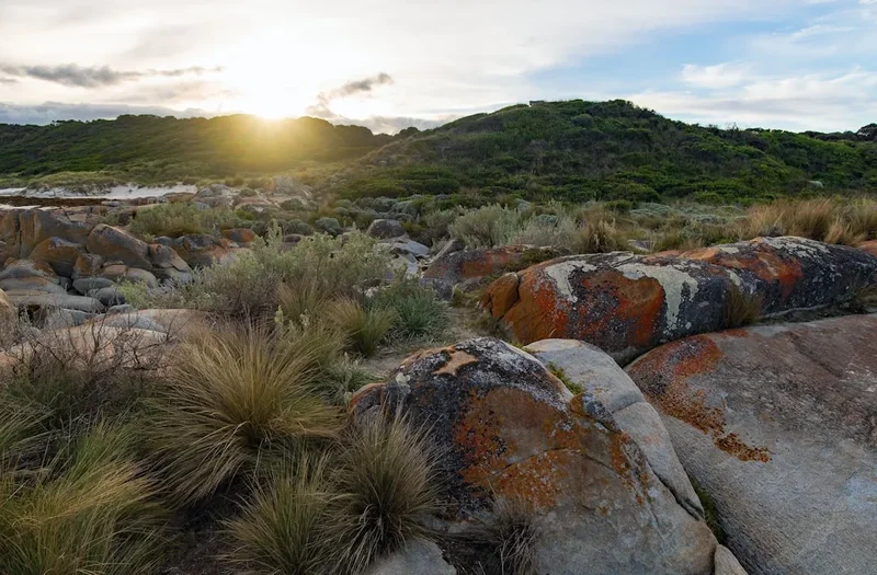
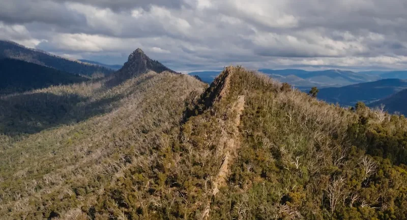
The Grand High Tops Circuit is a loop that takes you through the most spectacular and geologically significant parts of the Warrumbungle National Park. Unlike many Australian bushwalks, this circuit involves substantial elevation changes and requires navigating rocky, sometimes steep terrain. The trail winds through a landscape dominated by ancient volcanic plugs, dykes, and lava flows, creating a dramatic and otherworldly scenery. Key features include the iconic Breadknife, a striking dolerite dyke, and the Grand High Tops themselves, offering breathtaking vistas from their summits.
The park is renowned for its clear night skies, making it an internationally recognised Dark Sky Park. Hikers often find themselves camping under a canopy of stars that is simply unparalleled. The flora is adapted to the arid conditions, with hardy eucalypts, wattles, and native grasses clinging to the rocky slopes. Wildlife sightings are common, including kangaroos, wallabies, various bird species, and if you're lucky, the elusive brush-tailed rock-wallaby. The circuit is best tackled in the cooler months of autumn and spring to avoid the extreme heat of summer and the potential for frost in winter.
This walk is not for the faint-hearted. It requires careful planning, adequate supplies, and a solid understanding of navigation. The remoteness of the park means that self-reliance is paramount. However, for those who are prepared, the Grand High Tops Circuit offers an unforgettable adventure into a truly unique Australian wilderness.
History and Cultural Context
The Warrumbungle Mountains have a rich cultural history stretching back tens of thousands of years. For millennia, the land was the traditional country of the Gamilaroi (Gomeroi) people, who have deep spiritual and practical connections to the mountains, rivers, and the life they sustain. The volcanic formations were significant landmarks, and the area provided vital resources for sustenance and shelter. Evidence of their occupation can be found in rock shelters and artefact sites, though these are protected and should not be disturbed.
European settlement in the region began in the mid-19th century, with pastoralists moving into the fertile plains surrounding the Warrumbungles. The unique geological features of the mountains soon attracted attention, and by the early 20th century, efforts were underway to protect this remarkable landscape. The Warrumbungle National Park was officially gazetted in 1953, preserving its natural and cultural heritage for future generations.
The development of walking tracks, including the Grand High Tops Circuit, has allowed visitors to experience the park's dramatic scenery. Early explorers and surveyors mapped out routes that form the basis of today's trails. The park's volcanic origins, with its distinctive dolerite dykes and trachyte plugs, have made it a site of geological interest, studied by scientists for decades. The ongoing management of the park by NSW National Parks and Wildlife Service aims to balance visitor access with the conservation of its unique ecosystems and cultural significance.
Seasonal Highlights and Weather Reality
The Warrumbungle Grand High Tops Circuit is best experienced during the shoulder seasons of autumn (March to May) and spring (September to November). During these periods, daytime temperatures are generally pleasant, ranging from 15°C to 25°C, making hiking more comfortable and reducing the risk of heatstroke.
Autumn (March-May): This is often considered the prime season. The heat of summer subsides, the vegetation begins to take on autumnal hues, and the air is crisp and clear. Nights can be cool, dropping to around 5°C to 10°C, so warm sleeping gear is essential. Rainfall is generally low, but occasional showers can occur.
Spring (September-November): Spring brings a burst of life to the park. Wildflowers begin to bloom, and the landscape becomes more vibrant. Temperatures are similar to autumn, with mild days and cool nights. Sandflies can become more prevalent as the weather warms up, so insect repellent is advisable.
Summer (December-February): Summer in the Warrumbungles can be extremely hot, with daytime temperatures frequently exceeding 35°C and sometimes reaching over 40°C. The exposed nature of the Grand High Tops Circuit means there is little shade, and the risk of heat exhaustion and dehydration is very high. Hiking during the peak summer months is strongly discouraged and can be dangerous. If attempting a summer walk, start extremely early, carry significantly more water than you think you'll need, and be prepared to turn back if conditions become unsafe.
Winter (June-August): Winter can be cold, with daytime temperatures averaging between 10°C and 15°C. Nights can drop below freezing, with frost common and occasional light snowfalls on the higher peaks. While the cold can be bracing, the clear, crisp air offers excellent visibility for the expansive views. The trails are generally less crowded during winter, but hikers must be prepared for cold conditions and potentially icy patches on shaded sections of the track.
Recommended Itinerary
2-Day Warrumbungle Grand High Tops Circuit Itinerary
Day 1: Pincham Carpark to Balor Hut (via The Breadknife)
- Distance: 17.6 km
- Elevation Gain: 850 m
- Time: 6–8 hours
- Start at Pincham Carpark
- Follow the Grand High Tops Track
- Pass through diverse vegetation, including dry sclerophyll forest and heathland
- Reach the iconic Breadknife, a spectacular dolerite dyke
- Continue towards the Grand High Tops, with significant ascents and descents
- Arrive at Balor Hut, a designated camping area with basic facilities
- Set up camp and enjoy the remote wilderness
- Evening: Opportunity for stargazing in the Dark Sky Park
Day 2: Balor Hut to Pincham Carpark (via Grand High Tops)
- Distance: 17.7 km
- Elevation Gain: 600 m
- Time: 6–8 hours
- Depart Balor Hut after breakfast
- Ascend to the Grand High Tops, exploring the summit areas
- Enjoy panoramic views of the park and surrounding plains
- Descend via the Grand High Tops Track, retracing some of your steps but with different perspectives
- Pass through various lookouts and points of interest
- Return to Pincham Carpark
3-Day Warrumbungle Grand High Tops Circuit Itinerary (More Relaxed Pace)
Day 1: Pincham Carpark to Spire Lookout
- Distance: 10 km
- Elevation Gain: 500 m
- Time: 3–4 hours
- Start at Pincham Carpark
- Follow the Grand High Tops Track
- Reach Spire Lookout, a scenic spot with good views
- Set up camp at the designated Spire Lookout camping area
- Explore the immediate surroundings
Day 2: Spire Lookout to Balor Hut (via The Breadknife)
- Distance: 7.6 km
- Elevation Gain: 350 m
- Time: 3–4 hours
- Depart Spire Lookout
- Continue on the Grand High Tops Track
- Pass The Breadknife
- Arrive at Balor Hut
- Set up camp and enjoy the remote wilderness
- Evening: Stargazing
Day 3: Balor Hut to Pincham Carpark (via Grand High Tops)
- Distance: 17.7 km
- Elevation Gain: 600 m
- Time: 6–8 hours
- Depart Balor Hut after breakfast
- Ascend to the Grand High Tops, exploring the summit areas
- Enjoy panoramic views
- Descend via the Grand High Tops Track
- Return to Pincham Carpark
Important Notes:
- This circuit requires camping at designated sites (Balor Hut and Spire Lookout). Bookings for camping are essential.
- Water sources are extremely limited; carry all the water you need for the entire trip.
- The track is well-marked but can be steep and rocky in places.
- Weather can change rapidly; be prepared for sun, wind, and potential rain.
- National Park entry fees apply.
Planning and Bookings
Book Your Trip
Everything you need to plan your journey
Accommodation
Find places to stay near Coonabarabran
Flights
Search flights to Coonabarabran
Essential Preparation
The Warrumbungle Grand High Tops Circuit is a challenging trek that demands thorough preparation. Given the remote nature of the park and the limited facilities, self-sufficiency is key. Before embarking on this hike, ensure you have a solid understanding of the route, potential hazards, and your own physical capabilities. It is highly recommended to inform someone of your itinerary and expected return time.
The closest town to Warrumbungle National Park is Coonabarabran, approximately 30 minutes' drive from the park entrance. Coonabarabran offers essential services including supermarkets for stocking up on supplies, outdoor gear shops, accommodation options (motels, caravan parks), and fuel stations. It's advisable to complete all your shopping and refuelling in Coonabarabran before entering the park, as services within the park are non-existent.
Access to the trailhead at Pincham Carpark is via a sealed road from the park entrance. The road is generally in good condition, but it's always wise to check for any alerts or closures with NSW National Parks and Wildlife Service before your trip. Parking is available at Pincham Carpark, but it can become busy during peak periods, especially on weekends and public holidays.
Trail Accommodation
The Grand High Tops Circuit involves overnight camping at designated sites within Warrumbungle National Park. There are no huts or lodges along the route. Campers must be self-sufficient and carry all necessary camping equipment.
Designated Camping Areas:
- Balor Hut: Located approximately halfway along the circuit, this is a popular camping spot. It offers basic facilities including pit toilets and a shelter. There is no water available at Balor Hut, so all water must be carried in.
- Spire Lookout: An alternative camping spot for those opting for a 3-day itinerary. It also provides pit toilets and a shelter, with no water supply.
Booking Requirements:
- Camping within Warrumbungle National Park requires advance booking and payment through the NSW National Parks and Wildlife Service website or by phone.
- Bookings are essential, especially during school holidays, weekends, and public holidays, as sites can fill up quickly.
- There are no fees for national park entry itself, but camping fees apply per person, per night.
Facilities Provided:
- Pit toilets
- Shelter/hut at camping areas
- Designated camping platforms or areas
What's NOT Provided:
- Water (carry all you need)
- Showers
- Cooking facilities (bring your own stove and fuel)
- Electricity or charging points
- Rubbish bins (pack it in, pack it out)
Seasonal Availability: Camping is available year-round, but conditions vary significantly. Summer can be extremely hot, while winter can be cold with frost. Autumn and spring offer the most pleasant camping conditions.
Required Gear
- Backpack: A sturdy, comfortable backpack of 50-70 litres capacity is recommended to carry all your gear and supplies. Ensure it has a good hip belt for weight distribution.
- Tent: A lightweight, durable tent suitable for the expected weather conditions. Ensure it is well-ventilated for warmer months and can withstand wind.
- Sleeping Bag: A 3-season sleeping bag rated for temperatures down to 0°C is advisable, as nights can be cool, especially in autumn and spring.
- Sleeping Mat: For insulation and comfort.
- Hiking Boots: Sturdy, waterproof hiking boots with good ankle support are essential. Ensure they are well broken-in to prevent blisters.
- Navigation: A detailed topographic map of Warrumbungle National Park, a compass, and a GPS device or reliable navigation app on your phone (with offline maps downloaded). Mobile phone reception is unreliable within the park.
- Head Torch: With spare batteries. Essential for navigating in the dark, setting up camp, and for the Dark Sky Park experience.
- First-Aid Kit: Comprehensive kit including bandages, antiseptic wipes, pain relievers, blister treatment, personal medications, and any other essentials.
- Sun Protection: Wide-brimmed hat, sunglasses, and high SPF sunscreen. The sun can be intense, especially at higher elevations.
- Insect Repellent: Especially important during warmer months to ward off flies and mosquitoes.
- Water Bottles/Bladder: Capacity for at least 3-4 litres per person per day, as water is scarce.
- Water Filter/Purification Tablets: As a backup, though reliable water sources are rare.
- Trekking Poles: Highly recommended for stability on steep and uneven terrain, and to reduce strain on knees during descents.
What to Bring
- Food: Lightweight, non-perishable food for all meals and snacks for the duration of your trip. Consider freeze-dried meals, energy bars, nuts, dried fruit, and jerky. Plan your meals carefully to ensure you have enough calories.
- Cooking Equipment: A lightweight camping stove, fuel, cooking pot, utensils, plate, bowl, and mug.
- Toiletries: Biodegradable soap, toothbrush, toothpaste, toilet paper (carry out used paper), hand sanitiser, and any personal hygiene items.
- Clothing:
- Moisture-wicking base layers (synthetic or merino wool)
- Insulating mid-layer (fleece or down jacket)
- Waterproof and windproof outer jacket
- Hiking trousers (quick-drying)
- Spare socks (wool or synthetic)
- Warm hat and gloves (even in warmer months, evenings can be cool)
- Camp shoes or sandals (optional, for comfort at camp)
- Rubbish Bags: To pack out all your waste.
- Duct Tape and Repair Kit: For minor gear repairs.
- Camera: To capture the stunning scenery and night skies.
- Book or Journal: For downtime at camp.
- Emergency Whistle: For signalling in an emergency.
Permits
To undertake the Warrumbungle Grand High Tops Circuit, you will need to secure camping permits for the designated overnight sites. These permits are managed by NSW National Parks and Wildlife Service (NPWS) and are essential for overnight stays at Balor Hut and Spire Lookout.
Booking Process:
- Online Booking: The most convenient way to book is through the official NSW National Parks and Wildlife Service website. Navigate to the Warrumbungle National Park section and look for the camping booking system.
- Phone Booking: Alternatively, you can book by calling the NPWS contact centre.
- Advance Booking: It is highly recommended to book your campsites well in advance, especially if you plan to hike during peak seasons such as school holidays, long weekends, or the popular autumn and spring periods. Popular campsites can book out quickly.
- Permit Requirements: You will need to provide details such as your name, contact information, the number of people in your group, and the dates of your stay. You will also need to specify which campsites you intend to use.
Fees:
- Camping fees apply per person, per night. These fees contribute to the maintenance and management of the park's facilities and conservation efforts.
- Check the NPWS website for the most current fee structure, as prices can be subject to change.
National Park Entry: While there are no separate entry fees for Warrumbungle National Park itself, the camping fees cover your right to stay overnight within the park's designated areas. Ensure you are aware of any other regulations or conditions of entry specified by NPWS.
Important Considerations:
- No Facilities: Remember that the designated camping areas have very basic facilities. You must be entirely self-sufficient, carrying all your food, water, and camping gear.
- Leave No Trace: Adhere strictly to Leave No Trace principles. Pack out everything you pack in, including all rubbish and food scraps.
- Fire Restrictions: Be aware of any fire restrictions that may be in place. Campfires are generally not permitted in these remote camping areas; use a fuel stove for cooking.
Other Activities in the Area
While the Grand High Tops Circuit is the primary draw for many visitors, Warrumbungle National Park and its surrounds offer a variety of other activities for those looking to extend their stay or explore beyond the main trek:
- Stargazing: Warrumbungle National Park is an internationally recognised Dark Sky Park. The lack of light pollution provides exceptional opportunities for stargazing. Visit the Siding Spring Observatory (open for tours and public viewing nights) or simply find a clear spot away from campfires and enjoy the celestial display.
- Day Hikes: Numerous shorter day walks explore different facets of the park. The Danu Lookout walk offers stunning views, while the Fan Rock track provides a glimpse into the park's unique geology. The Burbie Trail is another option for a shorter, scenic walk.
- Rock Climbing: The Warrumbungles offer challenging rock climbing opportunities on its volcanic formations for experienced climbers. Permits and specific safety considerations may apply.
- Birdwatching: The park is a haven for birdlife, with over 200 species recorded. Keep an eye out for wedge-tailed eagles, peregrine falcons, various parrots, and honeyeaters.
- Photography: The dramatic landscapes, unique rock formations, and incredible night skies make the Warrumbungles a photographer's paradise.
- Visiting Coonabarabran: Explore the local town of Coonabarabran, known as the "Astronomy Capital of Australia." Visit the Pilliga Pottery for unique handcrafted items or learn more about the region's history and geology at local information centres.
- Pilliga Forest: Explore the nearby Pilliga Forest, a vast semi-arid woodland with walking tracks, Aboriginal cultural sites, and unique geological features like the Pilliga Bore Baths.
Safety and Conditions
Pre-Trip Planning:
- Check Weather Forecasts: Always check the latest weather forecast for Warrumbungle National Park before and during your trip. Conditions can change rapidly, especially with temperature fluctuations and potential for storms.
- Inform Someone: Leave your detailed itinerary, including your planned route, expected return time, and campsite locations, with a reliable friend or family member.
- Park Alerts: Visit the NSW National Parks and Wildlife Service website for any current alerts, track closures, or fire bans affecting Warrumbungle National Park.
- Water Availability: Water sources are extremely scarce on the Grand High Tops Circuit. You must carry all the water you need for drinking, cooking, and hygiene for the entire duration of your trek. Do not rely on finding water.
On the Trail:
- Navigation: The track is marked, but it is essential to carry and know how to use a map and compass. Mobile phone reception is unreliable within the park.
- Heat and Sun: The Warrumbungles can experience extreme heat, particularly in summer. Hike during the cooler parts of the day (early morning and late afternoon), wear sun protection, and stay hydrated. If temperatures become dangerously high, consider postponing your hike.
- Terrain: The circuit involves steep ascents and descents over rocky and uneven terrain. Wear appropriate footwear and use trekking poles for stability.
- Wildlife: While generally not dangerous, be aware of native wildlife. Kangaroos and wallabies are common. Do not feed any animals. Keep a safe distance.
- Bushfires: Be aware of the risk of bushfires, especially during warmer months. Familiarise yourself with park evacuation procedures and fire regulations.
- First Aid: Carry a comprehensive first-aid kit and know how to use it. Be prepared to manage common hiking injuries such as blisters, sprains, and cuts.
- Emergency Contact: In case of an emergency, call Triple Zero (000). If you have a Personal Locator Beacon (PLB), know how to use it.
Camping Safety:
- Campfires: Campfires are generally prohibited in the park. Use a fuel stove for cooking.
- Waste Disposal: Pack out all rubbish and food scraps. Do not bury waste. Use designated toilet facilities and follow Leave No Trace principles.
- Wildlife at Camp: Store food securely to prevent attracting native animals.
Side Trips and Points of Interest
The Breadknife: This is arguably the most iconic geological feature in the Warrumbungles. It's a narrow, vertical dolerite dyke that stands as a striking natural monument. The track passes right alongside it, offering incredible photographic opportunities and a chance to appreciate its sheer scale and unique formation. It's a testament to the volcanic forces that shaped this landscape.
Grand High Tops: The circuit's namesake, the Grand High Tops, are a series of volcanic plugs and peaks that offer the most expansive views in the park. Reaching these summits involves steep climbs but rewards hikers with breathtaking 360-degree panoramas of the surrounding mountain ranges, the vast plains stretching to the horizon, and the intricate network of valleys and ridges below. It's a prime spot for sunrise or sunset photography.
Spire Lookout: If opting for a 3-day itinerary, Spire Lookout serves as a scenic camping spot and a point of interest. It offers excellent views over the park and is a good place to acclimatise or break up the journey. The surrounding area provides opportunities for short exploration walks.
Balor Hut Area: While primarily a camping location, the area around Balor Hut is a gateway to the higher sections of the circuit. The remoteness here is palpable, and the surrounding vegetation and rock formations offer a sense of true wilderness immersion. It's a good place to pause and appreciate the isolation before tackling the final ascents or descents.
Volcanic Formations: Throughout the circuit, keep an eye out for the diverse volcanic geology. You'll see remnants of lava flows, ancient craters, and various rock types that tell the story of the mountains' fiery past. The unique shapes and textures of the rocks are a constant source of fascination.
Leave No Trace
The Warrumbungle Grand High Tops Circuit traverses a fragile and unique ecosystem. Adhering to Leave No Trace principles is paramount to preserving this natural and cultural heritage for future generations. As a visitor, you play a crucial role in minimising your impact.
Plan Ahead and Prepare: Understand the park's regulations, weather conditions, and the specific demands of the circuit. Pack appropriately to avoid needing to improvise or leave anything behind. Inform someone of your plans.
Travel and Camp on Durable Surfaces: Stick to marked trails to avoid damaging vegetation. Camp only in designated camping areas (Balor Hut and Spire Lookout). Avoid creating new campsites or disturbing the natural environment.
Dispose of Waste Properly: Pack out everything you pack in. This includes all food scraps, wrappers, toilet paper, and any other rubbish. Use the pit toilets provided at campsites and follow their instructions. Do not bury waste, as it can be dug up by animals or leach into the soil.
Leave What You Find: Do not remove any natural objects such as rocks, plants, or artefacts. Take only photographs and memories.
Minimise Campfire Impacts: Campfires are generally prohibited in Warrumbungle National Park. Use a lightweight fuel stove for cooking. If fires are permitted in specific areas (check current regulations), use existing fire rings and ensure fires are completely extinguished before leaving.
Respect Wildlife: Observe wildlife from a distance. Never feed animals, as this can disrupt their natural behaviours and diets, and can lead to dependency or aggression. Secure your food properly at campsites.
Be Considerate of Other Visitors: Keep noise levels down, especially at campsites and during early mornings or late evenings. Respect the solitude and natural quiet of the park. Yield to other hikers on narrow sections of the track.
By following these principles, you help ensure that the Warrumbungle Grand High Tops Circuit remains a pristine and enjoyable experience for everyone.