Walkers Haute Route - The Ultimate Alpine Traverse
The Walkers Haute Route is arguably the most prestigious and visually spectacular long-distance trekking route in the world. Stretching approximately 200 kilometres from the mountaineering capital of Chamonix-Mont-Blanc in France to the iconic pyramid of the Matterhorn in Zermatt, Switzerland, this journey is a masterclass in alpine grandeur. Unlike its famous neighbour, the Tour du Mont Blanc, which circles a single massif, the Haute Route is a linear traverse that crosses the heart of the Pennine Alps. It weaves through 11 high-altitude mountain passes, descends into lush Valaisian valleys, and skirts beneath some of the highest peaks in Western Europe, including Mont Blanc, the Grand Combin, and the Dent Blanche. This is not merely a walk; it is a high-altitude odyssey that demands physical stamina, mental fortitude, and a deep appreciation for the raw, unyielding beauty of the glaciated landscape.
- Distance: 200.0 km
- Elevation Gain: 12,000 m
- Duration: 12–15 days
- Difficulty: Very Challenging
- Best Time: Mid-June to Mid-September
- Highest Point: Fenêtre d'Arpette (2,665 m) or Col de Prafleuri (2,987 m) depending on variants
- Accommodation: Mountain huts (cabanes/refuges), valley hotels, and gîtes
- Direction: West to East (Chamonix to Zermatt)
Overview
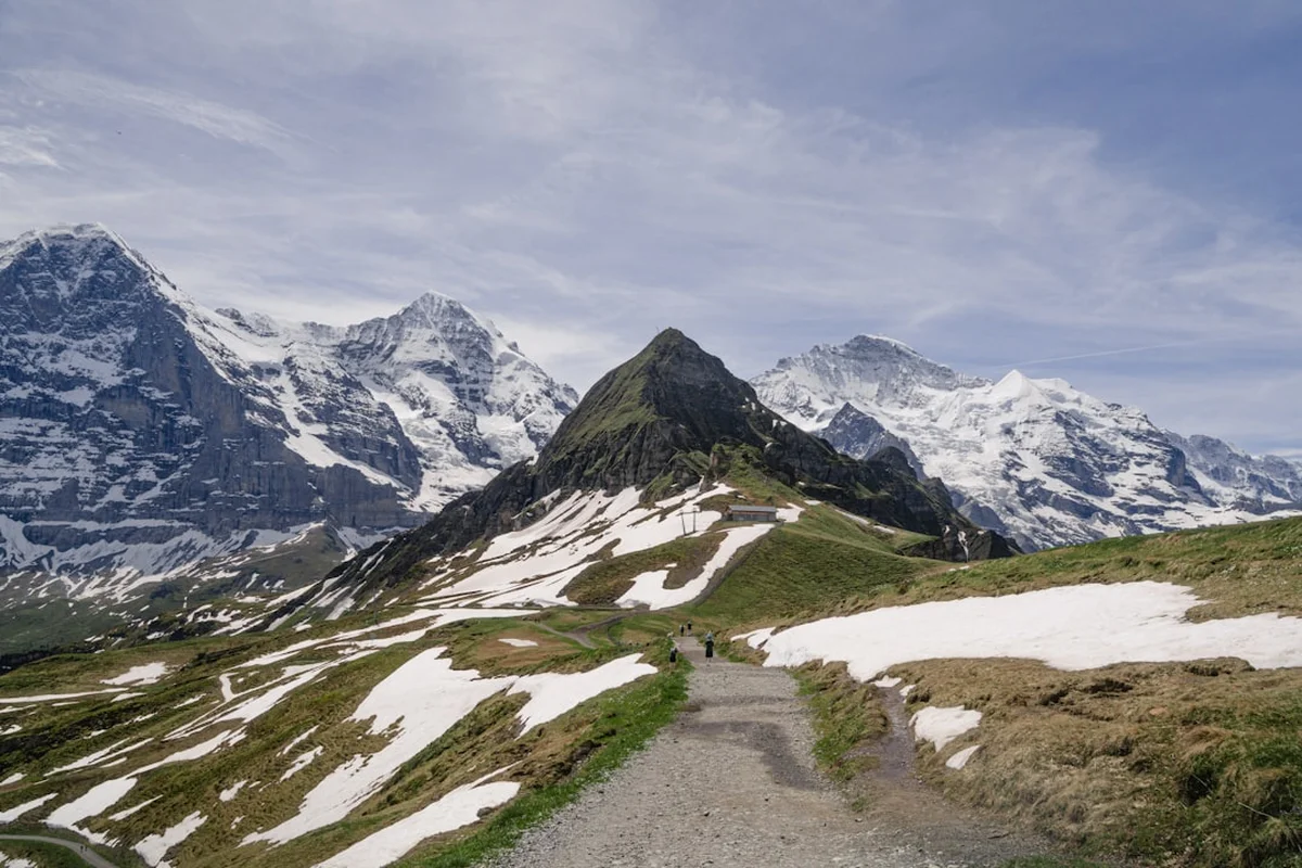
The Walkers Haute Route is the summer trekking version of the legendary "High Level Route," a ski mountaineering traverse first completed in the late 19th century. While the skiers remain on the glaciers, the walkers' route stays primarily on marked trails, though "trail" is often a generous term for the steep, rocky, and sometimes exposed paths that define this trek. The route is characterised by a relentless "yo-yo" profile: every day involves a significant ascent to a high pass followed by a deep descent into a valley. Over the course of the journey, trekkers will accumulate over 12,000 metres of vertical gain—the equivalent of climbing Mount Everest from sea level and then adding another 3,000 metres for good measure.
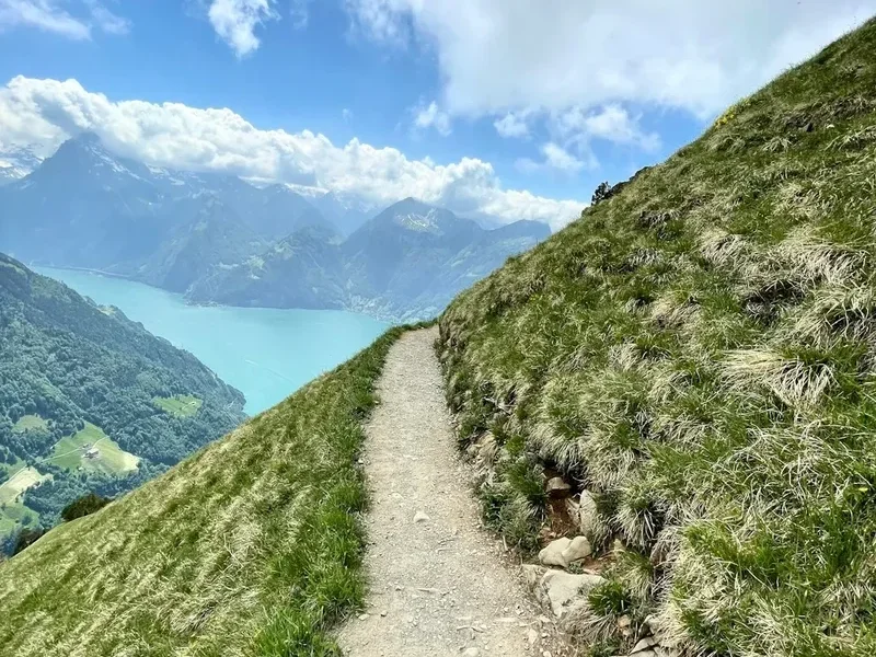
The landscape is a shifting tapestry of ecological zones. You begin in the shadow of the Aiguilles de Chamonix, where granite spires pierce the sky. As you cross into Switzerland, the terrain transitions into the limestone and metamorphic folds of the Valais. You will walk through ancient larch forests, across high alpine meadows (alpages) where the clanging of cowbells provides a constant soundtrack, and over desolate, lunar-like scree slopes where the only signs of life are the occasional marmot or ibex. The proximity to glaciers is a defining feature; at several points, such as the Moiry Glacier or the Otemma Glacier, you are close enough to hear the ice groaning and cracking under the summer sun.
This trek is physically demanding and requires a high level of fitness. There are sections involving steep ladders (the Pas de Chèvres), narrow ridgelines, and unstable boulder fields. However, the rewards are unparalleled. Each pass conquered reveals a new panorama of 4,000-metre peaks, and each evening spent in a remote mountain hut offers a chance to connect with a global community of hikers. The Walkers Haute Route is a journey of contrasts—between the rugged isolation of the high passes and the charming, flower-decked villages of the Swiss valleys. It is a definitive test for any serious trekker and an experience that lingers in the memory long after the final view of the Matterhorn has faded.
History and Cultural Context
The origins of the Haute Route are inextricably linked to the "Golden Age" of mountaineering. In 1861, members of the British Alpine Club, including legendary figures like Francis Fox Tuckett, sought a high-level passage between the two great mountaineering centres of Chamonix and Zermatt. Their original route was almost entirely on ice and snow, requiring technical mountaineering skills and guides. It wasn't until 1911 that the route was first completed on skis, cementing its status as the world's premier ski traverse. The "Walkers" version of the route evolved much later, as hiking trails were developed and linked to allow non-mountaineers to experience the same landscapes without the need for crampons and ropes.
Culturally, the trek is a journey through the heart of the Valais (Wallis) region of Switzerland. This is a land of deep traditions, where the rhythm of life was historically dictated by the seasonal movement of livestock. You will pass through villages like Grimentz and La Sage, where sun-blackened timber granaries (raccards) stand on stone stilts to keep rodents away from the grain. The linguistic transition is also fascinating; you begin in the French-speaking Haute-Savoie, continue through the French-speaking Lower Valais, and finally cross the "Röstigraben"—the invisible cultural and linguistic border—into the German-speaking Upper Valais as you approach Zermatt.
The mountain huts themselves are part of the history. Many are owned by the Swiss Alpine Club (SAC/CAS) and have stood for over a century, evolving from basic stone shelters into modern, sustainably-run hostels. Staying in these huts is a communal experience that has changed little in decades: boots are left at the door, dinner is served at long shared tables, and the "Alpenglow" on the surrounding peaks is the evening's primary entertainment. The Haute Route is not just a physical path; it is a thread that connects the modern hiker to over 150 years of alpine exploration and mountain culture.
Want more background? Read extended notes on history and cultural context → Learn more
Seasonal Highlights and Weather Reality
The window for completing the Walkers Haute Route is relatively narrow, dictated by the melting of winter snow and the arrival of autumn storms. The season typically runs from mid-June to mid-September. Outside of this window, the high passes are often impassable without technical winter equipment and advanced navigation skills.
Early Season (Mid-June to Early July): This is a beautiful but challenging time. The meadows are carpeted in wildflowers—gentians, anemones, and soldanellas—and the waterfalls are at their most powerful. However, significant snow often remains on the north-facing slopes of the higher passes (such as the Fenêtre d'Arpette and Col de Prafleuri). Trekkers must be prepared for "névé" (hard summer snow) and may require micro-spikes or an ice axe. Some higher huts may not be fully open until late June.
High Summer (July and August): This is the most popular time to trek. The weather is generally stable, the trails are clear of snow, and all huts and valley services are in full operation. However, this is also the hottest time of year; temperatures in the valleys can exceed 30 Celsius, making the long climbs gruelling. Afternoon thunderstorms are common in the Alps; these can be violent and develop rapidly, requiring hikers to be off the high passes by early afternoon.
Late Season (September): Many experienced trekkers consider September the best month. The air is crisper and clearer, providing the best visibility for photography. The crowds have thinned, and the autumn colours begin to touch the larch forests. However, the days are shorter, and the risk of an early-season snowfall increases. By mid-September, some mountain huts begin to close for the winter, and the "Bise" (a cold north-easterly wind) can make the high passes feel significantly colder.
Regardless of the month, weather in the Pennine Alps is unpredictable. A sunny morning can transform into a freezing sleet storm within an hour. Proper layering and high-quality waterproof gear are non-negotiable requirements for safety and comfort.
Recommended Itinerary
13-Day Walkers Haute Route Itinerary
Day 1: Chamonix to Argentière
- Distance: 9 km
- Elevation: 400 m gain, 100 m loss
- Time: 3–4 hours
- A gentle start along the "Petit Balcon Sud"
- Views of the Mont Blanc massif and the Mer de Glace
- Stay in Argentière (hotels or gîtes)
- Perfect for testing gear and warming up the legs
Day 2: Argentière to Trient via Col de Balme
- Distance: 13 km
- Elevation: 900 m gain, 900 m loss
- Time: 5–6 hours
- Cross the border from France into Switzerland
- Iconic views back towards Mont Blanc from the Col de Balme (2,191 m)
- Steep descent into the pink-churched village of Trient
- Stay in Trient (Auberge du Mont Blanc)
Day 3: Trient to Champex-Lac via Fenêtre d'Arpette
- Distance: 14 km
- Elevation: 1,400 m gain, 1,200 m loss
- Time: 7–9 hours
- The "High Route" variant and one of the toughest days
- Steep boulder fields leading to the Fenêtre d'Arpette (2,665 m)
- Spectacular views of the Trient Glacier
- Descent to the beautiful lakeside town of Champex-Lac
- Note: The "Bovine" route is a safer, easier alternative in bad weather
Day 4: Champex-Lac to Le Châble
- Distance: 14 km
- Elevation: 100 m gain, 700 m loss
- Time: 4–5 hours
- A "rest" day through the Val de Bagnes
- Pass through traditional Swiss villages and orchards
- Le Châble is the gateway to the Verbier ski area
- Stay in Le Châble (hotels or B&Bs)
Day 5: Le Châble to Cabane du Mont Fort
- Distance: 9 km
- Elevation: 1,600 m gain (or use cable car to reduce gain)
- Time: 5–6 hours
- A massive climb out of the valley
- The trail winds through the Verbier ski slopes but improves as it gains height
- Arrive at Cabane du Mont Fort (2,457 m)
- Incredible sunset views over the Combin Massif
Day 6: Cabane du Mont Fort to Cabane de Prafleuri
- Distance: 14 km
- Elevation: 900 m gain, 400 m loss
- Time: 6–7 hours
- High alpine terrain crossing the Col de Louvie and Col de Prafleuri
- Pass the "Grand Désert" glacier moraine
- Remote and rugged landscape with high chances of seeing ibex
- Stay at the isolated Cabane de Prafleuri (2,662 m)
Day 7: Cabane de Prafleuri to Arolla
- Distance: 16 km
- Elevation: 700 m gain, 1,400 m loss
- Time: 6–7 hours
- Walk alongside the massive Lac des Dix reservoir
- Climb to the Pas de Chèvres (2,855 m) featuring steep metal ladders
- Views of the Mont Collon and the Arolla Glacier
- Descent into the mountaineering village of Arolla
Day 8: Arolla to La Sage
- Distance: 10 km
- Elevation: 200 m gain, 500 m loss
- Time: 3–4 hours
- An easier day through the Val d'Hérens
- Pass through Les Haudères, famous for its traditional timber houses
- Stay in the charming hamlet of La Sage
Day 9: La Sage to Cabane de Moiry
- Distance: 10 km
- Elevation: 1,600 m gain, 400 m loss
- Time: 6–7 hours
- Climb over the Col du Tsaté (2,868 m)
- Descent to the turquoise Lac de Moiry
- Final steep climb to the Cabane de Moiry (2,825 m), perched next to the glacier
- The hut features a modern glass dining room with glacier views
Day 10: Cabane de Moiry to Zinal
- Distance: 14 km
- Elevation: 500 m gain, 1,200 m loss
- Time: 5–6 hours
- Cross the Col de Sorebois (2,838 m)
- Stunning views of the "Imperial Crown"—five 4,000 m peaks surrounding Zinal
- Steep descent into the Val d'Anniviers
- Stay in Zinal (hotels or gîtes)
Day 11: Zinal to Gruben
- Distance: 14 km
- Elevation: 1,200 m gain, 1,100 m loss
- Time: 6–7 hours
- Cross the Forcletta pass (2,874 m)
- Transition from French-speaking to German-speaking Switzerland
- Descent into the remote Turtmanntal valley
- Stay in Gruben (Hotel Schwarzhorn)
Day 12: Gruben to St. Niklaus
- Distance: 16 km
- Elevation: 1,100 m gain, 1,700 m loss
- Time: 7–8 hours
- The final high pass: Augstbordpass (2,894 m)
- Incredible views into the Mattertal
- Long, knee-jarring descent to St. Niklaus
- Stay in St. Niklaus or take a short train to Zermatt
Day 13: St. Niklaus to Zermatt (Europaweg)
- Distance: 18 km
- Elevation: 1,000 m gain, 500 m loss
- Time: 7–8 hours
- The grand finale along the Europaweg
- Cross the Charles Kuonen Suspension Bridge (the world's longest pedestrian suspension bridge)
- Constant views of the Matterhorn as you approach Zermatt
- Finish in the centre of Zermatt
Planning and Bookings
Book Your Trip
Everything you need to plan your journey
Accommodation
Find places to stay near Chamonix
Flights
Search flights to Chamonix
Essential Preparation
The Walkers Haute Route is a serious undertaking that requires months of physical and logistical preparation. Fitness is the most critical factor; you should be comfortable walking 15–20 kilometres a day with a 10–12 kg pack, involving over 1,000 metres of ascent and descent for multiple consecutive days. Training should focus on hill intervals, weighted pack walks, and leg strength (squats and lunges).
Logistically, the route requires careful coordination. Chamonix and Zermatt are well-connected by train and bus, but the intermediate villages have varying levels of transport. It is highly recommended to book your accommodation at least 4–6 months in advance, especially for the popular mountain huts which have limited capacity. Most hikers base themselves in Chamonix for a few days before starting to acclimatise and handle last-minute gear needs.
Trail Accommodation
Accommodation on the Haute Route is a mix of mountain huts (cabanes in Switzerland, refuges in France), valley gîtes (hostels), and hotels. The experience of staying in a high-altitude hut is a highlight of the trip.
Hut Facilities:
- Dormitory-style sleeping (usually 4 to 12 people per room)
- Half-board (dinner and breakfast) is standard and highly recommended
- Common areas for socialising and drying gear
- Shared bathrooms (showers are often extra cost and limited to 2–3 minutes)
- Blankets and pillows are provided, but a silk or cotton sleeping bag liner is mandatory
- Charging stations are often available but can be crowded; bring a power bank
What is NOT Provided:
- Towels and toiletries
- Personal sleeping bags (liners only)
- Free drinking water (in some high huts, water must be purchased or treated)
- Private rooms (rare in high huts, more common in valley gîtes)
Costs: Expect to pay between 80 and 110 Swiss Francs (CHF) per night for half-board in a mountain hut. Valley hotels in Chamonix or Zermatt will be significantly more expensive.
Required Gear
- Footwear: High-quality trekking boots with excellent ankle support and a stiff sole (Vibram or similar). They must be thoroughly broken in before the trip.
- Clothing: A versatile layering system. Merino wool base layers, a fleece or down mid-layer, and a high-quality Gore-Tex waterproof jacket and overtrousers.
- Pack: A 35–45 litre backpack is usually sufficient if staying in huts. Ensure it has a high-quality hip belt and a rain cover.
- Navigation: Topographic maps (1:25,000 scale), a compass, and a GPS device or smartphone with offline maps (e.g., Outdooractive or Gaia GPS).
- Safety: A basic first aid kit (focus on blister care), an emergency whistle, and a space blanket.
- Trekking Poles: Highly recommended to save your knees on the 12,000 m of descent.
What to Bring
- Water Treatment: A lightweight filter (like a Sawyer Squeeze) or purification tablets, as stream water may be contaminated by livestock.
- Sun Protection: High-factor sunscreen (SPF 50+), lip balm with UV protection, sunglasses (Category 3 or 4), and a wide-brimmed hat. The alpine sun is exceptionally strong.
- Toiletries: Biodegradable soap/shampoo, a lightweight travel towel, and earplugs (essential for dorm sleeping).
- Cash: Swiss Francs (CHF) and Euros (EUR). Many remote huts do not accept credit cards or have unreliable connections.
- Snacks: High-energy bars, nuts, and dried fruit. While lunch can be bought at huts, having your own supplies is essential for the long passes.
- Sleeping Liner: A silk or cotton liner is mandatory for hygiene in all mountain huts.
Permits

One of the great advantages of the Walkers Haute Route is that no official permits are required to walk the trail or cross the borders between France and Switzerland. The mountains are open to all. However, the "permit" in a practical sense is your accommodation booking. Because wild camping is strictly regulated and often prohibited along much of the route, your ability to complete the trek depends entirely on securing a bed in the huts or hotels.
Booking Strategy:
- Swiss Alpine Club (SAC/CAS): Most huts can be booked through a central online portal. Create an account early.
- Timing: Bookings for the summer season typically open in January or February. For peak July/August dates, you should book as soon as the system opens.
- Flexibility: If a hut is full, look for "variants." For example, if the Cabane de Prafleuri is full, you might be able to stay at the Auberge du Chargeur at the base of the dam, though this adds elevation the next day.
- Cancellations: If you cannot make a booking, check back frequently. Cancellations do happen, especially 48–72 hours before a date when the weather forecast becomes clear.
Border Formalities: While both France and Switzerland are part of the Schengen Area, you should always carry a valid passport or national ID card. You will cross the border at the Col de Balme; while there is rarely a guard present, random checks can occur in the valleys.
Insurance: While not a permit, mountain rescue insurance is effectively mandatory. If you require a helicopter evacuation in the Swiss Alps, the costs can exceed 5,000 CHF. Ensure your travel insurance specifically covers "hiking up to 3,000 metres" and "search and rescue." Membership in an Alpine Club (like the Austrian Alpine Club UK) often includes excellent rescue insurance.
Other Activities in the Area
The regions surrounding Chamonix and Zermatt offer some of the finest mountain experiences in the world. Consider adding a few days to your itinerary to explore:
- Aiguille du Midi (Chamonix): Take the highest vertical ascent cable car in the world to 3,842 m for a staggering view of the Mont Blanc summit and the glaciers below.
- Gornergrat Railway (Zermatt): A cogwheel train that takes you to 3,089 m for the definitive view of the Matterhorn and the Monte Rosa massif.
- Thermal Baths (Saillon or Lavey-les-Bains): After 13 days of trekking, soaking your muscles in the natural thermal waters of the Valais is the ultimate luxury.
- Wine Tasting in the Valais: The valley between Martigny and Sion is one of Switzerland's premier wine regions. Try the local Fendant (white) or Dôle (red).
- Via Ferrata: For those with energy left, there are spectacular via ferrata routes in Mauvoisin and Zermatt that offer a more vertical challenge.
- Paragliding: Both Chamonix and Zermatt are world-class hubs for tandem paragliding, offering a bird's-eye view of the trails you've just walked.
Safety and Conditions
Alpine Weather: The greatest objective hazard on the Haute Route is the weather. Conditions can change from benign to life-threatening in minutes. Always check the MeteoSwiss app or the local "Météo Chamonix" forecast before setting out. If lightning is forecast, ensure you are off the high passes and away from metal ladders (like the Pas de Chèvres) by midday.
Terrain and Exposure: While the route is a "walk," it involves significant exposure. Sections like the Europaweg or the descent from the Fenêtre d'Arpette involve narrow paths with steep drops. If you suffer from severe vertigo, some variants may be challenging. The Pas de Chèvres ladders are vertical but well-maintained; however, they can be slippery when wet.
Snow and Ice: Even in mid-summer, you may encounter patches of old snow. If the snow is hard and frozen (common in the morning), it can be extremely slippery. Trekking poles are essential for stability, and in early July, micro-spikes are a wise addition to your pack.
Navigation: While the trails are generally well-marked with yellow signs and red-and-white paint blazes, fog can reduce visibility to a few metres. You must be competent with a map and compass or a GPS. Do not rely solely on a smartphone, as batteries drain quickly in the cold and signal is non-existent in many high basins.
Hydration and Altitude: You will be spending much of your time between 2,000 m and 3,000 m. Altitude sickness is rare at these heights but can manifest as headaches or nausea. Drink plenty of water (3 litres per day) and avoid excessive alcohol in the huts. Be aware that many high-altitude streams are downstream from summer cattle pastures; always treat your water.
Side Trips and Points of Interest
Fenêtre d'Arpette: This is the "high variant" of Day 3 and is widely considered the most spectacular viewpoint on the entire trek. The "window" (fenêtre) is a narrow notch in a granite ridge that looks directly down onto the chaotic icefall of the Trient Glacier. It is a steep, arduous climb, but the transition from the lush Arpette valley to the raw glacial world is unforgettable.
The Charles Kuonen Suspension Bridge: Located on the final leg into Zermatt, this 494-metre-long bridge hangs 85 metres above the Grabengufer ravine. It is a feat of Swiss engineering and offers a thrilling (if slightly nerve-wracking) experience with the Matterhorn framed perfectly in the distance.
Lac des Dix and Grande Dixence Dam: On Day 7, you walk alongside the largest gravity dam in the world. Standing 285 metres high, it is a staggering sight. The trail along the lake is flat and easy, providing a rare mental break before the climb to the Pas de Chèvres.
Moiry Glacier: The Cabane de Moiry is one of the most spectacularly situated huts in the Alps. A short 20-minute walk from the hut takes you to the edge of the Moiry Glacier, where you can observe the blue ice and crevasses up close. The hut's dining room, with its floor-to-ceiling windows, offers a "cinema view" of the ice.
The Europaweg: This final two-day stretch into Zermatt is often cited as the most beautiful balcony walk in the Alps. It stays high above the Mattertal valley, offering constant views of the 4,000 m peaks of the Weisshorn and the Zinalrothorn, culminating in the first reveal of the Matterhorn.
Leave No Trace
The Alps are a heavily used but fragile ecosystem. With thousands of hikers traversing the Haute Route every summer, the cumulative impact can be significant. It is the responsibility of every trekker to preserve this landscape for future generations.
Core Principles for the Haute Route:
- Pack it in, Pack it out: There are no rubbish bins in the mountain huts. You must carry all your trash (including fruit peels and tissues) down to the valley villages.
- Respect the Alpages: You will often walk through active grazing lands. Close all gates behind you and keep a respectful distance from the Hérens cattle—they are generally docile but can be protective of their calves.
- Stay on the Path: Cutting switchbacks causes severe erosion, especially on the steep, friable soil of the high passes. Stick to the marked trail even if it is muddy or rocky.
- Wild Camping: In Switzerland, wild camping is generally prohibited above the treeline in many cantons and strictly forbidden in nature reserves. Always use designated campsites or huts.
- Water Protection: Do not use soap (even biodegradable) in alpine lakes or streams. The cold water and sensitive ecosystems cannot break down the chemicals effectively.
- Wildlife: Observe marmots, chamois, and ibex from a distance. Never feed them, as it disrupts their natural foraging behaviour and preparation for the harsh winter.