Waiheke Island Coastal Walk - A Journey Through the Island of Wine and Waves
The Waiheke Island Coastal Walk is a premier day-hiking experience located in the Hauraki Gulf, just a short ferry ride from the bustling centre of Auckland. Spanning approximately 25 kilometres of diverse terrain, this walk forms a significant portion of the "Te Ara Hura" network—a series of interconnected trails that circumnavigate the island. The route offers an unparalleled blend of rugged coastal cliffs, pristine white-sand beaches, ancient native forest, and world-class vineyards. Starting and ending at the Matiatia Wharf, the trail provides walkers with a comprehensive overview of the island's natural beauty and cultural charm. This is not merely a walk; it is an immersion into the relaxed "island time" philosophy, where the rhythm of the tides and the rustle of the silver ferns dictate the pace of the day. Whether you are seeking a physical challenge or a scenic escape, the Waiheke Island Coastal Walk delivers a world-class outdoor experience within sight of New Zealand's largest city.
- Distance: 25.0 km loop
- Duration: 6–8 hours
- Season: October–April (Spring to Autumn)
- Difficulty: Moderate (mixed terrain with some steep coastal ascents)
- Highest point: Approximately 150 m (various coastal headlands)
- Start/Finish: Matiatia Wharf, Waiheke Island
- Direction: Clockwise or anti-clockwise (clockwise recommended for morning light on northern beaches)
Overview
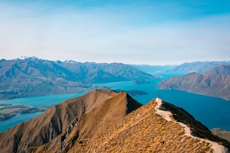
Waiheke Island, often referred to as the "Jewel of the Hauraki Gulf," provides a dramatic backdrop for one of New Zealand's most accessible yet rewarding coastal treks. The 25-kilometre coastal walk is a masterclass in topographical variety. The journey begins with the "Headlands" section, where the trail hugs the western cliffs of the island, offering sweeping views back across the Motutapu and Rangitoto channels toward the Auckland skyline. Here, the path is often narrow and winds through regenerating native bush and open pasture, where sheep graze against a backdrop of turquoise water.
As the trail progresses toward the northern coastline, the landscape shifts from rugged cliffs to a series of idyllic bays. Walkers will traverse the golden sands of Oneroa, Little Oneroa, Enclosure Bay, and Palm Beach. Each bay has its own distinct character, from the vibrant village atmosphere of Oneroa to the secluded, rocky outcrops of Enclosure Bay, which resembles a natural swimming pool at high tide. The terrain involves a constant "up and down" rhythm as the trail climbs over headlands to drop into the next valley, ensuring that hikers are rewarded with fresh perspectives of the Pacific Ocean at every turn.
The final major stretch takes walkers along the expansive Onetangi Beach, a 1.8-kilometre crescent of white sand that serves as the island's most iconic coastal landmark. From here, the route turns inland or continues along the southern coastal tracks to return to Matiatia. The walk is physically demanding due to its length and the cumulative elevation gain of approximately 600 metres, but the availability of local cafes, public toilets, and bus stops along the route allows for a highly customisable experience. It is a trail that balances the wildness of the New Zealand coast with the sophisticated amenities of a world-renowned travel destination.
History and Cultural Context
The history of Waiheke Island is deeply intertwined with the story of the Hauraki Gulf and the wider Tāmaki Makaurau (Auckland) region. For Māori, the island is known as "Te Motu-arai-roa" (the long sheltering island) and "Waiheke" (cascading waters). The island has been inhabited for nearly a thousand years, primarily by the Ngāti Paoa iwi (tribe), who recognise the land as their ancestral home. The coastal routes used by modern hikers often follow the same paths used by Māori for centuries to access kaimoana (seafood) and to move between fortified pā (villages) situated on strategic headlands. Evidence of these ancient settlements, including middens and terraced hillsides, can still be seen by the observant walker along the western cliffs.
European settlement in the mid-19th century brought significant changes to the island's landscape. Much of the original heavy forest was cleared for timber and later for pastoral farming. For many decades, Waiheke was a quiet agricultural outpost, known for its sheep and cattle runs. However, the mid-20th century saw a shift as the island became a retreat for artists, bohemians, and those seeking an alternative lifestyle away from the city. This "counter-culture" heritage remains a core part of the island's identity today, reflected in the numerous galleries and community-led conservation projects found along the trail.
In the late 1970s and 1980s, the island underwent another transformation with the introduction of viticulture. The unique microclimate—characterised by higher temperatures and lower rainfall than mainland Auckland—proved ideal for growing Bordeaux-style grapes. Today, the trail passes through or alongside some of New Zealand's most prestigious vineyards. The "Te Ara Hura" trail network, which includes this coastal walk, was officially inaugurated to connect these historical, cultural, and natural sites, ensuring that the island's heritage is preserved and shared with every visitor who sets foot on the path.
Want more background? Read extended notes on history and cultural context → Learn more
Seasonal Highlights and Weather Reality
The Waiheke Island Coastal Walk is accessible year-round, but the experience changes significantly with the seasons. The peak period from October to April offers the most stable weather and the warmest temperatures, making it ideal for those who wish to combine their hike with a swim in the many bays along the route.
Spring (September–November): This is arguably the best time for the walk. The native kōwhai trees are in bloom, splashing the coastal cliffs with vibrant yellow flowers that attract nectar-feeding birds like the tūī and bellbird. Temperatures are mild, typically ranging from 15°C to 20°C, which is perfect for a long-distance day hike. The trail is also less crowded than in the height of summer.
Summer (December–February): Summer brings the most sunshine and the highest temperatures (often reaching 25°C–28°C). The pōhutukawa trees, known as New Zealand's Christmas trees, bloom in brilliant crimson along the shoreline. While the scenery is spectacular, the heat can be intense on the exposed headland sections. Walkers must carry extra water and apply high-factor sunscreen frequently. The island is at its busiest during this time, so expect more foot traffic near the main beaches.
Autumn (March–May): As the heat of summer fades, autumn brings settled weather and crisp, clear days. The sea remains warm enough for swimming well into March. The light during autumn is particularly beautiful for photography, with golden hues reflecting off the dry grasses on the western cliffs.
Winter (June–August): While the trail remains open, winter can bring muddy conditions, particularly in the forested sections. Temperatures average 10°C–14°C. However, on a calm, sunny winter day, the visibility across the Hauraki Gulf is often at its sharpest, and you will have the trail almost entirely to yourself. Some sections of the Te Ara Hura may be slippery, so sturdy footwear is essential.
Recommended Itinerary
Waiheke Coastal Loop Itinerary
Early Morning: Matiatia to Oneroa Village
- Distance: 5 km
- Time: 1.5 hours
- Start at Matiatia Wharf after arriving on the ferry from Auckland
- Follow the "Headlands" track clockwise toward Church Bay
- Ascent through regenerating bush to the western ridgeline
- Spectacular views of Motutapu Island and the Auckland skyline
- Descend into the western end of Oneroa Beach
- Walk along the sand or the cliff-top path to Oneroa Village
- Stop for a coffee or breakfast at one of the many cafes overlooking the bay
Morning: Oneroa to Palm Beach
- Distance: 7 km
- Time: 2 hours
- Continue east from Little Oneroa Beach
- The trail becomes more rugged, traversing the cliffs above Enclosure Bay and Sandy Bay
- Pass through the Newton Reserve, a beautiful patch of native forest
- Navigate the rocky shoreline at low tide or follow the high-tide road bypass
- Arrive at Palm Beach, a perfect spot for a mid-morning rest
- Public toilets and water refill stations are available at the Palm Beach reserve
Midday: Palm Beach to Onetangi
- Distance: 6 km
- Time: 1.5–2 hours
- Climb the steep stairs at the eastern end of Palm Beach to the headland
- Follow the trail through the Mawhitipana Reserve
- Enjoy panoramic views of the northern coastline and the distant Coromandel Peninsula
- Descend into the western end of Onetangi Beach
- Walk the full 1.8 km length of Onetangi Beach
- Lunch at one of the beachfront restaurants or a picnic on the dunes
Afternoon: Onetangi to Matiatia (Return via Interior or South Coast)
- Distance: 7 km
- Time: 2 hours
- Option A: Follow the interior "Forest Heart" tracks through Whakanewha Regional Park (adds distance)
- Option B: Take the direct route back via the central ridgeline roads and vineyards
- Option C: Catch the local bus from Onetangi back to Matiatia Wharf if legs are tired
- If walking, pass through the vineyards of the central valley
- Final descent back to Matiatia Wharf in time for the evening ferry
- Enjoy the sunset over the Hauraki Gulf during the return boat journey
Important Notes:
- The 25 km distance covers the primary coastal highlights; shorter loops are easily organised
- Check tide charts before departure—some beach sections are easier at low tide
- The trail is well-marked with "Te Ara Hura" signage (look for the circular markers)
- Public buses run frequently between Onetangi, Palm Beach, Oneroa, and the ferry
- Mobile phone coverage is generally excellent across the entire island
- Always clean your boots at the Kauri Dieback stations to protect native trees
Planning and Bookings
Book Your Trip
Everything you need to plan your journey
Accommodation
Find places to stay near Auckland
Flights
Search flights to Auckland
Essential Preparation
Planning for the Waiheke Island Coastal Walk is relatively straightforward compared to New Zealand's multi-day Great Walks, but it still requires coordination. The most critical logistical element is the ferry transfer. Ferries depart from the Auckland Ferry Terminal (99 Quay Street) approximately every 30 to 60 minutes. No pre-booking is strictly required for foot passengers, but arriving 20 minutes early during summer weekends is highly recommended. The journey takes roughly 40 minutes.
Fitness is a key consideration. While the trail is not technically difficult, walking 25 kilometres with 600 metres of elevation gain is a significant physical undertaking. Ensure you have completed at least one or two 15-kilometre walks in the weeks leading up to your trip. There is no "base town" other than Auckland itself, though Oneroa serves as the island's main hub for supplies and last-minute gear.
Trail Accommodation
This is a day hike requiring no overnight accommodation on the trail itself. Camping is strictly prohibited in most public reserves and along the coastline of Waiheke Island. However, for those wishing to break the walk into two days, the island offers a vast array of accommodation options ranging from luxury lodges and boutique vineyard stays to backpacker hostels and holiday rentals (baches).
Accommodation Options:
- Oneroa: Numerous high-end rentals and small hotels within walking distance of the trail.
- Onetangi: Beachfront apartments and a popular backpacker hostel.
- Whakanewha Regional Park: The only official DOC-style campsite on the island (requires booking via Auckland Council). It is located on the southern coast, roughly 4 km from the main coastal route.
- Booking: If staying overnight, book well in advance for summer months (December–February) as the island frequently reaches 100% occupancy.
Required Gear
- Footwear: Sturdy walking shoes or light hiking boots. While some sections are on sand or pavement, the headland tracks are uneven and can be slippery when wet.
- Sun Protection: A wide-brimmed hat, high-SPF sunscreen, and quality sunglasses. The New Zealand sun is exceptionally harsh due to low pollution and thin ozone.
- Clothing: Lightweight, moisture-wicking layers. Avoid denim. A lightweight windbreaker or rain jacket is essential, even if the forecast is clear.
- Daypack: A 15–25L pack with a comfortable harness to carry your water, food, and spare layers.
- Navigation: A charged smartphone with an offline map (such as AllTrails or the Auckland Council path maps). A physical map can be picked up at the Matiatia Information Centre.
What to Bring
- Water: At least 2 litres per person. While there are refill stations in Oneroa, Palm Beach, and Onetangi, the headland sections are exposed and have no water access.
- Food: High-energy snacks (nuts, dried fruit, chocolate) and a substantial lunch. While cafes exist, they are concentrated in specific villages; you may be 2 hours away from the nearest food source at any given time.
- First Aid: Blister plasters (essential for a 25 km walk), antiseptic wipes, and any personal medications.
- Swimming Gear: A lightweight towel and swimwear if you plan to cool off in the ocean.
- Power Bank: To ensure your phone remains charged for navigation and photos.
- Rubbish Bag: To carry out all your waste, as bins are not provided on the bush sections of the trail.
Permits
No permits or fees are required to walk the Waiheke Island Coastal Walk or any part of the Te Ara Hura network. The trails are free and open to the public year-round. This makes it one of the most cost-effective world-class hiking experiences in the Auckland region.
Logistical Costs to Consider:
- Ferry Fare: A return adult ticket from Auckland to Matiatia costs approximately NZ$50–$60 depending on the operator (Fullers360 or Island Direct). Discounts are often available for children, seniors, and those using an AT HOP card.
- Public Transport: If you choose to walk only one way and return by bus, a one-way fare is approximately NZ$4–$6. You can use an AT HOP card (the same system used in Auckland city).
- Parking: If driving to the Auckland Ferry Terminal, parking in the downtown car parks can be expensive (NZ$40–$60 per day). It is often cheaper to take a bus or train to the Britomart Transport Centre, which is a 5-minute walk from the ferry.
Group Access: While individual walkers do not need permits, large organised groups (e.g., commercial tours or events with more than 20 people) may require a permit from the Auckland Council to ensure that the environmental impact is managed and that other trail users are not inconvenienced.
Other Activities in the Area
Waiheke Island is a multi-faceted destination. If you have extra time before or after your walk, consider these popular activities:
- Wine Tasting: Waiheke is world-famous for its syrah and cabernet blends. Visit renowned estates like Mudbrick, Cable Bay, or Casita Miro for a tasting session with a view.
- Eco-Ziplining: For an adrenaline rush, EcoZip Adventures offers zipline tours over native forest with views of the Hauraki Gulf, located near the centre of the island.
- Art Galleries: Explore the Waiheke Community Art Gallery in Oneroa or visit the Connells Bay Sculpture Park (requires booking) to see large-scale works by New Zealand artists.
- Sea Kayaking: Rent a kayak at Matiatia or Oneroa to explore the coastline from a different perspective, visiting sea caves and hidden coves inaccessible by foot.
- Stony Batter Historic Reserve: Located at the eastern end of the island, this reserve features a network of World War II tunnels and gun emplacements (check opening times for tunnel tours).
- Olive Oil Tasting: Visit Rangihoua Estate to sample award-winning extra virgin olive oils grown and pressed on the island.
Safety and Conditions
Terrain and Footing: The coastal tracks can be narrow and uneven. After rain, the clay-based soil becomes extremely slippery. Take particular care on the steep descents into Church Bay and Palm Beach. Always stay on the marked trail; the cliff edges are prone to erosion and can be unstable.
Weather Exposure: Much of the 25 km route is highly exposed to the elements. There is very little shade on the western headlands. Heat exhaustion and dehydration are genuine risks in summer. Conversely, the island can experience sudden coastal squalls. Always check the MetService forecast for "Auckland - Waiheke Island" before departing.
Tides: Some sections of the coastal walk, particularly between Little Oneroa and Palm Beach, involve walking along the shoreline. At high tide, these sections may be impassable, requiring a detour onto local roads. Check the Matiatia tide chart before you start. A general rule is to attempt beach sections within 2 hours of low tide.
Kauri Dieback: This is a critical safety and environmental issue in New Zealand. Kauri dieback is a soil-borne disease that kills our ancient kauri trees. You will encounter cleaning stations at the entrance and exit of forested sections. You MUST scrub all soil off your boots and spray them with the provided disinfectant. This is a legal and ethical requirement to protect the forest.
Emergency Services: In the event of an emergency, dial 111. While the island feels remote, it has a permanent police station and a medical centre in Oneroa. Mobile reception is reliable, but ensure your battery is managed carefully.
Side Trips and Points of Interest
Whakanewha Regional Park: If you wish to extend your walk, a detour into Whakanewha offers a completely different ecosystem. This southern park features mature coastal forest, a large wetland area, and a significant breeding ground for the endangered New Zealand dotterel. The "Nikau Track" within the park is particularly beautiful, winding through a dense grove of native palms.
Enclosure Bay: Often missed by those rushing to Palm Beach, Enclosure Bay is a geological marvel. A semi-circle of rock stacks protects the bay from the ocean's swell, creating a calm, shallow lagoon that is perfect for snorkeling. It is a quiet, local favourite and a great place to spot small fish and occasionally rays in the clear water.
The Cascades: Located in the middle of the island within the Cascades Shared Path, this area features a series of small waterfalls and a tranquil stream. It provides a cool, shaded alternative to the coastal heat and is a great place to see the giant pūriri trees that once covered the entire island.
Fisherman’s Rock: A short, steep detour near the western headlands leads down to a popular local fishing spot. The rock formations here are dramatic, and it is a fantastic place to watch the large container ships and cruise liners navigating the deep-water channel into Auckland Harbour.
Leave No Trace
Waiheke Island is a fragile ecosystem under constant pressure from high visitor numbers. Practising Leave No Trace principles is essential to ensure the island remains a paradise for future generations. The island community is deeply committed to conservation, and walkers are expected to share this responsibility.
Your responsibility as a walker:
- Pack it in, pack it out: There are no rubbish bins on the trails. Take all your food scraps, wrappers, and fruit peels back to the mainland or to your accommodation. Even "biodegradable" items like orange peels can take years to decompose in this environment and attract pests.
- Respect Wildlife: You may encounter nesting shorebirds like the variable oystercatcher or the dotterel. Give them a wide berth (at least 20 metres) and never approach their nests, which are often just simple scrapes in the sand.
- Stay on the Track: Short-cutting corners causes erosion and destroys the delicate root systems of native plants.
- Kauri Protection: As mentioned, use the cleaning stations. This is the single most important thing you can do for the New Zealand forest.
- Water Conservation: Waiheke relies on rainwater harvesting. Use public water refill stations sparingly and never waste water.
- Toilets: Use the public toilets provided in the villages and at the main beaches. Do not "go" in the bush, as this contaminates the local waterways and the ocean.