Waiau Pass Route - Alpine Wilderness Adventure
The Waiau Pass Route is a challenging multi-day trek through the heart of New Zealand's Southern Alps, offering a true alpine wilderness experience. This route traverses rugged mountain terrain, crosses the formidable Waiau Pass, and provides breathtaking vistas of glacial lakes, snow-capped peaks, and remote valleys. It is a journey for experienced trampers seeking solitude and a profound connection with the raw beauty of the high country. Unlike more manicured tracks, the Waiau Pass Route demands self-sufficiency, robust navigation skills, and a high level of fitness. It is a route that rewards perseverance with unparalleled scenic grandeur and a deep sense of accomplishment.
- Distance: 65.0 km
- Duration: 4-6 days
- Season: December to March (New Zealand summer)
- Difficulty: Challenging
- Highest point: Waiau Pass (approx. 1800 m)
- Accommodation: Basic backcountry huts and potential for camping
- Direction: Typically traversed from north to south, or vice versa, depending on access and preference.
- Closest City: Nelson
Overview
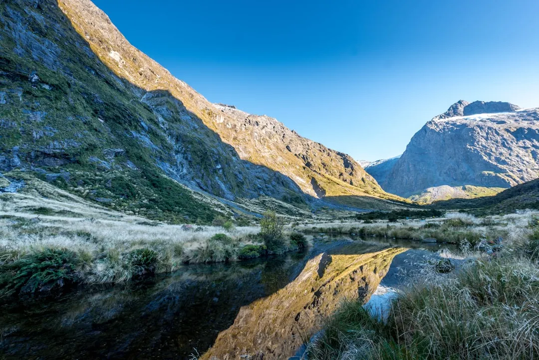
The Waiau Pass Route is a demanding but immensely rewarding trek that winds through some of New Zealand's most spectacular alpine scenery. Beginning near the tranquil shores of Lake Rotoiti or Lake Rotoroa, the track gradually ascends through native beech forests before emerging into the subalpine and alpine zones. The highlight of the journey is the crossing of Waiau Pass, a high alpine saddle that offers panoramic views of the surrounding mountain ranges, including the rugged peaks of the Spenser Mountains and the distant Southern Alps. The descent often leads through tussock-covered slopes and scree fields, eventually returning to the forested valleys.
This route is characterised by its remoteness and the wild, untamed nature of the landscape. It is not a Great Walk and therefore sees significantly fewer people, offering a genuine sense of isolation. The weather in the alpine regions can be unpredictable and change rapidly, with snow possible even in summer. This necessitates careful planning, appropriate gear, and a flexible attitude. The route is best suited for those who are comfortable with off-track navigation, steep ascents and descents, and the challenges of alpine environments.
The journey typically involves several days of strenuous hiking, with ascents and descents that test physical endurance. The views from the higher elevations are spectacular, encompassing vast glacial valleys, turquoise lakes, and jagged peaks. The flora and fauna are typical of the high country, with hardy alpine plants and the chance to spot native birds. The Waiau Pass Route is an adventure for those who crave the wild and are prepared to embrace the challenges that come with it.
History and Cultural Context
The alpine regions traversed by the Waiau Pass Route have a long history of human use, primarily by Māori for seasonal hunting and travel. The network of valleys and passes provided access to important resources and facilitated movement between different tribal territories. The Waiau River itself, which the route often follows or crosses, is a significant waterway in the region, named by Māori for its "wide waters."
European exploration and settlement in the late 19th and early 20th centuries saw the development of tracks for access to mining, logging, and later, for recreational purposes. The establishment of national parks and reserves in the mid-20th century helped to preserve these areas for future generations. The Waiau Pass Route, while not a formally designated "Great Walk," has been used by trampers for decades, evolving from rough routes to more defined, albeit still challenging, tracks.
The area is part of the wider Southern Alps, a region of immense geological significance, shaped by glaciation over millennia. The Māori cultural heritage of the region is deeply intertwined with the land, and the names of rivers, mountains, and valleys often reflect this connection. Understanding this history adds a layer of appreciation to the journey, recognising that these landscapes have been traversed and valued for centuries.
Seasonal Highlights and Weather Reality
The prime season for tackling the Waiau Pass Route is during the New Zealand summer, from December to March. During these months, the days are longer, and the weather is generally more stable, although still highly variable in the alpine environment.
Summer (December to March): This period offers the best chance of snow-free passes and more predictable weather. The alpine meadows may be in bloom, and the long daylight hours allow for extended hiking days. However, summer can also bring thunderstorms, strong winds, and sudden drops in temperature. Snow can persist on higher passes well into December and can fall again in March. Sandflies can be prevalent, especially in lower-lying forested areas and near water sources.
Shoulder Seasons (November and April): These months can offer a quieter experience with fewer people. However, the weather is significantly more unpredictable. Snowfall is more likely, and passes may be impassable. Navigation can be more challenging due to snow cover. These seasons are best suited for experienced trampers with excellent winter navigation skills and appropriate gear.
Winter (May to October): The Waiau Pass Route is generally considered impassable and extremely dangerous during winter. Heavy snowfall, ice, avalanches, and extreme cold make it a route for highly experienced mountaineers only, requiring specialised equipment and skills. Most trampers avoid this route during the winter months.
Regardless of the season, it is crucial to check the weather forecast immediately before and during your trip. Fiordland and the Southern Alps are notorious for their rapidly changing weather conditions.
Recommended Itinerary
4-6 Day Waiau Pass Route Itinerary (North to South Example)
Day 1: Lake Rotoiti to Lakehead Hut
- Distance: 16 km
- Elevation gain: 200 m
- Time: 4–5 hours
- Start at the Lake Rotoiti trailhead (near St Arnaud).
- Follow the well-formed track along the western shore of Lake Rotoiti.
- Pass through native beech forest, with occasional views of the lake.
- Arrive at Lakehead Hut, a popular DOC hut at the northern end of Lake Rotoroa.
- This is a relatively easy start to acclimatise and enjoy the lakeside scenery.
Day 2: Lakehead Hut to Speargrass Hut
- Distance: 18 km
- Elevation gain: 600 m
- Time: 6–7 hours
- The track begins to climb more steadily away from the lake.
- Ascend through beech forest, with sections of open tussock land.
- Cross the Speargrass Creek and follow its valley upstream.
- Arrive at Speargrass Hut, a basic backcountry hut.
- This day involves significant elevation gain, preparing you for the higher country.
Day 3: Speargrass Hut to Waiau Pass Hut (or nearby campsite)
- Distance: 14 km
- Elevation gain: 800 m
- Time: 6–8 hours
- This is a challenging day, involving a steep ascent to Waiau Pass.
- The track becomes rougher and less defined in places.
- Navigate through alpine tussock fields and scree slopes.
- Reach Waiau Pass (approx. 1800 m), offering spectacular panoramic views.
- Descend slightly to Waiau Pass Hut, a small, basic shelter, or find a suitable campsite nearby.
- This day requires good navigation skills and fitness.
Day 4: Waiau Pass Hut to Boyle Village (or nearby campsite)
- Distance: 17 km
- Elevation loss: 1000 m
- Time: 6–7 hours
- A long descent from the pass, often on steep and sometimes loose terrain.
- Follow the Boyle River valley downstream.
- The landscape transitions from alpine to subalpine and eventually to beech forest.
- Arrive at Boyle Village, which has basic facilities and a DOC campsite.
- Alternatively, camp at designated spots along the river if preferred and conditions allow.
Optional Day 5: Rest Day or Exploration
- A rest day at Boyle Village or a nearby campsite can be beneficial.
- Explore the surrounding area, or enjoy a slower pace.
- This day adds flexibility for weather delays or personal preference.
Optional Day 6: Boyle Village to St Arnaud (or onward travel)
- Distance: Variable (depending on transport arrangements)
- Time: Variable
- Arrange transport from Boyle Village back to St Arnaud or your next destination.
- This can involve pre-booked shuttles or private arrangements.
Important Notes:
- This itinerary is a guideline; actual times and distances may vary based on conditions and individual pace.
- Hut bookings are generally not required for these backcountry huts, but it's advisable to check DOC guidelines.
- Camping is permitted in designated areas or where appropriate, following Leave No Trace principles.
- Weather can significantly impact travel times and safety. Be prepared to alter your plans.
- Navigation is critical, especially on Day 3 and Day 4. Carry a map, compass, and GPS device, and know how to use them.
Planning and Bookings
Book Your Trip
Everything you need to plan your journey
Accommodation
Find places to stay near Nelson
Flights
Search flights to Nelson
Essential Preparation
The Waiau Pass Route is a serious undertaking that requires thorough preparation. Unlike the Great Walks, there are no mandatory booking systems for the huts along this route, but this means you must be self-sufficient and prepared for all conditions. The closest major city for supplies and transport is Nelson. From Nelson, you can drive or take a bus to St Arnaud, the typical starting point for the northern section of the route. St Arnaud offers basic amenities, including a general store and accommodation options, and is the gateway to the Nelson Lakes National Park.
Logistics are key. You will need to arrange transport to the trailhead and from the exit point. This often involves a combination of driving, shuttle services, or hitchhiking, depending on your chosen direction and access points. Consider the time of year carefully, as weather is the most significant factor influencing safety and enjoyment. Ensure you have a reliable communication device, such as a personal locator beacon (PLB), as mobile phone coverage is non-existent for most of the route.
Trail Accommodation
The Waiau Pass Route features a mix of basic backcountry huts and opportunities for camping. These facilities are managed by the Department of Conservation (DOC) and are designed for self-sufficient trampers.
Huts:
- Lakehead Hut: A standard DOC hut with bunks, mattresses, a wood burner (bring your own fuel or check availability), and a toilet. It is a popular hut, especially at the start of the route.
- Speargrass Hut: A smaller, more basic hut, typically with bunks and a toilet. It is often less crowded than Lakehead Hut.
- Waiau Pass Hut: A very small, basic shelter, often referred to as a "bivvy" or emergency shelter. It provides minimal protection and may only have a few bunks or just a roof. Camping nearby is often a more viable option.
Camping:
- Camping is permitted in designated areas near huts or in suitable locations along the track, provided you follow Leave No Trace principles.
- Ensure you camp at least 10 metres away from water sources and established tracks.
- Be aware of potential hazards such as river crossings and avalanche paths when choosing a campsite.
Booking Requirements:
- Huts on this route generally operate on a first-come, first-served basis. No bookings are required or accepted for these basic huts.
- During peak season (summer), huts can become full. It is advisable to carry a tent as a backup.
- There are no costs associated with using these basic DOC huts or designated camping areas.
Facilities Provided:
- Bunk beds with mattresses (bring your own sleeping bag).
- Toilets (pit toilets or long-drop style).
- Wood burners in some huts (fuel may need to be carried or is sometimes available).
- Water sources are typically streams or rivers; water treatment is essential.
What's NOT Provided:
- Food, cooking equipment, fuel.
- Bedding (sleeping bags, pillows).
- Lighting (bring a head torch).
- Heating (apart from wood burners).
- Cell phone reception or charging facilities.
Seasonal Availability: Huts are generally accessible year-round, but conditions vary drastically. The summer months (December-March) offer the most accessible conditions.
Required Gear
- Sturdy Tramping Boots: Waterproof, ankle-supporting, and well broken-in.
- Waterproof Jacket and Overtrousers: Essential for protection against rain and wind. Gore-Tex or similar breathable, waterproof material is recommended.
- Warm Layers: Merino wool or synthetic base layers, fleece or down mid-layers, and a warm hat and gloves. Alpine temperatures can drop significantly, even in summer.
- Sleeping Bag: A 3-season bag rated to at least 0°C is recommended.
- Tramping Pack: A 50-70 litre pack with a good hip belt and rain cover.
- Navigation Tools: Topographic map of the area, compass, and a GPS device or smartphone with offline maps. Know how to use them.
- Head Torch: With spare batteries.
- First-Aid Kit: Comprehensive kit including blister treatment, pain relief, bandages, antiseptic wipes, and any personal medications.
- Sun Protection: High SPF sunscreen, sunglasses, and a wide-brimmed hat. The sun at altitude can be intense.
- Insect Repellent: Especially for sandflies, which can be prevalent.
- Emergency Shelter: A lightweight emergency bivy bag or blanket.
What to Bring
- Food: Sufficient non-perishable food for the duration of your trip, plus extra for at least one day in case of delays. Plan for high-energy meals and snacks.
- Water Treatment: A water filter, purification tablets, or a UV steriliser. Never drink untreated water from streams or rivers.
- Cooking Gear: Lightweight stove, fuel, pot, mug, bowl, and utensils.
- Toiletries: Biodegradable soap, toothbrush, toothpaste, toilet paper, hand sanitiser.
- Personal Items: Camera, book, journal, spare socks, gaiters (optional but recommended).
- PLB (Personal Locator Beacon): Highly recommended for safety in remote areas. DOC offers hire services.
- Cash: For any potential shuttle services or unexpected needs.
Permits
For the Waiau Pass Route, there are generally no specific permits required for using the backcountry huts or for general hiking, as it is not part of the Great Walks system. However, it is crucial to always check the latest information on the Department of Conservation (DOC) website for Nelson Lakes National Park before your trip. Regulations can change, and specific areas might have temporary restrictions or require permits for certain activities.
Key Considerations:
- Hut Use: Huts are available on a first-come, first-served basis. While no booking is needed, it's wise to carry a tent as a backup, especially during the peak summer season (December to February), as huts can fill up.
- Camping: Camping is permitted in designated areas or where appropriate, following Leave No Trace principles. There are no fees for camping in these areas.
- Firewood: If huts have wood burners, firewood may be available, but it's advisable to confirm this with DOC or local information centres. In some cases, you may need to carry your own fuel for cooking.
- Conservation Passes: While not typically required for this route, always check DOC for any general conservation pass requirements for national parks, especially if you plan to use specific facilities or access points.
- Group Size: For larger groups, it's always a good idea to inform DOC of your plans, especially if you intend to camp in specific areas.
Important Note: Always consult the official Department of Conservation website for the most up-to-date information regarding permits, fees, and regulations for Nelson Lakes National Park and the Waiau Pass Route area.
Other Activities in the Area
The Nelson Lakes region offers a wealth of activities for those looking to extend their stay or explore beyond the Waiau Pass Route:
- Nelson Lakes National Park: Beyond the Waiau Pass Route, the park offers numerous other hiking trails, ranging from short walks to multi-day adventures. Popular options include the Mount Robert Circuit for panoramic lake views and the Travers-Sabine Circuit for a more extensive backcountry experience.
- Lake Rotoiti and Lake Rotoroa: These stunning glacial lakes are ideal for kayaking, swimming, and fishing. Boat tours are also available on Lake Rotoiti.
- St Arnaud Village: This charming village provides a base for exploring the park. It has amenities such as a general store, accommodation, and information centres.
- Bird Watching: The native forests are home to a variety of New Zealand birds, including the bellbird, tūī, and fantail. Keep an eye out for the rare blue duck (whio) along the rivers.
- Photography: The dramatic alpine scenery, pristine lakes, and native forests offer endless opportunities for photographers.
- Stargazing: The remote location and clear skies make this area excellent for stargazing, particularly away from any light pollution.
Safety and Conditions
Pre-Departure Checks:
- Weather Forecast: Obtain the most up-to-date mountain weather forecast for the Nelson Lakes region from MetService or the DOC website. Check this immediately before you depart and be prepared for rapid changes.
- Track Conditions: Consult the DOC website for any alerts, track closures, or recent reports on conditions.
- River Crossings: Be aware that river levels can rise rapidly after rain. Assess each crossing carefully and be prepared to wait for conditions to improve. Never attempt to cross a swollen river.
- Communication: Mobile phone coverage is virtually non-existent. Carry a Personal Locator Beacon (PLB) or satellite phone for emergencies. Inform someone of your itinerary and expected return time.
Alpine Hazards:
- Waiau Pass: This is a high alpine pass and can be subject to severe weather, including strong winds, heavy rain, snow, and whiteout conditions, even in summer. Be prepared for near-freezing temperatures.
- Navigation: The track can be indistinct in places, especially above the bushline. Carry and know how to use a map, compass, and GPS.
- Avalanches: While less common in summer, avalanche risk can exist on steep slopes, particularly after heavy snowfall. Be aware of avalanche paths.
- Hypothermia: The risk of hypothermia is significant due to the cold temperatures, wind, and potential for getting wet. Dress in layers and stay dry.
General Safety:
- Fitness: Ensure you are physically fit and have experience with multi-day backcountry hiking.
- Gear: Carry all necessary safety and survival gear. Do not underestimate the conditions.
- Water: Always treat water from streams and rivers before drinking.
- Sandflies: Be prepared for sandflies, especially in lower-lying areas and during warmer months. Use repellent and cover exposed skin.
Travel insurance is strongly recommended to cover potential medical emergencies, evacuation, and trip cancellations.
Side Trips and Points of Interest
Waiau Pass Summit: The highest point of the route, offering unparalleled 360-degree views of the surrounding alpine landscape. On a clear day, you can see for miles across the Spenser Mountains and the vast wilderness of the Southern Alps. This is a prime spot for photography and reflection.
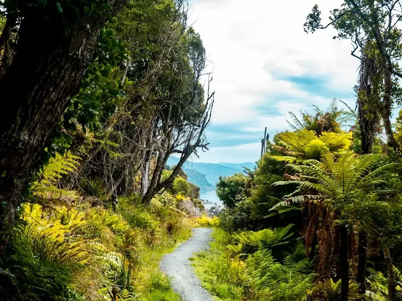
Lake Rotoroa: The tranquil beauty of Lake Rotoroa provides a serene start or end to the trek. Its clear waters and surrounding beech forests offer a peaceful environment.
Speargrass Creek Valley: The ascent through this valley offers changing scenery, from dense forest to open tussock slopes, with the sound of the creek accompanying your journey.
Boyle River Valley: The descent through the Boyle River valley showcases the transition from alpine to forested terrain. The river itself is a powerful natural feature, carving its way through the landscape.
Flora and Fauna: Keep an eye out for native New Zealand birds such as the kea (alpine parrot), robin, fantail, and bellbird. The alpine meadows may also host a variety of hardy wildflowers during the summer months.
Leave No Trace
The Waiau Pass Route traverses a pristine alpine environment that is fragile and susceptible to human impact. Adhering to Leave No Trace principles is paramount to preserving this wilderness for future generations.
Your responsibility as a walker:
- Pack it in, Pack it out: Carry out all rubbish, including food scraps, wrappers, and toilet paper. Do not bury or burn rubbish.
- Stay on the Track: Stick to the marked trail to minimise erosion and protect fragile alpine vegetation. Avoid creating shortcuts.
- Dispose of Waste Properly: Use designated toilets at huts. If camping, dig catholes at least 10 metres away from water sources, trails, and campsites. Pack out all toilet paper.
- Leave What You Find: Do not remove plants, rocks, or any natural or cultural artefacts.
- Minimise Campfire Impacts: Use a stove for cooking. If fires are permitted and necessary, use existing fire rings and keep fires small. Ensure fires are completely extinguished. (Note: Fires are generally discouraged in alpine environments).
- Respect Wildlife: Observe wildlife from a distance. Do not feed animals, as this can harm their health and alter their natural behaviours.
- Be Considerate of Others: Keep noise levels down, especially in huts and campsites, to allow others to enjoy the peace and solitude of the wilderness.
By following these principles, you help ensure that the Waiau Pass Route remains a wild and beautiful place for everyone to experience.