
Volcán Tajumulco Summit Trail - The Roof of Central America
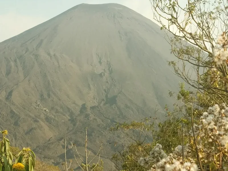
Standing at a staggering 4,220 metres above sea level, Volcán Tajumulco is the highest point in Guatemala and the entirety of Central America. Located in the department of San Marcos in the western highlands, this dormant stratovolcano offers a trekking experience that is as culturally significant as it is physically demanding. The trail to the summit is a journey through diverse ecological zones, beginning in high-altitude agricultural lands and ascending through ancient pine-oak forests before emerging onto the stark, wind-swept volcanic plateau. Unlike the more famous volcanoes near Antigua, Tajumulco provides a sense of profound isolation and raw wilderness, far removed from the primary tourist circuits. On a clear morning, the reward for the 1,400-metre ascent is a panoramic view that encompasses the volcanic arc of Guatemala, the rugged mountains of Chiapas in Mexico, and the shimmering expanse of the Pacific Ocean. This is not merely a hike; it is a pilgrimage to the highest altar of the Mayan highlands, demanding respect for the altitude and offering a perspective of the continent that few ever witness.
- Distance: 8.0 km return
- Duration: 6–8 hours (day hike) or 2 days (overnight)
- Season: November to April (dry season is essential for views and safety)
- Accommodation: Wild camping at base camp (approx. 4,000 m) or hotels in San Marcos/Xela
- Highest point: 4,220 m (Summit of Tajumulco)
- Difficulty: Challenging (primarily due to extreme altitude and steep scree)
- Trailhead: Tuichán, San Marcos (approx. 2,500 m elevation)
Overview
The Volcán Tajumulco Summit Trail is a masterclass in high-altitude trekking. While the total distance of 8 kilometres might seem modest to seasoned hikers, the vertical gain of 1,400 metres—starting at an already breathless 2,500 metres—transforms this into a formidable physical challenge. The route is characterised by its relentless upward trajectory, beginning on a dusty track used by local farmers before narrowing into a winding path through the "altiplano" forest. As you climb, the air thins perceptibly, and the lush vegetation of the lower slopes gives way to hardy bunchgrasses and stunted alpine pines. The final kilometre is a test of resolve, involving a steep scramble over volcanic scree and basalt boulders to reach the crater rim.
Geologically, Tajumulco is a complex volcano with two distinct summits. The larger, eastern peak is the true summit, featuring a well-defined crater approximately 50 metres in diameter. The smaller western peak, known as Cerro Quemado (not to be confused with the volcano of the same name near Quetzaltenango), offers an alternative perspective of the massive volcanic structure. The volcano is part of the Central America Volcanic Arc, a chain of volcanoes resulting from the subduction of the Cocos Plate beneath the Caribbean Plate. While Tajumulco has no confirmed historical eruptions, its massive presence dominates the landscape of western Guatemala, acting as a weather maker for the surrounding valleys.
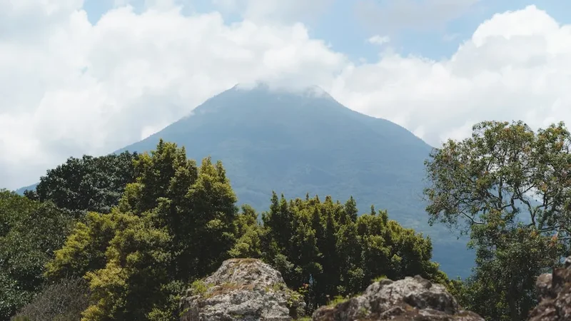
The experience of standing on the summit at dawn is often described as transcendental. As the sun rises over the eastern horizon, the triangular shadow of Tajumulco is projected for kilometres across the clouds and the landscape towards Mexico. To the south, the perfectly conical peaks of Volcán Santa María and Volcán Atitlán pierce the cloud deck, while to the west, the massive bulk of Volcán Tacaná marks the border with Mexico. This is a landscape of extremes—intense solar radiation during the day and sub-zero temperatures at night—requiring hikers to be meticulously prepared for rapid shifts in conditions. For those seeking to stand at the highest point between the Andes and the Rockies, Tajumulco is the ultimate Guatemalan objective.
History and Cultural Context
The history of Volcán Tajumulco is deeply intertwined with the Mam Maya people, who have inhabited the surrounding highlands for millennia. To the Mam, the volcano is not just a geological feature but a sacred entity, often referred to as a "heart of the earth." Even today, it is common to encounter local residents performing ceremonies or leaving offerings at various points along the trail, particularly near the summit. The name "Tajumulco" is thought to derive from the Mam language, though its exact etymology is a subject of linguistic debate, often associated with the concepts of "incense" or "smoke," hinting at a forgotten eruptive past or its role as a site for ritual fires.
During the colonial era, Tajumulco served as a vital landmark for Spanish explorers and cartographers. However, it wasn't until the late 19th and early 20th centuries that formal scientific surveys were conducted. The first recorded ascent by a European was likely during the 1800s, though local indigenous populations had undoubtedly reached the summit for ritual purposes long before. In 1956, the volcano was declared a protected area, and it remains a cornerstone of Guatemala's national park system, though management is largely handled by local communities and the municipality of San Marcos.
The region surrounding the volcano was also a significant theatre during the Guatemalan Civil War (1960–1996). The rugged terrain of the San Marcos highlands provided cover for various groups, and the scars of this conflict are still felt in the social fabric of the nearby villages. Today, the trail represents a growing opportunity for community-based tourism. By hiring local guides from Tuichán or San Marcos, hikers contribute directly to the local economy, helping to preserve the cultural heritage and natural beauty of this remote corner of the country. Understanding this context adds a layer of depth to the trek; you are not just climbing a mountain, but traversing a landscape shaped by ancient spirituality and modern resilience.
Want more background? Read extended notes on history and cultural context → Learn more
Seasonal Highlights and Weather Reality
The climbing season for Volcán Tajumulco is strictly dictated by the Guatemalan tropical cycle, which consists of a dry season (verano) and a wet season (invierno). To ensure safety and the best possible views, planning your trek within the correct window is essential.
Dry Season (November to April): This is the optimal time to climb. During these months, the skies are generally clear, especially in the early mornings. However, this is also the coldest time of year. At 4,220 metres, temperatures frequently drop below freezing (-5°C to -10°C) during the night and early morning. Frost is common at the base camp, and hikers must be prepared for biting winds on the summit ridge. The "Canicula," a brief dry spell in the middle of the rainy season (usually July or August), can sometimes provide a window for climbing, but it is less reliable.
Wet Season (May to October): Climbing during the rainy season is generally discouraged. While the mornings may start clear, heavy afternoon downpours and thunderstorms are almost guaranteed. These storms bring a significant risk of lightning strikes on the exposed upper slopes and summit. Furthermore, the trail becomes extremely muddy and slippery, and the summit is often shrouded in thick "neblina" (fog), completely obscuring the views. The risk of hypothermia increases significantly when hikers get wet in the high-altitude winds.
Weather Reality: Regardless of the season, Tajumulco creates its own microclimate. It is not uncommon to experience four seasons in a single day. Intense tropical sun can lead to rapid sunburn and dehydration in the morning, while sudden cloud cover can drop the temperature by 10 degrees in minutes. High winds are a constant factor on the crater rim, often reaching speeds that make standing difficult. Always check the forecast from INSIVUMEH (Guatemala's national weather service) before departing, but be prepared for the mountain to ignore the forecast entirely.
Recommended Itinerary
Volcán Tajumulco Day Hike Itinerary
Early Morning: The Ascent from Tuichán
- Time: 04:00 – 06:00
- Distance: 2.5 km
- Elevation Gain: 500 m
- Start at the trailhead in the village of Tuichán (approx. 2,500 m).
- The trail begins as a wide, dusty track through potato and corn fields.
- Steady incline through the lower forest zone, consisting of pine and cypress.
- Waypoints: Pass the local registration point and the last of the agricultural terraces.
- Focus on a slow, rhythmic pace to allow the body to adjust to the thinning air.
Mid-Morning: The High Altiplano and Base Camp
- Time: 06:00 – 08:30
- Distance: 1.0 km
- Elevation Gain: 600 m
- The forest thins out, replaced by high-altitude bunchgrass (pajón).
- The trail becomes steeper and more rugged, with rocky sections.
- Arrive at the "Base Camp" area (approx. 4,000 m), a flat plateau used by overnight trekkers.
- This is the final place with significant wind protection before the summit push.
- Take a mandatory 20-minute break here to hydrate and consume high-energy snacks.
Late Morning: The Summit Push
- Time: 08:30 – 10:00
- Distance: 0.5 km
- Elevation Gain: 220 m
- The most challenging section: a steep scramble over loose volcanic scree and large basalt blocks.
- The trail skirts the southern side of the cone before ascending the final ridge.
- Reach the crater rim and follow it to the highest point on the eastern side.
- Summit (4,220 m): Enjoy 360-degree views of Guatemala and Mexico.
- Explore the crater floor if wind conditions allow.
Midday: The Descent to Tuichán
- Time: 10:30 – 13:30
- Distance: 4.0 km
- Elevation Loss: 1,400 m
- Retrace your steps down the scree slope (trekking poles are highly recommended here).
- The descent is much faster but puts significant strain on the knees.
- As you descend, the air becomes noticeably thicker and warmer.
- Arrive back at the Tuichán trailhead for transport back to San Marcos or Xela.
- Total moving time: Approximately 6–8 hours depending on fitness and acclimatisation.
Important Notes:
- This itinerary assumes a day hike starting in the pre-dawn hours to catch the best weather.
- If doing an overnight trek, the ascent is split over two days, with a night spent at base camp.
- Altitude sickness is a real risk; if you feel severe headaches or nausea, descend immediately.
- There are no water sources on the trail; you must carry all required fluids.
- The trail is generally well-marked, but fog can make navigation difficult on the upper plateau.
Planning and Bookings
Book Your Trip
Everything you need to plan your journey
Accommodation
Find places to stay near San Marcos
Flights
Search flights to San Marcos
Essential Preparation
The primary challenge of Volcán Tajumulco is the altitude. Proper acclimatisation is not optional; it is a safety requirement. It is strongly recommended to spend at least 2–3 days in Quetzaltenango (Xela) at 2,330 metres or San Marcos at 2,400 metres before attempting the summit. Many hikers find that a "warm-up" hike, such as Volcán Santa María or the trek to Laguna Chicabal, helps significantly with performance on Tajumulco.
Logistically, the most common base for the hike is the city of San Marcos. From San Marcos, you can hire a private 4x4 shuttle or take a local "chicken bus" heading towards San José Ojetenam, asking to be dropped at the trailhead in Tuichán. The journey takes approximately one hour. If you are coming from Xela, allow 2.5 to 3 hours for transport. Most organised tours depart from Xela around 2:00 AM to reach the trailhead for a sunrise start.
Trail Accommodation
This is primarily a day hike, and there are no formal huts or lodges on the mountain itself. However, for those wishing to experience the summit at sunrise without a 2:00 AM start, camping is the only option.
Camping Facilities:
- Base Camp (4,000 m): A flat, rocky area located about 200 metres below the summit. There are no facilities here—no toilets, no water, and no shelters.
- Shelter: There is a very basic, often dilapidated stone shelter near the base camp, but it is frequently filled with trash and should not be relied upon for accommodation.
- Cost: There is currently no fee for camping, though you should register your presence at the trailhead.
What is NOT Provided:
- There is absolutely no water on the mountain. You must carry 3–4 litres per person for an overnight trip.
- No food or cooking fuel is available.
- No waste disposal facilities; you must pack out all rubbish.
Base Town Accommodation: Most hikers stay in San Marcos or Xela. San Marcos offers several mid-range hotels and basic "pensiones." Xela has a much wider range of hostels, boutique hotels, and international-standard accommodation, making it the preferred choice for most international travellers.
Required Gear
- Trekking Boots: Sturdy, waterproof boots with deep lugs are essential for the loose scree and rocky sections.
- Layered Clothing: A moisture-wicking base layer, a warm fleece or down mid-layer, and a high-quality windproof/waterproof outer shell.
- Headlamp: Essential for pre-dawn starts, with spare batteries. The trail is uneven and requires clear visibility.
- Trekking Poles: Highly recommended to save your knees during the 1,400-metre descent and provide stability on the scree.
- Backpack: A 20–30L pack for day hikers, or 50–60L for those camping. Ensure it has a rain cover.
- Sun Protection: High-altitude UV is intense. Bring SPF 50+ sunscreen, lip balm with SPF, and polarised sunglasses.
- Warm Accessories: A beanie (wool hat) and insulated gloves are mandatory for the summit, where wind chill is significant.
What to Bring
- Water: Minimum 3 litres for a day hike; 5 litres for an overnight. There are no refill points.
- Food: High-calorie snacks (nuts, chocolate, energy bars) and a substantial lunch. Complex carbohydrates are best for altitude.
- Electrolytes: Rehydration salts or electrolyte tablets to mix with your water.
- First Aid Kit: Include blister plasters, ibuprofen (for altitude headaches), and any personal medications.
- Emergency Blanket: A lightweight "space blanket" for unexpected delays or weather shifts.
- Identification: A copy of your passport and some local currency (Quetzales) for transport and small purchases in Tuichán.
- Toilet Paper and Trowel: Since there are no facilities, you must follow LNT principles for human waste.
Permits
Currently, there is no formal national park permit system or advance booking required to climb Volcán Tajumulco. This makes it one of the most accessible high-altitude peaks in the world, but it also means there is less formal oversight of trail conditions and safety.
Registration Process:
- Upon arrival at the trailhead in Tuichán, there is often a small community-run registration post. It is highly recommended to sign in here with your name, nationality, and expected return time.
- A small voluntary contribution (usually 10–20 Quetzales) is sometimes requested by the local community for trail maintenance. While not a legal requirement, paying this supports the local economy and ensures the trail remains open.
- If you are climbing with an organised tour from Xela or San Marcos, your guide will handle all local registrations and fees.
Guide Requirements:
- While not legally mandatory, hiring a local guide is strongly recommended for those unfamiliar with high-altitude trekking or the specific geography of Tajumulco.
- The trail can be obscured by fog, and having someone who knows the terrain and can monitor for signs of altitude sickness is a significant safety advantage.
- Guides can be hired in San Marcos or through reputable agencies in Xela. Ensure your guide is experienced and carries a first aid kit and communication device.
Group Size and Access: There are currently no limits on group sizes or daily visitor numbers. However, to preserve the sense of wilderness and reduce environmental impact, it is best to travel in small groups. Access is open year-round, though as noted, the dry season is the only sensible time for an ascent.
Other Activities in the Area
The western highlands of Guatemala offer a wealth of cultural and natural attractions that complement a Tajumulco trek:
- Fuentes Georginas: Located near Almolonga, these natural hot springs are the perfect way to soothe sore muscles after the descent. The pools are fed by volcanic activity and surrounded by lush cloud forest.
- Quetzaltenango (Xela) City Tour: Explore Guatemala's second-largest city, known for its neoclassical architecture, vibrant central park, and excellent Spanish language schools.
- Laguna Chicabal: A sacred crater lake located within the Chicabal Volcano. It is a significant site for Mayan ceremonies and offers a beautiful, less strenuous hike through the cloud forest.
- San Francisco El Alto Market: If your hike coincides with a Friday, visit one of the largest and most authentic highland markets in the country, famous for its textiles and livestock trade.
- Volcán Santa María: For those who haven't had enough of volcanoes, the ascent of Santa María offers incredible views of the active Santiaguito dome erupting below.
- Lake Atitlán: A few hours' drive to the east, this world-famous lake is surrounded by three more volcanoes and numerous indigenous villages, offering a perfect place to relax post-hike.
Safety and Conditions
Altitude Sickness (AMS): This is the single greatest risk on Tajumulco. Starting at 2,500 m and reaching 4,220 m in a few hours is a massive physiological shock. Symptoms of Acute Mountain Sickness include severe headache, nausea, dizziness, and extreme fatigue. The only cure for AMS is descent. Do not "push through" severe symptoms; if they persist or worsen, descend immediately to Tuichán. Ensure you are well-hydrated and have spent several days at altitude before the climb.
Hypothermia and Exposure: Even if it is 25°C in San Marcos, it can be -5°C on the summit with wind chill. Wet clothing from sweat or rain significantly increases the risk of hypothermia. Always carry a dry change of base layers and a high-quality windproof shell. Never attempt the summit push if a thunderstorm is approaching; the exposed ridge is a high-risk area for lightning strikes.
Navigation and Visibility: The upper plateau of Tajumulco is broad and can be extremely disorienting in thick fog (neblina). It is easy to lose the trail on the rocky sections. If visibility drops to less than 20 metres, stay put or retrace your steps carefully using a GPS or compass. Do not attempt to "shortcut" the descent through the scree fields, as this can lead to falls or getting lost in the drainage gullies.
Personal Safety: While Tajumulco is generally safe, there have been isolated reports of robberies on the lower sections of the trail in years past. It is always safer to hike in a group or with a local guide. Avoid carrying excessive cash or expensive jewellery. Check with local trekking agencies in Xela for the most recent security updates before heading out.
Communication: Mobile signal is surprisingly good on the summit and parts of the ridge, but non-existent in the valleys and lower forest. Do not rely on your phone as your only safety device. Inform someone of your itinerary and expected return time before you start.
Side Trips and Points of Interest
The Crater Floor: Once you reach the summit rim, it is possible to descend into the actual crater of Tajumulco. The floor is relatively flat and about 50 metres across. It is a surreal, silent place, shielded from the wind, where you can see the volcanic architecture from the inside. Look for small vents and unique mineral deposits on the crater walls.
Cerro Quemado (The Western Peak): Tajumulco is a twin-peaked volcano. While the eastern peak is the highest, the western peak (Cerro Quemado) is worth the extra 45-minute detour for those with remaining energy. It offers a spectacular profile view of the main summit cone and is often much quieter than the true summit.
The "Shadow of the Volcano": If you reach the summit at sunrise during the dry season, look towards the west (towards Mexico). You will see the perfect triangular shadow of Tajumulco projected onto the atmosphere or the clouds below. It is a fleeting but magnificent optical phenomenon that only occurs in the first 30 minutes of daylight.
Mayan Altars: Throughout the climb, and especially on the summit, you will see stone circles and blackened areas where incense (copal) has been burned. These are active ritual sites. Please treat them with the utmost respect—do not touch the offerings, do not move the stones, and if a ceremony is in progress, keep a respectful distance and do not take photographs without permission.
Leave No Trace
Volcán Tajumulco is a fragile high-altitude ecosystem that faces significant pressure from unregulated tourism. Because there is no formal waste management on the mountain, every hiker must take personal responsibility for their environmental footprint. The "Pack it in, Pack it out" rule is absolute here.
Your responsibility as a walker:
- Carry out all trash, including "biodegradable" items like orange peels or banana skins, which decompose very slowly in the cold, dry air of the summit.
- Stay on the established trail. The high-altitude bunchgrasses and alpine plants are extremely sensitive to trampling and take years to recover.
- Dispose of human waste properly. Since there are no toilets, use a trowel to bury waste at least 15 cm deep and at least 60 metres away from the trail and base camp areas. Pack out your used toilet paper in a sealed plastic bag.
- Never light fires. Wood is scarce at this altitude, and the risk of a wildfire in the dry bunchgrass is extremely high. Use a lightweight camping stove if you need to cook.
- Respect the silence. The high altiplano is a place of solitude; avoid loud music or shouting, which disturbs both wildlife and other hikers.
- Do not take "souvenirs." Leave rocks, plants, and cultural artefacts exactly where you found them for others to enjoy.
By following these principles, you help ensure that Tajumulco remains a pristine and sacred destination for future generations of hikers and the local Mam community.