Vindhellavegen Stave Route - A Masterpiece of Historic Engineering
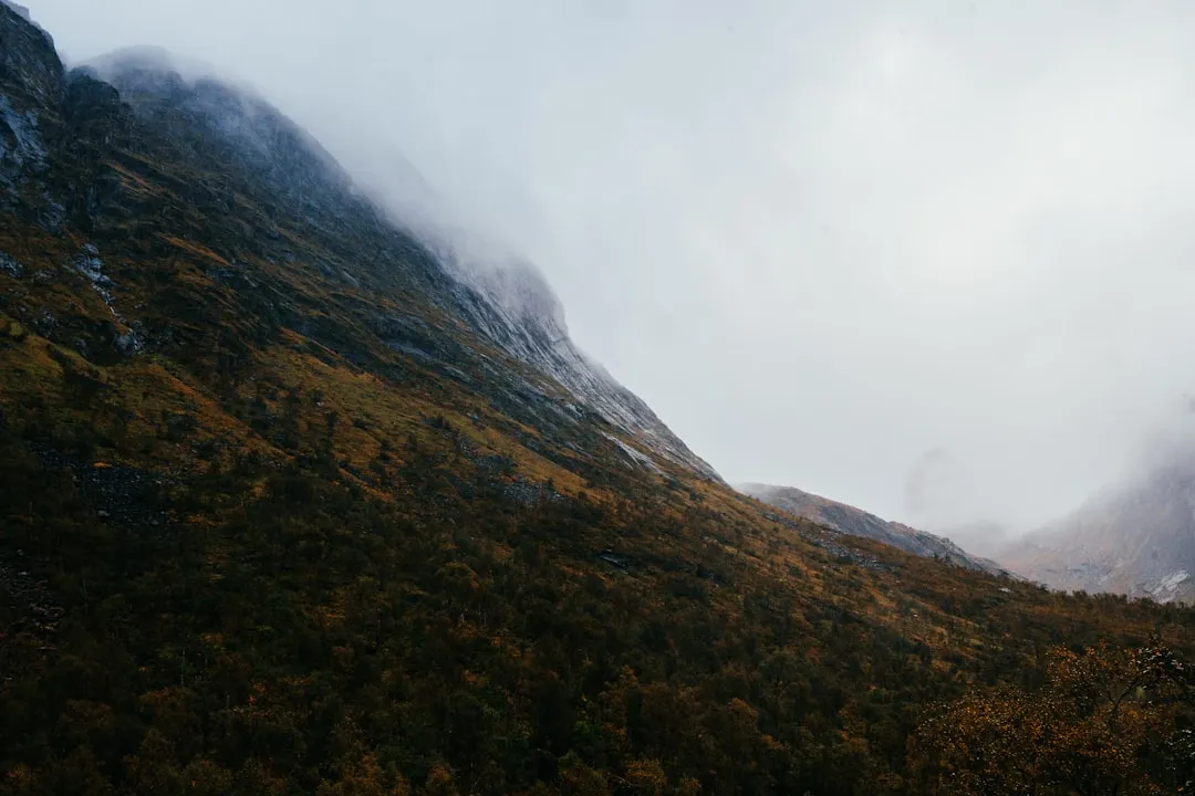
The Vindhellavegen Stave Route is not merely a hiking trail; it is a journey through the evolution of Norwegian transport history, carved into the steep, rugged terrain of the Lærdal valley. Located in the heart of Vestland county, this 4.5-kilometre loop represents the most spectacular section of the Kongevegen (The King’s Road) over Filefjell. It is a place where 18th-century ambition meets 19th-century engineering brilliance, all set against the backdrop of the iconic Borgund Stave Church—the best-preserved stave church in Norway. The trail is world-renowned for its dramatic hairpin bends, supported by massive dry-stone walls that rise up to 12 metres from the valley floor, creating a visual rhythm that feels more like a cathedral of stone than a mountain pass. For the modern walker, Vindhellavegen offers a moderate but deeply rewarding experience, blending cultural heritage with the raw, vertical beauty of the Norwegian fjords and mountains.
- Distance: 4.5 km loop
- Duration: 2–3 hours
- Season: May to October (snow-free conditions recommended)
- Elevation Gain: 300 m
- Difficulty: Moderate (steep gradients but well-maintained surface)
- Location: Borgund, Lærdal, Norway
- Key Landmark: Borgund Stave Church (12th century)
Overview
The Vindhellavegen section of the King’s Road is a testament to the sheer will of Norwegian road builders who sought to conquer the formidable "Vindhella" (Windy Hill) pass. The route is famous for its four sharp hairpin bends, constructed in the 1840s to replace an even steeper 1790s road that had become impassable for the increasingly heavy horse-drawn traffic of the era. As you walk the trail, you are treading on a surface that was once the primary artery between Eastern and Western Norway, a vital link for post, trade, and royal travel. The engineering is staggering: the road is built upon high stone embankments, meticulously crafted without mortar, which have stood the test of time and the harsh Scandinavian climate for nearly two centuries.
The landscape here is quintessential Norway. The trail begins in the lush valley floor near the Borgund Stave Church, where the air is often filled with the scent of pine and ancient wood tar. As you ascend, the valley narrows, and the sound of the Lærdalselvi river—one of Norway’s most famous salmon rivers—echoes off the granite cliffs. The "Vindhella" name is well-earned; the pass acts as a natural funnel for the winds blowing from the high mountains down toward the Sognefjord, creating a microclimate that can feel significantly cooler than the valley below. The contrast between the dark, dragon-crested silhouette of the stave church and the pale, geometric precision of the stone road creates a photographic and emotional experience that is unique in the world of hiking.
While the distance is short, the experience is dense. Every metre of the trail tells a story of labour, logistics, and the transition from a medieval society to a modern nation. The path is wide and surfaced with gravel and stone, making it accessible for most walkers with a reasonable level of fitness. However, the gradients are significant, reaching up to 1:4 in some sections of the older road, which provides a physical challenge that reminds the walker of the hardships faced by the travellers of old. Whether you are a history enthusiast, an architecture lover, or a nature seeker, Vindhellavegen delivers a concentrated dose of Norwegian heritage in a manageable afternoon walk.
History and Cultural Context
The history of Vindhellavegen is inextricably linked to the Kongevegen over Filefjell, the first road suitable for wheeled vehicles between Oslo (then Christiania) and Bergen. Before the road was built, travellers had to navigate treacherous mountain paths and steep scree slopes. In the late 18th century, the Danish-Norwegian authorities recognised the need for a more reliable postal and military route. The first "modern" road through Vindhella was completed in 1793, designed by C.J. Hammer. This road followed the natural contours of the terrain but was notoriously steep, with gradients that exhausted horses and required travellers to disembark and push their carriages.
By the 1840s, the 1793 road was deemed insufficient for the growing demands of Norwegian commerce. Captain Henrik Christian Finne of the Road Engineers was tasked with redesigning the pass. His solution was revolutionary: instead of fighting the steepness with sheer force, he used the principles of modern road engineering to create the four famous hairpin bends. By building massive stone walls to support the roadbed, he was able to reduce the gradient, though it remained one of the steepest sections of the King’s Road. The craftsmanship of the dry-stone walling is particularly notable; the stones were sourced locally and fitted together with such precision that they have required minimal maintenance over the last 180 years.
At the base of the trail lies the Borgund Stave Church, built around 1180. This architectural marvel serves as the spiritual and historical anchor of the route. Stave churches are unique to Northern Europe, and Borgund is the most authentic example remaining, having survived without significant structural changes for over 800 years. The church features intricate carvings of dragons and crosses, representing the transition from Norse paganism to Christianity. The proximity of the church to the road is no coincidence; the church was the centre of the community and a landmark for travellers for centuries. Walking Vindhellavegen is, therefore, a journey through three distinct eras: the medieval period of the stave church, the Enlightenment era of the 1790s road, and the industrial-age engineering of the 1840s.
Want more background? Read extended notes on history and cultural context → Learn more
Seasonal Highlights and Weather Reality
The Vindhellavegen Stave Route is best experienced during the warmer months, typically from May to October. During this window, the trail is generally free of snow, and the surrounding vegetation is at its most vibrant. However, the Norwegian weather is famously unpredictable, and walkers should be prepared for rapid changes in conditions even in the height of summer.
Spring (May to June): This is a spectacular time to visit as the snow melts from the higher peaks, feeding the waterfalls that cascade down the valley walls. The Lærdalselvi river is at its most powerful, and the wildflowers begin to bloom along the road embankments. Be aware that late-season snow patches can sometimes linger in the shaded sections of the pass until late May.
Summer (July to August): This is the peak season for tourism. The weather is generally mild, with temperatures ranging from 15°C to 25°C. The long daylight hours of the Norwegian summer allow for late-evening walks when the low sun casts long, dramatic shadows across the stone walls of the hairpins. This is also the best time to visit the Borgund Stave Church visitor centre, which is fully operational during these months.
Autumn (September to October): As the birch trees turn golden and the mountain air becomes crisp, Vindhellavegen takes on a more somber, majestic character. The crowds thin out, providing a more solitary experience. However, the days shorten rapidly, and the stone surface of the road can become slippery when wet or covered in fallen leaves. Early frosts can occur in October, making the steep sections hazardous.
Winter (November to April): The trail is not maintained during the winter months. While it is possible to walk with snowshoes or micro-spikes, the steep gradients and potential for ice make it a challenging and potentially dangerous undertaking. The road is often covered in deep snow, obscuring the historic features. Most visitors avoid the trail during this time, as the Borgund Stave Church is also closed to interior tours during the coldest months.
Recommended Itinerary
Vindhellavegen Loop Itinerary
Phase 1: The Departure from Borgund
- Start: Borgund Stave Church car park
- Distance: 0.5 km
- Time: 15–20 minutes
- Begin by exploring the exterior of the Borgund Stave Church and the nearby "New" Borgund Church (built in 1868)
- Follow the signs for "Kongevegen" and "Vindhellavegen" heading east
- The trail starts as a gentle gravel path through a small wooded area
- Pass the visitor centre where you can learn about the road's construction before starting the ascent
Phase 2: The Ascent of Vindhella
- Distance: 1.5 km
- Elevation gain: 200 m
- Time: 45–60 minutes
- The gradient increases as you enter the narrowest part of the pass
- You will first encounter the 1793 road, which is steeper and follows the valley floor more closely
- The path then transitions into the 1840s road, where the massive stone embankments become visible
- This is the most physically demanding part of the walk, but the surface is stable and wide
- Take time to look back toward the valley for views of the church framed by the mountains
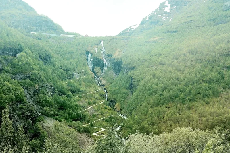
Phase 3: The Hairpin Bends and Summit
- Distance: 1 km
- Time: 30 minutes
- Reach the famous four hairpin bends where the road zig-zags up the cliff face
- The stone walls here are a marvel of engineering—some are over 10 metres high
- At the top of the pass (the "summit"), there is a flat area perfect for a rest and a snack
- The wind is often strongest here, providing a cooling effect after the climb
- Look for the historic markers and information boards explaining the masonry techniques used
Phase 4: The Descent via Sverrestigen
- Distance: 1.5 km
- Time: 45 minutes
- To complete the loop, follow the signs for "Sverrestigen" (King Sverre’s Path)
- This is an even older route, dating back to the medieval period, used by King Sverre Sigurdsson in 1177
- The path is narrower and more "natural" than the engineered King’s Road
- It winds through the forest and offers different perspectives of the valley and the stave church
- The descent brings you back to the starting point at the Borgund Stave Church car park
Important Notes:
- The trail is well-marked with red "K" signs (for Kongevegen)
- The loop can be walked in either direction, but ascending the hairpins is generally considered more scenic
- Allow extra time (at least 1 hour) to tour the Stave Church and the museum
- The stone surface can be very slippery during or after rain
- There are no toilets or water points on the trail itself; use the facilities at the visitor centre
Planning and Bookings
Book Your Trip
Everything you need to plan your journey
Accommodation
Find places to stay near Lærdalsøyri
Flights
Search flights to Lærdalsøyri
Essential Preparation
Vindhellavegen is a day hike that requires no advanced bookings or permits, making it one of the more accessible historic walks in Norway. However, its location in the rural Lærdal valley means that transport and timing are key. The nearest major town is Lærdalsøyri, approximately 30 kilometres away. Most visitors base themselves in Lærdalsøyri, Sogndal, or Flåm.
Fitness requirements are moderate. While the trail is short, the 300-metre elevation gain occurs over a relatively short distance, meaning the gradients are steep. Walkers should be comfortable with sustained uphill walking on uneven surfaces. If you plan to visit the Borgund Stave Church (highly recommended), check the seasonal opening hours in advance, as they vary significantly between May and September.
Logistically, the easiest way to reach the trailhead is by car. There is ample parking at the Borgund Stave Church visitor centre. For those using public transport, the "Øst-Vestekspressen" bus service runs between Lillehammer and Bergen, stopping at Borgund. However, services are infrequent, so careful coordination with the bus timetable is essential.
Trail Accommodation
This is a day hike requiring no overnight accommodation on the trail itself. Camping is not permitted in the immediate vicinity of the Borgund Stave Church or on the historic road structures to protect the heritage site.
Nearby Options:
- Lærdalsøyri: Offers a range of accommodation from historic hotels (like the Lindstrøm Hotel) to modern campsites and cabins. It is a 25-minute drive from the trailhead.
- Borgund Hyttesenter: Located very close to the trailhead, offering simple cabins and camping spots for those who want to stay within walking distance of the church.
- Husum Hotel: A historic coaching inn located a few kilometres down the road, which has served travellers on the King’s Road for generations.
- Wild Camping: Under Norway’s "Allemannsretten" (Right to Roam), you can camp in the mountains away from cultivated land and at least 150 metres from inhabited houses. However, you must ensure you are not within the protected heritage zone of the King’s Road.
Required Gear
- Footwear: Sturdy walking shoes or light hiking boots with good grip. The historic stone road can be uneven and slippery, especially on the descent.
- Clothing: Layered clothing is essential. Even on a warm day, the "Vindhella" pass can be windy and cool. A windproof jacket is highly recommended.
- Rain Gear: A lightweight waterproof jacket. Lærdal is in a rain shadow and is drier than Bergen, but sudden mountain showers are common.
- Sun Protection: Hat, sunglasses, and sunscreen. The trail is quite exposed in the higher sections with little shade.
- Navigation: The trail is very well-marked, but a basic map or a downloaded offline map (like UT.no or Google Maps) is useful for peace of mind.
What to Bring
- Water: Bring at least 1 litre of water per person. There are no potable water sources on the trail, though you can refill at the visitor centre.
- Snacks: High-energy snacks like nuts, fruit, or chocolate for the summit of the pass.
- Camera/Phone: The hairpins and the stave church are among the most photographed spots in Norway. Ensure your devices are fully charged.
- Small First Aid Kit: Plasters (band-aids) for blisters, antiseptic wipes, and any personal medication.
- Cash/Card: For the entrance fee to the Stave Church and the visitor centre café. Most places in Norway are card-only, but a small amount of cash can be useful.
Permits
No permits are required to walk the Vindhellavegen Stave Route or any part of the Kongevegen over Filefjell. Norway’s "Allemannsretten" (Right to Roam) ensures that everyone has the right to access the countryside, provided they do so respectfully and without damaging the environment or heritage structures.
Access and Fees:
- Trail Access: Free of charge, 24 hours a day.
- Parking: There is a fee for parking at the Borgund Stave Church visitor centre during the peak season. This fee helps maintain the facilities and the historic site.
- Stave Church Entry: To enter the interior of the Borgund Stave Church and the museum, you must purchase a ticket. As of 2024, the cost is approximately 110 NOK for adults, with discounts for children, students, and seniors.
- Guided Tours: During the summer, guided tours of the church and parts of the King’s Road are available for an additional fee. These can be booked at the visitor centre.
Regulations:
- Drones: The use of drones is strictly regulated around the Borgund Stave Church and the historic road. Check local signage, as flight bans are often in place to protect the integrity of the site and the experience of other visitors.
- Cycling: While parts of the King’s Road are popular for cycling, the Vindhellavegen section is very steep and has a delicate historic surface. Cyclists are encouraged to walk their bikes or use the alternative route (the E16 tunnel bypass) if they are not confident on steep, gravelly descents.
- Dogs: Dogs are welcome but must be kept on a lead at all times, especially near the church and in areas where livestock (sheep) may be grazing.
Other Activities in the Area
The Lærdal region is a hub for cultural and outdoor activities. Consider these options to round out your visit:
- The Norwegian Wild Salmon Centre: Located in Lærdalsøyri, this museum offers fascinating insights into the life cycle of the Atlantic salmon and the history of salmon fishing in the Lærdalselvi river.
- Old Lærdalsøyri: Take a stroll through this remarkably well-preserved village featuring over 160 wooden buildings dating from the 18th and 19th centuries. It is one of the few such architectural ensembles left in Norway.
- The King’s Road (Full Route): If you have more time, you can walk other sections of the 100-kilometre Kongevegen. The section from Øye to Tyinkrysset offers high-mountain scenery, while the Galdane section features dramatic cliffs and waterfalls.
- Stegastein Viewpoint: A 45-minute drive away, this architectural platform juts out 30 metres from the mountainside, 650 metres above the Aurlandsfjord, offering one of Norway’s most famous views.
- Flåm Railway: Often described as one of the most beautiful train journeys in the world, the Flåmsbana is a short drive or bus ride from Lærdal.
- Fjord Cruises: From nearby Flåm or Gudvangen, you can take a cruise on the Nærøyfjord, a UNESCO World Heritage site known for its narrow passages and towering peaks.
Safety and Conditions
Pre-Departure Checks:
- Check the local weather forecast on Yr.no. Pay particular attention to wind speeds, as the Vindhella pass can be significantly windier than the valley floor.
- Ensure you have adequate footwear. The historic road surface consists of loose gravel and smooth stones which can be treacherous when wet.
- Inform someone of your plans, although the trail is popular and you are unlikely to be alone for long.
Terrain Hazards: The primary hazard on Vindhellavegen is the steepness of the trail. The 1840s road was built for horse-drawn carriages, not modern vehicles, and the gradients are much steeper than a modern road. On the descent, the combination of gravity and loose surface can lead to slips and falls. The Sverrestigen path is narrower and has more roots and rocks, requiring careful foot placement. There are also steep drops off the side of the road embankments; while the road is wide, children should be supervised closely.
Weather Reality: In the mountains of Western Norway, weather can change in minutes. A sunny morning can quickly turn into a cold, rainy afternoon. Hypothermia is a risk even in summer if you get wet and the wind picks up at the top of the pass. Always carry a windproof or waterproof layer.
Livestock: You may encounter sheep grazing along the trail. They are generally harmless but can be startled by dogs or loud noises. Give them space and do not attempt to feed them.
Emergency Services: In case of an emergency, dial 112 for police, 113 for ambulance, or 110 for fire. Mobile phone coverage is generally good along the entire loop, but there may be small "dead zones" in the deepest parts of the pass.
Side Trips and Points of Interest
Sverrestigen (King Sverre’s Path): This is the "wilder" alternative to the engineered King’s Road. In 1177, King Sverre and his Birkebeiner rebels used this path to bypass farmers who were waiting to ambush them in the valley. Walking this path gives you a sense of how difficult travel was before the 18th-century road-building projects. It offers excellent views of the Vindhellavegen hairpins from across the gorge.
The Bell Tower: Near the Borgund Stave Church stands a unique, free-standing wooden bell tower. It is the only one of its kind from the Middle Ages still standing in Norway. The bells were used to call the faithful to prayer and to signal emergencies in the valley.
Galdane: A few kilometres west of Vindhellavegen lies the Galdane section of the King’s Road. This path is carved into a vertical cliff face above the Lærdalselvi river. It is a more challenging walk but offers spectacular views of the river and the "Sokni" waterfall. It can be combined with Vindhellavegen for a longer day of hiking.
Rimskjold: A viewpoint located slightly off the main King’s Road path that offers a panoramic view of the Borgund valley. It is a great spot for photography, especially in the early morning when the mist often clings to the valley floor around the stave church.
The Old Post Route: Look for the small stone markers along the road. These were used to guide the postal riders who travelled this route year-round, often in horrific conditions, to ensure the mail moved between Norway’s two largest cities.
Leave No Trace
The Vindhellavegen Stave Route is a protected cultural heritage site. The stone walls and the road surface are historical monuments, and their preservation depends on the respect of every visitor. The "Leave No Trace" principles are essential here to ensure that this 200-year-old masterpiece remains intact for another two centuries.
Your responsibility as a walker:
- Protect the Masonry: Do not climb on the dry-stone walls or remove any stones. The walls are held together by gravity and precision; removing even a small stone can compromise the structural integrity of the embankment.
- Stay on the Path: Avoid taking shortcuts between the hairpin bends. This causes soil erosion and damages the historic roadbed.
- Pack Out All Trash: There are bins at the visitor centre, but none on the trail. Ensure you take all wrappers, fruit peels, and tissues back with you.
- Respect the Church Grounds: The area around the stave church is a site of religious and historical significance. Maintain a quiet and respectful demeanour.
- No Fires: Lighting fires on or near the historic road is strictly prohibited. The dry wood of the nearby stave church and the surrounding forest makes fire a significant risk.
- Human Waste: Use the toilets at the visitor centre before starting your walk. If you are caught short, ensure you are at least 50 metres from the trail and any water sources, and bury all waste deeply.
By following these guidelines, you help preserve one of Europe’s most significant transport heritage sites. Walk with care and leave only footprints.