Via Augustana - A Roman Odyssey Through the Tyrolean Alps
The Via Augustana is a spectacular 130-kilometre multi-day trekking route that follows the historic corridor of the Via Claudia Augusta, the ancient Roman road that once connected the Adriatic port of Altinum and the river Po with the Danube. This specific Austrian section, centred around the dramatic Wipptal valley and the surrounding Stubai and Tuxer Alps, offers walkers a profound journey through time and terrain. Starting near the historic town of Matrei am Brenner, just south of Innsbruck, the trail weaves through high alpine meadows, dense larch forests, and traditional Tyrolean villages, eventually crossing the legendary Brenner Pass. With a total elevation gain of approximately 3,500 metres, the route is classified as moderate, making it accessible to fit hikers who wish to combine physical challenge with deep cultural immersion. Unlike many high-altitude alpine circuits, the Via Augustana stays primarily on well-maintained paths and ancient trade routes, providing a unique perspective on how humanity has traversed these formidable mountains for over two millennia.
- Distance: 130.0 km total
- Duration: 7–9 days
- Elevation Gain: 3,500 m
- Difficulty: Moderate
- Best Time: June to September
- Closest City: Innsbruck, Austria
- Trailhead: Matrei am Brenner
- Accommodation: Mountain huts (Alms), traditional guesthouses, and village hotels
Overview
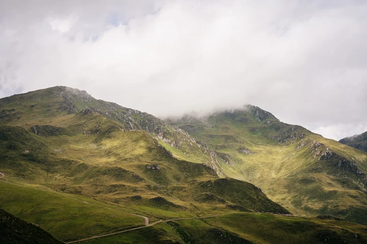
The Via Augustana is more than just a hiking trail; it is a living museum of European history. The route traverses the heart of the Tyrol region, a landscape defined by its jagged limestone peaks and deep, emerald-green valleys. For the modern walker, the trail provides a masterclass in alpine geography. The journey begins in the lower reaches of the Wipptal, where the Sill River has carved a path through the mountains, creating a natural transit corridor that has been used since the Bronze Age. As you progress southward, the scenery shifts from the pastoral charm of hay meadows and flower-filled balconies to the rugged, windswept beauty of the high passes.
The difficulty is rated as moderate, primarily because the trail avoids technical climbing or extreme exposure. However, the cumulative distance and daily elevation changes require a solid level of fitness. Walkers can expect to cover between 15 and 20 kilometres per day, with climbs ranging from 400 to 800 metres. The path itself is a mixture of gravel forest roads, narrow mountain tracks, and occasional paved sections through historic village centres. This variety keeps the walking engaging, as every turn reveals a new vista—perhaps a hidden chapel perched on a cliffside, a thundering waterfall fed by glacial melt, or a herd of Haflinger horses grazing in a high-altitude basin.
One of the defining characteristics of the Via Augustana is its accessibility to local culture. Unlike wilderness treks that isolate the hiker from civilisation, this route encourages interaction with the Tyrolean way of life. You will pass through "Bergsteigerdörfer" (mountaineering villages) like Trins and Gries am Brenner, where the pace of life remains dictated by the seasons and the mountains. The hospitality found in the mountain huts (Alms) is legendary, offering weary travellers a chance to sample local specialities like Speckknödel (bacon dumplings) and Kaiserschmarrn (shredded pancakes) while overlooking the peaks they have just conquered. This blend of natural splendour and cultural richness makes the Via Augustana one of the most rewarding long-distance walks in the Eastern Alps.
History and Cultural Context
The history of the Via Augustana is inextricably linked to the Roman Empire's expansion into Northern Europe. In 15 BC, Drusus and Tiberius, the stepsons of Emperor Augustus, led a military campaign to conquer the Alpine tribes and secure the mountain passes. To consolidate their control and facilitate trade, they began the construction of the Via Claudia Augusta. Completed under Emperor Claudius in 47 AD, it became the first proper road across the Alps, wide enough for wagons and maintained by a network of stations and fortifications. The section you walk today follows the "Brenner Route," which served as the primary artery for Roman legions, merchants, and later, Holy Roman Emperors travelling to Rome for their coronations.
Throughout the Middle Ages, the route remained the most important trade link between Germany and Italy. The "Brenner" was the lowest pass in the main chain of the Alps, making it the path of least resistance for the transport of salt, wine, and silk. The wealth generated by this trade is still visible in the architecture of the towns along the trail. Matrei am Brenner, for instance, was a vital staging post where horses were changed and tolls were collected. The town's historic inns, some with foundations dating back centuries, have hosted everyone from Goethe to Mozart. As you walk, you will encounter Roman milestones, medieval ruins, and Baroque churches, each layer of history stacked upon the last like the geological strata of the mountains themselves.
The cultural significance of the trail also extends to the local farming traditions. The "Alm" system—the seasonal movement of livestock to high-altitude pastures—has shaped the landscape for over a thousand years. The open meadows you traverse are not natural clearings but carefully managed landscapes that support a unique ecosystem of alpine flora. The stone walls, hay barns, and shrines (Marterl) found along the path are testaments to the resilience and faith of the mountain people. Understanding this history transforms the walk from a physical exercise into a pilgrimage through the soul of the Tyrol.
Want more background? Read extended notes on history and cultural context → Learn more
Seasonal Highlights and Weather Reality
The window for walking the Via Augustana is dictated by the alpine snowpack. While the valleys may be green by May, the higher passes and shaded forest tracks often hold snow well into June. Consequently, the prime season is from mid-June to late September. During this period, the mountain huts are fully operational, and the trail is generally clear of significant snow hazards.
Early Summer (June to July): This is arguably the most beautiful time to visit. The alpine meadows are in full bloom, with gentians, primroses, and the iconic Almenrausch (alpine rose) creating a vibrant tapestry of colour. The days are long, and the air is crisp. However, this is also the time for "Wärmegewitter"—afternoon thunderstorms triggered by the summer heat. Hikers should aim to reach their destination by mid-afternoon to avoid these sudden and often violent storms.
Late Summer (August): This is the peak of the holiday season. The weather is generally stable and warm, with temperatures in the valleys reaching 25°C, though it remains significantly cooler at higher elevations. The trails and huts are at their busiest, so advanced booking is essential. The water levels in the mountain streams are lower, but the high-altitude lakes are at their most inviting for a brave (and very cold) dip.
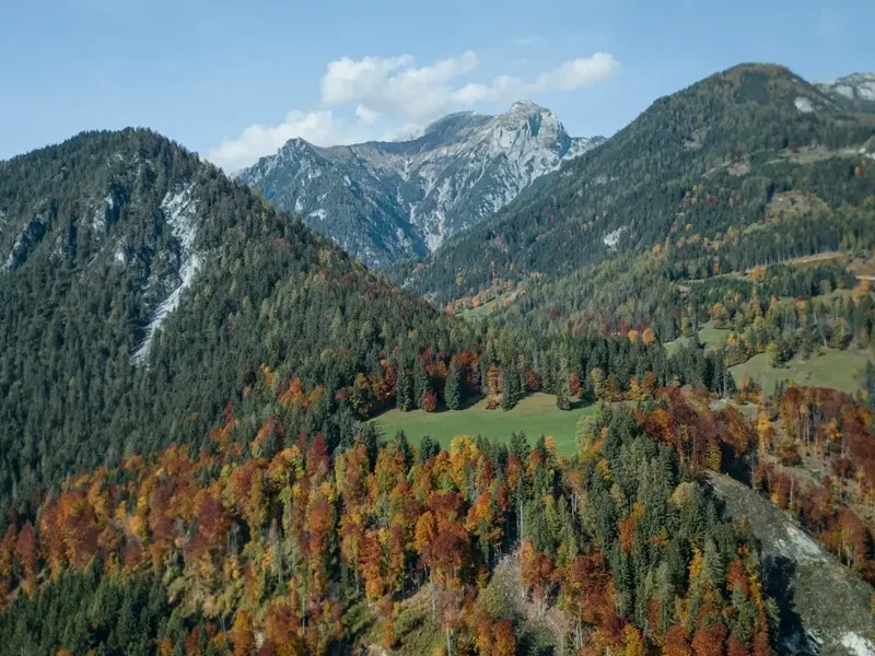
Autumn (September): Many experienced hikers consider September the best month for the Via Augustana. The air becomes exceptionally clear, providing the best long-distance views of the Stubai glaciers and the Dolomites to the south. The crowds thin out, and the larch forests begin their transformation into a brilliant gold. While the days are shorter and the mornings can be frosty, the stability of the weather makes for excellent walking conditions. By early October, many huts begin to close, and the first significant snowfalls of the coming winter can arrive at any time.
Recommended Itinerary
8-Day Via Augustana Itinerary
Day 1: Matrei am Brenner to Maria Waldrast
- Distance: 12 km
- Elevation gain: 750 m
- Time: 4–5 hours
- Start at the historic centre of Matrei am Brenner
- Steady climb through spruce and larch forests
- Pass the Mützens meadows with views back over the Wipptal
- Arrive at Maria Waldrast, one of the highest monasteries in Europe (1,641 m)
- Stay at the monastery guesthouse and sample the "Waldrast water," believed to have healing properties
Day 2: Maria Waldrast to Trins
- Distance: 15 km
- Elevation gain: 400 m
- Time: 5–6 hours
- Follow the "Quellenweg" (Path of Springs) towards the Serles ridge
- Traverse the high-altitude meadows of the Blaser, famous for its botanical diversity
- Descend into the Gschnitztal, a pristine side valley
- Arrive in the mountaineering village of Trins
- Explore the traditional farmhouse architecture of the village
Day 3: Trins to Obernberg am Brenner
- Distance: 18 km
- Elevation gain: 600 m
- Time: 6–7 hours
- Climb out of the Gschnitztal towards the Trunajoch pass
- Spectacular views of the Tribulaun massifs (limestone peaks)
- Descend into the Obernbergtal, often cited as one of the most beautiful valleys in the Tyrol
- Pass the historic St. Nikolaus church
- Stay in a local guesthouse in the quiet village of Obernberg
Day 4: Obernberg Lake Circuit and Gries am Brenner
- Distance: 14 km
- Elevation gain: 350 m
- Time: 4–5 hours
- Morning walk to the Obernberger See, a stunning alpine lake with a chapel on an island
- Follow the historic smugglers' paths towards the border ridges
- Descend to Gries am Brenner, a key transit point on the Roman road
- Visit the parish church with its impressive ceiling frescoes
Day 5: Gries am Brenner to Sattelbergalm
- Distance: 12 km
- Elevation gain: 800 m
- Time: 4–5 hours
- A significant climb following the old military roads
- Pass through the "Grenzkamm" (border ridge) area
- Arrive at the Sattelbergalm, a high-altitude hut with panoramic views
- This section offers a deep dive into the 20th-century history of the border region
Day 6: Sattelbergalm to Gossensass (Italy/South Tyrol)
- Distance: 16 km
- Elevation gain: 300 m (mostly descent)
- Time: 5–6 hours
- Cross the Brenner Pass, the lowest crossing point of the main Alpine ridge
- Follow the "Eisacktal" (Isarco Valley) cycle and hiking path
- Descend into the Italian South Tyrol, where German and Italian cultures blend
- Arrive in Gossensass (Colle Isarco), a historic spa town
Day 7: Gossensass to Sterzing (Vipiteno)
- Distance: 18 km
- Elevation gain: 200 m
- Time: 5–6 hours
- Walk through the lush valley floor following the Eisack River
- Pass the ruins of Schloss Strassberg
- Enter the medieval town of Sterzing, one of the "Borghi più belli d'Italia"
- Marvel at the Zwölferturm (Tower of the Twelve) and the colourful merchant houses
Day 8: Sterzing to Franzensfeste
- Distance: 25 km (can be shortened by train)
- Elevation gain: 100 m
- Time: 7–8 hours
- Final long stretch through the narrow Eisack gorge
- Pass the historic Mauls and Mittewald villages
- Finish at the massive Franzensfeste Fortress, a 19th-century Austrian fortification
- Take the train back to Innsbruck or continue south to Brixen
Planning and Bookings
Book Your Trip
Everything you need to plan your journey
Accommodation
Find places to stay near Innsbruck
Flights
Search flights to Innsbruck
Essential Preparation
The Via Augustana requires careful logistical planning, particularly regarding transport and accommodation. While the trail is well-marked with the yellow Austrian Alpine Club signs and the specific "Via Claudia Augusta" logo, carrying a detailed 1:25,000 scale map is essential. Fitness is a key consideration; while the paths are not technical, walking for 8 consecutive days with a pack requires endurance. It is recommended to undertake several day hikes with a weighted pack in the weeks leading up to the trip.
Innsbruck serves as the primary gateway. It is a major transport hub with an international airport and excellent rail connections to Munich, Vienna, and Zurich. From Innsbruck, the S-Bahn (suburban train) runs every 30 minutes to Matrei am Brenner, making the trailhead exceptionally easy to reach. If you are driving, Matrei has long-term parking options, though returning by train from the finish point is the most efficient method.
Trail Accommodation
Accommodation on the Via Augustana is a highlight of the experience, ranging from high-altitude mountain huts to historic village inns. In the Austrian section, you will primarily stay in "Gasthöfe" (guesthouses) and "Alms" (mountain pastures with lodging).
Hut and Guesthouse Facilities:
- Private rooms or "Lager" (dormitory-style bunks)
- Half-board options (breakfast and a multi-course dinner) are standard and highly recommended
- Hot showers are usually available, though sometimes for a small fee (2–4 Euros) in high-altitude huts
- Drying rooms for wet gear and boots
- Wi-Fi is common in village guesthouses but intermittent or non-existent in mountain Alms
Booking Requirements:
- Bookings should be made at least 3–4 months in advance for the peak July–August season
- Many Alms only accept cash; ensure you carry enough Euros for your stay
- Costs: Expect to pay 60–90 Euros per person per night for half-board in a guesthouse, or 40–60 Euros in a mountain hut
- Membership in an Alpine Club (e.g., ÖAV, DAV) provides significant discounts in many mountain huts
Required Gear
- Hiking boots: Mid-to-high cut with a Vibram-style sole. Ensure they are well broken-in to prevent blisters on the long descents
- Rain protection: A high-quality waterproof jacket (minimum 20,000mm hydrostatic head) and overtrousers. Alpine storms are sudden and heavy
- Backpack: 35–45 litres is sufficient for hut-to-hut walking. Use a waterproof liner or rain cover
- Clothing: A layering system is vital. Include merino wool base layers, a fleece or down mid-layer, and quick-drying trekking trousers
- Navigation: Physical maps (Kompass or Alpenvereinskarte), a compass, and a GPS device or smartphone with offline maps (e.g., Outdooractive or Komoot)
- Sun protection: High-factor sunscreen, sunglasses (Category 3 or 4), and a wide-brimmed hat. The UV radiation is intense at 2,000 metres
- First aid: Blister plasters (Compeed), antiseptic cream, painkillers, and any personal medication
What to Bring
- Hut sleeping bag: A lightweight silk or cotton liner is mandatory in all mountain huts for hygiene
- Water storage: At least 2 litres of capacity. While there are many springs, some sections are dry
- Snacks: Energy bars, nuts, and dried fruit. Most guesthouses will provide a "Lunchpaket" for a small fee
- Cash: Essential for small huts, mountain cafes, and some village shops
- Power bank: To keep your phone and GPS charged, as plug sockets can be limited in older huts
- Toiletries: Biodegradable soap and travel-sized essentials. Don't forget a small travel towel
- Earplugs: Essential for a good night's sleep in dormitory accommodation
Permits
One of the great advantages of the Via Augustana is that no formal permits or entry fees are required to walk the trail. The route makes use of public rights of way, historic roads, and forest tracks that are open to all. However, there are several "soft" requirements and costs that walkers must be aware of to ensure a smooth journey.
Accommodation Bookings: While not a permit, your booking confirmations serve as your "itinerary" and are often required if you are using a luggage transfer service. During the high season, turning up at a hut without a reservation is strongly discouraged and may result in being turned away if the hut is at capacity.
Fishing and Camping: Wild camping is strictly prohibited in the Tyrol region, especially in protected forest areas and alpine meadows. Fines are heavy and enforced by local foresters. If you wish to camp, you must use designated campsites, which are mostly located in the valley floors near towns like Gries am Brenner or Sterzing. Similarly, fishing in the alpine lakes and rivers requires a local license and the permission of the water rights holder.
Mountain Rescue Insurance: While not a legal permit, having insurance that covers mountain rescue (including helicopter evacuation) is essential. The cost of a private helicopter rescue in the Alps can exceed 5,000 Euros. Membership in the Austrian Alpine Club (ÖAV) or an equivalent national body usually includes this insurance as part of the annual fee, which is approximately 60–70 Euros.
Cross-Border Considerations: As the trail crosses from Austria into Italy at the Brenner Pass, you should carry a valid ID or passport. While both countries are part of the Schengen Area and there are rarely formal border checks for hikers, you are legally required to have identification on your person.
Other Activities in the Area
The region surrounding the Via Augustana is a hub for outdoor adventure and Tyrolean culture. Consider adding a few days to your itinerary to explore these options:
- Innsbruck City Exploration: Visit the Golden Roof (Goldenes Dachl), the Imperial Palace, and take the Nordkette cable car directly from the city centre to 2,256 metres for a bird's-eye view of the Inn Valley.
- Swarovski Crystal Worlds: Located in nearby Wattens, this is one of Austria's most visited attractions—a surreal subterranean world of crystal art and installations.
- Bergisel Ski Jump: A masterpiece of modern architecture by Zaha Hadid, offering incredible views and a fascinating look at the history of ski jumping.
- Stubai Glacier: For those who haven't had enough of the heights, the Stubai Glacier offers year-round snow experiences and a "Top of Tyrol" viewing platform at 3,210 metres.
- Brenner Outlet Shopping: For a change of pace, the Brenner Pass features a large outlet mall where you can find international brands at discounted prices—a popular stop for those finishing the hike.
- Traditional Tyrolean Evenings: Many villages host weekly "Tiroler Abende" featuring folk music, Schuhplattler dancing, and local gastronomy.
Safety and Conditions
Alpine Weather Hazards: The primary safety concern on the Via Augustana is the weather. Conditions can change from bright sunshine to freezing rain or snow within an hour. Afternoon thunderstorms are common in July and August. If you see dark, towering cumulus clouds forming, seek lower ground or shelter immediately. Lightning is a significant risk on ridges and open meadows.
Navigation and Terrain: While the trail is well-marked, fog and low cloud can obscure markers. Always carry a compass and know how to use it in conjunction with your map. The terrain is generally stable, but heavy rain can make limestone paths slippery and cause small rockfalls in steeper sections. Stay on the marked path to avoid disturbing unstable scree slopes.
Livestock and Wildlife: You will frequently walk through pastures containing cattle or horses. These animals are generally docile but can be protective of their young. Give them a wide berth, do not attempt to pet or feed them, and keep dogs on a short lead. If a cow charges, stay calm, do not run, and slowly move out of its path. Ticks are present in the lower forest and meadow sections; perform a daily check and know how to remove them correctly.
Emergency Numbers:
- European Emergency Number: 112
- Austrian Mountain Rescue: 140
- Italian Mountain Rescue: 118
Side Trips and Points of Interest
The Serles Summit: For fit hikers staying at Maria Waldrast, a sunrise ascent of the Serles (2,717 m) is a classic Tyrolean experience. Known as the "Altar of the Tyrol," the summit offers an unobstructed view of the Stubai Alps and the city of Innsbruck far below. The climb adds about 1,100 metres of elevation and requires an extra day.
Obernberger See: Even if you are just passing through, take the time to walk the full circuit of this lake. The water is a startling turquoise colour due to the limestone minerals, and the reflection of the Obernberger Tribulaun in the still morning water is one of the most photographed sights in the region.
The Roman Milestone at Gries: Near the village of Gries am Brenner, you can find a replica of a Roman milestone (the original is in a museum). It marks the distance to Augsburg and serves as a tangible link to the soldiers who marched this same path 2,000 years ago.
Mining History in Gossensass: The area around Gossensass was once a wealthy silver mining district. You can visit old adits and learn about the medieval mining techniques that once made this valley one of the richest in Europe.
Leave No Trace
The alpine environment is extremely sensitive to human impact. At high altitudes, the growing season is short, and damage to vegetation can take decades to heal. As a walker on the Via Augustana, you are a guest in a landscape that supports rare species like the Edelweiss and the Alpine Marmot.
Principles for the Via Augustana:
- Pack it in, pack it out: There are no rubbish bins on the mountain trails. Carry all your waste, including organic scraps like banana skins (which do not decompose quickly in the cold alpine air), back to the valleys.
- Stick to the path: "Short-cutting" switchbacks causes erosion and destroys the delicate root systems that hold the soil in place.
- Respect the water: Do not use soap or detergents in alpine lakes or streams. Even biodegradable soap can harm sensitive aquatic life.
- Leave what you find: It is illegal to pick wildflowers in the Tyrol. Take a photograph instead; it lasts longer and doesn't damage the ecosystem.
- Be quiet: Loud noise can stress wildlife and disturbs the peace that other hikers have come to find.
- Human waste: Use the facilities at the huts and guesthouses. If you are caught short, ensure you are at least 50 metres from water, dig a small hole, and pack out your toilet paper in a sealed bag.