Via Alpina (Swiss Segment) - A Trans-Alpine Journey
The Via Alpina is a network of long-distance hiking trails that traverse the Alps, connecting eight countries. The Swiss segment, often referred to as the Via Alpina 1 (VA1), is a spectacular 390-kilometre journey that winds its way through the heart of the Swiss Alps, from the eastern border near Sargans to the western shores of Lake Geneva. This challenging trek offers an unparalleled immersion into the diverse landscapes of Switzerland, from verdant valleys and alpine meadows dotted with wildflowers to dramatic glaciated peaks and crystal-clear mountain lakes. It is a route that demands physical endurance and rewards with breathtaking vistas, charming alpine villages, and a profound connection with the majestic alpine environment.
- Distance: 390.0 km
- Duration: 14–20 days
- Elevation Gain: 23,600 m
- Difficulty: Challenging
- Best Time: June to September (July and August ideal for wildflowers and stable weather)
- Closest City: Lucerne (for onward travel from trail endpoints)
- Trailhead Access: Weisstannen (start) to Montreux (end)
- Permits: No specific permits required for the trail itself, but accommodation and some cable cars may need booking.
Overview
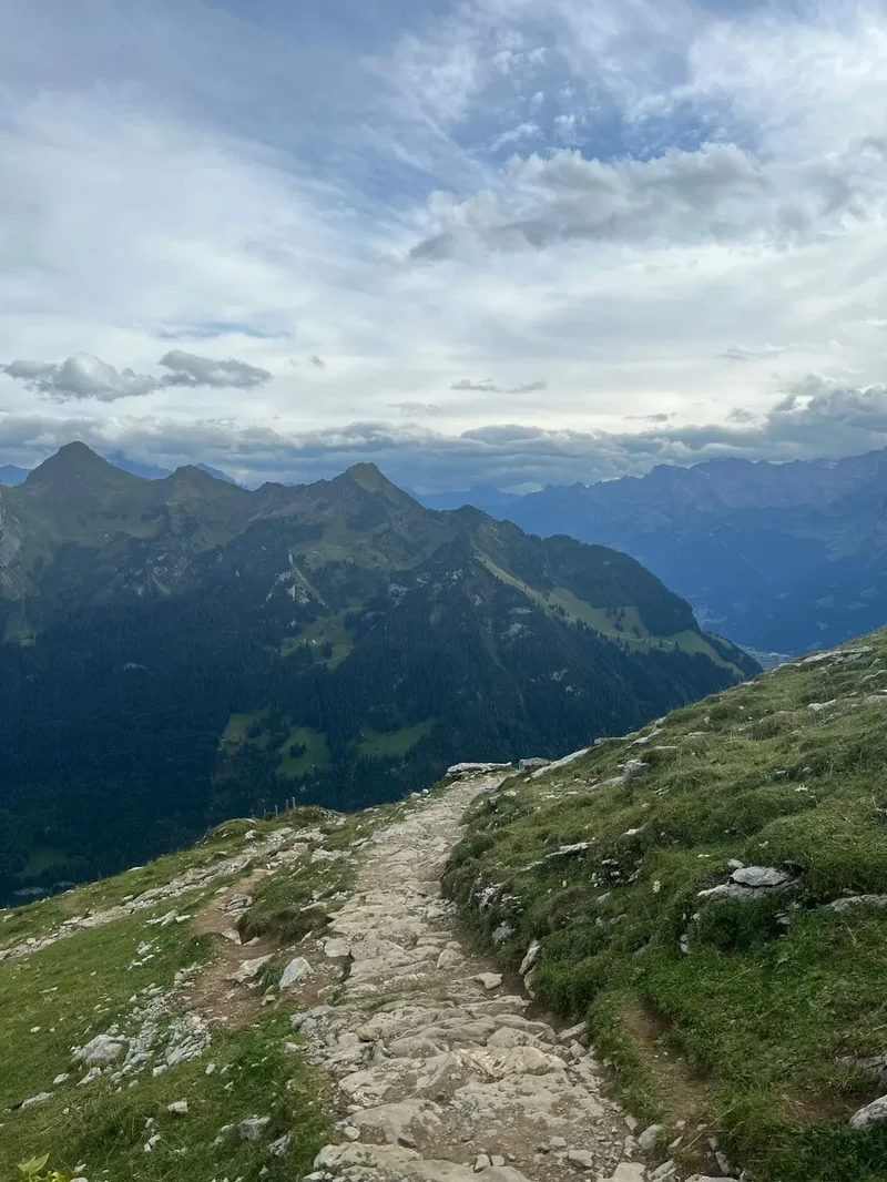
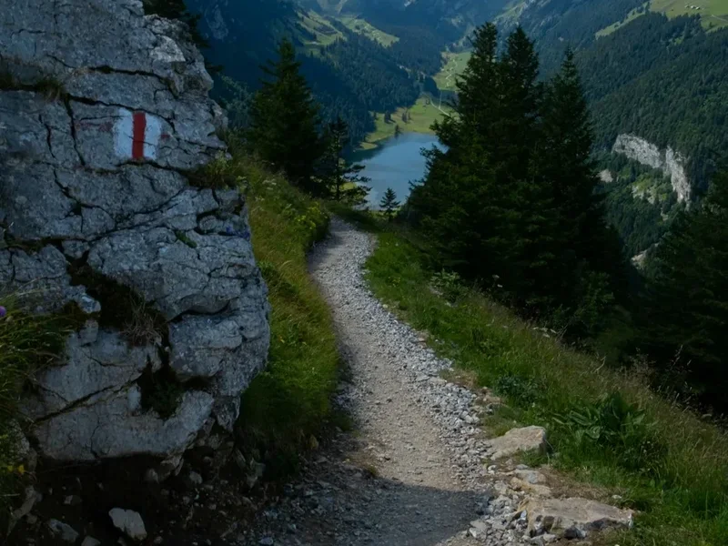
The Swiss Via Alpina is a true alpine traverse, a demanding yet incredibly rewarding trek that showcases the very best of Switzerland's mountainous terrain. Unlike some more manicured trails, the VA1 embraces the wilder side of the Alps, taking walkers through remote valleys, over high passes, and past remote mountain huts. The route is meticulously waymarked with yellow signs featuring a red mountain symbol, ensuring navigation is generally straightforward, though the sheer scale of the terrain and potential for rapidly changing weather demand a high level of self-sufficiency and preparedness.
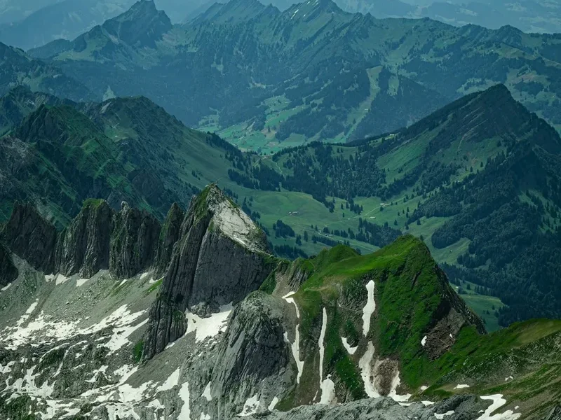
The journey begins in the picturesque village of Weisstannen in the canton of St. Gallen, nestled in a valley that feels a world away from the bustling cities. From here, the trail ascends steeply, quickly immersing you in the alpine environment. Over the next two weeks, you will traverse a remarkable variety of landscapes. Expect to hike through lush, flower-strewn alpine meadows in the early summer, witness the stark beauty of scree slopes and rocky ridges as you gain altitude, and marvel at the imposing presence of glaciers clinging to the highest peaks. The route often crosses high mountain passes, offering panoramic views that stretch for miles, revealing a tapestry of snow-capped summits, deep valleys, and shimmering lakes.
The Swiss Via Alpina is not just about the grand vistas; it's also about the intimate encounters with alpine life. You'll pass through traditional farming hamlets where cowbells echo through the valleys, discover hidden waterfalls cascading down sheer rock faces, and perhaps even spot elusive wildlife such as chamois or marmots. The trail's progression is a testament to the diverse geological history of the Alps, from the sedimentary layers of the eastern ranges to the more dramatic, glaciated landscapes of the central and western Alps.
This trek is a significant undertaking, requiring a good level of fitness and experience in mountain hiking. The cumulative elevation gain is substantial, and daily distances can be long, often involving steep ascents and descents. However, for those who embrace the challenge, the Swiss Via Alpina offers an unforgettable adventure, a chance to disconnect from the everyday and reconnect with the raw, untamed beauty of the European Alps.
History and Cultural Context
The concept of the Via Alpina emerged in the late 20th century as a collaborative effort between Alpine countries to create a network of long-distance trails that would promote trans-national understanding and appreciation for the Alpine environment. The Swiss segment, being centrally located and boasting some of the most iconic Alpine scenery, forms a crucial backbone of this network.
Historically, the routes that the Via Alpina now follows have been used for centuries by local communities for trade, pastoralism, and seasonal migration. Ancient mule tracks, shepherd's paths, and military routes have been incorporated into the modern trail, offering a tangible link to the past. The villages and hamlets encountered along the way often have a rich history tied to agriculture, mining, and early tourism. For instance, many regions were historically important for cheese production, with alpine pastures being vital for summer grazing.
The development of mountaineering and hiking as recreational pursuits in the 19th and 20th centuries further shaped the use of these mountain paths. Swiss Alpine Clubs played a significant role in mapping, maintaining, and promoting these routes, making them accessible to a wider audience. The establishment of mountain huts provided essential refuges for travellers, evolving from simple shelters to well-equipped establishments that are now integral to the experience of hiking the Via Alpina.
The Via Alpina project itself, initiated in the 1980s, aimed to create a unified vision for the Alps, recognising their shared natural heritage and the need for sustainable tourism. The Swiss section, in particular, benefits from Switzerland's well-developed infrastructure and commitment to preserving its natural landscapes, while still offering a genuine wilderness experience. The trail's path often reflects historical settlement patterns and the economic activities that shaped the Alpine regions over generations.
Seasonal Highlights and Weather Reality
The Swiss Via Alpina is a summer and early autumn trek. The optimal window for hiking is from June to September. During these months, the snow generally recedes from the higher passes, and the alpine meadows burst into bloom.
June: Early June can still see significant snow cover on higher passes, especially in shaded areas or at higher elevations. Wildflowers are beginning to emerge in the lower valleys, but the higher alpine regions may still be inaccessible or require snow gear. The weather can be unpredictable, with a higher chance of late snowfalls.
July and August: This is peak season. The alpine meadows are typically at their most vibrant, carpeted with a dazzling array of wildflowers. The weather is generally more stable, though afternoon thunderstorms are common in the mountains. Days are long, providing ample daylight for hiking. This is also the busiest period, so accommodation in huts and popular villages should be booked well in advance.
September: September offers a beautiful transition into autumn. The crowds thin out, and the air becomes crisp and clear. The larch trees begin to turn golden, creating spectacular autumnal colours in the landscape. While generally stable, the weather can become more unpredictable, with a higher chance of early snowfalls, particularly towards the end of the month. Some mountain huts may begin to close towards the end of September.
Weather Considerations: The Alps are notorious for their rapidly changing weather. Even in the height of summer, hikers can encounter sunshine, heavy rain, strong winds, hail, and even snow within a single day. Temperatures can fluctuate significantly with altitude and time of day. It is crucial to be prepared for all conditions, regardless of the season. Hypothermia is a risk even in summer at higher elevations.
Recommended Itinerary
14-Day Via Alpina (Swiss Segment) Itinerary Example
Day 1: Weisstannen to Elm
- Distance: 18 km
- Elevation Gain: 1,300 m
- Elevation Loss: 900 m
- Time: 6–7 hours
- Start in Weisstannen, a charming village in the St. Gallen Rhine Valley.
- Ascend steeply through forests and alpine pastures towards the Foopass.
- Enjoy panoramic views from the Foopass.
- Descend into the Sernf Valley to the village of Elm.
Day 2: Elm to Glarus
- Distance: 22 km
- Elevation Gain: 1,100 m
- Elevation Loss: 1,300 m
- Time: 7–8 hours
- A challenging day crossing the Panixerpass.
- Steep ascent to the Panixerpass, offering dramatic mountain scenery.
- Descend into the remote Panixer Valley.
- Continue to the town of Glarus, a larger settlement with more amenities.
Day 3: Glarus to Linthal
Day 4: Linthal to Urnerboden (Klausen Pass)
- Distance: 12 km
- Elevation Gain: 1,000 m
- Elevation Loss: 500 m
- Time: 4–5 hours
- Ascend the iconic Klausen Pass.
- Stunning views from the pass, marking the transition into the canton of Uri.
- Descend to Urnerboden, a high alpine hamlet.
Day 5: Urnerboden to Engelberg
- Distance: 25 km
- Elevation Gain: 1,500 m
- Elevation Loss: 1,600 m
- Time: 8–9 hours
- A long and demanding day over the Surenenpass.
- Steep ascent to the Surenenpass, with potential for snow early in the season.
- Descend through alpine terrain towards Engelberg, a popular mountain resort.
Day 6: Engelberg to Melchsee-Frutt
- Distance: 18 km
- Elevation Gain: 1,200 m
- Elevation Loss: 800 m
- Time: 6–7 hours
- Ascend towards the high alpine plateau of Melchsee-Frutt.
- Pass by beautiful mountain lakes, including the iconic Melchsee.
- Overnight in the resort village of Melchsee-Frutt.
Day 7: Melchsee-Frutt to Innertkirchen
- Distance: 20 km
- Elevation Gain: 900 m
- Elevation Loss: 1,400 m
- Time: 7–8 hours
- Descend from the plateau into the Bernese Oberland.
- Pass through charming alpine hamlets.
- Arrive in Innertkirchen, a village in the Haslital valley.
Day 8: Innertkirchen to Grindelwald
- Distance: 15 km
- Elevation Gain: 1,000 m
- Elevation Loss: 700 m
- Time: 5–6 hours
- Ascend towards the famous Eiger region.
- Pass through alpine pastures with views of the Eiger, Mönch, and Jungfrau.
- Arrive in the renowned mountain resort of Grindelwald.
Day 9: Grindelwald to Lauterbrunnen
- Distance: 12 km
- Elevation Gain: 600 m
- Elevation Loss: 800 m
- Time: 4–5 hours
- A scenic day with stunning views of the Jungfrau massif.
- Descend into the dramatic Lauterbrunnen Valley, known for its 72 waterfalls.
- Explore the valley floor and its impressive cascades.
Day 10: Lauterbrunnen to Kandersteg
- Distance: 25 km
- Elevation Gain: 1,400 m
- Elevation Loss: 1,200 m
- Time: 8–9 hours
- A long and challenging day crossing the Hohtürli Pass.
- Steep ascent to the Hohtürli Pass, offering spectacular views of the Oeschinensee lake.
- Descend to the charming village of Kandersteg.
Day 11: Kandersteg to Adelboden
- Distance: 18 km
- Elevation Gain: 900 m
- Elevation Loss: 800 m
- Time: 6–7 hours
- Ascend towards the Hahnenmoos Pass.
- Pass through alpine meadows and forests.
- Arrive in the popular resort village of Adelboden.
Day 12: Adelboden to Les Diablerets
- Distance: 28 km
- Elevation Gain: 1,600 m
- Elevation Loss: 1,700 m
- Time: 9–10 hours
- A very long and demanding day crossing the Col des Mosses.
- Traverse high alpine terrain with expansive views.
- Descend into the valley towards Les Diablerets, a gateway to the Vaud Alps.
Day 13: Les Diablerets to Rochers de Naye
- Distance: 20 km
- Elevation Gain: 1,200 m
- Elevation Loss: 1,000 m
- Time: 7–8 hours
- Ascend towards the Rochers de Naye, a prominent peak overlooking Lake Geneva.
- Enjoy increasingly dramatic views of the lake and surrounding mountains.
- Overnight near Rochers de Naye or descend to a lower village.
Day 14: Rochers de Naye to Montreux
- Distance: 8 km
- Elevation Gain: 200 m
- Elevation Loss: 1,000 m
- Time: 3–4 hours
- A final, shorter descent to the shores of Lake Geneva.
- Enjoy the transition from alpine scenery to the Mediterranean-like climate of the lake region.
- Arrive in Montreux, a beautiful town on the Swiss Riviera, marking the end of the Via Alpina.
Important Notes:
- This is a sample itinerary; distances and times can vary based on specific route choices and personal pace.
- Accommodation in mountain huts and villages should be booked well in advance, especially during peak season (July-August).
- Cable cars and public transport can be used to shorten some days or bypass difficult sections if needed, but this deviates from the pure trail experience.
- Always check weather forecasts and trail conditions before setting out each day.
- Carry sufficient food and water, as services can be sparse between villages.
Planning and Bookings
Book Your Trip
Everything you need to plan your journey
Accommodation
Find places to stay near Lucerne
Flights
Search flights to Lucerne
Essential Preparation
The Via Alpina (Swiss Segment) is a long-distance trek that requires careful planning and preparation. Given its length and challenging terrain, it's crucial to be physically fit and mentally prepared for multi-day hiking in an alpine environment. Start by assessing your fitness level and gradually increase your training regimen, focusing on cardiovascular endurance, leg strength, and carrying a weighted pack. Familiarise yourself with map reading and navigation skills, as while the trail is well-marked, conditions can sometimes obscure the path.
Logistics are key. Decide on your preferred pace and whether you will be camping or staying in huts and guesthouses. Research accommodation options along the route and book them in advance, particularly during the peak summer months (July and August), as popular mountain huts and village inns can fill up quickly. Consider your start and end points; Weisstannen is accessible by public transport, and Montreux offers excellent onward travel connections. Factor in potential delays due to weather, which are common in the Alps.
The closest major international airport to the start of the Swiss Via Alpina is Zurich (ZRH). From Zurich Airport, you can take a train to Sargans (approximately 1.5 hours), then a local train to Ziegelbrücke, followed by a bus to Weisstannen. Alternatively, driving is an option, with parking available in Weisstannen, though it can be limited. For the end point, Montreux is easily accessible by train from major Swiss cities and airports.
Trail Accommodation
Accommodation along the Swiss Via Alpina varies significantly, ranging from basic mountain huts (SAC Huts - Swiss Alpine Club) to charming village inns and hotels. Booking in advance is highly recommended, especially for huts and popular guesthouses during the peak season (July-August).
Mountain Huts (SAC Huts):
- Booking Requirements: Most SAC huts require advance booking, especially for overnight stays. Some have online booking systems, while others may require a phone call or email. Membership in the Swiss Alpine Club (SAC) often provides discounted rates and priority booking.
- Facilities Provided: Huts typically offer dormitory-style sleeping quarters with mattresses and blankets. They usually have a communal dining area, a kitchen (often with gas stoves, but bring your own cookware), and basic toilet facilities (sometimes composting toilets). Some may have running water, but it's always advisable to treat water from natural sources.
- What's NOT Provided: Sleeping bags (a liner is usually mandatory), food (though some huts offer meals for purchase), cooking utensils, personal toiletries, and electricity for charging devices are generally not provided.
- Seasonal Availability: Most SAC huts are open from late June to mid-September or early October, depending on the altitude and snow conditions. Some may offer limited winter services.
- Costs: Prices vary, but expect to pay approximately CHF 30-60 per night for non-members, with discounts for SAC members.
Village Inns and Hotels:
- Booking Requirements: Essential to book in advance, especially in popular tourist destinations like Grindelwald, Lauterbrunnen, and Montreux.
- Facilities Provided: Standard hotel amenities, including private rooms, en-suite bathrooms, restaurants, and often Wi-Fi.
- What's NOT Provided: Specific to each establishment, but generally you'll need to bring your own toiletries and personal items.
- Seasonal Availability: Generally available year-round, but prices and availability fluctuate with the tourist season.
- Costs: Can range from CHF 80-200+ per night for a double room, depending on the location and standard.
Camping: Wild camping is generally discouraged or prohibited in many parts of Switzerland, especially in nature reserves and above the tree line. Designated campsites are available in some villages, but they are not a common feature along the high alpine sections of the Via Alpina.
Required Gear
- Sturdy Hiking Boots: Waterproof, broken-in hiking boots with good ankle support are essential for navigating varied alpine terrain.
- Waterproof and Windproof Outerwear: A high-quality waterproof and breathable jacket and trousers are non-negotiable due to the unpredictable mountain weather.
- Warm Layers: Multiple layers of synthetic or merino wool clothing (base layers, mid-layers like fleece or down jacket) are crucial for adapting to temperature changes.
- Sleeping Bag: A 3-season sleeping bag (comfort rating around 0-5°C) is required for mountain huts. A sleeping bag liner is mandatory in most SAC huts.
- Backpack: A comfortable backpack of 45-65 litres, with a good hip belt and rain cover, is needed to carry your gear.
- Navigation Tools: Detailed topographic maps of the region, a compass, and a GPS device or smartphone with offline maps are vital. The trail is marked, but visibility can be poor.
- Head Torch: With spare batteries, for use in huts and during early morning or late evening hikes.
- First-Aid Kit: Comprehensive kit including blister treatment, pain relievers, antiseptic wipes, bandages, and any personal medications.
- Sun Protection: High SPF sunscreen, sunglasses, and a wide-brimmed hat or cap. The sun is intense at altitude.
- Trekking Poles: Highly recommended for reducing strain on knees during descents and providing stability on uneven terrain.
What to Bring
- Food Supplies: While some huts offer meals, it's wise to carry high-energy snacks (nuts, dried fruit, energy bars) and potentially some lightweight meals for lunches or if you plan to self-cater in huts.
- Water Bottles/Hydration Reservoir: Carry at least 2-3 litres of water capacity. Water sources are available, but purification (filter or tablets) is recommended.
- Toiletries: Biodegradable soap, toothbrush, toothpaste, small towel, hand sanitiser.
- Personal Items: Camera, power bank for electronics, book or journal, insect repellent (especially for lower altitudes and evenings).
- Duct Tape and Repair Kit: For minor gear repairs.
- Cash: Many mountain huts and smaller establishments may not accept credit cards, so carry sufficient Swiss Francs (CHF).
- Emergency Whistle: For signalling in emergencies.
- Plastic Bags: For waterproofing items and packing out rubbish.
Permits
The Via Alpina (Swiss Segment) does not require specific permits for hikers to traverse the trail itself. Switzerland has a strong tradition of public access to its natural landscapes, and the marked trails are generally open to all. However, it is crucial to understand that while the trail is free to use, accommodation and certain transport options along the route will incur costs and often require advance booking.
Accommodation Bookings:
- Mountain Huts (SAC Huts): As mentioned in the accommodation section, booking is essential, especially during the peak season (July-August). While not a "permit," securing a bed is a prerequisite for staying in these facilities.
- Hotels and Guesthouses: Similarly, booking accommodation in villages and towns along the route is highly recommended and often necessary to guarantee a place to stay.
Cable Cars and Public Transport: If you choose to use cable cars, gondolas, or public transport to shorten sections of the hike or for scenic excursions, these will require purchasing tickets. Prices vary depending on the route and operator.
National Park Regulations: While the Via Alpina primarily traverses open alpine terrain and passes through villages, it may cross through or near designated nature reserves or national parks. It is important to be aware of and adhere to any specific regulations in these areas, such as restrictions on camping, fires, or disturbing wildlife. However, these are generally well-signposted and do not typically require special permits for through-hikers.
General Advice: Always carry identification and sufficient cash, as not all establishments accept credit cards, particularly in remote mountain areas. Familiarise yourself with Swiss laws regarding public access and environmental protection to ensure a responsible and enjoyable trek.
Other Activities in the Area
The regions traversed by the Via Alpina offer a wealth of activities beyond hiking, allowing for a richer and more varied experience:
- Mountaineering and Climbing: For experienced individuals, the Swiss Alps offer numerous opportunities for climbing and mountaineering, with guided ascents of peaks like the Eiger, Mönch, and Jungfrau accessible from Grindelwald and Lauterbrunnen.
- Via Ferrata: Several sections of the Via Alpina pass near via ferrata routes, offering a thrilling way to experience steep rock faces with fixed cables and ladders.
- Paragliding and Hang Gliding: Popular in areas like Grindelwald and Interlaken, offering breathtaking aerial views of the Alps.
- Mountain Biking: Many regions have dedicated mountain bike trails, providing an alternative way to explore the alpine landscape.
- Scenic Train Journeys: Switzerland is renowned for its panoramic train routes, such as the Jungfrau Railway (to the "Top of Europe") or the Glacier Express, which can be incorporated into or extend your trip.
- Lake Cruises: On reaching Lake Geneva, enjoy a leisurely cruise on the lake, visiting charming lakeside towns like Montreux and Lausanne.
- Visiting Alpine Villages: Take time to explore the unique character of villages like Elm, Glarus, Grindelwald, Lauterbrunnen, and Kandersteg, experiencing local culture, cuisine, and history.
- Museums and Cultural Sites: Many towns and villages have local museums detailing the history of alpine life, farming, and mountaineering.
Safety and Conditions
Weather Preparedness: The most significant safety concern on the Via Alpina is the unpredictable mountain weather. Always check the latest weather forecast from reliable sources like MeteoSwiss or local mountain weather services before setting out each day. Be prepared for rapid changes, including sudden storms, heavy rain, strong winds, fog, and even snow, regardless of the season. Hypothermia is a real risk, even in summer, at higher altitudes.
Navigation: While the Via Alpina is well-marked with yellow signs, it is essential to carry and know how to use topographic maps, a compass, and a GPS device or smartphone with offline maps. Visibility can drop dramatically in fog or snow, making navigation challenging. Stay on marked trails to avoid dangerous terrain and protect the fragile alpine environment.
Altitude and Physical Exertion: The cumulative elevation gain is substantial, and many days involve steep ascents and descents. Ensure you are physically fit and acclimatised. Listen to your body, take breaks when needed, and do not push yourself beyond your limits. Be aware of the symptoms of altitude sickness, though it is less common on this route compared to much higher treks.
Terrain Hazards: Be mindful of loose scree, slippery rocks, and steep drop-offs, especially on pass crossings. Use trekking poles for stability. In early season, snow bridges over streams can be unstable, and snowfields may require careful crossing or alternative routes.
Water Sources: While water is generally plentiful from streams and springs, it is advisable to treat all water using a filter or purification tablets, especially in lower altitudes or areas with livestock grazing. Always fill up your water bottles whenever you have the opportunity.
Communication: Mobile phone reception can be intermittent or non-existent in many remote alpine areas. Consider carrying a personal locator beacon (PLB) or satellite messenger for emergencies, especially if hiking solo or in remote sections.
Emergency Contacts: Know the emergency numbers for Switzerland (144 for ambulance, 112 for general emergency). Inform someone of your itinerary and expected return date.
Wildlife: While encounters are rare, be aware of potential wildlife such as chamois, ibex, and marmots. Do not approach or feed wild animals. Ticks can be present in grassy areas at lower altitudes; check yourself for ticks after hiking.
Side Trips and Points of Interest
The Via Alpina (Swiss Segment) is rich with opportunities for exploration beyond the main trail:
Oeschinensee Lake (near Kandersteg): A stunning turquoise alpine lake accessible via a short hike from the Hohtürli Pass descent or by cable car from Kandersteg. It's a popular spot for swimming, boat rentals, and enjoying the dramatic mountain scenery.
Jungfraujoch - Top of Europe (near Grindelwald): While not directly on the Via Alpina, the train journey from Grindelwald or Lauterbrunnen to Jungfraujoch offers unparalleled access to the high alpine world, with views of the Aletsch Glacier and surrounding peaks. This is a significant detour and requires a full day.
Trümmelbach Falls (Lauterbrunnen Valley): A series of ten powerful glacial waterfalls inside the mountain, made accessible by a tunnel-lift. They are a spectacular display of nature's power.
Aletsch Glacier: The longest glacier in the Alps, visible from various viewpoints in the Bernese Oberland. While the Via Alpina doesn't traverse it, its presence is a constant reminder of the glacial forces that shaped the landscape.
Chillon Castle (Lake Geneva): Located near Montreux, this beautifully preserved medieval castle on the shores of Lake Geneva is a significant historical landmark and a worthwhile visit at the end of your trek.
Local Cheese Dairies: Many alpine villages have traditional cheese dairies where you can learn about and sample local Swiss cheeses, a delicious part of the regional culture.
Villages and Hamlets: Take time to explore the unique architecture, local traditions, and culinary offerings of the various villages along the route, such as Elm, Glarus, Engelberg, Grindelwald, Lauterbrunnen, Kandersteg, and Adelboden.
Leave No Trace
The Swiss Alps are a pristine and sensitive environment, and adhering to Leave No Trace principles is paramount for preserving their beauty and ecological integrity for future generations. The Via Alpina passes through diverse ecosystems, from lush forests and meadows to fragile alpine tundra and rocky scree slopes.
Plan Ahead and Prepare: Research your route, understand the terrain, and be aware of potential hazards. Book accommodation in advance to avoid overcrowding and ensure responsible use of facilities. Pack appropriately for all weather conditions to minimise the need for emergency services.
Travel and Camp on Durable Surfaces: Stick to marked trails to avoid damaging vegetation and causing erosion. In designated camping areas (where permitted), camp on established sites. Avoid camping in sensitive areas like meadows or near water sources.
Dispose of Waste Properly: Pack out everything you pack in, including all food scraps, wrappers, and any other litter. Use designated toilets in huts and villages. If no facilities are available, dig a cathole at least 60 metres away from water, trails, and campsites, and bury human waste. Pack out used toilet paper.
Leave What You Find: Do not remove or disturb natural objects such as rocks, plants, or flowers. Respect cultural heritage sites and historical markers.
Minimise Campfire Impacts: Campfires are generally prohibited in most alpine areas and national parks in Switzerland. Use a lightweight stove for cooking instead. If fires are permitted in specific designated areas, use existing fire rings and ensure fires are completely extinguished before leaving.
Respect Wildlife: Observe wildlife from a distance. Never feed animals, as it can disrupt their natural behaviours and diets, and can be harmful to their health. Store food securely to prevent attracting animals.
Be Considerate of Other Visitors: Keep noise levels down, especially in huts and at campsites. Yield to other hikers on narrow trails. Respect the tranquility of the alpine environment.