Via Alpina (Purple Route) - The Heart of the Swiss Alps
The Via Alpina (Purple Route) represents one of the most spectacular segments of the international Via Alpina network, specifically traversing the dramatic landscapes of the Bernese Oberland in Switzerland. Covering 132.0 kilometres of world-class alpine terrain, this journey is a masterclass in mountain aesthetics, taking walkers through a landscape defined by the "Big Three"—the Eiger, Mönch, and Jungfrau. This is not merely a hike; it is a high-altitude pilgrimage through the cradle of mountaineering history, where traditional dairy farming cultures coexist with some of the most sophisticated mountain infrastructure on the planet. Over the course of 8 to 10 days, hikers will ascend a staggering 8,400 metres of cumulative elevation, crossing formidable mountain passes that link hidden valleys, turquoise glacial lakes, and ancient stone-built villages.
- Distance: 132.0 km
- Duration: 8–10 days
- Elevation Gain: 8,400 m
- Difficulty: Challenging (requires high fitness and mountain experience)
- Highest Point: Hohtürli Pass (2,778 m)
- Best Time: July to September
- Closest City: Interlaken
- Trailhead: Innertkirchen
- Finish: Lenk / Gstaad region
Overview
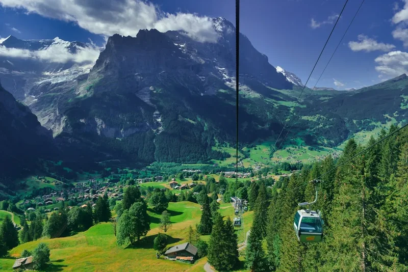
The Via Alpina (Purple Route) through Switzerland is widely considered the most visually rewarding section of the entire five-route Via Alpina system. While the broader network spans eight countries from Slovenia to Monaco, this specific 132-kilometre stretch captures the quintessential Swiss alpine experience. The route is characterised by its "up and over" nature; almost every day involves descending into a lush, cow-dotted valley floor only to climb over a high-altitude col or pass into the next drainage system. This rhythmic progression provides a constantly shifting perspective of the Bernese Alps, moving from the limestone precipices of the Wetterhorn to the dark, brooding north face of the Eiger.
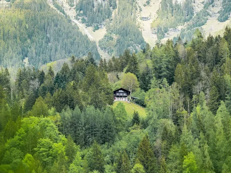
The terrain is varied and demanding. Walkers will navigate everything from well-groomed gravel paths and flower-strewn meadows to technical scree slopes, exposed ridgelines, and steep stone staircases. The physical challenge is significant—averaging over 1,000 metres of ascent per day—but the rewards are unparalleled. You will walk through the Lauterbrunnen Valley, famous for its 72 waterfalls, and stand beneath the massive glaciers of the Blüemlisalp massif. The route is also a cultural journey; the sound of heavy cowbells is the constant soundtrack to the hike, and the scent of woodsmoke and fermenting hay defines the village stays. Unlike wilderness treks in North America or New Zealand, the Via Alpina is a "civilised" adventure, where a hard day's climb is almost always rewarded with a stay in a historic mountain hut or a traditional village guesthouse, complete with local Alpkäse (alpine cheese) and fresh bread.
Logistically, the route is exceptionally well-supported. The Swiss "Yellow Signpost" system is arguably the best trail marking in the world, providing accurate time estimates and clear directions at every junction. This allows hikers to focus on the scenery and the physical effort rather than constant navigation. However, the "Purple Route" designation implies a level of seriousness; the weather can change from sweltering summer heat to a full-blown alpine blizzard within an hour, and the steepness of the passes requires strong knees and a steady head for heights. For those with the stamina, it offers a definitive European trekking experience that balances raw natural power with centuries of human heritage.
History and Cultural Context
The history of the Via Alpina is inextricably linked to the development of the Alps as a shared European heritage. The trail network was formally established in 2000 as a cross-border project to promote sustainable development and tourism in the Alpine regions. However, the paths themselves are far older. Many segments of the Purple Route follow ancient transhumance tracks used for centuries by Swiss farmers to move cattle to high-altitude summer pastures (the "Alps"). This seasonal migration is so central to Swiss identity that it has been recognised by UNESCO as intangible cultural heritage. As you walk, you will see the "Senn" (alpine herders) still practicing these traditions, producing cheese in high huts using methods that have changed little since the Middle Ages.
The Bernese Oberland section also holds a special place in the history of the "Golden Age" of mountaineering. In the mid-19th century, British explorers and local Swiss guides used these valleys as base camps for the first ascents of the region's giants. The village of Grindelwald, which the trail passes through, became the epicentre of this movement. The Eiger North Face, visible for several days of the trek, remains one of the most storied and feared precipices in the world, its history written in the triumphs and tragedies of climbers who sought to conquer its "White Spider" ice field. Walking the Via Alpina allows you to tread the same ground as these pioneers, albeit on more established paths.
Culturally, the route traverses the linguistic and architectural heart of German-speaking Switzerland. The houses are masterpieces of timber craftsmanship, often adorned with painted proverbs and intricate carvings. The land is managed with a precision that can seem almost manicured to outsiders, but this is the result of a deep-seated respect for the "Heimat" (homeland) and a communal effort to protect the fragile mountain ecology. Understanding this connection between the people and the peaks adds a profound layer of meaning to the physical journey.
Want more background? Read extended notes on history and cultural context → Learn more
Seasonal Highlights and Weather Reality
The window for successfully completing the Via Alpina (Purple Route) is relatively narrow due to the high elevation of the passes. While lower sections may be accessible in late spring, the high cols like the Hohtürli (2,778 m) often remain choked with snow until well into July. Consequently, the peak season is strictly July through September.
July and August: This is the height of summer. The alpine wildflowers are at their most vibrant, with gentians, alpenrose, and occasionally edelweiss carpeting the meadows. The weather is generally stable, though afternoon thunderstorms are a common occurrence. These storms can be violent, with heavy rain and lightning, making it essential to reach your destination or a safe shelter by mid-afternoon. Temperatures in the valleys can reach 25–30°C, while the passes remain cool, often around 10–15°C.
September: Many experienced hikers consider this the best month. The air is crisper and clearer, providing the best visibility for photography. The summer crowds have thinned, and the "cattle drives" (Desalpe) begin, where decorated cows are led down from the high pastures to the valleys—a spectacular cultural sight. However, the days are shorter, and the first dusting of autumn snow can arrive on the high passes, potentially making them slippery or impassable without traction aids.
The Foehn Wind: A critical weather phenomenon to understand is the Foehn—a warm, dry wind that can sweep across the Alps. While it brings exceptionally clear skies and warm temperatures, it can also reach hurricane force on the ridges, making walking dangerous and causing rapid temperature fluctuations. Always consult the local "MeteoSwiss" forecast, which provides specific warnings for Foehn conditions.
Recommended Itinerary
9-Day Via Alpina (Purple Route) Itinerary
Day 1: Innertkirchen to Grosse Scheidegg
- Distance: 15 km
- Elevation gain: 1,350 m
- Time: 5–6 hours
- Start in the quiet village of Innertkirchen, following the Reichenbach River
- Pass the famous Reichenbach Falls, where Sherlock Holmes famously met his "end"
- Steady climb through dense forest and open pastures
- Spectacular views of the Wellhorn and Wetterhorn peaks as you approach the pass
- Stay at the historic Berghotel Grosse Scheidegg, situated directly on the col
Day 2: Grosse Scheidegg to Grindelwald
- Distance: 10 km
- Elevation gain: 200 m (mostly descent)
- Time: 3–4 hours
- A shorter day allowing for recovery or exploration of Grindelwald
- Walk beneath the massive limestone walls of the Wetterhorn
- Gentle descent through the "Upper Grindelwald Glacier" area
- Arrival in the bustling mountaineering hub of Grindelwald
- Excellent views of the Eiger North Face throughout the afternoon
Day 3: Grindelwald to Lauterbrunnen (via Kleine Scheidegg)
- Distance: 19 km
- Elevation gain: 1,100 m
- Time: 6–7 hours
- The "Classic" stage: climbing toward the base of the Eiger
- Pass through Alpiglen and follow the Eiger Trail beneath the North Face
- Reach Kleine Scheidegg, the junction for the Jungfrau Railway
- Long descent into the Lauterbrunnen Valley, the "Valley of 72 Waterfalls"
- Stay in Lauterbrunnen or the car-free village of Wengen perched above
Day 4: Lauterbrunnen to Griesalp
- Distance: 21 km
- Elevation gain: 1,500 m
- Time: 8–9 hours
- One of the most strenuous days of the route
- Climb out of the valley toward the Sefinenfurgge Pass (2,612 m)
- Cross the pass into the Kiental Valley
- Steep, technical descent on shale and scree (cables provided in sections)
- Arrive in the remote and peaceful hamlet of Griesalp
Day 5: Griesalp to Kandersteg (via Hohtürli)
- Distance: 14 km
- Elevation gain: 1,450 m
- Time: 7–8 hours
- The "Queen Stage" of the trek, crossing the highest point at Hohtürli (2,778 m)
- Incredibly steep ascent on wooden steps and scree
- Optional side trip to the Blüemlisalphütte for lunch with glacier views
- Descent past the stunning Oeschinensee, a turquoise lake surrounded by cliffs
- Finish in the resort town of Kandersteg
Day 6: Kandersteg to Adelboden
- Distance: 16 km
- Elevation gain: 1,200 m
- Time: 5–6 hours
- Climb to the Bunderchrinde Pass (2,385 m)
- Dramatic rock formations and views back toward the Kander Valley
- Descent into the traditional Engstligen Valley
- Arrival in Adelboden, famous for its wooden chalets and world-cup skiing history
Day 7: Adelboden to Lenk
- Distance: 14 km
- Elevation gain: 750 m
- Time: 4–5 hours
- A more moderate day crossing the Hahnenmoos Pass
- Wide, easy paths through rolling alpine meadows
- Views of the Wildstrubel massif
- Descent into Lenk, a beautiful village at the head of the Simmental Valley
Day 8: Lenk to Lauenen
- Distance: 13 km
- Elevation gain: 900 m
- Time: 5 hours
- Climb to the Trüttlisberg Pass
- Transition from the high limestone peaks to the gentler, greener mountains of the Saanenland
- Descent into the idyllic village of Lauenen, immortalised in Swiss folk songs
Day 9: Lauenen to Gstaad
- Distance: 10 km
- Elevation gain: 300 m
- Time: 3 hours
- A final, celebratory stroll through the meadows
- Pass the Lauenensee (lake) if taking the scenic detour
- Finish in the world-famous, upscale resort of Gstaad
- Excellent train connections back to Interlaken or Zurich
Important Notes:
- The itinerary can be shortened by using the extensive network of cable cars and mountain railways (e.g., the gondola from Kandersteg to Oeschinensee).
- Accommodation should be booked well in advance, especially for July and August.
- The Sefinenfurgge and Hohtürli passes are very steep; trekking poles are highly recommended.
- Water is generally available at troughs in pastures, but treatment is advised due to livestock.
Planning and Bookings
Book Your Trip
Everything you need to plan your journey
Accommodation
Find places to stay near Interlaken
Flights
Search flights to Interlaken
Essential Preparation
The Via Alpina (Purple Route) is a serious undertaking that requires a high level of cardiovascular fitness and leg strength. You will be climbing and descending over 1,000 metres on most days, often on steep and uneven terrain. Training should focus on hill repeats with a weighted pack and building endurance for 6–8 hour days. If you are not accustomed to high altitudes, consider spending two days in Interlaken or Innertkirchen (600 m) before starting to acclimatise.
Logistically, the Swiss Travel Pass is an invaluable tool. While you are walking, you may need to use buses, trains, or cable cars to bypass sections or reach accommodation. The pass covers most public transport and offers significant discounts on mountain railways. Interlaken is the best base for pre-hike logistics, offering large supermarkets (Coop and Migros) for supplies and numerous outdoor retailers for gear.
Trail Accommodation
Accommodation on the Via Alpina is a highlight of the experience, ranging from rugged mountain huts to luxury valley hotels. There are three main types of stay:
SAC Huts (Swiss Alpine Club): These are high-altitude shelters like the Blüemlisalphütte. They offer dormitory-style sleeping (Matratzenlager) with shared blankets. Half-board (dinner and breakfast) is standard and highly recommended. You must bring a silk or cotton sleeping bag liner. Booking is essential via the SAC online portal. Costs are approximately 80–100 CHF for half-board.
Berghotels and Guesthouses: Located on passes or in smaller hamlets (like Grosse Scheidegg or Griesalp). These offer a mix of private rooms and smaller dorms. They provide a more comfortable experience with hot showers and extensive menus. Prices range from 70 CHF (dorm) to 150+ CHF (private room).
Valley Hotels: In towns like Grindelwald, Lauterbrunnen, and Kandersteg, you have the full range of Swiss hospitality. These are perfect for "rest days" where you can do laundry and enjoy a wider variety of food. Prices vary wildly but expect to pay 120–200 CHF for a mid-range hotel.
Note on Camping: Wild camping is generally prohibited in Switzerland, especially in forest reserves and national parks. There are designated campsites in the valley towns (Grindelwald, Lauterbrunnen, Kandersteg), but carrying a tent significantly increases your pack weight on the steep passes.
Required Gear
- Footwear: Sturdy, waterproof trekking boots with high ankle support and a stiff sole (Vibram or similar). The terrain is rocky and can be slippery when wet.
- Clothing: A layering system is vital. Include moisture-wicking base layers (merino wool is best), a fleece or down mid-layer, and a high-quality waterproof/breathable shell jacket (Gore-Tex).
- Navigation: While the trail is well-marked, you must carry a topographic map (1:25,000 or 1:50,000) and a compass. A GPS or smartphone with offline maps (e.g., Outdooractive or SwissTopo) is highly recommended.
- Safety Gear: A basic first aid kit (including blister care like Compeed), an emergency whistle, and a space blanket.
- Trekking Poles: Almost non-negotiable for this route. They save your knees on the 1,500 m descents and provide stability on scree slopes.
What to Bring
- Water System: At least 2 litres of capacity. A hydration bladder or lightweight bottles. While there are many fountains, some are marked "Kein Trinkwasser" (not drinking water).
- Snacks: High-energy food like nuts, dried fruit, and Swiss chocolate. While you can buy lunch at mountain huts, having your own supplies is cheaper and safer.
- Sun Protection: High-factor sunscreen (SPF 50+), sunglasses with Category 3 or 4 lenses, and a wide-brimmed hat. The alpine sun is exceptionally strong.
- Personal Items: A lightweight travel towel, biodegradable soap, and a silk sleeping bag liner for huts.
- Cash: While most places take cards, some remote mountain huts only accept Swiss Francs (CHF) or prefer them for small purchases.
- Power: A portable power bank. Outlets in mountain huts are limited and often in high demand.
Permits
One of the great advantages of the Via Alpina (Purple Route) is that no formal permits are required to walk the trail. There are no daily quotas or entry fees for the path itself. However, the "permit" equivalent in Switzerland is your accommodation booking. Because wild camping is restricted and the route is popular, your ability to do the trek is entirely dependent on securing a bed each night.
Booking Strategy:
- For the peak months of July and August, you should aim to book your mountain huts (SAC) and guesthouses at least 3–4 months in advance.
- If you are travelling solo, you can often find a spot in a dormitory at shorter notice, but groups of two or more will struggle without prior arrangements.
- Use the Swiss Alpine Club (SAC) central booking system for high huts. For valley hotels, standard booking platforms work well.
Costs and Currency:
- Switzerland is expensive. Budget approximately 100–150 CHF per day for food and accommodation if staying in a mix of huts and modest hotels.
- The currency is the Swiss Franc (CHF). While Euros are sometimes accepted in tourist hubs, the exchange rate offered is usually poor. It is best to use CHF or a travel card with low FX fees.
Other Activities in the Area
The Bernese Oberland is a world-class tourism destination, and it is worth adding a few days to your itinerary to experience the following:
- Jungfraujoch - Top of Europe: Take the cogwheel train to the highest railway station in Europe (3,454 m). You can walk on the Aletsch Glacier, visit the Ice Palace, and see the Sphinx Observatory.
- Schilthorn - Piz Gloria: Famous for the James Bond film "On Her Majesty's Secret Service," this peak offers a 360-degree revolving restaurant and a "Thrill Walk" over the cliffs.
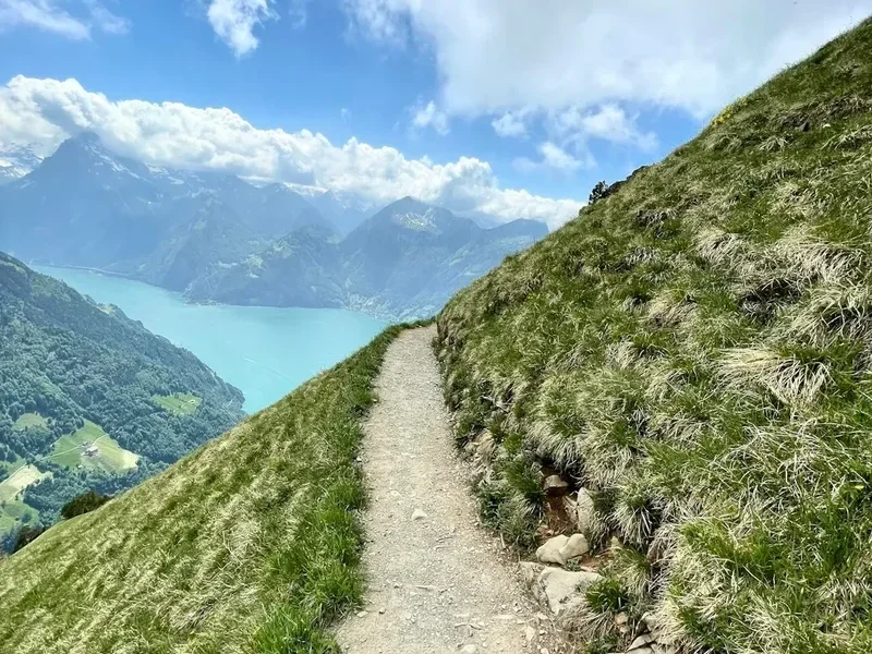
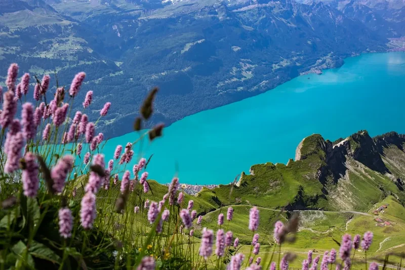
- Lake Brienz and Lake Thun: After days of climbing, a boat cruise on these turquoise lakes is the perfect way to rest your legs. The woodcarving village of Brienz is particularly charming.
- Trümmelbach Falls: Located in the Lauterbrunnen Valley, these are ten glacial waterfalls inside the mountain, made accessible by a tunnel lift. They drain the mighty glaciers of the Eiger, Mönch, and Jungfrau.
- Paragliding in Interlaken: See the mountains you've been walking from a completely different perspective. Interlaken is one of the world's premier spots for tandem paragliding.
Safety and Conditions
The Via Alpina is a high-mountain route, and safety should be your primary concern. The most significant risks are weather-related. Even in mid-summer, snow can fall on the Hohtürli or Sefinenfurgge, making the steep paths treacherous. If visibility is low, navigation becomes difficult, and the risk of a fall increases.
Alpine Hazards:
- Lightning: If a storm approaches while you are on a pass or ridgeline, descend immediately. Avoid standing near isolated trees or metal cables.
- Cows: While they look peaceful, mother cows can be protective of their calves. Give them a wide berth, do not pet them, and keep dogs on a short lead. If a cow approaches aggressively, stay calm and slowly move away.
- Rockfall: In steep limestone areas, rockfall is a natural occurrence. Be mindful when crossing scree slopes, especially if there are hikers above you.
- Dehydration and Heat: The climb out of Lauterbrunnen or Meiringen can be sweltering. Drink plenty of water and use electrolyte replacements.
Emergency Services: The emergency number in Switzerland is 144 for medical emergencies and 1414 for REGA (Swiss Air Rescue). It is highly recommended to become a "REGA Patron" for a small fee (approx. 40 CHF), which can waive the costs of a helicopter rescue if your insurance does not cover it.
Side Trips and Points of Interest
The Eiger Trail: On Day 3, instead of the standard path, take the Eiger Trail from Alpiglen to Kleine Scheidegg. This path runs directly at the foot of the Eiger North Face. You can see the fixed ropes used by climbers and gain a true sense of the wall's verticality. It adds about an hour to the day but is a highlight of the entire route.
Oeschinensee: On Day 5, don't rush past this lake. It is often voted the most beautiful lake in the Alps. You can rent a rowing boat or take a swim (it's cold!) before the final descent to Kandersteg. There is also a mountain coaster (rodelbahn) near the gondola station for a bit of high-speed fun.
Blüemlisalphütte: Even if you aren't staying the night, the 15-minute climb from the Hohtürli pass to the hut is worth it for the "Nut Cake" (Nusstorte) and the view of the ice falls on the Blüemlisalp glacier.
Mürren: If you have an extra day, stay in the car-free village of Mürren. It sits on a cliff edge 800 metres above the Lauterbrunnen valley floor and offers the most iconic view of the Eiger, Mönch, and Jungfrau lined up in a row.
Leave No Trace
The Swiss Alps are a heavily used but meticulously maintained environment. To preserve this for future generations, hikers must adhere to strict Leave No Trace principles. The ecosystem at 2,500 metres is extremely fragile; a footprint off-trail can destroy plants that take years to grow.
Key Guidelines:
- Stay on the Path: Cutting switchbacks causes erosion and destroys the trail infrastructure.
- Waste Management: Pack out all trash, including organic waste like banana peels or apple cores, which do not decompose quickly at high altitudes and can be harmful to local wildlife.
- Respect the Flora: Many alpine flowers, such as the Edelweiss and certain types of Gentian, are protected by law. Do not pick them.
- Water Protection: Do not use soap (even biodegradable) in alpine lakes or streams. Carry water 50 metres away from the source for washing.
- Quietude: Respect the silence of the mountains. Avoid loud music or shouting, which can disturb both wildlife and fellow hikers.