Via Alpina - The Ultimate Alpine Traverse
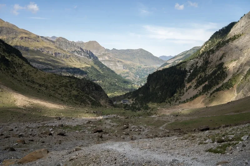
The Via Alpina is a monumental achievement in international trail design, representing a network of five hiking routes spanning the entire length of the European Alps. Crossing eight sovereign nations—Slovenia, Italy, Austria, Germany, Liechtenstein, Switzerland, France, and Monaco—this 5,000-kilometre odyssey is more than just a thru-hike; it is a cultural and ecological bridge across the most iconic mountain range in the world. The Red Trail, the longest and most comprehensive of the five, serves as the backbone of the network, guiding walkers from the shores of the Adriatic Sea in Trieste, through the jagged limestone peaks of the Julian Alps, across the high-altitude glaciers of the Central Alps, and finally down to the Mediterranean glamour of Monaco. With a staggering cumulative elevation gain of over 135,000 metres, the Via Alpina challenges the physical limits of the most seasoned trekkers while offering an unparalleled immersion into the diverse languages, traditions, and landscapes of the Alpine arc.
- Distance: 5,000 km (total network); Red Trail: 2,500 km
- Duration: 4–6 months for a full thru-hike
- Season: June to September (high-altitude passes are snow-bound outside this window)
- Accommodation: Extensive network of mountain huts (Refuges, Rifugi, Hütten, Koče)
- Highest point: 3,019 m (Niederjoch, Similaun Hut, Red Trail)
- Countries: Slovenia, Italy, Austria, Germany, Liechtenstein, Switzerland, France, Monaco
- Difficulty: Challenging (requires high fitness, alpine experience, and navigation skills)
Overview
The Via Alpina is not a single path but a grand tapestry of five distinct routes, each identified by a specific colour: Red, Blue, Yellow, Green, and Purple. Together, they comprise 342 stages, meticulously designed to showcase the geological, biological, and cultural diversity of the Alps. The Red Trail is the flagship route, traversing all eight countries over 161 stages. The Blue Trail focuses on the Western Alps of Switzerland, Italy, and France. The Yellow Trail connects the Adriatic coast to the German plains. The Green Trail offers a shorter, 14-stage traverse of the Swiss Alps, while the Purple Trail explores the Eastern Alps of Austria, Slovenia, and Germany. This project was conceived not only as a recreational challenge but as a tool for sustainable development, encouraging "slow tourism" that supports remote mountain communities often bypassed by modern infrastructure.
Walking the Via Alpina is a lesson in European geography and history. One day you may be traversing the high-altitude karst plateaus of Slovenia, where the echoes of World War I battles still linger in the form of rusted bunkers and trenches. A week later, you could be sitting in a Tyrolean mountain hut, sharing a plate of Kaiserschmarrn while listening to the clanging bells of Haflinger horses. The trail transitions seamlessly from the Mediterranean scrub of the Maritime Alps to the lush, emerald valleys of the Allgäu, and from the sheer granite walls of the Bernese Oberland to the sun-drenched vineyards of the Italian Piedmont. The sheer scale of the journey means that walkers witness the subtle shifts in architecture, dialect, and cuisine that occur every few dozen kilometres, providing a profound understanding of the Alpine identity.
Logistically, the Via Alpina is unique because it relies on the world's most sophisticated mountain infrastructure. Unlike the wilderness thru-hikes of North America, where walkers must carry weeks of food and camp in the wild, the Via Alpina is designed around the "hut-to-hut" system. Every stage typically ends at a mountain refuge or a small village, providing a bed, a warm meal, and a sense of community. However, this convenience does not diminish the challenge. The terrain is frequently steep, technical, and exposed. Walkers must be prepared for sudden alpine storms, navigating across snowfields in mid-summer, and the mental fortitude required to sustain a multi-month effort across some of the most rugged terrain in Europe.
History and Cultural Context
The Via Alpina was officially launched in 2000, the result of an ambitious international collaboration led by the French association "Grande Traversée des Alpes." The project was supported by the European Union and the Alpine Convention—an international treaty for the sustainable development and protection of the Alps. The goal was to create a physical manifestation of a united Europe, using the mountains as a common ground rather than a barrier. By linking existing trails and historical trade routes, the founders created a continuous path that celebrates the shared heritage of the Alpine people while highlighting the unique characteristics of each region.
Historically, the paths that make up the Via Alpina have been used for millennia. They follow the footsteps of Roman legionnaires, medieval salt traders, transhumance shepherds moving their flocks to summer pastures, and 19th-century mountaineers during the "Golden Age" of Alpinism. In the 20th century, many of these routes became the front lines of conflict, particularly in the Julian and Carnic Alps, where the "Isonzo Front" saw some of the most brutal mountain warfare in history. Today, the Via Alpina reclaims these paths for peace and recreation, turning former military mule tracks into avenues for international friendship.
The cultural depth of the trail is immense. In Switzerland, you encounter the Romansh language, a linguistic relic of the Roman Empire. In the Aosta Valley of Italy, French and Italian cultures blend seamlessly. In the German-speaking regions, the "Alm" culture remains a vital part of the economy, with traditional cheese-making techniques still practiced in high-altitude dairies. The trail also passes through numerous UNESCO World Heritage sites, including the Dolomites in Italy and the Jungfrau-Aletsch region in Switzerland, recognising the universal value of these landscapes. For the walker, the Via Alpina is an invitation to become part of this living history, contributing to the preservation of mountain cultures through respectful and sustainable travel.
Want more background? Read extended notes on history and cultural context → Learn more
Seasonal Highlights and Weather Reality
The window for a full Via Alpina thru-hike is dictated entirely by the snow. Most high-altitude passes (above 2,000 metres) remain blocked by snow until late June or early July. Conversely, the first autumn snowfalls typically arrive in late September or early October, effectively closing the high-mountain sections. Therefore, the prime season is from mid-June to mid-September. Those attempting the full Red Trail must time their departure carefully, often starting in the lower-altitude sections of Slovenia or Italy in late May to reach the high Central Alps when the passes are clear.
Summer in the Alps (July and August) offers the most stable weather, with long daylight hours and vibrant alpine meadows in full bloom. This is the time of the "Alpenrausch" (alpine rose) and the sighting of rare edelweiss. However, summer also brings the risk of violent afternoon thunderstorms. These "Gewitter" can develop with terrifying speed, bringing lightning, hail, and sudden temperature drops. Walkers must aim to cross high passes by midday to avoid being caught in exposed areas during the afternoon storm window.
The shoulder seasons offer their own rewards. September is often considered the best month for hiking in the Alps; the air is crisp and clear, the summer crowds have dissipated, and the "Föhn" wind can provide exceptionally long-range visibility. However, days are shorter, and morning frosts become common. In the lower-altitude sections, such as the Maritime Alps near the Mediterranean, hiking is possible well into October, but the high-altitude huts in the interior will have closed their doors by then, requiring more self-sufficiency.
Winter on the Via Alpina is the domain of expert ski mountaineers and is not recommended for standard trekking. The trail becomes a landscape of extreme avalanche danger, and many sections are completely impassable without specialised equipment and deep knowledge of snow stability. For the vast majority of walkers, the Via Alpina is a summer-only endeavour, where the challenge lies in managing the transition from the heat of the valleys to the freezing winds of the high cols.
Recommended Itinerary
The Red Trail: A Cross-Continental Journey
Section 1: The Adriatic and the Julian Alps (Slovenia/Italy)
- Distance: ~250 km
- Key Waypoints: Trieste, Lipica, Triglav National Park, Vršič Pass
- The journey begins at sea level in Trieste, Italy, before crossing into Slovenia.
- Experience the unique Karst landscape, famous for its caves and white Lipizzaner horses.
- Enter the Julian Alps, dominated by Mount Triglav (2,864 m). The terrain becomes rugged limestone, with steep climbs and dramatic ridgelines.
- Stay in traditional Slovenian "Koče" (huts), known for their hearty soups and warm hospitality.
Section 2: The Carnic and Dolomites (Italy/Austria)
- Distance: ~350 km
- Key Waypoints: Plöcken Pass, Sesto/Sexten, Drei Zinnen (Tre Cime), Val Gardena
- The trail follows the border ridge between Italy and Austria, often traversing old military paths from WWI.
- Enter the Dolomites, a UNESCO World Heritage site. The scenery shifts to vertical pale-grey towers and deep green valleys.
- The hiking here is world-class, with well-maintained paths and some of the most luxurious mountain huts in the world (Rifugi).
- Key challenge: Navigating the high-altitude plateaus and managing the significant daily elevation changes.
Section 3: The Central Alps and Tyrol (Austria/Germany)
- Distance: ~400 km
- Key Waypoints: Pitztal, Ötztal, Karwendel Mountains, Oberstdorf
- This section features the highest point of the Red Trail at the Similaun Hut (3,019 m), near where Ötzi the Iceman was discovered.
- Traverse the massive glaciers and granite peaks of the Ötztal and Stubai Alps.
- Cross into Germany to experience the Allgäu Alps, characterised by steep grass mountains and traditional dairy farming.
- The infrastructure here is exceptional, with the German and Austrian Alpine Clubs (DAV/ÖAV) maintaining a vast network of "Hütten."
Section 4: The Swiss Heart (Liechtenstein/Switzerland)
- Distance: ~500 km
- Key Waypoints: Vaduz, Glarus Alps, Bernese Oberland, Grindelwald, Meiringen
- After a brief traverse of the Principality of Liechtenstein, the trail enters the heart of Switzerland.
- The Bernese Oberland provides the most iconic scenery of the entire trip: the Eiger, Mönch, and Jungfrau massifs.
- Expect high-altitude passes like the Kleine Scheidegg and the Hohtürli, offering views of massive glaciers.
- Swiss "Sac-Hütten" are highly organised and often located in spectacular, precarious positions.
Section 5: The Western Arc (Italy/France)
- Distance: ~600 km
- Key Waypoints: Aosta Valley, Gran Paradiso, Queyras, Mercantour National Park
- The trail turns south, following the border between France and Italy. This is the wildest and most remote section of the Via Alpina.
- Pass through the Gran Paradiso National Park, home to large herds of ibex and chamois.
- The Queyras and Mercantour regions offer a mix of high alpine terrain and Mediterranean influence.
- The "Refuges" become smaller and more rustic, and the language shifts between Italian and French dialects.
Section 6: The Mediterranean Finish (France/Monaco)
- Distance: ~150 km
- Key Waypoints: Sospel, La Turbie, Place du Palais (Monaco)
- The final descent towards the sea. The air becomes warmer, and the vegetation shifts to olive trees and lavender.
- The trail ends with a dramatic view of the Mediterranean before descending into the Principality of Monaco.
- The finish line is the Place du Palais, a stark contrast to the wilderness of the previous months.
Important Notes:
- The Red Trail consists of 161 stages; most walkers choose to complete specific sections rather than the full thru-hike in one go.
- Hut bookings are essential during July and August, especially in popular areas like the Dolomites and Bernese Oberland.
- The trail is marked with the Via Alpina logo, but local trail numbers and names are often more prominent.
- Water is generally available at huts, but high-altitude karst regions (Slovenia/Dolomites) can be dry.
- Always carry a physical map or a reliable GPS with offline maps, as cloud cover can make navigation difficult.
Planning and Bookings
Book Your Trip
Everything you need to plan your journey
Accommodation
Find places to stay near Geneva
Flights
Search flights to Geneva
Essential Preparation
Planning a journey on the Via Alpina requires a multi-layered approach. For a full thru-hike, preparation should begin at least six to nine months in advance. The primary challenge is not just physical fitness, but the logistical coordination of 161 stages across eight countries. You must decide whether to walk the entire Red Trail or focus on specific sections. Fitness requirements are high; you should be comfortable walking 15–25 kilometres per day with 1,000+ metres of elevation gain, carrying a 10–12 kilogram pack, for weeks on end.
Base cities like Geneva, Innsbruck, Ljubljana, and Nice serve as excellent starting points or resupply hubs. Most trailheads are accessible via the superb European rail and bus network. For example, the start in Trieste is easily reached by train from Venice, while the Swiss sections are perfectly integrated with the SBB (Swiss Federal Railways). It is highly recommended to join an Alpine Club (such as the DAV, ÖAV, CAI, or SAC). Membership provides significant discounts on hut accommodation (often 50%), priority booking, and comprehensive mountain rescue insurance, which is essential for this trail.
Trail Accommodation
The Via Alpina is designed as a hut-to-hut trail. These mountain refuges are the lifeblood of the Alpine hiking experience. They range from large, hotel-like structures with private rooms and hot showers to remote, unmanned bivouacs with basic wooden bunks.
Hut Facilities:
- Dormitory-style sleeping (Matratzenlager) with blankets and pillows provided.
- Half-board options (Halbpension) including a multi-course dinner and breakfast.
- Drying rooms for wet gear and boots.
- Common rooms for socialising and route planning.
- Basic washing facilities (hot showers often cost extra, e.g., €3–€5 for 3 minutes).
- Charging stations for electronics (though these can be limited in remote huts).
What Huts Don't Provide:
- Sleeping bags or linens (a lightweight silk or cotton liner is mandatory for hygiene).
- Towels and toiletries.
- Free drinking water in some karst regions (bottled water must be purchased).
- Reliable WiFi or mobile signal (many huts are in "dead zones").
Booking Requirements:
- Bookings are essential in peak season (July–August). Many huts now use online booking platforms like "Hütten-Holiday" or "Alpenvereinaktiv."
- Costs vary by country: €50–€80 for half-board (with Alpine Club discount) is a standard average. Switzerland is generally more expensive (€80–€110).
- Wild camping is strictly regulated. In many parts of the Alps (especially National Parks and Switzerland), it is illegal and can result in heavy fines. Always check local regulations before pitching a tent.
Required Gear
- Mountain boots - Category B or B/C, waterproof (Gore-Tex), with a stiff sole for rocky terrain.
- Technical backpack - 35–50L capacity with a high-quality suspension system and rain cover.
- Layering system - Merino wool base layers, a fleece or "active" mid-layer, and a lightweight down or synthetic puffy jacket for evenings.
- Hardshell jacket - Professional grade (Gore-Tex Pro or similar) to withstand heavy alpine rain and wind.
- Trekking poles - Essential for saving knees on long descents and providing stability on snowfields.
- Navigation - GPS device (Garmin/Suunto) and a smartphone with offline maps (Outdooractive, Komoot, or Gaia GPS).
- Hut liner - Silk or cotton (mandatory for sleeping in mountain huts).
- Head torch - For navigating dark dormitories and early morning starts.
- First aid kit - Focus on blister care (Compeed), antiseptic, and personal medications.
What to Bring
- Water treatment - While tap water in huts is usually safe, a lightweight filter (Sawyer Squeeze) or tablets are useful for stream water.
- Cash - Many remote huts do not accept credit cards. Carry sufficient Euros and Swiss Francs.
- Sun protection - High-altitude sun is intense. SPF 50+ sunscreen, lip balm with UV protection, and Category 3 or 4 sunglasses.
- Emergency gear - A lightweight emergency bivvy bag and a whistle.
- Personal items - Quick-dry travel towel, biodegradable soap, and earplugs (essential for dormitories).
- Food/Snacks - While huts provide meals, you need "trail food" for lunch (nuts, dried fruit, energy bars, local cheese, and bread).
- Power bank - To keep navigation devices charged during multi-day stretches between villages.
- Alpine Club card - To secure discounts and insurance.
Permits
One of the great advantages of the Via Alpina is that there is no single "thru-hiking permit" required to walk the trail. Because it crosses international borders within the Schengen Area, most walkers (depending on their nationality) can move freely between the eight countries without passport checks. However, there are several specific regulations and "permits" of a different nature that you must be aware of to ensure a legal and respectful journey.
Wild Camping Regulations: This is the most critical "permit" issue. Unlike the United States, there is no general right to camp along the trail.
- Slovenia: Wild camping is strictly prohibited, especially in Triglav National Park. Fines are high.
- Italy: Regulations vary by region, but it is generally forbidden below the treeline and in protected areas. An "emergency bivouac" (sunset to sunrise) is sometimes tolerated in high-altitude areas.
- Austria and Germany: Generally prohibited in forests and protected areas. Some regions have designated "Trekkingplätze" (campsites) that must be booked in advance.
- Switzerland: Very strict. Prohibited in National Parks, wildlife resets, and many cantons. Above the treeline, a single-night bivouac is often tolerated, but you must check local cantonal laws.
- France: More relaxed. Bivouacking (setting up at dusk, leaving at dawn) is often allowed in National Parks (like Mercantour or Vanoise) but only at a certain distance from park boundaries or huts.
National Park Access: While entry to the National Parks is free, certain activities (like bringing dogs or using drones) are strictly regulated or require specific permits. Drones are almost universally banned in Alpine National Parks to protect wildlife and the peace of other hikers.
Fishing and Hunting: If you plan to fish in alpine lakes, you must obtain local permits (often available at village tourist offices or post offices). These are strictly enforced.
Insurance: While not a permit, mountain rescue insurance is effectively mandatory. If you require a helicopter evacuation in the Alps and do not have insurance (such as that provided by Alpine Club membership), the cost can exceed €5,000–€10,000. Ensure your policy specifically covers "search and rescue" and "repatriation."
Other Activities in the Area
The Alps offer a playground that extends far beyond the hiking trail. Consider these activities to enrich your Via Alpina experience:
- Via Ferrata: Especially in the Dolomites and the Julian Alps, these "iron paths" allow non-climbers to experience vertical terrain using fixed cables, ladders, and bridges. Requires specific gear (harness, lanyard, helmet).
- Mountaineering: Use the Via Alpina as a base to summit iconic peaks like the Grossglockner (Austria), Triglav (Slovenia), or the Breithorn (Switzerland). Many huts are starting points for guided climbs.
- Alpine Thermal Spas: After weeks of walking, reward your muscles in the thermal baths of Bad Gastein (Austria), Bormio (Italy), or Leukerbad (Switzerland).
- Canyoning and Rafting: The valleys of the Soča (Slovenia) and the Ötztal (Austria) offer world-class white-water adventures.
- Cultural Festivals: Time your visit to coincide with the "Almabtrieb" (cattle drive) in September, where cows are decorated with flowers as they return from summer pastures.
- Paragliding: Experience the Alps from above. Tandem flights are available in almost every major valley, particularly in Interlaken and Chamonix.
- Cheese Tasting: Visit "Show Dairies" (Sennereien) in the Allgäu or the Gruyère region to see how traditional mountain cheeses are made.
Safety and Conditions
Pre-Departure Checks:
- Check the local mountain weather forecast (e.g., MeteoSwiss, ZAMG in Austria, ARSO in Slovenia) every morning.
- Consult hut wardens about trail conditions, especially regarding remaining snow on high passes in early summer.
- Ensure your mobile phone is fully charged and you have the local emergency numbers saved (112 is the universal emergency number for all eight countries).
- Inform the hut warden of your intended destination for the day.
Alpine Hazards: The primary danger on the Via Alpina is the weather. Rapid temperature drops, fog that reduces visibility to metres, and lightning are genuine threats. If caught in a thunderstorm, move away from ridges, isolated trees, and wire cables (Via Ferrata). Snowfields can persist on north-facing slopes well into August; crossing these without an ice axe or traction devices (crampons/spikes) can be dangerous if the snow is hard-frozen. Rockfall is also a risk, particularly in the limestone regions of the Dolomites and Julian Alps.
Navigation: While the trail is generally well-marked, markings can be obscured by snow or fog. In some regions, the Via Alpina logo is small and infrequent. You must be proficient in reading topographic maps and using a compass or GPS. Do not rely solely on a smartphone, as batteries drain quickly in cold temperatures and GPS signals can be erratic in deep valleys.
Physical Health: Overuse injuries (tendonitis, blisters) are common on thru-hikes. Listen to your body and take rest days in villages. Tick-borne diseases (Lyme disease and TBE) are present in the lower-altitude forests of the Alps; use repellent and perform daily tick checks. Water from high-altitude streams is generally clean, but downstream from pastures, it can be contaminated by livestock; always treat water if in doubt.
Emergency Protocol: In the event of an accident, use the international mountain distress signal: six signals (whistle blasts, flashes of light) per minute, followed by a one-minute pause. Repeat until answered. The answer is three signals per minute.
Side Trips and Points of Interest
Mount Triglav (Slovenia): A classic detour from the Red Trail. Reaching the summit of Slovenia's highest peak is a rite of passage. The final ascent involves a protected scramble (Via Ferrata) that requires a steady head for heights. The view from the "Aljaž Tower" at the summit covers the entire Julian Alps and extends to the Adriatic Sea.
The Drei Zinnen / Tre Cime di Lavaredo (Italy): While the Red Trail passes near these iconic towers, taking a day to complete the full circuit around them is highly recommended. These three massive limestone battlements are the symbol of the Dolomites and offer some of the most photographed landscapes in Europe.
The Aletsch Glacier (Switzerland): A short detour from the Green or Red trails in the Valais region allows you to witness the largest glacier in the Alps. This 23-kilometre-long river of ice is a staggering sight and a sobering reminder of the impacts of climate change, as it is visibly receding each year.
The "Ötzi" Discovery Site (Austria/Italy): Near the Similaun Hut on the Red Trail, a stone monument marks the spot where the 5,300-year-old mummy was found in 1991. It is a hauntingly beautiful location that connects the modern walker with the prehistoric inhabitants of these mountains.
Chamonix and Mont Blanc (France): While the Red Trail passes to the south, a detour to Chamonix allows you to see the "Monarch of the Alps." You can take the Aiguille du Midi cable car to 3,842 metres for a close-up view of the Mont Blanc summit and the surrounding "needles" of granite.
Leave No Trace
The Alps are a heavily used but ecologically sensitive environment. With millions of visitors annually, the cumulative impact of human presence is significant. As a Via Alpina walker, you are an ambassador for sustainable tourism. The "Leave No Trace" principles are not just guidelines; they are essential for the survival of the alpine ecosystem.
Your responsibility as a walker:
- Plan Ahead and Prepare: Know the regulations for each country and National Park. Lack of planning often leads to illegal camping or emergency situations that stress local resources.
- Travel and Camp on Durable Surfaces: Stay on the marked paths. Short-cutting switchbacks causes severe erosion and destroys fragile alpine flora that may only have a few weeks of growing season per year.
- Dispose of Waste Properly: Pack out all trash, including organic waste like banana peels or apple cores, which decompose very slowly in cold alpine environments. Use hut toilets whenever possible. If you must go in the wild, bury solid waste in a "cathole" 15–20 cm deep and at least 60 metres from water. Pack out your toilet paper.
- Leave What You Find: Do not pick wildflowers (many are protected species like the Edelweiss or Gentian) or remove rocks and fossils.
- Minimise Campfire Impacts: Campfires are almost universally banned in the high Alps due to the risk of wildfires and the scarcity of wood. Use a lightweight stove for cooking.
- Respect Wildlife: Observe marmots, chamois, and ibex from a distance. Never feed them. Keep dogs on a leash, especially during the spring nesting and birthing season.
- Be Considerate of Others: The Alps are a shared space. Keep noise levels down, yield to uphill hikers, and respect the quiet hours in mountain huts (usually starting at 10:00 PM).
By following these principles, you ensure that the Via Alpina remains a pristine and welcoming environment for the generations of walkers who will follow in your footsteps.