Vanoise National Park Loop - The Heart of the French Alps
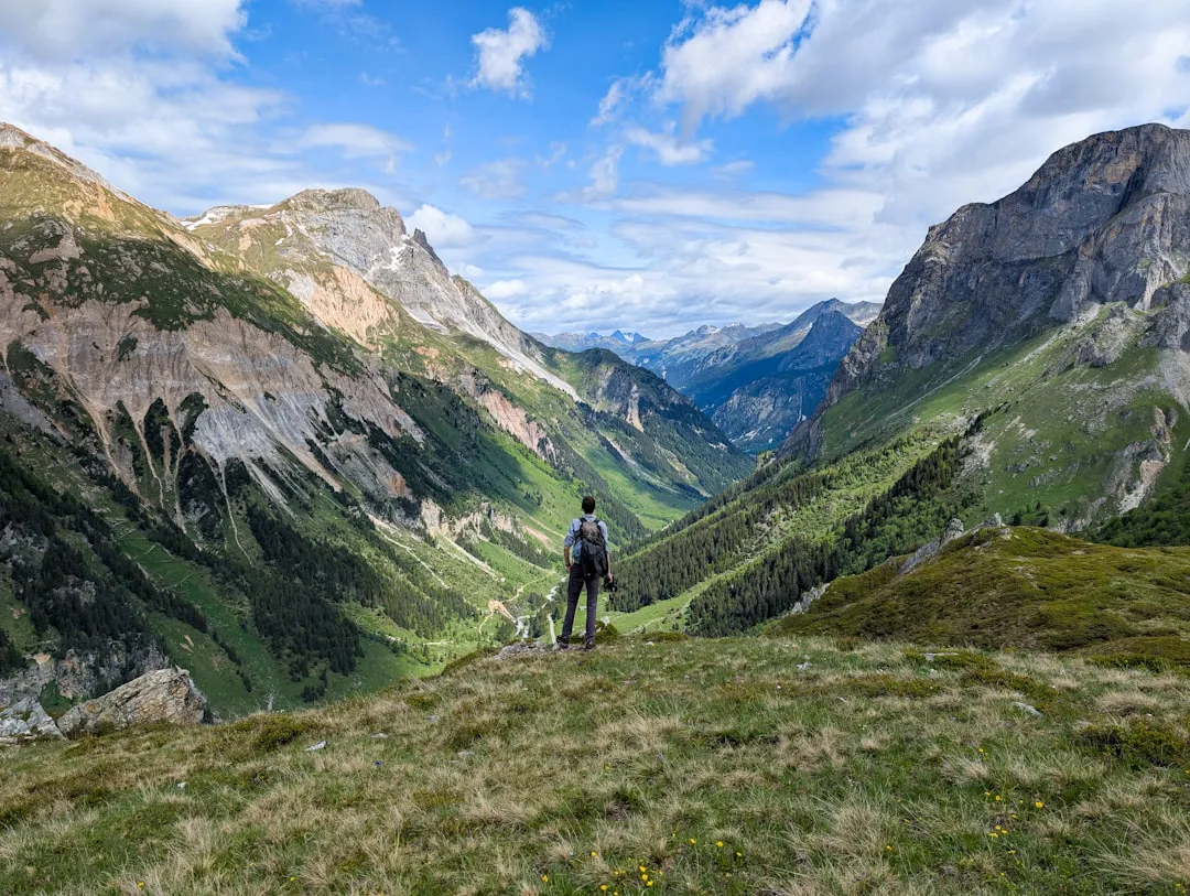
The Vanoise National Park Loop, often referred to as the Grand Tour de la Vanoise, is a premier high-altitude trekking experience located in the Savoie department of the French Alps. As France's first national park, established in 1963, the Vanoise offers a pristine sanctuary of glaciated peaks, turquoise alpine lakes, and vast mountain pastures. The loop typically covers approximately 110 kilometres, circumnavigating the massive ice caps of the Vanoise massif, including the Pelve and the Arsine glaciers. This journey is not merely a walk but a deep immersion into a landscape defined by its geological diversity—from the jagged limestone needles of the Dents de la Portetta to the dark, metamorphic schists of the high passes. Hikers traverse a world where the Alpine Ibex (Bouquetin) and Chamois roam freely, and where the traditional pastoral culture of the Savoie remains alive in the high summer alpages.
- Distance: 110.0 km (full loop)
- Duration: 7–9 days
- Elevation Gain: Approximately 7,000 m
- Difficulty: Challenging (high altitude, significant daily ascent)
- Highest Point: Col d'Aussois (2,914 m) or Pointe de l'Observatoire (3,015 m side trip)
- Best Time: Mid-June to mid-September
- Closest City: Chambéry, France
- Accommodation: High-altitude refuges (mountain huts)
Overview
The Vanoise National Park Loop is a masterclass in alpine scenery, offering a more secluded and rugged alternative to the famous Tour du Mont Blanc. While the latter is known for its international flair and constant views of the "Monarch of the Alps," the Vanoise provides a sense of profound wilderness and geological intimacy. The park is contiguous with Italy's Gran Paradiso National Park, together forming one of the largest protected areas in Western Europe. This trans-border connection allows for a flourishing ecosystem where wildlife populations are among the most stable in the Alps.
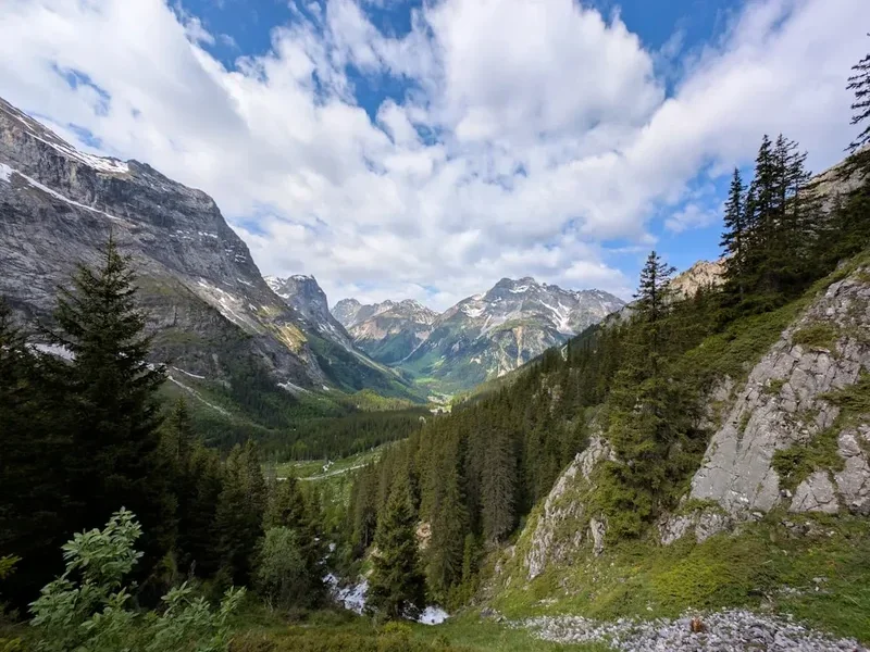
The terrain of the Vanoise is remarkably varied. The western side of the loop, near Pralognan-la-Vanoise, is characterised by dramatic limestone cliffs and the famous Lac des Vaches, where hikers cross a glacial lake on ancient stepping stones. As the trail moves east and south, the landscape transforms into vast, high-altitude plateaus and massive glacial tongues that spill down from peaks exceeding 3,500 metres, such as the Grande Casse (3,855 m). The route is physically demanding, requiring the crossing of several high passes (cols) each day, often involving steep scree slopes and occasional snow patches even in mid-summer.
Culturally, the loop is a journey through the history of the Savoie. The trail follows ancient "Salt Roads" used for centuries to transport salt from the mines of Moûtiers to Italy. Along the way, hikers encounter traditional stone-built hamlets and working dairy farms where the famous Beaufort and Tomme de Savoie cheeses are still produced using traditional methods. The network of refuges in the Vanoise is exceptional, ranging from historic stone shelters to modern, eco-friendly facilities, all providing the legendary "demi-pension" (half-board) service that makes trekking in the French Alps a culinary as well as a physical adventure.
History and Cultural Context
The creation of the Vanoise National Park in 1963 was a landmark moment for French conservation. It was established primarily to save the Alpine Ibex from extinction in France. At the time, the population had dwindled to a few dozen individuals. Today, thanks to the park's strict protections, thousands of ibex thrive within its borders, often seen perched on dizzying cliffs or grazing near the high passes. The park's emblem, the stylized horns of the ibex, is a constant reminder of this successful conservation effort.
Human history in the Vanoise is inextricably linked to the high-altitude passes. For millennia, these mountains were not barriers but corridors. The Col de la Vanoise (2,517 m) has been a transit route since the Bronze Age. In the 17th and 18th centuries, the "Route du Sel" (Salt Road) saw endless caravans of mules carrying "white gold" across the massif. This trade brought wealth to the valleys and led to the construction of the beautiful Baroque churches found in villages like Pralognan and Termignon. The architecture of the region—thick stone walls and heavy slate (lauze) roofs—reflects a long-standing adaptation to the harsh alpine winters.
During the Second World War, the rugged terrain of the Vanoise served as a stronghold for the French Resistance (the Maquis). The high refuges and hidden valleys provided sanctuary and strategic lookout points. Today, the park balances the preservation of this rich heritage with the demands of modern tourism, ensuring that the "montagnard" way of life continues to coexist with the protection of the natural environment.
Want more background? Read extended notes on history and cultural context → Learn more
Seasonal Highlights and Weather Reality
The hiking season in the Vanoise is strictly dictated by snowmelt and the opening dates of the mountain refuges. Most refuges open in mid-June and close by the third week of September. Outside of this window, the loop becomes a serious mountaineering or ski-touring undertaking, with high avalanche risk and extreme cold.
Early Summer (June to early July): This is the time of the great snowmelt. The valleys are vibrant green, and the alpine flowers—including the rare Soldanella and various orchids—are at their peak. However, many of the high passes, particularly the Col d'Aussois and Col de la Vanoise, will still have significant snow cover. Hikers during this period must be comfortable with snow travel and may require an ice axe or micro-spikes. The waterfalls are at their most thunderous during this time.
High Summer (July and August): This is the most popular time for the loop. The weather is generally stable, though afternoon thunderstorms are a common and serious occurrence. The high-altitude flora is spectacular, with Edelweiss and Gentians appearing in the rocky crevices. Wildlife is most active, and the marmots are frequently seen (and heard) in the alpine meadows. Refuges are often fully booked, so advanced planning is essential.
Late Summer (September): Many experienced trekkers consider September the best month for the Vanoise. The air is crisp and clear, providing the best visibility for photography. The crowds dissipate, and the autumn colours begin to tint the blueberries and grasses in shades of copper and gold. While the days are shorter and the nights are colder (often dropping below freezing at the higher refuges), the weather is typically more stable than in August.
Recommended Itinerary

9-Day Grand Tour de la Vanoise
Day 1: Pralognan-la-Vanoise to Refuge du Col de la Vanoise
- Distance: 8.5 km
- Elevation gain: 1,100 m
- Time: 4–5 hours
- Start in the village centre of Pralognan (1,410 m)
- Ascend through pine forests towards the Cirque de l'Arcelin
- Cross the famous Lac des Vaches via the ancient stone causeway
- Arrive at the Refuge du Col de la Vanoise (2,517 m), situated at the foot of the Grande Casse
- The afternoon can be spent watching for ibex on the surrounding scree slopes
Day 2: Refuge du Col de la Vanoise to Refuge d'Entre-Deux-Eaux
- Distance: 12 km
- Elevation loss: 500 m
- Time: 4 hours
- A relatively gentle day descending into the heart of the park
- Pass the Lac de la Loze and follow the Leisse river
- Spectacular views of the south face of the Grande Casse and the glaciers of the Vanoise
- Arrive at the historic Refuge d'Entre-Deux-Eaux (2,120 m), located at the confluence of two glacial torrents
- This area is a prime habitat for marmots and bearded vultures
Day 3: Refuge d'Entre-Deux-Eaux to Refuge de l'Arpont
- Distance: 14 km
- Elevation gain: 450 m
- Time: 5–6 hours
- Follow the "Sentier-Balcon" (balcony path) overlooking the Haute-Maurienne valley
- The trail winds through high-altitude moorland and rocky outcrops
- Constant views of the Dent Parrachée and the glaciers above
- Arrive at the modern Refuge de l'Arpont (2,309 m)
- The sunset views from the terrace across the valley to the Italian border peaks are world-class
Day 4: Refuge de l'Arpont to Refuge du Plan d'Amont
- Distance: 16 km
- Elevation gain: 600 m
- Time: 6–7 hours
- Continue along the balcony trail, crossing several glacial streams
- Pass through the ruins of ancient stone shepherd huts at Loza
- Descend slightly towards the turquoise reservoirs of Plan d'Amont and Plan d'Aval
- Arrive at Refuge du Plan d'Amont (2,200 m)
- This section is famous for its sightings of chamois in the early morning
Day 5: Refuge du Plan d'Amont to Refuge de l'Orgère
- Distance: 11 km
- Elevation gain: 400 m
- Time: 4–5 hours
- Ascend towards the Col de la Masse (optional detour) or follow the lower route through the Bois de l'Orgère
- The Bois de l'Orgère contains some of the oldest larch trees in Europe
- Arrive at the Refuge de l'Orgère (1,935 m), located in a beautiful forested bowl
- This is a lower-elevation stop, providing a bit of "thick air" and lush vegetation
Day 6: Refuge de l'Orgère to Refuge de Péclet-Polset
- Distance: 13 km
- Elevation gain: 1,000 m
- Time: 6 hours
- A challenging day involving the ascent of the Col de Chavière (2,796 m)
- The climb is steep and follows a series of tight switchbacks through a lunar landscape of schist
- From the col, enjoy views of the Mont Blanc massif to the north and the Ecrins to the south
- Descend to the Refuge de Péclet-Polset (2,474 m), a modern hut known for its excellent food
Day 7: Refuge de Péclet-Polset to Refuge du Roc de la Pêche
- Distance: 10 km
- Elevation loss: 550 m
- Time: 3–4 hours
- A shorter day descending the Vallon de la Rocheure
- Pass the Lac Blanc, which often holds ice well into July
- The trail follows a wide, easy track through high pastures
- Arrive at Refuge du Roc de la Pêche (1,911 m), which offers hotel-like comforts including hot showers and private rooms
Day 8: Refuge du Roc de la Pêche to Refuge de la Valette
- Distance: 12 km
- Elevation gain: 1,000 m
- Time: 6 hours
- A strenuous climb back into the high alpine zone
- Ascend the steep slopes of the Petit Mont Blanc (a gypsum mountain)
- The trail reaches the Refuge de la Valette (2,590 m), perched on a dramatic ridge
- This is the most spectacular hut location on the loop, overlooking the Pralognan valley
Day 9: Refuge de la Valette to Pralognan-la-Vanoise
- Distance: 9 km
- Elevation loss: 1,180 m
- Time: 4 hours
- A long, steep descent back to the trailhead
- Pass through the Pas de l'Ane and descend via the Cirque du Petit Marchet
- The trail winds through steep forest before emerging in the meadows above Pralognan
- Finish the loop in Pralognan-la-Vanoise for a celebratory meal
Planning and Bookings
Book Your Trip
Everything you need to plan your journey
Accommodation
Find places to stay near Chambéry
Flights
Search flights to Chambéry
Essential Preparation
The Vanoise National Park Loop is a high-altitude trek that requires a good level of physical fitness. You should be comfortable walking 6–8 hours a day with a 10–12 kg pack, involving daily ascents and descents of 800–1,000 metres. Training on hills or using a stair climber in the months leading up to the trip is highly recommended. Logistics are relatively straightforward: the main gateway is the village of Pralognan-la-Vanoise. The nearest major airport is Lyon (LYS) or Geneva (GVA). From there, take a train to Moûtiers-Salins-Brides-les-Bains, followed by a local bus (Altibus) to Pralognan. If driving, there is long-term parking available in Pralognan, though it can be busy in August.
Trail Accommodation
Accommodation on the loop is primarily in "refuges" (mountain huts). These are managed either by the Vanoise National Park authority or the Club Alpin Français (FFCAM). Most offer a "demi-pension" (half-board) option which includes dinner and breakfast. This is highly recommended as it significantly reduces your pack weight.
Hut Facilities:
- Dormitory-style sleeping (couchettes) with blankets and pillows provided
- Common dining areas where communal meals are served at set times (usually 7:00 PM)
- Basic washing facilities; hot showers are available at some huts for a small fee (usually 2–5 Euros)
- Drying rooms for wet gear and boots
- Small libraries and board games
- Electricity is usually solar-powered and limited; charging phones may not always be possible
What Refuges Don't Provide:
- Bed linen (a lightweight silk or cotton "sleep sack" is mandatory)
- Towels or toiletries
- Personal slippers (though most huts provide "crocs" or clogs for indoor use)
- Private rooms (except in a few lower-elevation lodges like Roc de la Pêche)
Booking Requirements:
- Bookings should be made several months in advance for July and August
- Most Vanoise refuges can be booked through a centralised online portal (vanoise-refuges.com)
- Costs: Approximately 55–70 Euros per night for half-board
- Cancellations usually require 48–72 hours' notice to receive a refund
Required Gear
- Hiking boots: Sturdy, waterproof, and well broken-in with good ankle support
- Backpack: 35–45 litres is sufficient if staying in refuges
- Waterproof layers: High-quality Gore-Tex jacket and overtrousers
- Insulation: A lightweight down or synthetic jacket and a fleece layer
- Trekking poles: Highly recommended for the steep descents to save your knees
- Navigation: Topographic maps (IGN 3534 OT and 3633 ET) and a compass or GPS
- Sun protection: High SPF sunscreen, lip balm, sunglasses (Category 3 or 4), and a sun hat
- First aid: Blister kits (Compeed), painkillers, and any personal medications
What to Bring
- Sleep sack: Silk or cotton liner for hut beds
- Water storage: At least 2 litres capacity (bladder or bottles)
- Water treatment: While hut water is usually potable, a small filter or tablets are useful for stream water
- Head torch: Essential for navigating dormitories at night and early starts
- Personal hygiene: Biodegradable soap, travel towel, and hand sanitiser
- Snacks: High-energy bars, nuts, and dried fruit (lunches can be purchased at refuges)
- Cash: Small denominations of Euros for drinks, showers, and snacks at huts (many don't take cards)
- Earplugs: Essential for sleeping in crowded dormitories
Permits
Unlike many North American or New Zealand parks, there is no "entry permit" required to hike in the Vanoise National Park. Access to the trail network is free. However, the "permit" system is effectively managed through the refuge booking system. Because wild camping (bivouacking) is strictly regulated and generally prohibited in the park's core zone, your ability to do the loop is dependent on securing bed nights in the refuges.
Refuge Booking Strategy:
- The booking season typically opens in January or February for the following summer.
- For the Grand Tour, you must book each hut individually or through the centralised Vanoise Refuges website.
- If a specific hut is full, look for "variante" routes that might lead to a different nearby refuge (e.g., Refuge de la Leisse instead of Entre-Deux-Eaux).
- Always carry a printed copy of your booking confirmations, as mobile signal is non-existent at many huts.
Bivouac Regulations:
- Bivouacking (setting up a small tent from sunset to sunrise) is only permitted in designated areas immediately adjacent to certain refuges during the summer season.
- A small fee (usually 5–10 Euros) is often charged for using these sites and the hut's facilities.
- Wild camping in the "Zone Coeur" (Core Zone) outside of these designated spots is strictly forbidden and carries heavy fines.
Other Activities in the Area
The Savoie region offers a wealth of activities for those looking to extend their stay before or after the trek:
- Via Ferrata: Pralognan-la-Vanoise is home to several world-class via ferrata routes, including the "Via Ferrata de la Fraîche," which features a dramatic waterfall crossing.
- Glacier Walking: Local guide offices (Bureau des Guides) offer guided day trips onto the Vanoise glaciers, providing an introduction to crampon and ice axe use.
- Cheese Tasting: Visit the Coopérative Laitière in Moûtiers or Bourg-Saint-Maurice to learn about Beaufort production and buy cheese directly from the source.
- Mountain Biking: The nearby Courchevel and Méribel valleys offer extensive lift-accessed mountain bike trails for all levels.
- Thermal Spas: After 9 days of hiking, the thermal baths at Brides-les-Bains offer the perfect recovery for tired muscles.
- Paragliding: Experience the Vanoise peaks from the air with a tandem flight from the slopes above Pralognan.
Safety and Conditions
Weather Awareness: The French Alps are prone to sudden and violent weather changes. Afternoon thunderstorms are common in July and August. These often bring lightning, hail, and a rapid drop in temperature. Hikers should aim to be over high passes and near their destination by early afternoon. Always check the "Météo France" mountain forecast (displayed at every refuge) before setting out.
Altitude and Terrain: Much of the loop stays above 2,000 metres. While altitude sickness is rare at these heights, the air is thinner, and dehydration occurs more quickly. The terrain is often rocky and unstable; scree slopes require careful foot placement. Early in the season, steep snow slopes can be dangerous without proper equipment and the knowledge of how to use it.
Wildlife and Livestock: While the ibex and chamois are generally shy, you may encounter large flocks of sheep or herds of cattle. These are often protected by "Patous" (Great Pyrenees livestock guardian dogs). If you encounter a Patou, do not try to pet it or run away. Walk slowly, keep your distance, and speak in a calm voice. Do not bring domestic dogs into the park's core zone, as they are strictly prohibited to protect wildlife.
Emergency Services: The emergency number in France is 112. However, mobile coverage is very spotty in the Vanoise. Refuges are equipped with radio or satellite phones for emergencies. It is highly recommended to have mountain rescue insurance (such as that provided by the Austrian Alpine Club or similar organisations).
Side Trips and Points of Interest
Pointe de l'Observatoire (3,015 m): This is the most popular "summit" side trip on the loop. Accessed from the Col de Chavière, it requires a short, easy scramble but rewards hikers with a 360-degree panorama that includes the Ecrins, the Vanoise glaciers, and a stunning view of Mont Blanc. It is one of the few 3,000-metre peaks in the region accessible to fit hikers without technical gear.
Lac des Vaches: Located on the ascent to the Col de la Vanoise, this shallow glacial lake is famous for its stepping stones. In the morning, the surrounding peaks are perfectly reflected in the still water, making it one of the most photographed spots in the French Alps.
The Monolith of Sardières: A 93-metre-high needle of cargneule rock standing alone in a larch forest near the Refuge de l'Orgère. It is a geological curiosity and a popular spot for rock climbers, but equally impressive to view from the hiking trail.
Petit Mont Blanc (2,677 m): Unlike its famous namesake, this mountain is made of white gypsum. The brilliant white rock creates a stark contrast with the surrounding green valleys and dark peaks. The summit offers an incredible perspective on the Pralognan valley and the glaciers of the Vanoise.
Leave No Trace
The Vanoise National Park is a fragile ecosystem. With over a million visitors annually, the "Leave No Trace" principles are not just suggestions; they are essential for the park's survival. The park's regulations are strictly enforced by rangers (gardes-moniteurs).
Specific Vanoise Rules:
- No Dogs: Domestic dogs are strictly prohibited in the Core Zone (Zone Coeur) of the park, even on a leash. This is to prevent the disturbance of wildlife and the spread of diseases to livestock.
- No Wild Camping: As mentioned, camping is only allowed in designated areas near refuges.
- Stay on Trails: The alpine tundra is extremely slow to recover. Walking off-trail causes erosion and destroys rare plant life.
- Waste Management: Pack out all rubbish. This includes organic waste like banana skins or orange peels, which decompose very slowly at high altitudes and can be harmful to local wildlife.
- Respect the Silence: Loud music or shouting is discouraged. The park is a sanctuary for both animals and people seeking solitude.
- No Picking Flowers: Many alpine plants are protected species. Take photos, not specimens.