
Vallée des Merveilles Trek - A Journey Through Time in the Mercantour
The Vallée des Merveilles Trek is one of Europe’s most extraordinary high-altitude experiences, located within the rugged heart of the Mercantour National Park in the French Maritime Alps. Spanning approximately 35 kilometres with a demanding 2,200 metres of elevation gain, this multi-day journey is far more than a physical challenge; it is a traverse through a prehistoric open-air museum. The valley is home to over 40,000 Bronze Age rock engravings, etched into the colourful schist and granite surfaces by shepherds and ancient peoples between 3,000 and 1,500 BC. Set against a backdrop of jagged peaks, glacial lakes, and the imposing presence of Mount Bégo—a peak once worshipped as a deity—the trek offers a profound connection to both the natural world and human history. Starting from the Lac des Mesches, the route climbs into a landscape of stark, mineral beauty where marmots, chamois, and ibex roam freely among the silent witnesses of our ancestral past.
- Distance: 35.0 km (loop or traverse options)
- Duration: 2–3 days
- Season: June to September (snow persists in May and October)
- Accommodation: Refuge des Merveilles, Refuge de Valmasque (booking essential)
- Highest point: Baisse de la Valmasque (2,549 m)
- Difficulty: Challenging (steep ascents, rocky terrain, high-altitude environment)
- Closest City: Nice, France
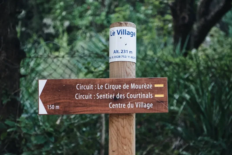
- Trailhead: Lac des Mesches (accessible via the Train des Merveilles and bus)
Overview
The Vallée des Merveilles (Valley of Wonders) is a landscape defined by its dramatic geology and its status as a sacred site for the ancient inhabitants of the Mediterranean basin. Located in the south-eastern corner of France, near the Italian border, the trek takes hikers through a high-alpine environment where the Mediterranean climate meets the harsh realities of the Alps. The terrain is characterised by "moutonné" rocks—smooth, glacier-polished surfaces of green and orange-red schist—which provided the perfect canvas for the prehistoric engravings that give the valley its name. The trek typically begins at the Lac des Mesches (1,370 m) and ascends through the Vallon de la Minière, gradually leaving the larch forests behind for a world of rock, water, and sky.
The primary draw of the trek is the concentration of petroglyphs found in the "Zone Réglementée" (Restricted Zone). These engravings depict a variety of motifs, including horned figures (bovids), daggers, halberds, and complex geometric patterns known as "topographical" figures. To see the most famous engravings, such as "The Sorcerer" or "The Chief of the Tribe," hikers must either stay on the designated GR (Grande Randonnée) paths or hire a certified mountain guide to venture into the restricted archaeological areas. This preservation effort ensures that the fragile engravings, weathered by millennia of alpine winters, remain protected for future generations.
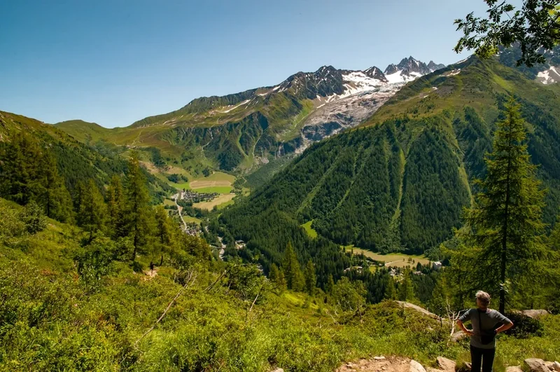
Beyond the archaeology, the trek is a masterclass in alpine scenery. The route circles Mount Bégo (2,872 m), passing a series of stunning glacial lakes including Lac Long Supérieur, Lac Fourca, and the Lacs de la Valmasque. The ascent to the Baisse de la Valmasque (2,549 m) provides a breathtaking panorama of the surrounding Mercantour peaks and, on exceptionally clear days, glimpses of the Mediterranean Sea to the south. The physical demand is significant, with steep, rocky switchbacks and sections of loose scree, but the reward is an unparalleled sense of solitude and historical immersion in one of France's most protected wilderness areas.
History and Cultural Context
The history of the Vallée des Merveilles is inextricably linked to the spiritual lives of the Bronze Age peoples who inhabited the lower valleys. For these early pastoralists, Mount Bégo was a sacred mountain, believed to be the home of a powerful storm god who controlled the rain and the fertility of the land. The thousands of engravings found around the base of the mountain were likely offerings or petitions to this deity. The horned figures, which make up the majority of the engravings, represent bulls—symbols of strength and agricultural prosperity. The daggers and halberds reflect the emergence of metalworking and the social status of the warriors and leaders of the time.
While the engravings were known to local shepherds for centuries—who often added their own "graffiti" or crosses to ward off what they perceived as pagan spirits—they did not receive scientific attention until the late 19th century. The most significant figure in the modern history of the valley is Clarence Bicknell, a British amateur naturalist and former clergyman. Between 1897 and 1912, Bicknell spent his summers in the valley, meticulously documenting, rubbing, and photographing thousands of engravings. His work, "A Guide to the Prehistoric Rock Engravings of the Italian Maritime Alps," brought the site to international prominence and remains a foundational text for archaeologists today.
In 1979, the Mercantour National Park was established, and the Vallée des Merveilles was designated as a National Historic Monument. This status brought strict regulations to protect the site from erosion and vandalism. Today, the valley is managed by the Parc National du Mercantour in collaboration with the Musée des Merveilles in Tende. The cultural significance of the area continues to evolve, as modern visitors find their own sense of wonder in the connection between the ancient symbols and the timeless alpine landscape. The land remains a place of deep silence, where the only sounds are the whistling of marmots and the occasional thunderclap—a reminder of the storm god that once commanded the devotion of an entire civilisation.
Want more background? Read extended notes on history and cultural context → Learn more
Seasonal Highlights and Weather Reality
The trekking season in the Vallée des Merveilles is relatively short due to its high altitude and the persistence of snow on the mountain passes. The window for hiking typically opens in mid-June and closes by late September or early October. Outside of this period, the trail becomes a technical mountaineering route requiring ice axes, crampons, and advanced navigation skills.
Summer (July and August): This is the peak season for the trek. The weather is generally stable, with warm days and cool nights. The alpine wildflowers, including the rare Saxifraga florulenta (the emblem of the Mercantour), are in full bloom. However, this is also the season of the famous Mercantour afternoon thunderstorms. Due to the high iron content in the rocks, the valley is a natural lightning conductor. Hikers should aim to cross the high passes (like Baisse de la Valmasque) before midday to avoid being caught in a storm.
Shoulder Season (June and September): June is a beautiful time to visit, as the lakes are often still partially frozen and the snow patches provide a dramatic contrast against the red rocks. However, the Baisse de la Valmasque may still be blocked by snow, requiring detours or technical gear. September offers the most stable weather and crisp, clear air, with the added benefit of fewer crowds. The larch trees begin to turn gold towards the end of the month, creating a spectacular autumnal display.
Winter and Spring (November to May): The valley is buried under deep snow, and the refuges are closed (though winter shelters may be available). Avalanche risk is high on the steep slopes surrounding the valley. This period is only suitable for experienced ski tourers or snowshoers with full avalanche safety equipment and knowledge of the terrain.
Recommended Itinerary
3-Day Vallée des Merveilles Traverse
Day 1: Lac des Mesches to Refuge des Merveilles
- Distance: 10 km
- Elevation gain: 750 m
- Time: 4–5 hours
- Start at the Lac des Mesches parking area (1,370 m)
- Follow the wide track through the Vallon de la Minière, shaded by ancient larch and pine trees
- Pass the small hamlet of Minière de Vallauria, an old mining site
- The trail steepens as you enter the heart of the Mercantour National Park
- Arrive at the Refuge des Merveilles (2,111 m), situated on the shores of Lac Long Supérieur
- Afternoon: Take a short walk around the lake to see the first accessible engravings near the refuge
- Evening: Enjoy a communal meal at the refuge and watch the sunset over the jagged peaks of the Grand Capelet
Day 2: Refuge des Merveilles to Refuge de Valmasque via Baisse de la Valmasque
- Distance: 12 km
- Elevation: 450 m gain, 350 m descent
- Time: 6–7 hours (including engraving exploration)
- Morning: Join a guided tour (highly recommended) to see the restricted engravings like "The Sorcerer" and "The Chief of the Tribe"
- The route follows the GR52, climbing through a lunar landscape of polished schist and glacial tarns
- Ascend the steep switchbacks to the Baisse de la Valmasque (2,549 m), the highest point of the trek
- Take in the panoramic views of the Valmasque lakes to the north and the Merveilles valley to the south
- Descend into the Valmasque valley, passing Lac Noir and Lac du Raté
- Arrive at the Refuge de Valmasque (2,233 m), perched above the stunning Lac Vert
- This is the most physically demanding day but offers the greatest rewards in terms of scenery and history
Day 3: Refuge de Valmasque to Lac des Mesches via Casterino
- Distance: 13 km
- Elevation: 100 m gain, 950 m descent
- Time: 5–6 hours
- Descend from the refuge along the shores of Lac Vert and Lac Fourca
- Follow the Valmasque torrent down a dramatic glacial valley
- The trail enters the forest as you approach the Nordic skiing centre of Casterino (1,550 m)
- Stop for lunch in Casterino, a charming mountain village known for its local cheeses and honey
- Follow the forest trail (Sentier de la Minière) back towards the Lac des Mesches
- Final descent back to the trailhead to complete the loop
- Optional: Visit the Musée des Merveilles in the nearby town of Tende to see original engravings and learn more about the site's archaeology
Important Notes:
- Refuge bookings are mandatory and should be made months in advance for July and August
- Walking sticks must have rubber tips to protect the rocks and engravings
- No wild camping is permitted within the central zone of the National Park
- Water is available at refuges, but treatment is recommended for stream water
- The "Train des Merveilles" from Nice to Saint-Dalmas-de-Tende is a scenic highlight of the trip
Planning and Bookings
Book Your Trip
Everything you need to plan your journey
Accommodation
Find places to stay near Nice
Flights
Search flights to Nice
Essential Preparation
The Vallée des Merveilles is a high-altitude trek that requires a good level of physical fitness and mountain experience. While the trails are generally well-marked (GR52), the terrain is rocky and can be punishing on the knees. Preparation should begin with cardiovascular training and hiking on uneven terrain. Logistics are centered around the city of Nice, which serves as the primary gateway. From Nice, the "Train des Merveilles" provides a spectacular rail journey into the Roya Valley. You will need to disembark at Saint-Dalmas-de-Tende and take a pre-booked shuttle or taxi to the Lac des Mesches trailhead. Coordination between train times and trail starts is crucial, as mountain transport can be infrequent.
Before departing, ensure you have downloaded offline maps (IGN maps are the gold standard in France) and checked the latest weather reports from Météo-France. It is also advisable to spend a night in Nice or the mountain village of Tende to acclimatise and ensure you are ready for an early start on Day 1.
Trail Accommodation
Accommodation on the trek is provided by the Club Alpin Français (CAF) refuges. These are high-mountain huts that offer a unique communal experience but require adherence to specific mountain etiquette.
Refuge des Merveilles (2,111 m): Located in the heart of the valley, this refuge has 80 berths in dormitory-style rooms. It provides half-board (dinner, bed, and breakfast) and packed lunches upon request. Facilities include shared toilets, cold water sinks, and limited solar-powered lighting. Hot showers may be available for a small fee depending on water levels.
Refuge de Valmasque (2,233 m): Situated above Lac Vert, this refuge is smaller and more intimate, with 50 berths. It offers a similar level of service to the Merveilles refuge. The setting is spectacular, surrounded by high peaks and alpine lakes.
Booking Requirements: Bookings must be made through the FFCAM (Fédération Française des Clubs Alpins et de Montagne) website. During the peak months of July and August, these refuges sell out quickly. Costs are approximately €50–€60 per night for half-board. Note that wild camping (bivouacking) is strictly regulated: it is only allowed between 7:00 PM and 9:00 AM and must be at least an hour's walk from the park boundaries or road access.
Required Gear
- Hiking boots: Sturdy, waterproof boots with good ankle support and a Vibram-style sole for grip on wet schist.
- Backpack: A 35–45 litre pack is sufficient for a 3-day trek with refuge stays. Ensure it has a waterproof rain cover.
- Clothing layers: A moisture-wicking base layer, a fleece or down mid-layer, and a high-quality waterproof/breathable shell (Gore-Tex or similar).
- Walking sticks: Essential for the steep descents, but they MUST have rubber tips (embouts) to avoid scratching the rocks.
- Navigation: Topographic map (IGN 3741OT), compass, and a GPS or smartphone with offline maps (e.g., Gaia GPS or AllTrails).
- Headlamp: Essential for refuge life and in case of late arrivals. Bring spare batteries.
- First aid kit: Include blister plasters (Compeed), antiseptic wipes, pain relief, and any personal medications.
- Sun protection: High SPF sunscreen, lip balm with UV protection, sunglasses (Category 3 or 4), and a wide-brimmed hat.
What to Bring
- Sleeping bag liner: Mandatory for hygiene in CAF refuges (blankets and pillows are provided, but you must use your own liner/silk bag).
- Water filtration: A Katadyn BeFree or LifeStraw is useful for refilling from streams, though refuge water is generally potable.
- Food and snacks: High-energy snacks (nuts, dried fruit, chocolate) for the trail. Refuges provide dinner and breakfast, but you should carry lunch for Day 1.
- Toiletries: Biodegradable soap, travel towel, toothbrush, and toothpaste. Keep it minimal to save weight.
- Earplugs: Highly recommended for sleeping in communal dormitories.
- Cash: Many refuges do not accept credit cards or have unreliable connections; bring enough Euros for drinks, lunches, and showers.
- Power bank: To keep your phone/GPS charged, as power outlets in refuges are extremely limited or non-existent.
Permits
No individual permits are required to hike the GR52 or the main trails through the Vallée des Merveilles. However, the area is a protected archaeological site, and strict regulations apply to the "Zone Réglementée" (Restricted Zone). Within this zone, you are strictly forbidden from leaving the marked trails unless accompanied by a certified mountain guide (Accompagnateur en Moyenne Montagne) with a specific "Merveilles" accreditation.
Guided Tours: To see the most significant engravings, such as the "Sorcier" (Sorcerer), you must book a guided tour. These are organised daily during the summer by the Bureau des Guides du Mercantour. Tours typically depart from the Refuge des Merveilles or the Lac des Mesches. The cost is approximately €25–€35 per person. Booking in advance is highly recommended, especially for English-speaking tours.
National Park Rules: The Mercantour National Park has strict "Core Zone" regulations. It is prohibited to:
- Touch the engravings or walk on the engraved rock surfaces.
- Use walking sticks without rubber tips.
- Take any rocks, plants, or fossils from the park.
- Bring dogs, even on a leash (to protect wildlife like ibex and chamois).
- Light fires or discard any waste (including organic waste).
- Fly drones without a specific professional permit.
Other Activities in the Area
The Roya Valley and the surrounding Mercantour region offer a wealth of activities for those looking to extend their stay:
- Musée des Merveilles (Tende): An essential visit before or after your trek. This modern museum houses original engravings moved for preservation, life-sized casts, and detailed exhibits on the Bronze Age culture of the Alps.
- The Village of Tende: Explore the narrow, medieval streets of this historic border town. Visit the Collégiale Notre-Dame-de-l'Assomption with its striking Renaissance portal and the ruins of the Lascaris Castle.
- Canyoning in the Roya Valley: The valley is world-renowned for its canyoning. The "Clue d'Aiglun" and "Maglia" canyons offer emerald pools, natural slides, and dramatic abseils for adventure seekers.
- Via Ferrata: Tende and nearby La Brigue offer spectacular via ferrata routes, including the "Via Ferrata des Comtes de Lascaris," which provides bird's-eye views of the village.
- Train des Merveilles: Even if not used for transport, the rail journey from Nice to Tende is an activity in itself, featuring loops, tunnels, and viaducts that are masterpieces of early 20th-century engineering.
- Saorge: Visit this "acropolis" village, perched precariously on a cliffside. The Franciscan Monastery (Monastère de Saorge) is a peaceful retreat with beautiful baroque architecture and gardens.
Safety and Conditions
Weather and Lightning: The most significant safety hazard in the Vallée des Merveilles is the weather. Afternoon thunderstorms are frequent and violent. Because the rocks have a high iron content, the valley is particularly prone to lightning strikes. If you hear thunder or see dark clouds building, descend from high ridges and passes immediately. Avoid standing near isolated trees or large metal objects (like trail signs).
Terrain: The trail involves significant elevation changes and rocky, uneven surfaces. Ankle sprains are the most common injury. Ensure your boots are well broken-in and provide adequate support. In early summer (June), snow patches on the Baisse de la Valmasque can be icy and dangerous; trekking poles and traction devices (like micro-spikes) may be necessary.
Navigation: While the GR52 is well-marked with red and white blazes, fog can descend rapidly, reducing visibility to a few metres. Always carry a physical map and compass, and know how to use them. Do not rely solely on a smartphone, as cold temperatures and GPS usage can drain batteries quickly.
Wildlife: While ibex and chamois are generally docile, they are wild animals and should be given plenty of space. Marmots are common and may approach looking for food—never feed them, as it disrupts their natural diet and hibernation preparation. The region is also home to the Italian wolf; while sightings are rare and they pose no threat to humans, their presence is a reminder of the wild nature of the Mercantour.
Emergency Services: In case of an emergency, the European emergency number is 112. Note that mobile signal is non-existent in most of the valley. Refuges are equipped with radio systems to contact mountain rescue (PGHM - Peloton de Gendarmerie de Haute Montagne).
Side Trips and Points of Interest
Mount Bégo Summit (2,872 m): For fit hikers, the ascent of Mount Bégo offers the ultimate perspective on the valley. The climb is steep and involves some light scrambling, but the 360-degree view encompasses the entire Mercantour, the Italian Alps, and the Mediterranean. This was the "Sacred Mountain" of the Bronze Age, and standing on its summit provides a powerful connection to the ancient worshippers.
The "Sorcier" (The Sorcerer) Engraving: Located in a restricted area of the Vallee des Merveilles, this is perhaps the most famous petroglyph in the Alps. It depicts a figure with upraised arms and a head surrounded by zig-zags, often interpreted as a shaman or a deity. Access is only possible via a guided tour, but it is the highlight of the archaeological experience.
The "Chef de Tribu" (Chief of the Tribe): Another iconic engraving, this figure features a large, rectangular body and a complex headpiece. It is located near the main trail but is best viewed with a guide who can point out the subtle details and explain the current archaeological theories regarding its meaning.
Lacs de la Valmasque: The trio of lakes—Lac Vert, Lac Noir, and Lac du Raté—are among the most beautiful in the French Alps. The contrast between the deep blue water and the stark, grey granite peaks is stunning. The area around the Refuge de Valmasque is also one of the best places in the park to spot large herds of ibex, especially in the early morning or late evening.
The "Christ" Engraving: A fascinating example of how the valley's history continued into the Christian era. This engraving, located near the GR52, shows a figure that was modified by later visitors to resemble a crucifix, demonstrating the long-standing human impulse to leave a mark on these sacred rocks.
Leave No Trace
The Vallée des Merveilles is a fragile ecosystem and a priceless archaeological site. The "Leave No Trace" principles are not just guidelines here; they are strictly enforced by law. The preservation of the 4,000-year-old engravings depends entirely on the respect of visitors.
Protecting the Engravings: The oils from human skin can accelerate the erosion of the rock surfaces. Never touch the engravings. Walking on engraved surfaces is strictly prohibited. Ensure your walking sticks have rubber tips at all times to prevent accidental scratching of the schist.
Waste Management: There are no rubbish bins on the trail or at the refuges. You must pack out everything you bring in, including fruit peels and nut shells, which decompose very slowly in the cold, high-altitude environment. Use the toilets at the refuges whenever possible. If you must go on the trail, ensure you are at least 50 metres from water sources and bury waste in a "cathole" 15 cm deep.
Respecting Wildlife: The Mercantour is a sanctuary for species that are rare elsewhere in Europe. Observe animals from a distance and never attempt to follow or corner them. Keep noise levels low to avoid disturbing the silence that is a key part of the wilderness experience.
Water Protection: Do not use soap or detergent in the alpine lakes or streams. Even biodegradable soap can harm the delicate aquatic life in these nutrient-poor environments. If you need to wash, carry water 30 metres away from the source and use a minimal amount of biodegradable soap.