Vale das Borboletas Trail
The Vale das Borboletas Trail, translating to "Valley of Butterflies," is a captivating day walk nestled within the Serra da Canastra National Park in Brazil. This trail offers a moderate challenge with significant elevation gain, rewarding hikers with breathtaking panoramic views and a deep immersion into the unique Cerrado biome. Known for its diverse flora and fauna, the valley is a haven for various butterfly species, especially during the wetter months, lending the trail its evocative name. The journey traverses varied terrain, from open grasslands to rocky outcrops and dense pockets of Atlantic Forest remnants, providing a rich ecological experience. While accessible as a day hike, its remoteness and the need for careful planning make it a destination for those seeking an authentic wilderness adventure away from the usual tourist trails.
- Category: Day Walk
- Distance: 12.0 km one-way
- Elevation Gain: 600 m
- Duration: 4–6 hours
- Difficulty: Moderate
- Best Time: April to September (dry season)
- Closest City: São Roque de Minas
- Trailhead Access: Requires 4x4 vehicle due to rough dirt roads; limited parking
- Permits: Not required
Overview
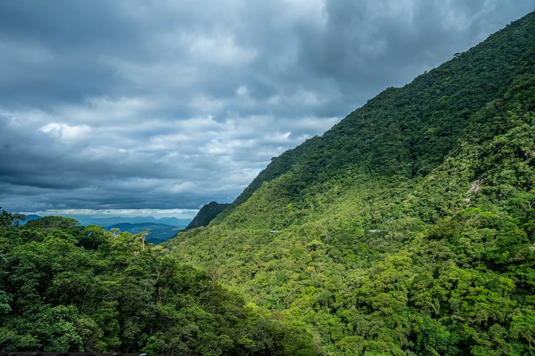
The Vale das Borboletas Trail is a gem for nature enthusiasts and hikers looking for a substantial day walk in Brazil's Minas Gerais state. Its moderate difficulty is primarily due to the consistent elevation gain of 600 metres over 12 kilometres, demanding a reasonable level of fitness. The trail begins at a relatively low elevation and steadily climbs, offering progressively wider vistas as you ascend. The landscape is a vibrant tapestry of the Cerrado, Brazil's vast tropical savanna ecoregion, characterised by its unique plant life adapted to seasonal fires and dry conditions, interspersed with patches of humid Atlantic Forest. This ecological diversity supports a rich array of wildlife, including numerous bird species, small mammals, and, as the name suggests, a spectacular variety of butterflies, particularly during the warmer, wetter periods.
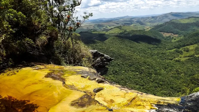
The trail's progression is marked by distinct ecological zones. Initially, you might walk through open grasslands dotted with characteristic Cerrado shrubs and trees like the _pequi_ (_Caryocar brasiliense_) and _ipê_ (_Handroanthus spp._). As you gain altitude, the vegetation may transition, with more resilient flora clinging to rocky outcrops. The final ascent often leads through or alongside remnants of Atlantic Forest, a highly biodiverse biome that once covered much of Brazil's coast. The summit offers commanding views over the surrounding Serra da Canastra region, a vast plateau known for its waterfalls, springs, and unique geological formations. The descent retraces your steps, allowing for a different perspective on the landscape and an opportunity to spot flora and fauna missed on the way up.
The trail is best experienced during the dry season (April to September) when the weather is more predictable, and the risk of heavy rainfall, which can make the dirt access roads impassable, is significantly reduced. Even during the dry season, however, Fiordland's weather can be unpredictable, so carrying appropriate gear for changing conditions is essential. The Vale das Borboletas Trail is not a heavily trafficked route, offering a sense of solitude and a genuine connection with nature, making it a rewarding experience for those who undertake the journey.
History and Cultural Context
The Serra da Canastra region, where the Vale das Borboletas Trail is located, has a rich history intertwined with Brazil's exploration and development. Historically, this area was part of indigenous territories before Portuguese colonisation. The region's plateaus and valleys provided resources and routes for various indigenous groups. Over centuries, the area became known for its natural wealth, particularly its water sources, which are crucial for many of Brazil's major river systems, including the São Francisco River, often called the "River of National Integration."
The establishment of the Serra da Canastra National Park in 1972 was a significant step towards preserving this unique ecosystem. The park was created to protect the headwaters of the São Francisco River and the diverse Cerrado and Atlantic Forest habitats found within its boundaries. The Vale das Borboletas Trail, while not a historical route of major indigenous migration or colonial trade in the same vein as some other South American trails, represents a path through a landscape that has been shaped by natural forces and, more recently, by conservation efforts.
The name "Vale das Borboletas" itself speaks to the natural heritage of the area. The abundance of butterflies is a testament to the health and diversity of the local flora, which provides nectar and host plants for these insects. The trail's existence as a designated hiking route within the national park highlights a growing appreciation for ecotourism and the importance of preserving these natural landscapes for both scientific study and recreational enjoyment. The local communities surrounding São Roque de Minas have a long history of agriculture and cattle ranching, and the park's establishment has influenced land use and conservation awareness in the region.
Seasonal Highlights and Weather Reality
The Vale das Borboletas Trail experiences distinct wet and dry seasons, significantly impacting the hiking experience and the surrounding environment.
Dry Season (April to September): This is the optimal period for hiking the Vale das Borboletas Trail. The weather is generally sunny and pleasant, with lower humidity and minimal rainfall. Temperatures are moderate, typically ranging from 15°C to 25°C. The dry conditions make the access roads to the trailhead more manageable, reducing the risk of getting stuck. While the landscape might appear drier, the trail remains accessible, and the clear skies offer excellent visibility for the panoramic views from the higher elevations. Butterfly activity may be less prolific than in the wet season, but many species are still present, and the overall hiking conditions are superior.
Wet Season (October to March): This period is characterised by heavy rainfall, high humidity, and thunderstorms, often occurring in the afternoon. Temperatures can be warmer, ranging from 20°C to 30°C. The abundant rainfall transforms the landscape, making it lush and green. Waterfalls and streams are at their most impressive, and the abundance of nectar-producing flowers attracts a significantly higher number of butterflies, truly living up to the "Valley of Butterflies" name. However, the wet season presents considerable challenges for hikers. The dirt access roads can become extremely muddy and impassable, even for 4x4 vehicles, potentially leading to the trail being inaccessible. Hiking on the trail itself can be more strenuous due to slippery conditions, and the risk of flash floods in lower-lying areas increases. Thunderstorms can be sudden and severe, posing a safety risk.
Shoulder Seasons (March/April and September/October): These transitional periods can offer a mix of conditions. You might experience some lingering rain from the wet season or the beginnings of the dry season's clear skies. Butterfly activity can still be high in early October. These months can be a good compromise if you wish to see more active butterflies while still benefiting from somewhat more stable weather than the peak wet season.
Recommended Itinerary
Vale das Borboletas Trail - Day Hike Itinerary
Early Morning (Approx. 7:00 AM - 8:00 AM): Departure from São Roque de Minas
- Begin your journey from São Roque de Minas.
- Ensure your 4x4 vehicle is prepared for rough terrain.
- Pack all necessary supplies: water, food, first-aid kit, sun protection, and rain gear.
- The drive to the trailhead can take 1-2 hours depending on road conditions.
Morning (Approx. 9:00 AM - 10:00 AM): Arrival at Trailhead and Start of Hike
- Reach the designated trailhead. Note that parking is limited and informal.
- Take a moment to orient yourself, check your gear, and begin the ascent.
- The initial section of the trail is often through open Cerrado grasslands, with a steady incline.
- Observe the unique vegetation adapted to this biome.
Late Morning (Approx. 10:00 AM - 12:00 PM): Ascending Through Varied Terrain
- The trail continues its climb, potentially transitioning into areas with more rocky terrain or denser vegetation.
- Keep an eye out for local wildlife, including various bird species and, of course, butterflies.
- The elevation gain becomes more pronounced, offering increasingly expansive views of the surrounding landscape.
- This is a good time to take short breaks for water and snacks.
Midday (Approx. 12:00 PM - 1:30 PM): Reaching Higher Elevations and Potential Lunch Spot
- You will be at a significant elevation gain by this point.
- Find a suitable, safe spot for a rest and a packed lunch, enjoying the panoramic vistas.
- The air may feel cooler at these altitudes.
- Continue to observe the changing flora and fauna as you approach the higher points of the trail.
Afternoon (Approx. 1:30 PM - 3:00 PM): Summit Views and Beginning Descent
- Reach the highest accessible points of the trail, offering the most spectacular 360-degree views of the Serra da Canastra region.
- Spend time appreciating the vastness of the landscape.
- Begin your descent, retracing your steps back towards the trailhead.
- The descent can be as challenging as the ascent, requiring careful footing on loose or slippery surfaces.
Late Afternoon (Approx. 3:00 PM - 5:00 PM): Return to Trailhead and Departure
- Arrive back at the trailhead.
- Ensure all your belongings are accounted for and the area is left clean.
- Begin the drive back to São Roque de Minas.
- The journey back may offer different light conditions for photography.
Important Notes:
- This is a day hike; no overnight accommodation is required.
- The trail is not formally marked in all sections; navigation skills or a guide are recommended.
- Carry sufficient water (at least 2-3 litres per person) as there are no reliable water sources on the trail.
- Sun protection (hat, sunscreen, sunglasses) is crucial due to high exposure.
- Wear sturdy, broken-in hiking boots with good ankle support.
- Be prepared for sudden weather changes, even in the dry season.
Planning and Bookings
Book Your Trip
Everything you need to plan your journey
Accommodation
Find places to stay near Abisko
Flights
Search flights to Abisko
Essential Preparation
The Vale das Borboletas Trail is located in a relatively remote area, requiring thorough preparation. São Roque de Minas is the closest town and serves as the primary base for accessing the Serra da Canastra National Park. It offers basic amenities, including guesthouses (_pousadas_), restaurants, and small shops. It is advisable to stock up on all necessary supplies, including food, water, and any specific gear, in larger cities like Belo Horizonte or Passos before arriving in São Roque de Minas, as options are limited locally.
Vehicle Access: A significant aspect of planning is the access to the trailhead. The dirt roads leading to the Vale das Borboletas Trail are often rough, unpaved, and can be challenging, especially after rain. A 4x4 vehicle is highly recommended, and in some conditions, may be essential. If you do not have a suitable vehicle, consider hiring a local guide who will have appropriate transport and knowledge of the road conditions. Check local weather forecasts and road status before setting out.
Guides: While the trail is technically a day hike, it is not always well-marked. Hiring a local guide is strongly recommended, especially for first-time visitors. Guides provide invaluable knowledge of the terrain, flora, and fauna, enhance safety, and can assist with navigation. They can also advise on the best times to visit for butterfly sightings and ensure you have the most appropriate vehicle for access.
Trail Accommodation
This is a day hike requiring no overnight accommodation.
Required Gear
- Hiking Boots: Sturdy, waterproof hiking boots with good ankle support are essential. Ensure they are well broken-in to prevent blisters.
- Backpack: A comfortable daypack (20-30 litres) to carry essentials.
- Navigation: A reliable GPS device or smartphone with offline maps of the area is highly recommended, as trail markings can be inconsistent. A compass and map are also advisable.
- Sun Protection: Wide-brimmed hat, sunglasses, and high SPF sunscreen are crucial due to the exposed nature of the trail and the intensity of the sun at higher altitudes.
- Rain Gear: A lightweight, waterproof and windproof jacket is essential, even in the dry season, as weather can change rapidly in mountainous regions.
- First-Aid Kit: A comprehensive kit including bandages, antiseptic wipes, pain relievers, blister treatment, and any personal medications.
- Insect Repellent: While sandflies are not the primary concern here, mosquitoes and other biting insects can be present, especially near water sources or during warmer periods.
What to Bring
- Food: High-energy snacks and a packed lunch. There are no facilities for purchasing food along the trail or at the trailhead.
- Water: Carry at least 2-3 litres of water per person. There are no reliable water sources on the trail for purification.
- Toiletries: Biodegradable soap, hand sanitiser, and toilet paper. Pack out all waste.
- Personal Items: Camera, binoculars (for wildlife viewing), power bank for electronic devices.
- Clothing Layers: Lightweight, moisture-wicking base layers, an insulating mid-layer (fleece or down jacket), and your waterproof outer shell.
- Trekking Poles: Optional, but can be helpful for stability on ascents and descents, especially on uneven terrain.
Permits
The Vale das Borboletas Trail is located within the Serra da Canastra National Park. While the park itself requires no specific entry permits for day hikers, it is important to be aware of park regulations and any potential fees that may be implemented by ICMBio (Instituto Chico Mendes de Conservação da Biodiversidade), the federal agency responsible for managing Brazil's protected areas. Currently, for day hikes on trails like Vale das Borboletas, no advance booking or specific permit is typically required for independent hikers.
However, it is always advisable to check the official ICMBio website or contact the park's visitor centre in São Roque de Minas for the most up-to-date information regarding access, any potential fees, or specific regulations before your visit. The park's management can change, and staying informed ensures a smooth and compliant visit.
Key Considerations:
- Park Entrance: While no specific permit is usually needed for this trail, be aware that other areas within the national park might have different access requirements or fees.
- Guides: If you opt for a guided tour, the guide will typically handle any necessary arrangements or fees related to park access or specific trail usage.
- Road Conditions: The primary challenge is not obtaining a permit but rather the access road. Ensure your vehicle is suitable and that you are prepared for potentially rough driving conditions.
- Respect for Nature: Adherence to Leave No Trace principles is paramount, as this is a protected natural area.
Other Activities in the Area
The Serra da Canastra region offers a variety of activities beyond the Vale das Borboletas Trail, making it a worthwhile destination for a longer stay:
- São Francisco River Headwaters: Visit the source of the mighty São Francisco River, a significant landmark within the national park. This is a place of natural beauty and cultural importance.
- Casca D'Anta Waterfall: Explore the impressive Casca D'Anta waterfall, one of the park's most famous attractions. It has two sections: the upper fall, accessible by road, and the lower fall, which requires a hike.
- Wildlife Spotting: The park is home to diverse wildlife, including the endangered maned wolf (_Chrysocyon brachyurus_), giant anteaters (_Myrmecophaga tridactyla_), _capybaras_, and numerous bird species. Early mornings and late afternoons are often the best times for sightings.
- Exploring São Roque de Minas: This charming town offers a glimpse into rural Brazilian life. Enjoy local cuisine, visit artisanal cheese producers (Minas cheese is famous), and experience the relaxed pace of life.
- Other Hiking Trails: The national park contains numerous other trails and routes, varying in difficulty and length, offering further opportunities to explore the Cerrado and Atlantic Forest ecosystems.
- Photography: The dramatic landscapes, unique flora, abundant fauna, and stunning waterfalls provide ample opportunities for landscape and wildlife photography.
Safety and Conditions
Trail Conditions: The Vale das Borboletas Trail is a natural path with varying terrain. Expect sections of loose gravel, rocky outcrops, and potentially muddy or slippery areas, especially after rain. The trail is not always clearly marked, making navigation a key safety consideration. It is advisable to carry a map, compass, and GPS device, or better yet, hire a local guide.
Weather: While the dry season (April to September) offers more predictable weather, Fiordland's climate can be unpredictable. Temperatures can fluctuate significantly between day and night, and sudden rain showers or strong winds can occur. Always check the weather forecast before heading out and be prepared for changing conditions. The wet season (October to March) brings heavy rainfall, which can make the access roads impassable and the trail hazardous due to slippery surfaces and potential flash floods.
Wildlife: The Serra da Canastra is home to various wildlife, including potentially dangerous animals like snakes. While encounters are rare, it's important to be aware of your surroundings, avoid disturbing animals, and never feed them. Stick to the marked path to minimise the risk of encountering wildlife in their natural habitats.
Access Roads: The primary safety concern for this trail is often the access road. These unpaved roads can be in poor condition, especially during and after the wet season. A 4x4 vehicle is strongly recommended. If you are not experienced with off-road driving or do not have a suitable vehicle, consider hiring a local guide who will have the necessary transport and expertise.
Water and Food: There are no facilities for water or food along the trail. Carry sufficient water (at least 2-3 litres per person) and high-energy snacks or a packed lunch. Dehydration and lack of sustenance can quickly lead to fatigue and affect judgment.
Communication: Mobile phone signal can be unreliable in remote areas like the Serra da Canastra. Inform someone of your hiking plans, including your expected return time, and consider carrying a personal locator beacon (PLB) for emergencies.
Emergency Services: In case of an emergency, contact local park rangers or emergency services. However, due to the remote location, response times can be significantly delayed. Preparedness and self-sufficiency are key to a safe hike.
Side Trips and Points of Interest
Cerrado Flora: The Vale das Borboletas Trail winds through diverse Cerrado vegetation. Pay attention to the unique plant life, such as the _ipê_ trees (known for their vibrant flowering), _pequi_ trees with their distinctive fruit, and various species of _bromeliads_ and _cacti_ adapted to the dry conditions. The trail offers an excellent opportunity to appreciate the resilience and beauty of this biome.
Butterfly Diversity: As the trail's name suggests, the primary point of interest is the potential for observing a wide array of butterfly species. During the wet season, the valley can be alive with fluttering wings. Look for species like the _Morpho_ butterflies, _Heliconius_ species (longwing butterflies), and various _skippers_ and _blues_. The best viewing times are often on sunny mornings when butterflies are most active.
Panoramic Vistas: The steady elevation gain of 600 metres rewards hikers with increasingly spectacular panoramic views. As you ascend, the landscape unfolds, revealing the vastness of the Serra da Canastra plateau. The summit offers sweeping vistas of rolling hills, distant mountains, and the unique patterns of the Cerrado landscape. These viewpoints are ideal for photography and for appreciating the scale of the natural environment.
Atlantic Forest Remnants: In certain sections, particularly at higher altitudes or in sheltered valleys, you may encounter pockets of Atlantic Forest. These areas are characterised by denser, more humid vegetation, including larger trees, ferns, and epiphytes. The contrast between the open Cerrado and these forest patches highlights the ecological richness of the region.
Geological Formations: Observe the geological features of the area, including rocky outcrops and the general topography of the plateau. These formations are a testament to the long geological history of the region.
Leave No Trace
The Vale das Borboletas Trail, situated within the Serra da Canastra National Park, is a pristine natural environment that requires careful stewardship. Adhering to Leave No Trace principles is crucial to preserving its ecological integrity and ensuring its beauty for future visitors.
Plan Ahead and Prepare: Research the trail, understand its conditions, and be prepared for the remoteness. Ensure you have the correct vehicle for access and inform someone of your plans. Pack appropriately for the weather and terrain.
Travel and Camp on Durable Surfaces: Stick to the established trail. Avoid walking on fragile vegetation, especially in the Cerrado, which can take a long time to recover. If you need to rest, choose a rocky area or a well-trodden spot.
Dispose of Waste Properly: Pack out everything you pack in. This includes all food scraps, wrappers, and any other litter. Use designated toilet facilities if available, or if not, dig a cathole at least 60 metres away from water sources, trails, and campsites, and bury human waste. Pack out toilet paper.
Leave What You Find: Do not remove any natural objects, such as rocks, plants, or flowers. Take only photographs and memories. Respect the natural and cultural heritage of the area.
Minimise Campfire Impacts: As this is a day hike, campfires are not applicable. However, if camping were permitted, using established fire rings or portable stoves would be essential.
Respect Wildlife: Observe wildlife from a distance. Never feed animals, as this can disrupt their natural behaviours and diets, and can be harmful to their health. Keep pets under control if they are permitted.
Be Considerate of Other Visitors: Keep noise levels down and yield to other hikers on the trail. The Vale das Borboletas Trail offers a chance for solitude; help maintain this by being respectful of others' experience.