Val di Funes Panorama Trail
The Val di Funes Panorama Trail, nestled in the heart of the Dolomites in South Tyrol, Italy, offers a breathtakingly accessible yet profoundly scenic day walk. This route is celebrated for its sweeping vistas of the iconic Odle/Geisler peaks, a jagged mountain range that forms a dramatic backdrop to the lush alpine meadows and charming Tyrolean villages. Unlike many high-alpine treks, the Val di Funes Panorama Trail is remarkably gentle, making it an ideal choice for families, casual walkers, and photographers seeking iconic Dolomite scenery without the strenuous climbs. The trail meanders through a landscape that feels almost unreal in its beauty, a testament to the unique geological formations and the meticulous care taken to preserve its natural charm. It’s a walk that promises an immersive experience in the alpine world, where every turn reveals a postcard-perfect view.
- Distance: 5.0 km
- Elevation Gain: 300 m
- Duration: 2-3 hours
- Difficulty: Easy
- Best Time: May to October
- Closest City: Bolzano
- Trailhead Access: Nearest airport: Bolzano (BZO). From Bolzano, take bus line 340 towards S. Maddalena/Santa Maddalena. Get off at the "S. Maddalena Dorf" stop near the church. Driving time from Bolzano: ~1 hour. Parking available near the church. No permits required.
- Coordinates: 46.6483, 11.6618
Overview
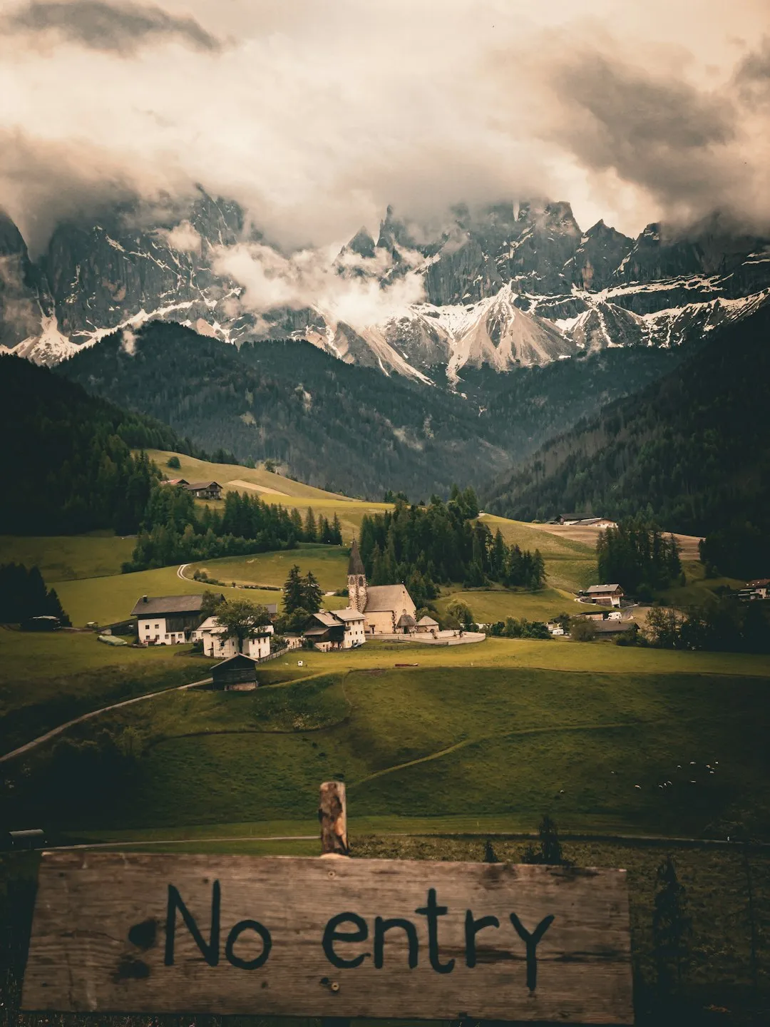
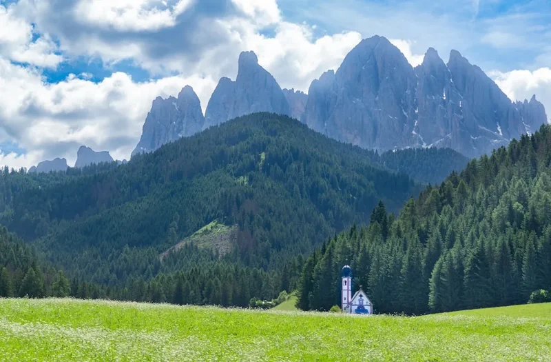
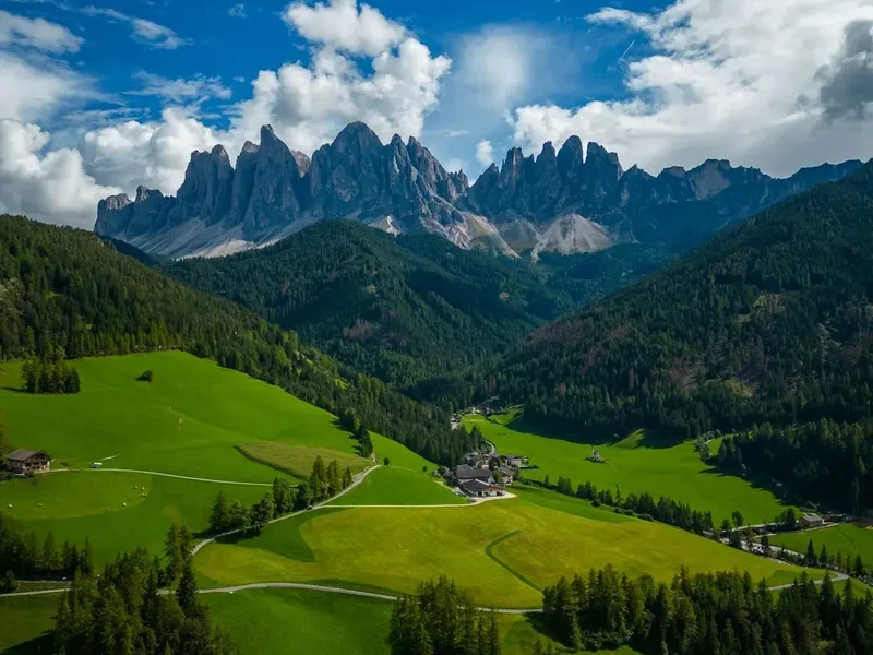
The Val di Funes Panorama Trail is a relatively short but intensely rewarding walk that encapsulates the quintessential beauty of the Dolomites. Its primary allure lies in the unobstructed, panoramic views of the Odle/Geisler peaks, which dominate the skyline with their sheer, pale grey rock faces and dramatic spires. The trail itself is well-maintained and generally wide, making for a comfortable walking experience. It begins in the vicinity of Santa Maddalena (St. Magdalena), a picturesque village renowned for its iconic church spire, which often features in photographs with the Odle peaks as a backdrop. From Santa Maddalena, the path ascends gradually, weaving through vibrant green alpine pastures dotted with traditional wooden farmhouses and grazing livestock. The elevation gain of 300 metres is spread out over the 5 kilometres, ensuring that the climb is never overly taxing, allowing walkers to focus on the ever-expanding vistas.
The trail’s name, "Panorama," is entirely fitting. As you gain altitude, the views open up dramatically. The Odle peaks, with their distinctive jagged silhouette, appear to rise directly from the valley floor, their imposing presence softened by the gentle slopes of the foreground meadows. The trail often follows the contours of the hillsides, offering changing perspectives of the mountain range and the surrounding valleys. In late spring and early summer, the meadows are carpeted with wildflowers, adding splashes of colour to the already stunning scenery. In autumn, the landscape transforms into a tapestry of golden hues, with the crisp mountain air making for invigorating walks. The trail is designed to be a sensory experience, engaging sight with its grand vistas, sound with the gentle tinkling of cowbells and the whisper of the wind, and smell with the fresh scent of pine and alpine flora.
This walk is particularly appealing because it offers such a high reward for a relatively low physical effort. It’s a perfect introduction to the Dolomites for those who may not be seasoned hikers, or for anyone seeking a day of spectacular natural beauty without the commitment of a multi-day trek. The accessibility from Bolzano and the availability of public transport make it a feasible day trip, allowing visitors to immerse themselves in the alpine environment and capture some of the most iconic imagery of the Italian Alps.
History and Cultural Context
The Val di Funes (Villnößtal in German) has a rich history deeply intertwined with the agricultural traditions of the South Tyrolean region. For centuries, the inhabitants of this valley have lived in close harmony with the dramatic mountain landscape, relying on farming and pastoralism for their livelihood. The distinctive farmhouses, often built with sturdy stone foundations and wooden upper levels, are a testament to this enduring connection to the land and the need to withstand the harsh alpine climate. The villages, such as Santa Maddalena, have retained their traditional charm, with their characteristic onion-domed churches and well-preserved architecture reflecting centuries of cultural influence, a blend of Italian and Austrian heritage.
The Odle/Geisler peaks themselves have long captured the imagination, not just of locals but also of artists, writers, and mountaineers. Their dramatic and almost otherworldly appearance has made them a subject of fascination and inspiration. In the late 19th and early 20th centuries, as mountaineering gained popularity, the Dolomites became a prime destination for exploration. While the Val di Funes Panorama Trail itself is a modern development designed for accessibility, the surrounding mountains have been a playground for climbers and hikers for generations. The area’s geological significance is also noteworthy; the Dolomites are composed of a unique type of limestone called dolomite, which gives the mountains their characteristic pale colour and dramatic shapes. This geological heritage is a key part of the region’s identity and its UNESCO World Heritage status.
The development of tourism in the Val di Funes, particularly the creation of well-marked trails like the Panorama Trail, has allowed a wider audience to appreciate the area's natural beauty. This has been balanced with efforts to preserve the traditional way of life and the pristine environment. The trail’s existence is a modern chapter in the valley’s long history, one that celebrates and shares its spectacular scenery while respecting its cultural roots and ecological integrity. The presence of traditional alpine huts (Malga/Almhütte) along or near the trail also speaks to the historical use of the high pastures for summer grazing, a practice that continues to shape the landscape and its cultural narrative.
Seasonal Highlights and Weather Reality
The Val di Funes Panorama Trail is best enjoyed during the warmer months, typically from May to October. Each season offers a distinct experience, with varying weather patterns and visual appeal.
Spring (May to June): This is a beautiful time to visit as the snow melts and the alpine meadows begin to bloom. Wildflowers emerge, painting the landscape with vibrant colours. The air is fresh, and the temperatures are generally mild, though higher elevations can still experience cool conditions. The crowds are usually smaller than in peak summer, offering a more tranquil experience. However, there's a higher chance of lingering snow patches on shaded sections of the trail, and occasional late spring snowfalls are possible.
Summer (July to August): This is the peak season for hiking in the Dolomites. The weather is typically warm and sunny, with long daylight hours perfect for exploring. The meadows are at their most lush, and the wildflowers are in full bloom. The trail is usually clear of snow, and all facilities, such as mountain huts (Malga/Almhütte), are open. However, summer can also bring afternoon thunderstorms, which are common in the mountains and can develop rapidly. It is essential to be prepared for sudden changes in weather, including rain and cooler temperatures at higher altitudes. Sandflies are not a significant issue in this region of Italy.
Autumn (September to October): Autumn offers a spectacular display of colours as the larch trees turn golden and the foliage changes. The air is crisp and clear, offering excellent visibility and often stable weather conditions. The crowds thin out considerably, providing a more peaceful hiking experience. Temperatures can become cooler, especially in the mornings and evenings, and by late October, there's a possibility of early snowfalls, particularly at higher elevations. The mountain huts may begin to close towards the end of October, so it's advisable to check their operating times.
Weather Reality: While the Val di Funes Panorama Trail is considered an easy walk, mountain weather is notoriously unpredictable. Even in summer, temperatures at higher points can drop significantly, and rain or fog can descend quickly, reducing visibility. It is crucial to check the weather forecast before setting out and to be prepared for all conditions with appropriate clothing and gear. The trail is generally well-marked, but in poor visibility, navigation can become more challenging.
Recommended Itinerary
Val di Funes Panorama Trail - Day Walk Itinerary
Early Morning: Arrival in Santa Maddalena
- Travel to Santa Maddalena (St. Magdalena) village in Val di Funes.
- Nearest airport: Bolzano (BZO).
- From Bolzano, take bus line 340 towards S. Maddalena/Santa Maddalena. The journey takes approximately 1 hour.
- Alternatively, drive from Bolzano; parking is available near the village church.
- Allow time to admire the iconic view of the church with the Odle/Geisler peaks behind it.
Morning: Trailhead and Ascent Start
- Begin the walk from the vicinity of the Santa Maddalena church.
- The trail is generally well-signposted, often marked with numbers or names indicating the panorama route.
- The initial section involves a gentle but steady ascent through meadows and past traditional farmsteads.
- Distance covered: Approximately 1.5 km.
- Elevation gain: Approximately 100-150 metres.
- Time taken: 45-60 minutes.
- Key waypoints: Santa Maddalena village, initial farmhouses, start of the meadow ascent.
Midday: Reaching Higher Pastures and Panoramic Views
- Continue ascending, with the Odle/Geisler peaks becoming increasingly prominent.
- The trail opens up into wider alpine pastures, offering expansive views.
- You may pass by or have the option to visit a Malga (alpine hut) for refreshments.
- Distance covered: Approximately 2.0 km.
- Elevation gain: Approximately 100-150 metres.
- Time taken: 60-75 minutes.
- Key waypoints: Malga Gampenalm (or similar, depending on exact route), viewpoints offering unobstructed Odle/Geisler vistas.
Afternoon: Summit Ridge and Descent
- Reach the highest point of the main panorama trail, offering the most commanding views.
- The trail may traverse a gentle ridge or a high meadow.
- Begin the descent, which often follows a slightly different but equally scenic path back towards Santa Maddalena or a nearby hamlet.
- Distance covered: Approximately 1.5 km.
- Elevation loss: Approximately 150-200 metres.
- Time taken: 45-60 minutes.
- Key waypoints: Highest viewpoint, descent path, return to Santa Maddalena village.
Late Afternoon: Return and Departure
- Arrive back in Santa Maddalena.
- Enjoy a final view of the iconic scenery.
- Option to visit a local café or restaurant for a well-deserved treat.
- Depart from Santa Maddalena via bus or private transport.
Important Notes:
- This is a day hike; no overnight accommodation is required on the trail itself.
- The trail is well-marked, but carrying a map or using a GPS device is always recommended.
- Wear sturdy walking shoes or hiking boots.
- Carry water and snacks, although refreshments are often available at Malga/Almhütten along the route.
- Be prepared for changing mountain weather.
Planning and Bookings
Book Your Trip
Everything you need to plan your journey
Accommodation
Find places to stay near Bolzano
Flights
Search flights to Bolzano
Essential Preparation
The Val di Funes Panorama Trail is a day walk, meaning no advance bookings for accommodation are necessary. However, essential preparation focuses on logistics, transport, and understanding the local environment. The closest major city and transport hub is Bolzano (Bozen). From Bolzano, public transport is the most convenient way to reach Santa Maddalena (St. Magdalena), the primary starting point for the trail. Bus line 340 operates regularly, connecting Bolzano with Val di Funes. It is advisable to check the current bus schedules in advance, especially if travelling outside of peak season, as services may be less frequent. If driving, there is parking available in Santa Maddalena, though it can become busy during peak times. Familiarise yourself with the trail route using maps or a reliable hiking app. While the trail is generally easy to follow, understanding the terrain and potential variations is beneficial. The best time to visit is from May to October, with July and August being the busiest months. Consider visiting during the shoulder seasons (May-June or September-October) for fewer crowds and potentially more stable weather.
Trail Accommodation
This is a day hike requiring no overnight accommodation.
Required Gear
- Footwear: Sturdy walking shoes or hiking boots with good grip are essential. Trainers may suffice for very dry conditions, but boots offer better ankle support and protection.
- Clothing: Layers are key. A moisture-wicking base layer, an insulating mid-layer (fleece or lightweight down jacket), and a waterproof and windproof outer shell are recommended. Even in summer, mountain weather can change rapidly, and temperatures can drop significantly at higher elevations.
- Headwear: A sun hat or cap for protection from the sun, and a warm beanie for cooler conditions.
- Eyewear: Sunglasses are important to protect your eyes from the strong alpine sun, even on cloudy days.
- Navigation: A map of the area and a compass, or a reliable GPS device/smartphone with offline maps downloaded. While the trail is well-marked, it's always wise to have backup navigation tools.
- Safety: A basic first-aid kit including plasters, antiseptic wipes, pain relievers, and any personal medications. A whistle can be useful in emergencies.
What to Bring
- Water: Carry at least 1-1.5 litres of water per person. Refill opportunities may exist at Malga/Almhütten, but it's best to start with sufficient supply.
- Food: Pack snacks such as energy bars, fruit, nuts, or sandwiches. While there are huts along the route that serve food and drinks, having your own provisions ensures you are prepared.
- Sun Protection: High SPF sunscreen is crucial, as the sun's rays are intense at altitude.
- Backpack: A comfortable daypack (20-30 litres) to carry your essentials.
- Camera: Essential for capturing the stunning scenery!
- Cash: Some Malga/Almhütten may prefer cash payments, especially for smaller purchases.
- Insect Repellent: Generally not a major issue in this region, but a small amount can be useful if you are particularly sensitive.
- Trekking Poles (Optional): Can be helpful for stability, especially on descents, and can reduce strain on the knees.
Permits
No specific permits are required to walk the Val di Funes Panorama Trail. As a public hiking route within the Dolomites, access is generally free and open to all. The trail is part of the extensive network of paths managed by local authorities and hiking associations in South Tyrol. While no permits are needed, it is important to respect the natural environment and any local regulations that may be in place to preserve the landscape and its cultural heritage. This includes staying on marked paths, not disturbing wildlife, and taking all litter with you. The area is part of a UNESCO World Heritage site, and adherence to responsible tourism practices is encouraged to help maintain its pristine condition.
Other Activities in the Area
Beyond the Panorama Trail, Val di Funes and its surroundings offer a wealth of activities for visitors:
- Exploring Santa Maddalena Village: Spend time wandering through the charming village of Santa Maddalena, admiring its iconic church and traditional architecture. The views from the village itself are spectacular.
- Visiting other Malga/Almhütten: The region is dotted with numerous alpine huts that serve delicious local cuisine, including hearty South Tyrolean dishes and refreshing beverages. Many offer stunning views and are perfect stops for lunch or a break.
- Hiking in the Puez-Odle Nature Park: The Val di Funes is part of the larger Puez-Odle Nature Park, offering a vast network of trails for all levels of hikers. Longer and more challenging routes can be explored, leading deeper into the heart of the Dolomites.
- Photography: The Val di Funes is a photographer's paradise. The Odle/Geisler peaks provide a dramatic and ever-changing subject, especially during sunrise and sunset.
- Cycling: Mountain biking routes are available in the wider region, offering a different perspective on the alpine landscape.
- Via Ferrata: For experienced climbers, the Dolomites offer numerous "Via Ferrata" routes – protected climbing paths equipped with steel cables, rungs, and ladders, allowing access to otherwise inaccessible peaks.
- Visiting nearby towns: Explore other charming towns in the region, such as Brixen (Bressanone) or Ortisei, each with its own unique character and attractions.
- Skiing (Winter): In winter, the region transforms into a popular ski destination, with several resorts offering excellent slopes and winter sports opportunities.
Safety and Conditions
Weather: Mountain weather can change very rapidly. Always check the local forecast before you set out and be prepared for sudden shifts in temperature, wind, and precipitation. Afternoon thunderstorms are common in summer and can be dangerous. If you see dark clouds gathering, seek lower ground or shelter.
Trail Conditions: The Val di Funes Panorama Trail is generally well-maintained and clearly marked. However, sections can be uneven, rocky, or muddy, especially after rain. Wear appropriate footwear with good grip.
Navigation: While the trail is popular and well-signposted, it is advisable to carry a map and compass or use a GPS device with offline maps. Familiarise yourself with the route before you start.
Altitude: The trail reaches moderate altitudes. While not extremely high, be aware of the effects of altitude, especially if you are not accustomed to it. Stay hydrated and take breaks as needed.
Hydration and Nutrition: Carry sufficient water and snacks. While there are huts (Malga/Almhütten) along the route, they may not always be open, or you might need sustenance between stops. Ensure you have enough to last the entire walk.
Emergency Contacts: In case of an emergency, know the local emergency numbers. In Italy, the general emergency number is 112. It is also advisable to inform someone of your hiking plans, including your intended route and expected return time.
Sun Protection: The sun's rays are stronger at higher altitudes. Use sunscreen, wear a hat, and sunglasses to protect yourself from sunburn and UV damage.
Respect the Environment: Stay on marked trails to avoid damaging fragile vegetation and to prevent erosion. Take all litter with you. Do not disturb wildlife.
Side Trips and Points of Interest
Santa Maddalena Church: The iconic church of Santa Maddalena is a must-see. Its picturesque setting with the Odle/Geisler peaks as a backdrop is one of the most photographed scenes in the Dolomites. Take time to appreciate its architecture and the serene atmosphere.
Malga Gampenalm (and other huts): Along the Panorama Trail, you will likely pass several traditional alpine huts (Malga/Almhütten). These offer opportunities to rest, enjoy local refreshments and food, and soak in the atmosphere of the high pastures. Gampenalm is a popular stop, known for its views and traditional fare.
Viewpoints of the Odle/Geisler Peaks: The entire trail is essentially a series of viewpoints. However, specific points along the higher sections offer particularly dramatic and unobstructed panoramas of the jagged Odle/Geisler massif. Keep an eye out for designated viewing spots or simply pause where the landscape opens up.
Alpine Meadows and Flora: Depending on the season, the meadows along the trail are a delight. In spring and early summer, they are carpeted with a variety of wildflowers. Even in late summer and autumn, the colours of the grasses and the hardy alpine plants are beautiful.
Traditional Farmhouses: Scattered throughout the lower slopes are traditional Tyrolean farmhouses, often with colourful flower boxes and characteristic wooden architecture. These offer a glimpse into the rural life of the region.
Leave No Trace
The Val di Funes and the surrounding Puez-Odle Nature Park are part of a UNESCO World Heritage site, recognised for their outstanding natural beauty and geological significance. Preserving this environment for future generations is paramount. As a visitor, you play a crucial role in ensuring that your impact is minimal.
Plan Ahead and Prepare: Understand the trail conditions, weather, and any local regulations before you go. Pack appropriately to avoid needing to improvise or leave items behind.
Travel and Camp on Durable Surfaces: Stick to marked trails. Avoid walking on fragile vegetation, especially alpine meadows, which can take years to recover from damage. The Panorama Trail is well-defined, so follow its path.
Dispose of Waste Properly: Pack out everything you pack in. This includes all food scraps, wrappers, and any other litter. Use the bins provided in villages or carry your waste until you can dispose of it responsibly. Do not leave anything behind, even organic materials like apple cores, as they can disrupt the local ecosystem.
Leave What You Find: Do not pick wildflowers or remove rocks or other natural objects. These are part of the natural heritage of the area.
Minimise Campfire Impacts: Not applicable for this day hike, as camping is not permitted on the trail.
Respect Wildlife: Observe wildlife from a distance and never feed animals. Feeding them can alter their natural behaviour and diet, and can be harmful to their health.
Be Considerate of Other Visitors: Keep noise levels down, especially in natural settings. Yield to other hikers when necessary. The Val di Funes is a place of peace and natural beauty; help maintain this atmosphere.