Ushuaia to Cabo San Pablo Trek - Journey to the Edge of the Atlantic
The Ushuaia to Cabo San Pablo Trek is one of the most remote and evocative wilderness experiences in South America. Spanning approximately 130 kilometres along the rugged, wind-swept coastline of Tierra del Fuego, this journey takes intrepid walkers from the southernmost city in the world, Ushuaia, toward the hauntingly beautiful remains of the Desdemona shipwreck at Cabo San Pablo. This is not a manicured trail; it is a raw expedition through a landscape defined by the convergence of the Andes and the Atlantic Ocean. Walkers must navigate vast peat bogs (known locally as turbales), ancient subantarctic forests of lenga and ñire trees, and desolate beaches where the only company is the occasional guanaco or soaring Andean condor. It is a trek that demands self-sufficiency, resilience against the relentless Patagonian winds, and a deep respect for the "Fin del Mundo" (End of the World).
- Distance: 130.0 km one-way
- Duration: 5–7 days
- Season: October–April (shoulder seasons of October/November and March/April offer the best balance of light and manageable winds)
- Accommodation: Wild camping (no formal huts or campsites; self-sufficiency is mandatory)
- Highest point: Approximately 500 m (coastal cliffs and inland passes)
- Difficulty: Moderate to Challenging (due to navigation, peat bogs, and extreme weather)
- Direction: Generally walked South to North (Ushuaia/Estancia Moat to Cabo San Pablo)
Overview
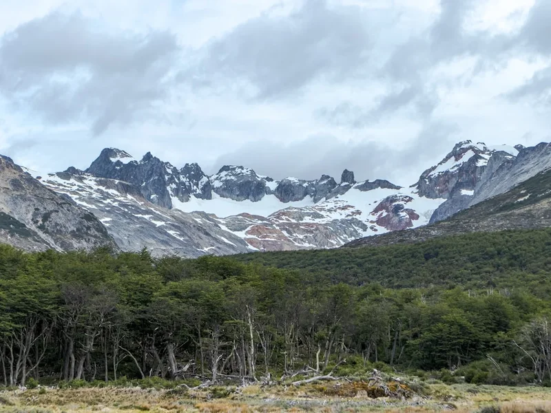
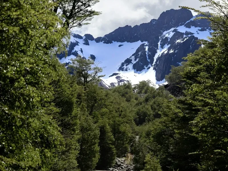
The Ushuaia to Cabo San Pablo Trek is a masterclass in isolation. While many visitors to Tierra del Fuego stick to the well-trodden paths of Tierra del Fuego National Park, this coastal traverse offers a glimpse into the true wilderness of the Isla Grande. The route begins near the end of the southernmost road in the world and strikes out into the Mitre Peninsula's fringes, following a coastline that has claimed countless ships over the centuries. The landscape is a dramatic tapestry of dark, churning seas, grey pebble beaches, and the emerald-green hues of the Fuegian forests. The terrain is notoriously difficult; the "turbales" (peat bogs) can be waist-deep in places, requiring careful route-finding and a willingness to get wet and muddy.
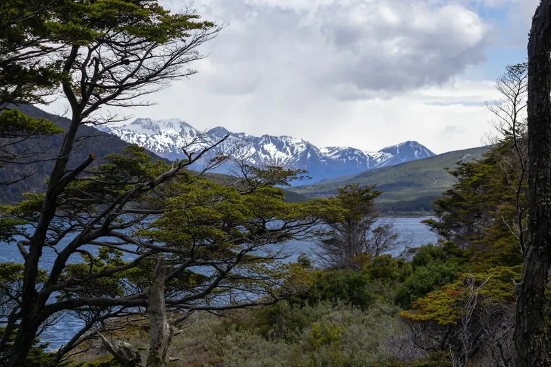
The weather is the primary protagonist of this trek. Tierra del Fuego is famous for experiencing "four seasons in one day." Walkers can expect horizontal rain, sudden snow squalls even in mid-summer, and the legendary Patagonian winds that can reach speeds of over 100 kilometres per hour. However, when the clouds part, the light is unlike anywhere else on Earth—a sharp, crystalline clarity that illuminates the snow-capped peaks of the Darwin Range to the west and the endless horizon of the Atlantic to the east. The trek concludes at Cabo San Pablo, a dramatic headland featuring a lonely lighthouse and the rusted, iconic hull of the Desdemona, a merchant ship run aground in 1985, serving as a silent monument to the power of these waters.
This is a journey for those who seek silence and the profound psychological shift that comes from walking for days without seeing another human soul. There are no waymarkers, no bridges over the glacial rivers, and no emergency shelters. Success on this route depends on meticulous planning, high-quality gear, and an adventurous spirit. It is a trek that strips away the modern world, leaving only the rhythm of the tides and the sound of the wind in the southern beech trees.
History and Cultural Context
The history of the land between Ushuaia and Cabo San Pablo is a poignant blend of indigenous heritage, maritime tragedy, and the rugged era of the estancias (ranches). For thousands of years, this region was the ancestral home of the Selk'nam (Ona) and Haush people. Unlike the Yaghan who navigated the Beagle Channel in canoes, the Selk'nam were terrestrial hunters who roamed the interior and the Atlantic coast, hunting guanaco and gathering shellfish. Their culture was deeply tied to the spiritual significance of the mountains and the harsh coastal environment. Tragically, the arrival of European sheep farmers and gold prospectors in the late 19th century led to the rapid and violent displacement of these indigenous groups, a dark chapter in Argentine history that still resonates today.
As the indigenous populations declined, the land was divided into massive estancias. Pioneers like the Bridges family established outposts in these remote corners, attempting to raise sheep in one of the most inhospitable climates on the planet. Many of the "trails" used today are actually old cattle paths or "sendas" established by the gauchos who moved livestock between coastal pastures. Walking this route, you will occasionally stumble upon the ruins of old puestos (outposts)—small wooden shacks that once provided shelter to lonely shepherds. These structures, slowly being reclaimed by the forest and the wind, are a testament to the grit of the early settlers.
The maritime history is equally compelling. The coast of Tierra del Fuego is a graveyard of ships. The most famous landmark on this trek, the Desdemona, was an Argentine cargo ship that ran aground at Cabo San Pablo in June 1985 to avoid sinking after hitting a reef. The sight of the massive, rusted vessel sitting high on the sand at low tide is a powerful reminder of the treacherous nature of the South Atlantic. The trek is not just a physical challenge; it is a walk through a landscape of ghosts, where the stories of the Selk'nam, the gauchos, and the shipwrecked sailors are etched into every cliff and cove.
Want more background? Read extended notes on history and cultural context → Learn more
Seasonal Highlights and Weather Reality
Tierra del Fuego does not adhere to standard seasonal expectations. The weather is governed by the Southern Ocean and the Antarctic winds, meaning conditions can change with startling rapidity. The trekking season is strictly limited to the southern hemisphere's late spring, summer, and early autumn.
Summer (December to February): This is the most popular time to attempt the trek. The days are incredibly long, with up to 18 hours of daylight, providing ample time for navigation and bog-crossing. Temperatures typically range from 5°C to 15°C, though the wind chill can make it feel much colder. This is also the windiest season; the "Roaring Forties" and "Furious Fifties" winds are at their peak, which can make walking along exposed coastal cliffs exhausting and potentially dangerous.
Shoulder Seasons (October–November and March–April): These months are often preferred by experienced trekkers. The winds are generally less ferocious than in mid-summer, and the landscape undergoes dramatic transformations. In October and November, the spring wildflowers begin to bloom, and the mountains are still heavily capped with winter snow. In March and April, the lenga forests turn a brilliant, fiery red and orange—a spectacle known as the "Fuegian Autumn" that is arguably the most beautiful time to be in the region. However, nights are significantly colder, often dropping below freezing, and the window of daylight is shorter.
Winter (May to September): The trek is virtually impassable during winter for anyone other than expert winter expeditionists. The peat bogs freeze (which can actually make walking easier), but the deep snow, short days (only 6-7 hours of light), and extreme sub-zero temperatures make it a survival exercise rather than a trek. Most access roads to the trailheads are closed or blocked by snow during this time.
Recommended Itinerary
7-Day Ushuaia to Cabo San Pablo Expedition
Day 1: Ushuaia to Estancia Moat and Rio Chico
- Distance: 12 km (trekking) + 100 km (transport from Ushuaia)
- Elevation gain: 150 m
- Time: 4–5 hours trekking
- Morning private transfer from Ushuaia to the end of Provincial Route J at Estancia Moat
- Begin the trek heading northeast along the Beagle Channel's eastern mouth
- Navigate the first sections of subantarctic forest and coastal meadows
- Cross the Rio Moat (check tide levels for easier crossing)
- Camp near the mouth of Rio Chico, overlooking the turbulent waters where the channel meets the Atlantic
- First night of wild camping; ensure the tent is well-anchored against coastal gusts
Day 2: Rio Chico to Bahía Sloggett
- Distance: 18 km
- Elevation gain: 200 m
- Time: 7–8 hours
- A challenging day involving the first major encounters with "turbales" (peat bogs)
- Follow the coastline, occasionally climbing onto cliffs to bypass impassable rocky sections
- Pass the remains of old gold mining equipment from the late 19th-century "gold rush"
- Arrive at the wide, sweeping Bahía Sloggett
- The bay is famous for its "black sands" and the rusted remains of a steam shovel used by miners
- Camp in the shelter of the trees at the edge of the bay to escape the wind
Day 3: Bahía Sloggett to Bahía Aguirre
- Distance: 22 km
- Elevation gain: 300 m
- Time: 8–10 hours
- One of the longest and most strenuous days of the trek
- The route moves inland slightly to cross a series of forested ridges
- Navigation becomes critical here as cattle paths can be misleading
- Descend into Bahía Aguirre, a site of significant historical tragedy (where missionary Allen Gardiner perished)
- The bay offers spectacular views of the rugged Mitre Peninsula to the east
- Camp near the freshwater streams at the western end of the bay
Day 4: Bahía Aguirre to Puerto Español
- Distance: 15 km
- Elevation gain: 100 m
- Time: 5–6 hours
- A shorter day to allow for recovery and to manage the difficult river crossings
- Walk along the shoreline of Bahía Aguirre, watching for dolphins and seals in the bay
- The terrain is a mix of pebble beaches and dense forest fringes
- Arrive at Puerto Español, a relatively sheltered cove
- Explore the ruins of old pioneer settlements in the area
- Excellent camping spots are available in the grassy clearings behind the beach
Day 5: Puerto Español to Rio Irigoyen
- Distance: 25 km
- Elevation gain: 150 m
- Time: 9–11 hours
- A massive day heading north toward the Atlantic coast proper
- The landscape opens up into vast, windswept plains and massive peat bogs
- The Rio Irigoyen is a major river; crossing must be timed with low tide or found at a shallow braided section inland
- This area is world-renowned for sea-run brown trout, though you are unlikely to see any anglers in this remote section
- Camp on the northern bank of the Irigoyen, using the driftwood for windbreaks
Day 6: Rio Irigoyen to Estancia Maria Luisa
- Distance: 20 km
- Elevation gain: 100 m
- Time: 7–8 hours
- The trek begins to approach the fringes of "civilisation" (remote estancias)
- The coastline becomes more accessible, with long stretches of sandy and pebble beaches
- Pass through areas of "dead forest" where trees have been bleached white by the salt and wind
- Approach Estancia Maria Luisa, one of the most remote working ranches in the region
- Camp near the estancia (with permission) or in the nearby dunes
Day 7: Estancia Maria Luisa to Cabo San Pablo
- Distance: 18 km
- Elevation gain: 100 m
- Time: 6–7 hours
- The final push toward the iconic landmark of the trek
- The Desdemona shipwreck becomes visible on the horizon as you round the final headlands
- Walk the long, flat beaches toward the cape
- Climb the hill to the San Pablo lighthouse for a panoramic view of the Atlantic
- Explore the Desdemona at low tide (be extremely careful of the rising tide)
- Finish at the end of the gravel road where your pre-arranged transport will meet you for the drive back to Ushuaia or Rio Grande
Important Notes:
- This itinerary is highly dependent on river levels and tide times; flexibility is essential
- There are no marked trails; GPS and topographical maps are mandatory
- Water is plentiful but must be treated due to the presence of livestock and beavers
- Beavers are an invasive species here; their dams often flood the "sendas" (paths), forcing detours
- Always inform the Gendarmería (Border Guard) in Ushuaia of your plans before departing
Planning and Bookings
Book Your Trip
Everything you need to plan your journey
Accommodation
Find places to stay near Ushuaia
Flights
Search flights to Ushuaia
Essential Preparation
The Ushuaia to Cabo San Pablo Trek is a serious undertaking that requires significant logistical coordination. Unlike the Great Walks of New Zealand or the popular routes in Torres del Paine, there is no central booking system or "trail pass." Preparation begins with physical conditioning; you must be comfortable carrying a 20–25 kg pack over uneven, boggy terrain for 8–10 hours a day. Your "base town" will be Ushuaia, which has all the necessary amenities, including outdoor gear shops (though prices are high due to import taxes), supermarkets, and transport hubs.
Logistics are the most challenging part. This is a one-way trek. You will need to arrange a private transfer to Estancia Moat (about 100 km from Ushuaia) and a pre-arranged pickup at Cabo San Pablo. There is no public transport to either end. Communication is vital; since there is no mobile signal for 95% of the trek, carrying a satellite communication device (like a Garmin inReach) is non-negotiable for safety and for coordinating your final pickup.
Trail Accommodation
There is no formal accommodation on the Ushuaia to Cabo San Pablo Trek. This is a pure wild camping experience.
Camping Realities:
- You must bring a high-quality, four-season tent capable of withstanding 100 km/h winds.
- Campsites are self-selected. Look for "puestos" (old shepherd huts) which sometimes offer a flat, slightly sheltered spot nearby, but never rely on the huts themselves as they are often derelict or vermin-infested.
- Shelter is your priority. The best spots are usually just inside the tree line of the lenga forests, which provide a natural windbreak.
- Avoid camping in low-lying areas of the "turbales" as they can become saturated quickly during rain.
- There are no fees for camping, but if you are near a working estancia (like Maria Luisa), it is common courtesy to ask for permission if you encounter any staff.
Required Gear
- Four-season tent: Must have a low profile and strong pole structure for Patagonian winds.
- Gaiters: Essential. You will be walking through deep mud and peat bogs daily; gaiters are the only thing keeping debris out of your boots.
- Waterproof boots: High-quality leather or Gore-Tex boots with stiff soles. Ensure they are thoroughly broken in.
- GPS and Paper Maps: A dedicated GPS unit with extra batteries is mandatory. The "trail" is often just a series of disconnected cattle paths.
- Satellite Messenger: (e.g., Garmin inReach or Zoleo) for emergencies and logistics.
- Stove and Fuel: Multi-fuel or canister stoves. Note: Gas canisters (isobutane) are available in Ushuaia but cannot be taken on planes.
- Sleeping Bag: Rated to at least -5°C comfort. Even in summer, frost is common.
- Backpack: 65–75L with a very high-quality harness system to manage the weight of 7 days of food.
What to Bring
- Food for 8 days: Always bring one extra day of rations in case of river flooding or weather delays. Focus on high-calorie, lightweight dehydrated meals.
- Water Treatment: A filter or chlorine dioxide drops. While the water looks clear, beavers have introduced Giardia to many Fuegian watersheds.
- Dry Bags: Everything inside your pack must be in dry bags. The rain in Tierra del Fuego is persistent and pervasive.
- Trekking Poles: Essential for stability in the bogs and for probing the depth of mud before stepping.
- Repair Kit: Include gear for tent pole repair, sleeping pad patches, and plenty of duct tape.
- Personal First Aid: Focus on blister care (moleskin/Leukotape) and anti-inflammatories.
- Clothing: The layering system is key. Merino wool base layers, a heavy fleece or "puffy" jacket, and a professional-grade hardshell jacket (Gore-Tex Pro or similar).
Permits
Currently, there is no official permit required by the Argentine National Parks or provincial authorities to walk the coast toward Cabo San Pablo. However, this does not mean there are no "permissions" involved. Much of the land you will traverse is technically private property belonging to various large estancias, or it is "Tierras Fiscales" (government land) with restricted access.
Mandatory Notifications:
- Gendarmería Nacional: Before leaving Ushuaia, you should visit the Gendarmería office. Provide them with your intended route, your expected return/pickup date, and the details of your emergency contact and satellite device. This is for your own safety; if you do not check in by your deadline, they are the ones who will coordinate a search.
- Estancia Permissions: While you won't find a ticket booth, if you encounter gauchos or estancia managers, be polite and explain your journey. Most are welcoming to respectful trekkers, but they appreciate being informed of people moving across their land, especially regarding the risk of fire.
Logistical Costs:
- While the "trail" is free, the logistics are not. A private 4x4 transfer from Ushuaia to Estancia Moat can cost between US$150 and US$250 depending on the provider.
- A pickup from Cabo San Pablo back to Ushuaia is similarly priced. It is often more cost-effective to arrange this with a local tour operator or a specialized mountain taxi service in Ushuaia.
- Ensure you have your logistics confirmed at least a week in advance, as vehicles are limited.
Other Activities in the Area
Ushuaia is the adventure capital of the south, and there are numerous ways to complement your trek:
- Beagle Channel Navigation: Take a catamaran or sailboat tour to see the Les Eclaireurs Lighthouse, sea lion colonies, and Magellanic penguins on Isla Martillo.
- Tierra del Fuego National Park: Explore the more accessible (but still beautiful) trails like the Coastal Path or the climb to Pampa Alta.
- Martial Glacier: A short but steep hike from the city centre offering bird's-eye views of the Beagle Channel and the city.
- Laguna Esmeralda: A popular day hike to a stunning glacial lake, perfect for a "warm-up" before your main expedition.
- End of the World Train: A historical steam train that follows the route once used by prisoners to collect wood for the Ushuaia penal colony.
- Museum of the End of the World: Essential for understanding the indigenous history and maritime heritage of the region you just walked.
Safety and Conditions
The "Turbales" (Peat Bogs): The single greatest physical hazard on this trek is the peat bog. These are deep, water-saturated accumulations of organic matter. In some places, they are firm; in others, they are "floating" and can swallow a leg (or more) instantly. Always use trekking poles to test the ground. If the ground feels bouncy or "spongy," look for a route around the edge or stick to the higher ground where the bushes grow.
Hypothermia: This is a constant threat. The combination of wet clothing, high winds, and temperatures near freezing is the perfect recipe for hypothermia. You must have a "dry set" of clothes kept in a waterproof bag that is only worn inside the tent. Never continue walking if you are shivering uncontrollably; stop, find shelter, and get into your sleeping bag.
River Crossings: The rivers in Tierra del Fuego are glacial and can rise rapidly after rain or snowmelt. The Rio Moat, Rio Chico, and Rio Irigoyen are the most significant. Always attempt crossings at low tide if near the coast, or look for wide, braided sections. Never cross a river that is above mid-thigh height; the current is deceptively strong.
Wildlife: While there are no large predators (the Fuegian fox is the largest native carnivore), the feral cattle can be aggressive. If you encounter a bull, give it a very wide berth. Do not attempt to approach or "shoo" them away. Additionally, be aware of the "Beaver Dams"—these can make river crossings much more complex and can flood large areas of the forest.
Emergency Communication: There is no cell service. A satellite messenger is your only link to the outside world. Ensure you know how to use the SOS function and that your emergency contacts know your itinerary.
Side Trips and Points of Interest
The Desdemona Shipwreck: The ultimate goal of the trek. Located at Cabo San Pablo, this 75-metre cargo ship is one of the most photographed wrecks in the world. At low tide, you can walk right up to the hull. The interior is a labyrinth of rusted iron and sea-salt, but entering the wreck is dangerous due to sharp metal and unstable structures. It is best enjoyed from the outside as the tide comes in, surrounding the ship with the Atlantic's grey waters.
Bahía Sloggett Steam Shovel: A bizarre sight in the middle of the wilderness. This massive, rusted piece of Victorian-era engineering was brought here during the gold rush. It stands as a monument to human ambition and the failure to conquer this landscape. It is a fantastic spot for photography and a reminder of the area's industrial history.
Cabo San Pablo Lighthouse: A small, modern lighthouse sits atop the cliff overlooking the Desdemona. The climb to the top of the hill provides the best vantage point for the entire coastline you have just traversed. On a clear day, you can see for dozens of kilometres in every direction.
The "Flag Trees": Throughout the trek, you will see lenga trees that have grown at a permanent 45-degree angle due to the constant wind. These "Arboles Bandera" (Flag Trees) are iconic symbols of Tierra del Fuego and provide a stark visual representation of the environmental forces at play.
Leave No Trace

The ecosystem of Tierra del Fuego is incredibly fragile. The subantarctic forests and peat bogs take centuries to recover from damage. Because this trek is so remote, there is no one to clean up after you. You must be a steward of this wilderness.
Leave No Trace Principles for Tierra del Fuego:
- Fire is the greatest danger: Wildfires in this region are catastrophic because the peat soil can burn underground for months. Never make an open campfire. Use a camping stove for all cooking.
- Pack it in, pack it out: This includes all food scraps, tea bags, and especially toilet paper. Use a "poop tube" or carry out all used paper in sealed bags.
- Respect the Turbales: Try to walk on established cattle paths or rocky ground to avoid further eroding the peat bogs.
- Wildlife: Do not feed the foxes or birds. Keep a respectful distance from guanacos and sea lions.
- Archaeological Sites: If you find Selk'nam arrowheads or old pioneer tools, leave them exactly where they are. They are part of the historical record of the land.