
Tucanare to Choro Trek
The Tucanare to Choro Trek is a challenging multi-day expedition through the rugged Cordillera Real mountain range in Bolivia, offering a profound immersion into high-altitude Andean landscapes. This trek is not for the faint-hearted, demanding significant physical fitness, acclimatisation to extreme altitudes, and a robust spirit of adventure. Traversing remote valleys, crossing high mountain passes, and navigating varied terrain, the Tucanare to Choro Trek provides an authentic experience of the Bolivian Andes, far from the usual tourist trails.
- Distance: 65.0 km
- Duration: 3-4 days
- Season: May to September (dry season)
- Elevation Gain: 3,000 m
- Difficulty: Challenging
- Closest City: La Paz
- Trailhead Access: From La Paz, take a bus to La Cumbre (approx. 1 hour). From La Cumbre, hire a taxi or shared transport to Tucanare (trailhead). Road is unpaved and can be rough. No permits required at trailhead.
- Coordinates: -16.2888, -67.8703
Overview
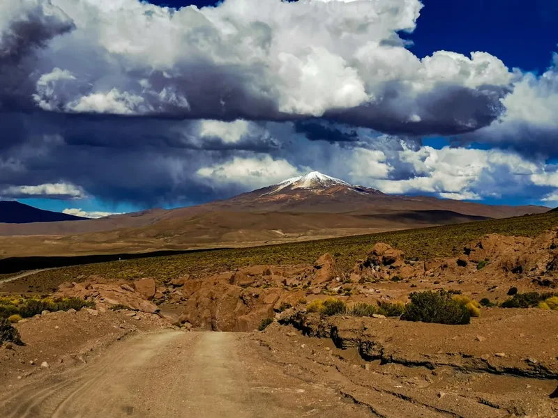
The Tucanare to Choro Trek is a journey that encapsulates the raw beauty and formidable challenges of the Bolivian Andes. Beginning in the vicinity of Tucanare, a remote starting point accessible from the high-altitude pass of La Cumbre, the trek quickly plunges into dramatic glacial valleys. The initial stages are characterised by steep descents and ascents, often on narrow, rocky paths that demand careful footing. As the trek progresses, walkers will encounter a diverse range of ecosystems, from the sparse, high-altitude puna grasslands dotted with ichu grass and hardy shrubs, to more sheltered valleys where small agricultural communities may be found.
The trek's defining feature is its extreme elevation. The route frequently crosses passes well above 4,000 metres, with the highest points potentially reaching over 4,500 metres. These altitudes necessitate careful acclimatisation to avoid altitude sickness. The air is thin, the sun intense, and the temperatures can fluctuate dramatically between day and night, often dropping below freezing after sunset. The landscape is sculpted by ancient glaciers, with U-shaped valleys, moraines, and occasional glacial lakes providing stark and beautiful scenery.
While the Tucanare to Choro Trek is primarily a wilderness experience, there are opportunities to interact with local Aymara communities. These encounters offer a glimpse into traditional Andean life, where subsistence farming and herding are still prevalent. The trek culminates near Choro, from where onward travel can be arranged back to La Paz. This trek is an excellent choice for experienced trekkers seeking a genuine high-altitude adventure in a less-travelled region of the Andes.
History and Cultural Context
The Cordillera Real, where the Tucanare to Choro Trek is situated, has been a significant region for human activity for millennia. Ancient Andean civilisations, including the Tiwanaku culture and later the Inca Empire, utilised these high-altitude routes for trade, communication, and religious purposes. The Inca, in particular, established extensive road networks (Qhapaq Ñan) that traversed these formidable mountains, connecting their vast empire. While the specific Tucanare to Choro route may not be a major historical Inca highway, it follows ancient pathways that have been used by indigenous peoples for centuries.
The Aymara people, who have inhabited this region for generations, have a deep and enduring connection to the land. Their traditional way of life is intrinsically linked to the cycles of nature, the seasons, and the spirits of the mountains (Apus). Farming at these altitudes is challenging, with crops like potatoes and quinoa being staples, alongside herding of llamas and alpacas. The communities encountered along the trek often maintain these traditional practices, offering a window into a resilient culture that has adapted to one of the world's harshest environments.
In more recent history, the Cordillera Real has become a destination for mountaineers and trekkers drawn by its dramatic peaks and challenging terrain. However, the Tucanare to Choro Trek remains relatively undeveloped, preserving a sense of wildness and authenticity. The lack of extensive infrastructure means that trekkers are largely self-sufficient, relying on their own gear and provisions, which adds to the sense of adventure and discovery.
Seasonal Highlights and Weather Reality
The best time to undertake the Tucanare to Choro Trek is during the dry season, which typically runs from May to September. This period offers the most stable weather conditions, with clear skies and significantly less rainfall compared to the wet season.
Dry Season (May to September):
- May-June: The start of the dry season often brings crisp, clear days and cold nights. The landscape can be dusted with early snow at higher elevations, creating stunning visual contrasts. Temperatures can drop well below freezing, especially at night.
- July-August: These are generally considered the prime months for trekking. Days are typically sunny and bright, though still cool. Nights are very cold, often reaching -10°C or lower at higher camps. This is the peak season for visibility and the most reliable weather.
- September: The end of the dry season can still offer good trekking conditions, but there's a slightly increased chance of early rains or snow showers as the transition to the wet season begins. The landscape may appear drier.
Wet Season (October to April):
The wet season is generally not recommended for this trek due to several significant hazards:
- Heavy Rainfall: Frequent and intense rain can lead to flash floods in valleys, making river crossings dangerous or impossible.
- Mudslides and Landslides: Steep slopes become unstable, increasing the risk of rockfalls and mudslides, which can block trails or pose a direct threat.
- Poor Visibility: Persistent cloud cover and fog significantly reduce visibility, making navigation difficult and obscuring the stunning mountain scenery.
- Snow and Ice: Higher passes can receive significant snowfall, making them impassable without specialised winter mountaineering equipment and skills.
- Cold and Damp Conditions: The combination of rain and cold temperatures increases the risk of hypothermia.
Weather Considerations: Even during the dry season, weather in the Andes can change rapidly. Be prepared for strong winds, sudden temperature drops, and occasional rain or snow showers, especially at higher altitudes and on exposed passes. Always check the latest weather forecasts before and during your trek.
Recommended Itinerary
3-Day Tucanare to Choro Trek Itinerary
Day 1: Tucanare (approx. 3,800 m) to High Camp (approx. 4,400 m)
- Distance: 15 km
- Elevation gain: 600 m
- Time: 6–8 hours
- Start from Tucanare, a remote starting point accessible via La Cumbre pass.
- The initial part of the trek involves a steep ascent through high-altitude puna grasslands.
- Navigate rocky terrain and potentially cross small streams.
- The landscape is stark and beautiful, with expansive views of the surrounding peaks.
- Establish camp at a designated high camp location, chosen for shelter and proximity to the pass.
- Nights at this altitude are very cold, often dropping below freezing.
Day 2: High Camp to Choro Valley Camp (approx. 3,600 m) via Choro Pass (approx. 4,700 m)
- Distance: 20 km
- Elevation gain: 300 m to pass, 1,100 m descent
- Time: 7–9 hours
- Early morning start to tackle the highest point of the trek, Choro Pass.
- The ascent to the pass is challenging due to altitude and steepness.
- Reach Choro Pass (approx. 4,700 m), the highest point of the trek, offering panoramic views (weather permitting).
- Begin a long, steep descent into the Choro Valley.
- The vegetation gradually changes as you descend, becoming more verdant.
- Set up camp in the Choro Valley, a more sheltered and lower-altitude environment.
- This is the most demanding day, combining a high-altitude pass crossing with a significant descent.
Day 3: Choro Valley Camp to Choro Village (approx. 3,100 m)
- Distance: 30 km
- Elevation loss: 500 m
- Time: 7–9 hours
- Continue the descent through the Choro Valley.
- The trail follows a river, passing through small agricultural areas and potentially small hamlets.
- Experience a significant change in climate and vegetation as you descend into lower altitudes.
- The path can be rough and uneven in places.
- Arrive at Choro village, the end point of the trek.
- From Choro, arrange transport back to La Paz.
- This is a long day of descent, requiring stamina and careful navigation.
Alternative 4-Day Itinerary (for slower pace or added acclimatisation)
Day 1: Tucanare (approx. 3,800 m) to Mid-Altitude Camp (approx. 4,100 m)
- Distance: 10 km
- Elevation gain: 300 m
- Time: 4–5 hours
- A more relaxed start, allowing for better acclimatisation.
- Camp at a lower altitude than the 3-day itinerary's first night.
Day 2: Mid-Altitude Camp to High Camp (approx. 4,400 m)
- Distance: 15 km
- Elevation gain: 300 m
- Time: 5–6 hours
- Continue the ascent towards the pass, reaching the higher camp.
Day 3: High Camp to Choro Valley Camp (approx. 3,600 m) via Choro Pass (approx. 4,700 m)
- Distance: 20 km
- Elevation gain: 300 m to pass, 1,100 m descent
- Time: 7–9 hours
- Same as Day 2 of the 3-day itinerary.
Day 4: Choro Valley Camp to Choro Village (approx. 3,100 m)
- Distance: 30 km
- Elevation loss: 500 m
- Time: 7–9 hours
- Same as Day 3 of the 3-day itinerary.
Important Notes:
- This trek requires camping; no huts are available.
- All camping gear, food, and cooking equipment must be carried.
- Hiring local guides and porters is highly recommended for safety, navigation, and cultural experience.
- Acclimatisation in La Paz (3,650 m) for at least 2-3 days before starting is crucial.
- Weather can change rapidly; be prepared for all conditions.
- Water sources are generally available but should be treated.
Planning and Bookings
Book Your Trip
Everything you need to plan your journey
Accommodation
Find places to stay near La Paz
Flights
Search flights to La Paz
Essential Preparation
The Tucanare to Choro Trek is a demanding high-altitude expedition that requires meticulous planning. Given its remote nature and lack of infrastructure, self-sufficiency is paramount. The closest major city and logistical hub is La Paz. It is essential to spend at least 2-3 days in La Paz (altitude 3,650 m) for acclimatisation before commencing the trek. This allows your body to adjust to the thin air, significantly reducing the risk of altitude sickness. During your time in La Paz, you should finalise gear, purchase food supplies, and arrange for transport to the trailhead and from the endpoint.
Logistics:
- Transport to Trailhead: From La Paz, you will need to take a bus or private vehicle to La Cumbre pass (approx. 1 hour). From La Cumbre, it is common to hire a 4x4 taxi or shared transport to reach the vicinity of Tucanare, which serves as the starting point. The roads can be rough and unpaved, especially closer to the trailhead.
- Transport from Endpoint: Upon reaching Choro village, you will need to arrange for a vehicle to take you back to La Paz. This can often be pre-arranged with your transport provider from La Cumbre, or organised through local contacts in Choro.
- Guides and Porters: While it is possible to trek independently, hiring a local guide is highly recommended. Guides possess invaluable knowledge of the terrain, weather patterns, local culture, and emergency procedures. Porters can significantly lighten your load, making the trek more manageable, especially at high altitudes.
Trail Accommodation
This is a wilderness trek requiring overnight camping. There are no established huts, lodges, or campsites along the Tucanare to Choro route. Trekkers must be fully self-sufficient and carry all necessary camping equipment, including tents, sleeping bags, and sleeping mats.
Camping:
- Location: Campsites are typically established in sheltered, relatively flat areas, often near water sources. Your guide will select appropriate locations based on terrain, weather, and proximity to the trail.
- Facilities: None. You must carry out all waste.
- Booking Requirements: No bookings are required as there are no formal campsites or huts.
- Seasonal Availability: Camping is possible year-round, but highly recommended only during the dry season (May to September) due to weather conditions.
- Costs: N/A (self-provided).
This is a multi-day camping trek requiring no overnight accommodation other than tents.
Required Gear
- Sturdy Hiking Boots: Waterproof, broken-in, with good ankle support. Essential for rocky and uneven terrain.
- Backpack: 60-75 litre capacity, with a comfortable harness and hip belt. A rain cover is essential.
- Tent: A robust, 3-season or 4-season tent capable of withstanding strong winds and potential snow.
- Sleeping Bag: Rated to at least -10°C comfort, preferably lower, due to extreme cold at high altitudes.
- Sleeping Mat: Insulated mat for warmth and comfort.
- Waterproof Jacket and Trousers: High-quality, breathable, and fully waterproof. Essential for rain, wind, and snow.
- Warm Layers: Multiple layers including thermal base layers (merino wool or synthetic), fleece mid-layers, and an insulated down or synthetic jacket.
- Headwear: Warm beanie or wool hat, and a sun hat or cap for sun protection.
- Gloves: Warm, waterproof gloves or mittens.
- Navigation Tools: Map of the area, compass, and GPS device or smartphone with offline maps. Essential even with a guide.
- First-Aid Kit: Comprehensive kit including blister treatment, pain relievers, antiseptic wipes, bandages, and any personal medications. Include altitude sickness medication (e.g., Diamox) if prescribed by your doctor.
- Head Torch: With spare batteries.
- Trekking Poles: Highly recommended for stability on descents and ascents, and for reducing strain on knees.
- Sun Protection: High SPF sunscreen (50+), lip balm with SPF, and sunglasses (Category 3 or 4).
What to Bring
- Food: Sufficient high-energy, non-perishable food for the duration of the trek (3-4 days). This includes breakfast, lunch, dinner, and plenty of snacks. Consider freeze-dried meals for ease of preparation.
- Water Bottles/Hydration Reservoir: Capacity for at least 2-3 litres per person.
- Water Purification: Water filter, purification tablets, or UV steriliser. While water sources are generally available, treatment is essential.
- Cooking Equipment: Lightweight camping stove, fuel, cooking pot, utensils, mug, and a lighter or waterproof matches.
- Toiletries: Biodegradable soap, toothbrush, toothpaste, toilet paper, hand sanitiser, and any personal hygiene items.
- Personal Items: Camera, power bank for electronics, book or journal, small towel.
- Duct Tape and Repair Kit: For minor gear repairs.
- Cash: For transport, tips for guides/porters, and any unexpected expenses.
- Identification: Passport and any necessary visas.
Permits
The Tucanare to Choro Trek does not require specific permits for access to the trails or for camping. The route traverses public land and passes through areas that are not part of a formally managed national park with a permit system for independent trekkers. However, it is always advisable to check with local authorities or your trekking agency for any last-minute regulations or advisories, especially if travelling during sensitive periods or if there are any local community requirements.
Important Considerations:
- Local Community: While no formal permits are needed, it is respectful to acknowledge and interact positively with any local communities you encounter. Hiring local guides and porters directly supports these communities.
- National Park Regulations: Although not a formal permit system, the general principles of responsible trekking and environmental protection apply. Always adhere to Leave No Trace principles.
- Safety Advisories: Always check for any safety advisories or warnings issued by Bolivian authorities or experienced trekking operators regarding conditions in the Cordillera Real, particularly concerning weather and trail conditions.
Other Activities in the Area
While the Tucanare to Choro Trek is a significant undertaking, the region around La Paz offers numerous other activities for those seeking to explore Bolivia's diverse landscapes and rich culture:
- Mountaineering in the Cordillera Real: For experienced climbers, the Cordillera Real boasts numerous peaks over 5,000 metres, including Huayna Potosí (6,088 m), Illimani (6,438 m), and Mururata (5,150 m). These offer challenging ascents for those with appropriate skills and equipment.
- Day Hikes around La Paz: Shorter hikes are available closer to La Paz, such as the Moon Valley (Valle de la Luna) with its unique geological formations, or trails in the surrounding hills offering city views.
- Exploring La Paz: The vibrant capital city offers a wealth of cultural experiences, including the Witches' Market (Mercado de las Brujas), the historic Sagarnaga Street for artisan crafts, numerous museums, and the unique Mi Teleférico cable car system providing spectacular city vistas.
- Lake Titicaca: A longer excursion from La Paz leads to Lake Titicaca, the world's highest navigable lake. Visit the Uros floating islands, Taquile Island, and the ancient ruins of Tiwanaku.
- Salar de Uyuni: While a significant journey from La Paz, the Salar de Uyuni (Salt Flats) is one of Bolivia's most iconic natural wonders and a popular multi-day tour destination.
- Yungas Road (Death Road) Biking: For adrenaline seekers, the infamous "Death Road" offers a thrilling downhill mountain biking experience from La Cumbre pass to the Yungas region.
Safety and Conditions
Altitude Sickness (Acute Mountain Sickness - AMS): This is the most significant risk on the Tucanare to Choro Trek. Symptoms can include headache, nausea, dizziness, fatigue, and shortness of breath. Prevention is key: acclimatise properly in La Paz for 2-3 days before starting, ascend gradually, stay hydrated, avoid alcohol and strenuous activity on the first day, and consider medication like Diamox (consult your doctor). If symptoms worsen, descend immediately.
Weather: Andean weather is notoriously unpredictable. Be prepared for extreme temperature fluctuations, strong winds, heavy rain, hail, and snow, even during the dry season. Hypothermia is a serious risk. Always carry and wear appropriate layers, waterproofs, and warm gear.
Terrain: The trail is often steep, rocky, and uneven. Loose scree, narrow paths, and potential river crossings require careful footing and concentration. Trekking poles are highly recommended for stability.
Water: While water sources are generally available, they should always be treated (filtered, purified, or boiled) to prevent waterborne illnesses.
Remoteness: The trek is in a remote area with limited access to emergency services. It is crucial to be self-sufficient and carry a comprehensive first-aid kit. Inform someone of your itinerary and expected return date. A satellite phone or personal locator beacon (PLB) is strongly recommended for emergencies.
Guides and Porters: Hiring experienced local guides and porters significantly enhances safety. They are familiar with the terrain, weather, and potential hazards, and can assist in emergencies.
Pre-Trek Checks:
- Consult your doctor about altitude sickness medication and vaccinations.
- Ensure your travel insurance covers high-altitude trekking and emergency evacuation.
- Check the latest weather forecasts for the Cordillera Real.
- Inform your accommodation in La Paz or a trusted contact of your trekking plans and expected return time.
Side Trips and Points of Interest
While the Tucanare to Choro Trek is a linear route with a clear objective, the journey itself is punctuated by numerous points of interest and potential short side excursions:
High-Altitude Puna: The expansive, rolling grasslands encountered on the first day and leading up to Choro Pass are a unique ecosystem. The sparse vegetation, including hardy ichu grass and low-lying shrubs, is adapted to extreme conditions. Keep an eye out for vicuñas or other high-altitude wildlife, though sightings are rare.
Glacial Features: As you ascend towards Choro Pass, you may observe evidence of past glacial activity, such as U-shaped valleys, moraines, and cirques. These geological formations are a testament to the powerful forces that have shaped the Cordillera Real.
Choro Pass Views: The summit of Choro Pass (approx. 4,700 m) is the highest point of the trek. On a clear day, the panoramic views are breathtaking, offering sweeping vistas of the surrounding snow-capped peaks, deep valleys, and the vast Andean landscape stretching out in all directions. This is an ideal spot for photography and reflection.
Changing Vegetation Zones: The descent from Choro Pass into the Choro Valley showcases a dramatic transition in vegetation. You will witness the stark, alpine environment give way to more sheltered, humid conditions with a richer diversity of plant life, including ferns and possibly small trees, as you approach the lower altitudes.
Local Communities: Small, isolated agricultural communities may be encountered along the lower sections of the trek. These villages offer a glimpse into traditional Andean life, where farming and herding are still practised using age-old methods. Respect their privacy and ask permission before taking photographs.
River Valleys: The trek follows or crosses several river valleys. The sound of rushing water is a constant companion, and the valleys themselves provide dramatic geological features and changing landscapes as you descend.
Leave No Trace
The Tucanare to Choro Trek traverses pristine, high-altitude wilderness. It is imperative that all trekkers adhere to Leave No Trace principles to minimise their impact on this fragile environment and ensure its preservation for future generations. The lack of infrastructure means that your actions have a direct and visible impact.
Plan Ahead and Prepare: Research the trek thoroughly, understand the conditions, and pack appropriately. Be prepared for self-sufficiency. Inform someone of your itinerary.
Travel and Camp on Durable Surfaces: Stick to established trails where they exist. If camping, choose established or durable sites away from water sources and vegetation. Avoid creating new campsites.
Dispose of Waste Properly: Pack out everything you pack in, including all food scraps, wrappers, and toilet paper. Use designated toilet facilities where available, or dig catholes at least 60 metres away from water, trails, and campsites. Pack out all toilet paper.
Leave What You Find: Do not remove natural objects (rocks, plants, flowers) or cultural artefacts. Respect historical sites and local customs.
Minimise Campfire Impacts: Campfires are generally not recommended or permitted in high-altitude wilderness areas due to the risk of environmental damage and fire. Use a lightweight stove for cooking.
Respect Wildlife: Observe wildlife from a distance. Do not feed animals, as it can disrupt their natural behaviours and diets. Store food securely to prevent attracting animals.
Be Considerate of Other Visitors: Keep noise levels down, especially in camping areas. Yield to other trekkers on narrow trails. Respect the solitude and natural quiet of the environment.
By following these principles, you help to protect the unique beauty and ecological integrity of the Cordillera Real.