Tsitsikamma Trail - A Journey Through the Garden of the Gods
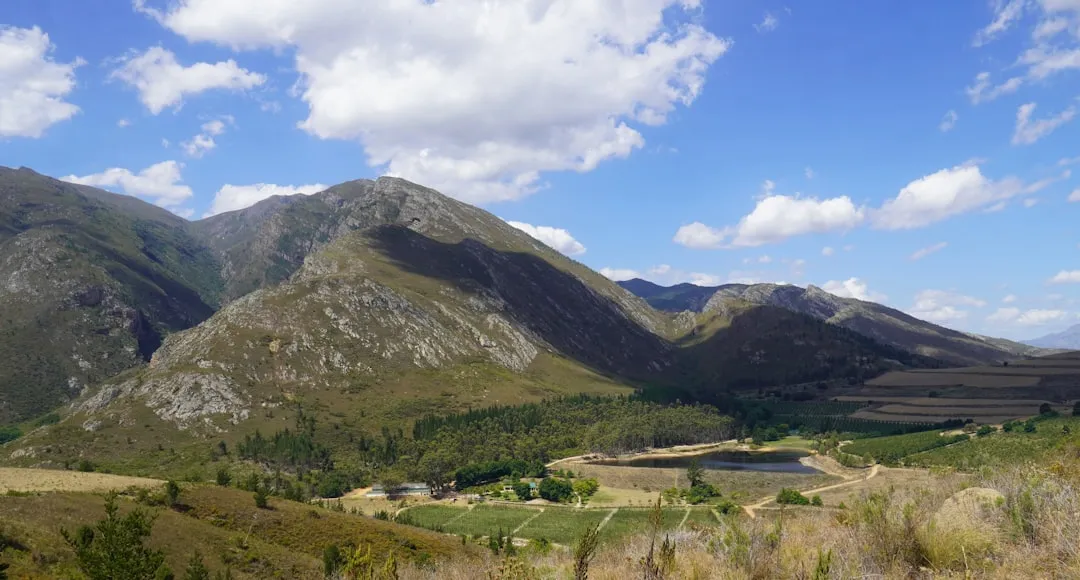
The Tsitsikamma Trail is South Africa's premier mountain wilderness experience, a 42.0 km journey that traverses the dramatic Tsitsikamma Mountains within the world-renowned Garden Route. Unlike its coastal sibling, the Otter Trail, which hugs the shoreline, the Tsitsikamma Trail ventures deep into the hinterland, offering a profound immersion into ancient indigenous forests, pristine mountain fynbos, and crystal-clear river systems. This multi-day walk is a masterclass in ecological diversity, taking hikers from the sea-level sanctuary of Nature's Valley through soaring quartzite peaks and deep, fern-filled gorges. It is a landscape defined by the Khoisan word "Tsitsikamma," meaning "place of much water," where every valley holds a secret stream and every ridge offers a panoramic view of the Indian Ocean shimmering in the distance. This is not merely a hike; it is a pilgrimage through one of the most botanically diverse regions on Earth, where the scent of wild buchu and the call of the Knysna Turaco define the sensory experience.
- Distance: 42.0 km point-to-point
- Duration: 3–6 days (flexible hut-to-hut options)
- Season: All year round (best from April to September)
- Huts: Kalander, Blaauwkrans, Keurbos, Heuningbos, Sleepkloof
- Highest point: Approximately 800 metres above sea level
- Difficulty: Moderate (requires steady fitness for river crossings and ridge climbs)
- Direction: West to East (Nature's Valley to Storms River)
Overview
The Tsitsikamma Trail offers a unique perspective on the Garden Route, elevated above the coastal plateau and tucked away from the tourist bustle of the N2 highway. The route is characterised by its "up and over" rhythm—hikers descend into deep, lush river valleys filled with ancient Outeniqua Yellowwoods and Cape Chestnut trees, only to climb back onto high ridges where the fynbos biome reigns supreme. This constant transition between the cool, damp microclimates of the forest floor and the sun-drenched, wind-swept mountain tops provides a dynamic hiking experience that never feels repetitive. The trail is well-marked but retains a sense of rugged isolation, as it passes through areas managed by both SANParks and MTO Forestry, ensuring a high standard of conservation and trail maintenance.
Geologically, the trail sits on the Table Mountain Sandstone group, which creates the dramatic, craggy skylines and the nutrient-poor soils that support the incredible floral diversity of the Cape Floral Kingdom. Hikers will encounter thousands of plant species, many of which are endemic to this specific mountain range. In the spring, the mountainsides erupt in a kaleidoscope of colours as Proteas, Ericas, and Watsonias bloom in profusion. The water in the rivers is a distinctive "tea colour," stained dark by the tannins leached from the fynbos vegetation, yet it remains some of the purest and most refreshing water found anywhere in South Africa. This water is the lifeblood of the trail, providing both a physical challenge during crossings and a spiritual sanctuary at the many swimming holes located near the overnight huts.
While the physical challenge is moderate, the emotional reward is immense. The trail is designed to be flexible; while the full route is 42.0 km, the hut system allows for shorter variations or a more leisurely pace. The sense of solitude is a primary drawcard—unlike the highly competitive Otter Trail, the Tsitsikamma Trail offers a quieter, more introspective journey. It is a place where the passage of time is measured by the movement of the sun across the peaks and the gradual change in vegetation as you move from the coastal shelf into the heart of the mountains. For those seeking to understand the true essence of the Garden Route beyond the beaches, the Tsitsikamma Trail is an essential undertaking.
History and Cultural Context
The history of the Tsitsikamma region is as deep and layered as the sandstone cliffs that define it. For millennia, the area was inhabited by the Khoisan people—the nomadic hunter-gatherers and pastoralists who were the original stewards of this land. Their presence is still felt in the names of the rivers and the archaeological sites found in coastal caves nearby. They revered the mountains as a source of water and medicinal plants, navigating the dense forests with a sophistication that modern explorers still struggle to emulate. The trail itself follows sections of ancient paths that may have been used for seasonal migrations between the coast and the interior.
In the 18th and 19th centuries, the arrival of European settlers brought a new era of exploitation and exploration. The massive indigenous forests, dominated by the majestic Outeniqua Yellowwood (Podocarpus falcatus), became a primary source of timber for the growing Cape Colony. Woodcutters lived in isolated communities within these forests, harvesting trees that were hundreds, sometimes thousands, of years old. The "Big Tree" near Storms River stands as a silent witness to this era, a survivor of the intensive logging that once threatened the entire ecosystem. The development of the Seven Passes Road and the engineering feats of Thomas Bain in the late 1800s opened the region further, but the high Tsitsikamma Mountains remained largely inaccessible and wild.
The Tsitsikamma Trail as a formal hiking route was established in the late 20th century to provide a mountain-based alternative to the coastal walks. It was a collaborative effort to showcase the inland biodiversity and to promote eco-tourism in the region. Today, the trail is managed through a partnership that emphasises the protection of the fynbos and the restoration of indigenous forest patches that were previously impacted by commercial forestry. Walking the trail today is an act of witnessing this recovery; you will pass through areas of active fynbos management and see the careful balance between commercial pine plantations on the lower slopes and the pristine wilderness of the upper peaks. The cultural heritage of the "forest people" and the ancient Khoisan remains a central theme, reminding every hiker that they are walking through a landscape with a long and complex human story.
Want more background? Read extended notes on history and cultural context → Learn more
Seasonal Highlights and Weather Reality
The Tsitsikamma region enjoys a temperate maritime climate, making the trail accessible throughout the year. However, the experience changes significantly with the seasons, and hikers should be prepared for the "four seasons in one day" phenomenon common to the South African coast. The mountains create their own weather patterns, often trapping moisture from the Indian Ocean and resulting in sudden mists or localized rain showers even when the coastal forecast is clear.
Autumn (March to May): This is arguably the best time to hike. The heat of summer begins to fade, replaced by mild, stable days and crisp evenings. The wind is generally calmer, and the clarity of the air provides the best photographic conditions for capturing the distant ocean views. Water levels in the rivers are usually manageable, making crossings easier.
Winter (June to August): Winter in the Garden Route is not as harsh as in the interior of South Africa, but it is the peak rainfall season for this region. Hikers should expect wet conditions and cold nights, with temperatures occasionally dropping towards freezing in the high mountain valleys. However, the winter rains bring the waterfalls to life, and the fynbos remains vibrant and green. This is a season for the well-equipped hiker who enjoys the moodiness of a mist-shrouded forest.
Spring (September to November): This is the botanical highlight of the year. The fynbos is in full bloom, and the mountains are alive with the activity of sunbirds and sugarbirds. The weather can be unpredictable, with "black southeasters" bringing heavy rain and wind, but the floral display is a spectacular reward for those who brave the elements. This is also the time when the indigenous forests are at their most fragrant.
Summer (December to February): Summer days can be hot and humid, with temperatures reaching 30°C or higher. The sun is intense at altitude, and there is little shade on the fynbos ridges. Early starts are essential to avoid the midday heat. The primary advantage of summer is the warmth of the river pools, which provide the perfect respite after a long day of climbing. Afternoon thunderstorms are common, providing dramatic light and a quick cooling effect.
Recommended Itinerary
4-Day Tsitsikamma Trail Itinerary
Day 1: Nature's Valley to Kalander Hut
- Distance: 5.0 km
- Elevation gain: 150 m
- Time: 1.5–2 hours
- Start at the Nature's Valley De Vasselot rest camp
- The trail begins with a gentle climb through coastal forest, offering glimpses of the Groot River lagoon
- Cross the Groot River (check tide levels if crossing near the mouth, though the trail usually stays inland)
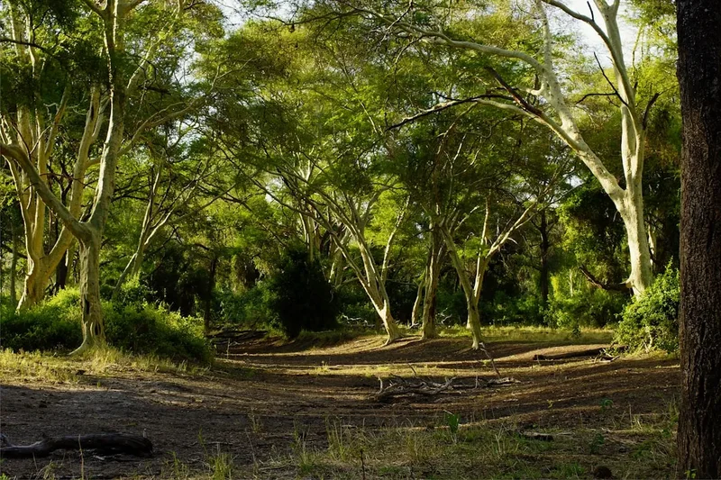
- Enter the indigenous forest where massive ferns and ancient trees provide deep shade
- Arrive at Kalander Hut, nestled in the forest near the river
- This short day is designed as a "warm-up," allowing hikers to settle into the rhythm of the trail and enjoy a swim in the river
Day 2: Kalander Hut to Blaauwkrans Hut
- Distance: 15.0 km
- Elevation gain: 450 m
- Time: 5–7 hours
- A significant increase in challenge as the trail leaves the coastal shelf
- Climb steadily onto the first major mountain ridge, entering the fynbos biome
- Spectacular views back towards Nature's Valley and the coastline
- Descend into the Blaauwkrans River valley—the most significant river crossing on the trail
- The descent is steep and requires careful footwork, especially in wet weather
- Cross the Blaauwkrans River (caution required after heavy rain)
- A final climb leads to Blaauwkrans Hut, which boasts one of the best views on the trail, overlooking the rugged gorge
Day 3: Blaauwkrans Hut to Keurbos Hut
- Distance: 12.0 km
- Elevation gain: 350 m
- Time: 4–6 hours
- The trail traverses high ridges, offering 360-degree views of the Tsitsikamma range
- Pass through sections of mountain fynbos where Proteas are particularly abundant
- Cross several smaller streams, all providing excellent drinking water
- The terrain is undulating, with several "false peaks" that test the resolve of tired legs
- Descend into a lush valley dominated by Keurbos (Virgilia oroboides) trees, which give the hut its name
- Keurbos Hut is situated in a tranquil forest setting, perfect for birdwatching
Day 4: Keurbos Hut to Storms River (Sleepkloof/Finish)
- Distance: 10.0 km
- Elevation gain: 250 m
- Time: 3–5 hours
- The final stretch takes hikers through a mix of indigenous forest and mountain plateau
- Pass through the "Valley of the Ferns," a particularly beautiful section of the trail
- The trail gradually descends towards the Storms River area
- Final views of the high peaks before entering the denser forest canopy near the finish
- The trail concludes near the Storms River Bridge (Paul Sauer Bridge) or continues to Sleepkloof Hut for those doing the 5-day version
- Celebrate the completion of the journey with a meal at the nearby village or a visit to the Storms River Mouth
Important Notes:
- The trail is point-to-point; ensure transport is organised between Nature's Valley and Storms River
- River levels can rise rapidly; always check the weather forecast for the catchment areas
- The trail is well-marked with yellow footprints, but a map is essential for navigation in mist
- Huts must be booked in advance through MTO or SANParks
- Water is generally safe to drink from mountain streams, but treatment is advised near huts
Planning and Bookings
Book Your Trip
Everything you need to plan your journey
Accommodation
Find places to stay near Plettenberg Bay
Flights
Search flights to Plettenberg Bay
Essential Preparation
The Tsitsikamma Trail requires a moderate level of physical fitness and careful logistical planning. Because it is a point-to-point trail, the most critical preparation involves transport. Most hikers fly into George Airport (GRJ) and rent a car or arrange a shuttle to Nature's Valley. It is common practice to leave a vehicle at the finish point (Storms River) and use a local shuttle service to reach the start at Nature's Valley. This ensures your transport is waiting for you when you finish.
Preparation should also include "hill training" with a weighted pack. While the elevations are not extreme by global standards, the repetitive climbing and descending into river valleys can be taxing on the knees and calves. Hikers should be comfortable carrying a 12–15 kg pack for up to 7 hours a day. Additionally, basic knowledge of river crossing safety is essential, as the Blaauwkrans River can become a significant obstacle during the rainy season.
Trail Accommodation
The trail features five overnight huts: Kalander, Blaauwkrans, Keurbos, Heuningbos, and Sleepkloof. These huts are rustic but well-maintained, providing a comfortable refuge in the wilderness. Each hut typically consists of two or three rooms with wooden bunks and a central lapa (covered social area) for cooking and socialising.
Hut Facilities:
- Wooden bunks with basic mattresses (no bedding provided)
- Rainwater tanks (usually reliable, but conserve water during dry spells)
- Braai (barbecue) pits with wood often provided (check current fire restrictions)
- Basic pit or composting toilets
- Cold water showers (at some huts, though river swimming is the preferred method)
- No electricity or mobile phone charging points
- Enclosed sleeping areas to protect from wind and rain
What Huts Don't Provide:
- Food, snacks, or beverages
- Cooking utensils, pots, pans, or cutlery
- Gas stoves or fuel
- Bedding, pillows, or towels
- Lighting (bring a head torch)
Booking Requirements:
- Bookings are managed by MTO Forestry (Mountain to Ocean)
- It is recommended to book at least 3–6 months in advance, especially for peak periods (December and Easter)
- Costs are approximately R150–R200 per person per night (subject to change)
- A minimum of two hikers is required for safety reasons; solo hiking is generally discouraged
Required Gear
- Hiking boots: Must be well broken-in with excellent ankle support and grip for slippery river rocks
- Backpack: 50–65L capacity with a high-quality harness and rain cover
- Waterproof jacket: A breathable, high-quality shell is essential for the unpredictable mountain weather
- Sleeping bag: 3-season rating (comfort level 0°C to 5°C) is sufficient for most of the year
- Head torch: Essential for hut life and emergency navigation, with spare batteries
- First aid kit: Include blister plasters, antiseptic, rehydration salts, and any personal medication
- Navigation: A physical map of the trail and a compass or GPS device with offline maps
- Whistle and signal mirror: For emergency signaling in deep valleys
- Dry bags: To keep clothing and sleeping bags dry during river crossings and rain
What to Bring
- Food: Lightweight, high-calorie meals for the duration of the hike (dehydrated meals, nuts, dried fruit, biltong)
- Cooking system: Lightweight gas stove and sufficient fuel (huts do not have stoves)
- Water treatment: Chlorine tablets or a portable filter (while mountain water is generally clean, treatment is safer)
- Sun protection: SPF 50+ sunscreen, wide-brimmed hat, and UV-rated sunglasses
- Clothing: Moisture-wicking base layers, a fleece or down mid-layer, and quick-drying hiking trousers
- Toiletries: Biodegradable soap, toothbrush, small towel, and toilet paper (pack out used paper)
- Insect repellent: To guard against ticks and mosquitoes, especially in the forest sections
- Power bank: To keep your phone/GPS charged for emergency use
- Cash: For shuttles and small purchases in Nature's Valley or Storms River
Permits
Permits for the Tsitsikamma Trail are mandatory and are issued as part of the hut booking process. Unlike some national parks where you can buy a day permit at the gate, the multi-day Tsitsikamma Trail requires a confirmed reservation for the overnight huts. The trail is managed by MTO Forestry, and they handle the administration and permit issuance.
Booking Process:
- Visit the MTO Eco-Tourism website or contact their booking office via email
- Select your start date and the number of nights/huts you wish to book
- Full payment is required to secure the permit
- Once paid, you will receive a permit document which must be carried with you at all times on the trail
- You may be asked to present your permit at the start (Nature's Valley) or by rangers on the trail
Costs and Regulations:
- Permit fees are bundled with hut costs, making it a straightforward per-night fee
- Group sizes are limited to ensure the wilderness character of the trail is maintained (usually a maximum of 12 people per hut)
- Hikers must sign an indemnity form before starting the trail
- The permit is only valid for the specific dates and huts booked; "wild camping" between huts is strictly prohibited to protect the fynbos
Cancellations and Changes: MTO has a specific cancellation policy. Generally, cancellations made more than 30 days in advance may receive a partial refund, but last-minute cancellations due to weather are usually not refunded unless the trail is officially closed by the authorities. It is highly recommended to have travel insurance that covers hiking activities.
Other Activities in the Area
The Garden Route is South Africa's adventure capital. Consider these activities to complement your hike:
- The Otter Trail: If you can secure a booking, this world-famous coastal trail is the perfect companion to the Tsitsikamma Trail, offering a completely different ecological experience.
- Bloukrans Bridge Bungee: Located near the trail, this is the world's highest commercial bridge bungee jump (216 metres). A must for adrenaline junkies.
- Tsitsikamma Canopy Tour: Experience the indigenous forest from the perspective of the birds, ziplining between platforms built into giant Yellowwood trees.
- Storms River Mouth: Visit the suspension bridges, go kayaking up the Storms River gorge, or take a boat trip to see the dramatic coastline from the water.
- Nature's Valley Beach: Spend a day relaxing on one of South Africa's most beautiful and secluded beaches, or hike the short Salt River mouth trail.
- Plettenberg Bay: A short drive away, offering whale watching (seasonal), swimming with seals, and world-class dining.
- Birds of Eden and Monkeyland: Exceptional wildlife sanctuaries located in the Crags, near Nature's Valley, focusing on the rehabilitation of birds and primates.
Safety and Conditions
River Crossings: The most significant safety hazard on the Tsitsikamma Trail is the river crossings, particularly the Blaauwkrans River. After heavy rain, these rivers can become impassable torrents. Never attempt to cross a river if the water is above mid-thigh level or if the current is too strong to stand steadily. If in doubt, wait for the water level to drop (which often happens within a few hours after rain stops) or backtrack to the previous hut. Always unclip your backpack's waist belt when crossing deep water so you can jettison the pack if you fall.
Weather Extremes: Hypothermia is a genuine risk in winter or during sudden mountain storms. Even in summer, a wet hiker in a cold wind can quickly lose body heat. Always carry a high-quality waterproof jacket and a warm layer, regardless of the morning forecast. Conversely, heat exhaustion is a risk in summer; carry at least 2–3 litres of water and wear a hat.
Wildlife: While the trail is home to leopards, they are extremely elusive and pose no threat to hikers. The more common concerns are baboons and snakes. Baboons are generally shy but can be attracted to food; never leave food unattended outside the huts. Snakes, such as the Puff Adder and Cape Cobra, are present but will usually move away if they hear you coming. Watch where you step, especially in long grass or on sunny rocks. Carry a pressure bandage and know basic snakebite first aid.
Emergency Communication: Mobile phone reception is extremely spotty and non-existent in the deep valleys. Do not rely on your phone for emergencies. It is highly recommended to carry a Personal Locator Beacon (PLB) or a satellite communication device (like a Garmin inReach). Always leave your detailed itinerary with a reliable contact person who knows when to expect you back.
Fire Safety: The fynbos is highly flammable. Fires are only permitted in the designated braai pits at the huts. Never smoke while walking and ensure all cooking stoves are used on stable, non-flammable surfaces. During periods of high fire danger, all fires may be prohibited.
Side Trips and Points of Interest
The Big Tree: While not directly on the trail, this 800-year-old Outeniqua Yellowwood is located near the Storms River finish. Standing 36 metres tall with a trunk circumference of 9 metres, it is a humbling reminder of the forest's ancient past. It is easily accessible via a short boardwalk and is a worthy post-hike pilgrimage.
Blaauwkrans River Pools: On Day 2, take the time to explore the river upstream or downstream from the crossing point. There are several deep, amber-coloured pools perfect for swimming. The quartzite cliffs surrounding the river create a dramatic, cathedral-like atmosphere that is one of the highlights of the entire trail.
Fynbos Ridge Viewpoints: On Day 3, there are several unnamed rocky outcrops along the high ridges. Taking ten minutes to scramble up these provides an uninterrupted view of the Peak Formosa (the highest point in the Tsitsikamma range at 1,675 m) to the north and the vast expanse of the Indian Ocean to the south. On a clear day, you can see the coastline stretching all the way to Robberg Nature Reserve in Plettenberg Bay.
Valley of the Ferns: This section on the final day is a botanical wonderland. The density and variety of ferns—from the delicate Maidenhair to the massive Tree Ferns—create a prehistoric landscape. It is a quiet, damp, and incredibly peaceful part of the trail that rewards slow walking and careful observation.
Leave No Trace
The Tsitsikamma Mountains are a fragile ecosystem. The fynbos, in particular, is sensitive to trampling and soil erosion. As a hiker, you are a guest in this wilderness, and your goal should be to leave no evidence of your passage. The "Leave No Trace" principles are not just guidelines; they are essential for the long-term survival of this trail.
Core Principles for the Tsitsikamma Trail:
- Plan Ahead and Prepare: Know the regulations and special concerns of the area. Prepare for extreme weather and emergencies to avoid needing rescue, which can damage the environment.
- Travel and Camp on Durable Surfaces: Stay on the marked trail at all times. Do not take shortcuts on switchbacks, as this causes severe erosion during heavy rains. Only use the designated huts for overnight stays.
- Dispose of Waste Properly: Pack out everything you pack in. This includes all food scraps (even "biodegradable" ones like orange peels, which don't belong in this ecosystem), micro-trash, and hygiene products. Use the toilets at the huts; if you must go between huts, bury human waste in a "cathole" at least 15 cm deep and 60 metres from any water source. Pack out your toilet paper.
- Leave What You Find: Do not pick flowers, especially the Proteas and Ericas. Do not remove rocks, plants, or cultural artifacts. Take photos, not specimens.
- Minimise Campfire Impacts: Only use the provided braai pits at huts. Use wood sparingly and ensure the fire is completely extinguished before going to bed or leaving the hut.
- Respect Wildlife: Observe animals from a distance. Never feed baboons or birds, as this leads to habituation and eventual conflict.
- Be Considerate of Others: Respect the silence of the wilderness. Keep noise levels down at the huts and allow the sounds of nature to prevail.