Trolltunga Hike - The Troll's Tongue of the Hardangerfjord
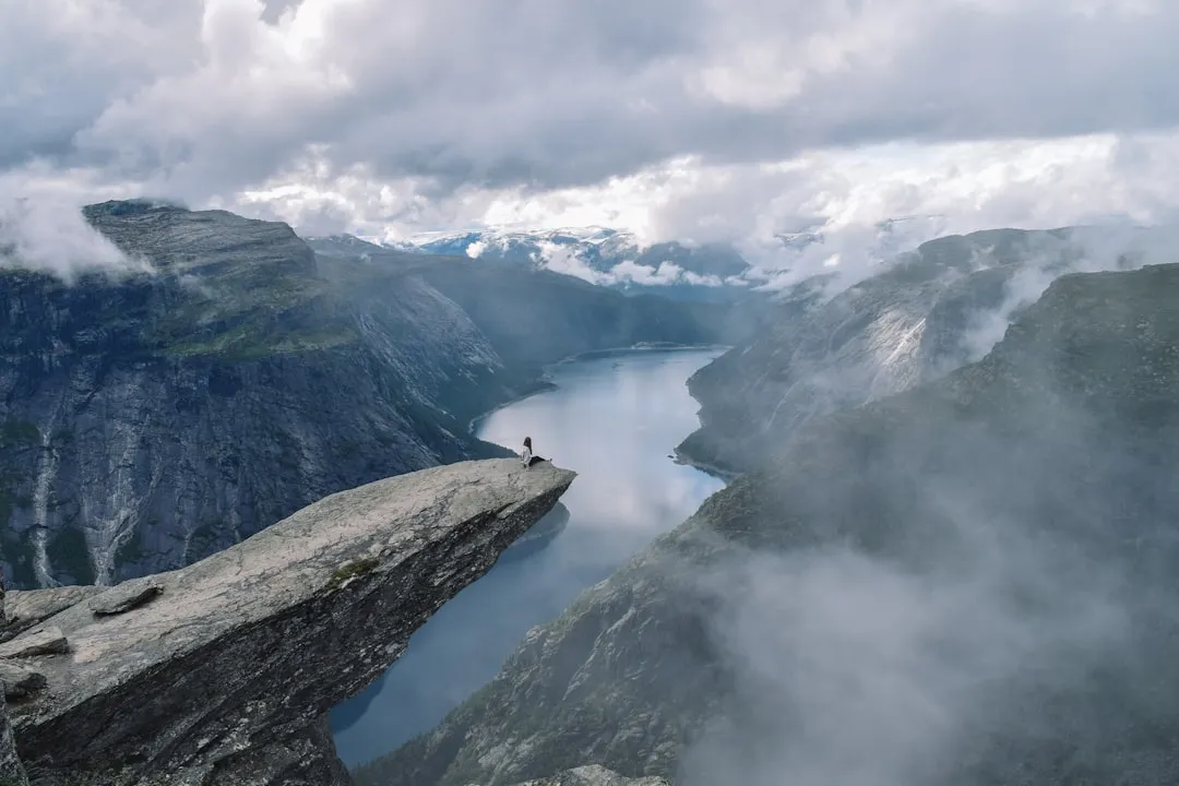
Trolltunga, or "The Troll's Tongue," is arguably Norway's most iconic and breathtaking rock formation. Perched precariously 1,100 metres above sea level and hovering 700 metres over the turquoise waters of Lake Ringedalsvatnet, this horizontal granite slab offers a perspective of the Norwegian wilderness that is both humbling and exhilarating. Located on the western edge of the Hardangervidda plateau—the largest mountain plateau in Northern Europe—the hike to Trolltunga is not merely a walk but a pilgrimage for outdoor enthusiasts from across the globe. It is a journey through a landscape carved by ancient glaciers, where sheer cliffs meet deep fjords and the weather can shift from radiant sunshine to alpine gales in a matter of minutes. This is a challenging day walk that demands physical stamina, mental fortitude, and meticulous preparation, rewarding those who complete it with a view that has come to symbolise the raw, untamed beauty of Scandinavia.
- Distance: 28.0 km return (from P2 Skjeggedal) or 20.0 km return (from P3 Mågelitopp)
- Duration: 10–12 hours (return)
- Season: Mid-June to mid-September (independent); October to May (strictly guided with snowshoes/skis)
- Elevation Gain: 900 m (from P2) or 320 m (from P3)
- Highest Point: 1,180 m above sea level
- Difficulty: Challenging / Expert
- Closest City: Odda (13 km from trailhead)
Overview
The Trolltunga hike is a masterclass in Norwegian alpine terrain. It is a long, demanding trek that tests the endurance of even seasoned hikers. The route begins in the valley of Skjeggedal and ascends rapidly onto the high mountain plateau, traversing a landscape of polished granite, scattered boulders, and crystal-clear meltwater streams. Unlike many other famous Norwegian hikes that offer a quick ascent to a viewpoint, Trolltunga requires a sustained effort over a significant distance. The 28-kilometre round trip from the main parking area at Skjeggedal involves a total ascent of nearly 1,000 metres, much of which is concentrated in the first few kilometres of the journey.
The landscape is defined by the massive Ringedalsvatnet lake, a reservoir that sits deep within a glacial trough. As you walk along the northern rim of this canyon, the views evolve from lush valley greenery to the stark, minimalist beauty of the high tundra. The vegetation is sparse—mostly mosses, lichens, and hardy alpine shrubs—allowing the geological features of the Hardangervidda to take centre stage. The rock itself, Trolltunga, was formed during the last ice age, approximately 10,000 years ago, when glacial meltwater froze in the crevices of the mountain and eventually broke off large chunks of rock, leaving the thin, protruding tongue we see today.
In recent years, the popularity of Trolltunga has surged, largely driven by its visual impact on social media. However, the "Instagrammable" nature of the summit should not detract from the seriousness of the undertaking. This is a high-altitude environment where the temperature can be 10 degrees Celsius lower than in the valley below, and where mist can roll in with disorienting speed. The hike is a test of pacing; the final kilometres on the return journey often prove the most difficult as fatigue sets in. Yet, standing on the edge of the "Tongue," with the vast expanse of the Folgefonna glacier visible in the distance and the lake shimmering far below, provides a sense of accomplishment that few other trails can match. It is a quintessential Norwegian experience: rugged, beautiful, and uncompromising.
History and Cultural Context
The history of the Trolltunga region is inextricably linked to Norway's industrial development and its relationship with water power. Long before it became a global hiking destination, the Skjeggedal valley was a hub for hydroelectric engineering. In the early 20th century, the construction of the Ringedalsdammen—a massive gravity dam built between 1910 and 1918—transformed the local landscape. The dam was a feat of engineering for its time, designed to provide power to the smelting plants in the nearby town of Odda, which was then a burgeoning industrial centre. The granite blocks used to build the dam were quarried from the surrounding mountains, and the remnants of this industrial heritage, including old stone houses and transport tracks, can still be seen today.
For decades, the primary way to reach the high plateau was via the Mågelibanen, an industrial funicular railway built in 1911 to transport workers and equipment up the steep mountainside. While the funicular is no longer in operation for the public, its path remains a landmark on the trail. For much of the 20th century, Trolltunga remained a local secret, visited only by hardy mountaineers and workers from the power plants. It wasn't until the early 2010s that the trail saw a dramatic increase in international visitors. In 2010, fewer than 1,000 people made the trek; by 2019, that number had exceeded 80,000 annually.
Culturally, the name "Trolltunga" reflects the deep-seated presence of folklore in the Norwegian psyche. Trolls are central figures in Scandinavian mythology, often depicted as ancient, stone-like creatures that turn to rock when exposed to sunlight. The idea of a "Troll's Tongue" protruding from the mountain fits perfectly into this narrative of a landscape inhabited by giants. Today, the trail is managed with a focus on sustainability and safety, balancing the preservation of the wilderness with the needs of the thousands of hikers who come to experience this legendary piece of Norwegian folklore.
Want more background? Read extended notes on history and cultural context → Learn more
Seasonal Highlights and Weather Reality
The hiking season for Trolltunga is strictly dictated by the snowmelt and the onset of winter. Because of its elevation and northern latitude, the trail is covered in deep snow for the majority of the year. Attempting the hike outside the recommended windows without professional guidance is extremely dangerous and often results in emergency rescues.
Summer (Mid-June to August): This is the peak season. The snow has usually retreated from the main path, though patches may remain in shaded gullies until July. The days are incredibly long—in late June, the sun barely sets, providing ample daylight for the 12-hour trek. However, this is also the busiest time, and queues for photos on the rock can exceed two hours. Temperatures typically range from 8°C to 18°C, but can drop toward freezing if a storm moves in.
Autumn (September): September offers a different kind of beauty, with the alpine vegetation turning shades of deep red and gold. The air is crisper, and the crowds begin to thin. However, the days shorten rapidly, and the risk of early snowfall increases. By mid-September, the window for independent hiking usually closes as the first winter storms arrive.
Winter and Spring (October to early June): During these months, the trail is an advanced alpine environment. The path is invisible under metres of snow, and the risk of avalanches is real. Independent hiking is strongly discouraged and often prohibited by local authorities. Guided tours using snowshoes or skis are available from February onwards, offering a serene, white-washed version of the landscape, but these require a high level of physical fitness and specialised equipment.
Regardless of the season, the "Weather Reality" of Trolltunga is that it is unpredictable. The Hardanger region is known for its high precipitation. It is common to start the hike in sunshine and finish in a torrential downpour. Wind speeds on the plateau can be significantly higher than in Odda, making the cliff edges particularly hazardous. Always check the mountain-specific forecast (yr.no) before setting out.
Recommended Itinerary
Standard Day Hike Itinerary (from P2 Skjeggedal)
Early Morning: The Ascent (06:00 – 09:00)
- Start at the P2 Skjeggedal parking area no later than 07:00.
- The first 4 km are the most demanding, involving a steep climb of approximately 400 m.
- You can choose to walk up the paved switchback road (built to replace the old funicular route) or take the shuttle bus to P3 Mågelitopp to save 3.5 km and 3 hours of walking.
- Reach Mågelitopp (the top of the first climb) and take a moment to catch your breath. The terrain flattens out slightly here as you enter the high mountain valley.
- Pass through the "Gryteskar" pass, where the trail winds through large boulders and small alpine ponds.
Morning: The High Plateau (09:00 – 12:00)
- The trail continues with a series of moderate climbs and descents across the plateau.
- Distance: Approximately 6 km from Mågelitopp to the halfway mark.
- Pass the "Potholes" (Jettegrytene), natural circular depressions in the rock formed by glacial erosion.
- Enjoy the first expansive views of Lake Ringedalsvatnet to your right. The scale of the canyon begins to reveal itself.
- Cross several small streams (usually manageable via stepping stones or small bridges). This is a good area to refill water bottles from the running meltwater.
Midday: The Destination (12:00 – 14:00)
- The final 3 km to Trolltunga involve a gradual ascent across polished granite slabs.
- Arrive at Trolltunga. If you are there during peak season, join the organised queue for photos.
- Take time to explore the surrounding cliffs (carefully). There are several other viewpoints nearby that offer spectacular perspectives of the "Tongue" without the crowds.
- Eat a substantial lunch. You are 14 km from your starting point and will need the energy for the return journey.
- Note the emergency shelter located near the 13 km mark—this is for emergency use only, not for overnight stays.
Afternoon: The Return (14:00 – 18:30)
- Begin the 14 km return journey along the same path.
- The return can be deceptively tiring; many injuries occur during the final descent when legs are fatigued.
- Pay close attention to the red "T" markers painted on rocks. In mist, it is easy to lose the trail on the granite sections.
- Descend from Mågelitopp back to Skjeggedal. If you have pre-booked the shuttle down, ensure you know the last departure time.
- Arrive back at P2 Skjeggedal, where you can find basic facilities and transport back to Tyssedal or Odda.
Important Notes:
- Total walking time is typically 10–12 hours. Do not underestimate the distance.
- There are no rubbish bins on the trail; everything you bring must be carried back out.
- Drones are prohibited in certain areas to protect the peace of the national park and the safety of other hikers.
- Cell phone coverage is intermittent; do not rely on it for navigation.
Planning and Bookings
Book Your Trip
Everything you need to plan your journey
Accommodation
Find places to stay near Odda
Flights
Search flights to Odda
Essential Preparation
The Trolltunga hike requires a high level of physical fitness. You should be comfortable walking for 10–12 hours on uneven, rocky terrain with significant elevation changes. Preparation should begin weeks in advance with cardiovascular training and hill walking. Logistics are equally important; the trailhead is located in Skjeggedal, near the town of Odda. Most hikers base themselves in Odda or Tyssedal the night before and after the hike.
Booking your transport and parking is critical. If you plan to drive, parking at P2 (Skjeggedal) or P3 (Mågelitopp) must be booked online well in advance, as spaces are extremely limited. P3 parking, in particular, often sells out months ahead. If you do not have a parking reservation, you must use the shuttle buses that run from Odda and Tyssedal. Ensure you have downloaded offline maps (such as Norgeskart or UT.no) as the trail can be difficult to follow in poor visibility.
Trail Accommodation
Trolltunga is primarily a day hike, and there are no huts or lodges directly on the trail that provide overnight accommodation for independent hikers. The emergency shelters found along the route are strictly for life-threatening situations and do not contain beds or facilities.
Accommodation Options:
- Odda and Tyssedal: These are the primary hubs. Options range from the historic Tyssedal Hotel to various guesthouses, hostels, and campsites (e.g., Odda Camping).
- Camping: Wild camping is permitted on the Hardangervidda plateau under the Norwegian "Allemannsretten" (Right of Access) laws. However, you must camp at least 150 metres away from inhabited houses and avoid the immediate vicinity of the Trolltunga rock itself to protect the environment. Be aware that the plateau is very exposed to wind and cold.
- Glamping/Guided Stays: Some local tour operators offer "Arctic Dome" stays or guided overnight treks where they provide pre-pitched tents and meals. These must be booked as part of a guided package.
Required Gear
- Hiking Boots: Sturdy, waterproof boots with good ankle support are non-negotiable. The terrain is rocky and often muddy.
- Clothing Layers: Use the layering principle. A moisture-wicking base layer (merino wool is best), an insulating mid-layer (fleece or wool), and a high-quality waterproof and windproof shell jacket.
- Trousers: Quick-drying hiking trousers. Avoid denim, which becomes heavy and cold when wet.
- Navigation: A physical map and compass, plus a GPS or smartphone with offline maps and a power bank.
- Headlamp: Essential if you start early or are delayed, even in summer.
- First Aid Kit: Including blister plasters (Compeed), bandages, and any personal medication.
- Whistle: For signalling in case of emergency or low visibility.
What to Bring
- Food: High-energy snacks (nuts, chocolate, energy bars) and a substantial lunch. You will burn a significant number of calories.
- Water: At least 2 litres of water. While there are streams on the plateau where you can refill, ensure the water is running and clear. In late summer, some smaller streams may dry up.
- Sun Protection: Sunscreen, sunglasses, and a hat. The sun is very strong at high altitudes, even on cool days.
- Warm Accessories: A beanie and gloves, even in July. The wind on the plateau can be biting.
- Rubbish Bag: To carry out all your waste, including fruit peels and tissues.
Permits
Currently, no permit is required to hike to Trolltunga. However, the management of the trail relies on a "traffic light" system and parking regulations to ensure safety and environmental protection. While you don't need a ticket to walk, you do need to plan for the costs associated with parking and transport, which act as a de facto access management system.
Parking Tiers and Costs:
- P1 Tyssedal: Located in the valley. Best for those taking the shuttle bus. Cost: Approx. 300 NOK per day.
- P2 Skjeggedal: The main trailhead. 180 spaces available. Cost: Approx. 500 NOK per day. This is where the 28 km hike begins.
- P3 Mågelitopp: The highest parking lot, privately owned. Only 30 spaces. Cost: Approx. 600 NOK per day. Booking this saves you the hardest 800 m of elevation gain and 7 km of walking.
Shuttle Buses: For most hikers, the shuttle bus from Odda or Tyssedal to P2 is the most convenient option. These run frequently during the summer season (June–September). Prices are approximately 250–300 NOK return. There is also a separate shuttle that runs between P2 and P3 for those who want to skip the first steep climb but couldn't secure a P3 parking spot.
Registration: While not a formal permit, hikers are encouraged to check in with the "Mountain Rangers" at the P2 trailhead. They provide up-to-date weather briefings and check that hikers have adequate gear. If they advise against hiking due to weather, it is strongly recommended to follow their guidance.
Other Activities in the Area
The Hardanger region is one of Norway's most diverse outdoor playgrounds. Consider these activities to round out your trip:
- Via Ferrata Trolltunga: For a more adrenaline-fueled approach, you can climb the mountain face via a guided Via Ferrata route. This involves cycling along Lake Ringedalsvatnet, climbing a 250-metre ladder up the rock face, and then hiking the final stretch to the Tongue.
- Buer Glacier: Located just outside Odda, this is a shorter but very scenic hike to the edge of the Buerbreen glacier, an arm of the massive Folgefonna glacier.
- Hardangerfjord Cruises: Relax your legs on a boat tour of the Hardangerfjord, famous for its fruit orchards and dramatic waterfalls like Vøringsfossen.
- Cider Tasting in Lofthus: The Hardanger region is the "Cider Capital" of Norway. Visit local farms to sample world-class apple cider produced from the orchards lining the fjord.
- Låtefossen Waterfall: A spectacular "twin" waterfall located right next to Route 13, south of Odda. The spray from the falls often soaks the road.
Safety and Conditions
The Mountain Code (Fjellvettreglene): Norwegians live by a set of nine rules for mountain safety. Key among these are: "Plan your trip and inform others where you are going," "Adjust your plans according to your abilities and the conditions," and "Do not be ashamed to turn back."
Weather Hazards: The most common cause of rescues at Trolltunga is exhaustion combined with poor weather. Hypothermia can occur even in summer if you get wet and the wind picks up. If the mist becomes so thick that you cannot see the next red "T" marker, stop and wait for it to clear or use your GPS to carefully backtrack. Never attempt to find a "shortcut" off the plateau; the cliffs are sheer and unforgiving.
The Cliff Edge: Trolltunga has no safety railings. While the rock itself is solid granite, the surrounding edges can be slippery when wet or icy. Every year, thousands of people pose for photos on the edge. Exercise extreme caution, especially if it is windy. Do not engage in risky behaviour for the sake of a photograph.
Rescue Services: The Norwegian Red Cross and local volunteer rescue teams operate in the area. However, a helicopter rescue is only possible in certain weather conditions. If you are injured, it may take many hours for a ground team to reach you. Always carry an emergency bivvy bag or space blanket to stay warm while waiting for help.
Physical Limits: Many hikers find the return journey harder than the ascent. Knee pain is common on the final descent into Skjeggedal. Use trekking poles to reduce the impact on your joints and ensure you have saved enough water and food for the final three hours of the trek.
Side Trips and Points of Interest
The Potholes (Jettegrytene): Located a few kilometres into the hike, these geological wonders are perfectly circular holes worn into the solid rock by swirling water and stones during the glacial retreat. They are fascinating examples of the power of erosion and make for a great short break spot.
Ringedalsdammen: Before you start your hike at P2, take a moment to look at the dam. It is one of the largest of its kind in Europe and a testament to early 20th-century masonry. The walk across the top of the dam (when open) offers a great view of the valley you are about to climb out of.
Preikestolen and Kjeragbolten Comparison: Many hikers compare Trolltunga to Norway's other "Big Three" hikes. While Preikestolen (Pulpit Rock) is shorter and easier, and Kjeragbolten is more technical, Trolltunga is widely considered the most physically demanding due to its sheer length. If you have completed the others, expect Trolltunga to take significantly more out of you.
The "Mini-Tongue": Just a few hundred metres before you reach the main Trolltunga, there is a smaller rock protrusion that looks similar but is much closer to the ground. It’s a great place for a "warm-up" photo and is often completely ignored by the crowds heading for the main event.
Leave No Trace
The surge in tourism at Trolltunga has put immense pressure on the local environment. As a visitor, you have a responsibility to minimise your impact on this fragile alpine ecosystem. The soil at this altitude is thin, and vegetation takes years to recover from being trampled.
Leave No Trace Principles:
- Waste Management: There are no bins. Carry out all rubbish, including organic waste like banana skins or apple cores, which do not decompose quickly in the cold alpine climate and can harm local wildlife.
- Human Waste: Use the toilets at the trailheads (P2 and P3) before you start. If you must go on the trail, move at least 50 metres from the path and water sources, dig a small hole, and carry out your toilet paper in a sealed bag.
- Stay on the Path: Follow the red "T" markers. Braiding the trail (creating multiple side paths) causes erosion and destroys the mosses and lichens that hold the soil together.
- Respect Wildlife: You may encounter reindeer or birds like the ptarmigan. Observe them from a distance and never attempt to feed them.
- Water Purity: Do not wash yourself or your dishes directly in the alpine lakes or streams. Use a container to collect water and wash at least 30 metres away from the source using biodegradable soap.