Transfăgărășan Ridge Traverse
The Transfăgărășan Ridge Traverse is a challenging, multi-day trek through the heart of Romania's Southern Carpathians, specifically the Făgăraș Mountains. This route follows the dramatic crest of the Făgăraș range, often referred to as the "Transylvanian Alps," offering unparalleled panoramic views and a true alpine experience. The traverse is renowned for its rugged terrain, high-altitude glacial lakes, and the sheer scale of its granite peaks. It is a journey that demands significant physical fitness, excellent navigation skills, and a deep respect for the mountain environment. Unlike more manicured trails, this route often involves scrambling, route-finding, and exposure, making it a rewarding adventure for experienced mountaineers and hikers seeking a wild and remote experience in Europe.
- Distance: Approximately 70 km
- Duration: 5–7 days
- Season: July–September (snow-free conditions are essential)
- Difficulty: Challenging to Very Challenging
- Highest point: Moldoveanu Peak (2,544 m)
- Access: Balea Lac via Transfăgărășan Highway (DN7C)
- Permits: Generally not required for hiking, but check local regulations
- Country: Romania
Overview
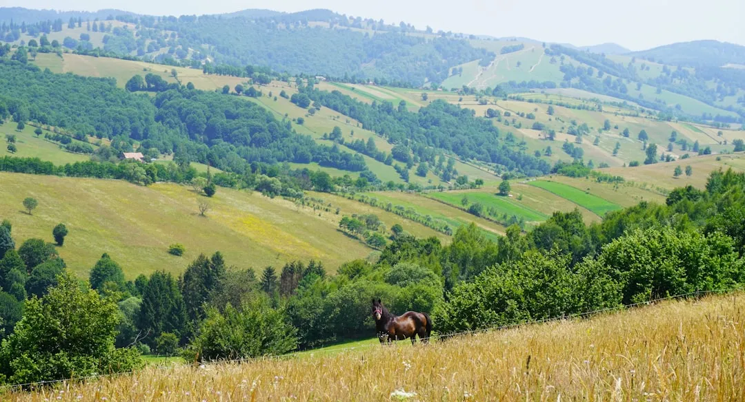
The Transfăgărășan Ridge Traverse is a spectacular high-altitude trek that traces the main ridge of the Făgăraș Mountains, Romania's highest and most formidable range. This route is not a single, well-marked path but rather a series of interconnected trails, cairns, and sometimes faint tracks that follow the dramatic ridgeline. The traverse begins at Balea Lac, a stunning glacial lake accessible via the famous Transfăgărășan Highway (DN7C), and typically concludes near the town of Curtea de Argeș or another accessible point after descending from the mountains. The journey is characterised by its relentless ups and downs, traversing numerous peaks and saddles, each offering a new vista of the surrounding alpine landscape.
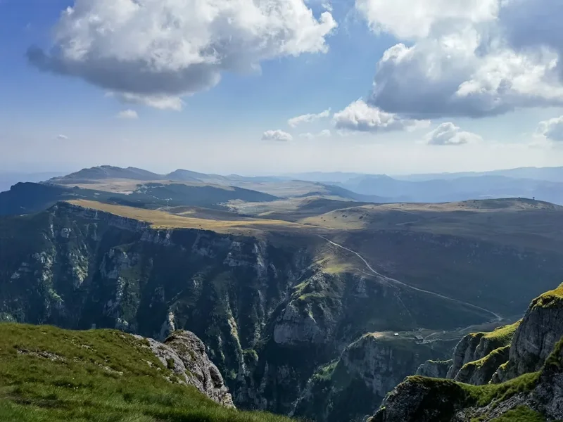
The Făgăraș Mountains are a geological marvel, sculpted by ancient glaciers. Evidence of this glacial past is abundant, with U-shaped valleys, cirques, and numerous glacial lakes (called "bâlti" or "ochiuri" in Romanian) dotting the landscape. The highest peak, Moldoveanu Peak (2,544 m), is a significant milestone for any trekker completing the traverse. The terrain is predominantly rocky, with scree slopes, boulder fields, and sections requiring hands-on scrambling. The weather in the Făgăraș can be highly unpredictable, with rapid changes from sunshine to storms, fog, and even snow, even in mid-summer. This necessitates careful planning, robust gear, and a high degree of self-sufficiency.
The route offers a profound sense of wilderness and isolation. While Balea Lac can be busy during the summer months when the Transfăgărășan Highway is open, venturing onto the ridge quickly leads to solitude. Hikers will encounter few other people, especially on the more remote sections. The flora and fauna are typical of high alpine environments, with hardy wildflowers in summer and the possibility of spotting chamois or marmots. The traverse is a true test of endurance and navigation, rewarding those who undertake it with an unforgettable experience of raw, untamed mountain beauty.
History and Cultural Context
The Făgăraș Mountains have a long history of human interaction, primarily driven by pastoralism and, more recently, mountaineering. For centuries, shepherds have led their flocks to the high mountain pastures (called "poieni" or "izlazuri") during the summer months. These traditional practices have shaped the landscape and left behind a legacy of shepherd huts and trails, though many are now in disrepair. The high pastures, particularly around Balea Lac, were once vibrant centres of seasonal life, with shepherds producing cheese and other dairy products.
The Făgăraș range gained significant attention in the mid-20th century with the construction of the Transfăgărășan Highway (DN7C). This ambitious engineering project, initiated by Nicolae Ceaușescu, was intended as a strategic military route to cross the Southern Carpathians. Built between 1970 and 1974, it is one of the highest and most spectacular roads in Romania, winding its way up to Balea Lac. While its military purpose was questionable, its impact on tourism and access to the mountains has been immense. The highway's opening each summer (typically June to October, weather permitting) provides the primary access point for trekkers to the Făgăraș ridge.
The development of mountaineering and trekking in the Făgăraș gained momentum in the latter half of the 20th century. Mountaineering clubs and enthusiasts began to map out and explore the ridge, establishing routes and documenting the challenging terrain. The Făgăraș Mountains are now a premier destination for Romanian and international hikers and climbers, attracting those seeking a genuine alpine challenge. Despite the highway's presence, much of the ridge remains wild and remote, preserving its character as a formidable mountain wilderness.
Seasonal Highlights and Weather Reality
The Făgăraș Mountains present a starkly different character depending on the season, with the summer months offering the only viable window for the Transfăgărășan Ridge Traverse.
Summer (July–September): This is the prime season for the traverse. The snow generally recedes from the higher passes and peaks by early July, making the trails passable. The days are longer, providing ample daylight for hiking. Wildflowers bloom profusely in the alpine meadows, creating a vibrant spectacle. However, summer also brings the highest risk of thunderstorms, which can develop rapidly and pose a serious danger on exposed ridges. Temperatures can vary significantly, from pleasant during the day to near freezing at night, especially at higher elevations. Fog can also descend quickly, severely reducing visibility and making navigation difficult.
Spring (April–June): Early spring is still very much a winter environment in the Făgăraș. Snowpack remains deep, and avalanche risk is high. The Transfăgărășan Highway is typically closed until late June. While experienced mountaineers might attempt some ascents, the ridge traverse is generally not feasible or safe until the snow has melted significantly.
Autumn (October–November): As autumn progresses, temperatures drop, and the first snowfalls can occur as early as October. The Transfăgărășan Highway usually closes by late October or early November. While early autumn can offer crisp, clear days and beautiful colours, the increasing likelihood of snow, ice, and shorter daylight hours makes the ridge traverse increasingly hazardous and less predictable. Navigation becomes more challenging with potential snow cover.
Winter (December–March): The Făgăraș Mountains are a serious winter mountaineering destination during this period. Deep snow, extreme cold, high winds, and significant avalanche risk make the ridge traverse impossible for standard hiking. Only highly experienced winter mountaineers with appropriate equipment (skis, snowshoes, ice axes, crampons) and knowledge of avalanche safety would consider venturing into the range.
Recommended Itinerary
5-Day Transfăgărășan Ridge Traverse Itinerary
Day 1: Balea Lac to Refugiu Căldare (or nearby bivouac spot)
- Distance: Approximately 8–10 km
- Elevation gain: ~800–1000 m
- Time: 4–6 hours
- Start at Balea Lac (2,034 m)
- Ascend towards Vârful Bâlea (2,307 m) or follow a route towards Vârful Capra (2,417 m)
- Initial ascent can be steep, often on rocky paths or scree
- Aim to reach a suitable camping spot or basic refuge (Refugiu Căldare is a common goal, though basic)
- Enjoy first views of the Făgăraș ridge stretching out before you
- Set up camp or settle into the refuge
Day 2: Refugiu Căldare to Refugiu Urlea (or similar high camp)
- Distance: Approximately 12–15 km
- Elevation gain/loss: Significant ups and downs, total gain/loss ~1500 m
- Time: 6–8 hours
- Continue along the main ridge, traversing peaks like Vârful Iezerul Caprei (2,417 m) and Vârful Dara (2,500 m)
- Sections may involve scrambling and careful route-finding
- Pass by glacial lakes such as Lacul Caprei
- Aim for a high camping spot or a basic refuge like Refugiu Urlea
- This day is physically demanding, with constant elevation changes
Day 3: Refugiu Urlea to Refugiu Viștea Mare (or near Moldoveanu Peak)
- Distance: Approximately 10–12 km
- Elevation gain/loss: ~1200 m gain, ~800 m loss
- Time: 6–8 hours
- The objective today is to reach the vicinity of Moldoveanu Peak (2,544 m), Romania's highest point
- Traverse peaks such as Vârful Urlea (2,370 m) and Vârful Viștea Mare (2,527 m)
- The final ascent to Moldoveanu Peak is a steep, often scree-covered climb from the saddle between Viștea Mare and Moldoveanu
- If conditions allow and time permits, summit Moldoveanu Peak
- Descend slightly to a suitable camping location or basic refuge (Refugiu Viștea Mare is a rudimentary shelter)
Day 4: Refugiu Viștea Mare to Refugiu Șerbota (or descent towards Călinești)
- Distance: Approximately 15–18 km
- Elevation gain/loss: ~1000 m gain, ~1500 m loss
- Time: 7–9 hours
- Continue along the ridge, passing Vârful Șerbota (2,331 m)
- Begin a significant descent from the main ridge towards the southern slopes
- The terrain becomes more forested as you lose altitude
- Aim for a camping spot or a more established refuge if available, or begin the descent towards a village like Călinești
- This day involves a substantial descent, which can be hard on the knees
Day 5: Descent to Călinești or Curtea de Argeș
- Distance: Approximately 10–15 km (depending on starting point)
- Elevation loss: ~1000–1500 m
- Time: 4–6 hours
- Complete the descent from the mountains
- If camping near Călinești, you will need to arrange transport to Curtea de Argeș
- If descending further, you might reach a point where taxis or local buses are available
- The final section will likely be on forest tracks or rural roads
- Arrive in Curtea de Argeș for onward travel
Important Notes:
- This itinerary is a guideline; actual distances and times can vary significantly based on route choice, weather, and individual pace.
- Accommodation is primarily wild camping or basic mountain refuges (shelters). Bookings are not typically possible for these.
- Navigation is critical. Carry detailed maps, a compass, and a GPS device.
- Water sources can be scarce on the ridge; carry sufficient water or a reliable purification method.
- Be prepared for rapid weather changes and potential snow, even in summer.
- The Transfăgărășan Highway (DN7C) is seasonal and usually opens in late June or early July. Check its status before planning your trip.
Planning and Bookings
Book Your Trip
Everything you need to plan your journey
Accommodation
Find places to stay near Curtea de Arges
Flights
Search flights to Curtea de Arges
Essential Preparation
The Transfăgărășan Ridge Traverse requires meticulous planning due to its remote nature and challenging terrain. The primary logistical challenge is accessing the trailhead at Balea Lac, which is only possible when the Transfăgărășan Highway (DN7C) is open, typically from late June to October. You will need to arrange transport to Balea Lac, often via Bucharest or Sibiu, followed by a drive or bus journey to the mountain pass. Parking is available at Balea Lac, but it can be busy during peak season.
Given the lack of formal accommodation and limited facilities, self-sufficiency is paramount. This means carrying all necessary food, water treatment, camping gear, and navigation equipment. It is advisable to have a flexible itinerary, as weather conditions can force changes or delays. Base towns like Curtea de Argeș or Sibiu offer more conventional accommodation and amenities before and after your trek. Familiarise yourself with Romanian mountain rescue services and emergency contact numbers.
Trail Accommodation
This is a wilderness trek with no formal, bookable accommodation along the ridge itself. Hikers must rely on:
- Wild Camping: This is the primary method of accommodation. Find suitable, flat, and safe spots away from water sources and established trails. Ensure you are permitted to camp in the area (generally allowed in national parks if done responsibly).
- Mountain Refuges (Cabane/Refugii): There are a few basic, often rudimentary, mountain shelters or refuges along or near the Făgăraș ridge. These are typically simple stone or wooden structures offering basic protection from the elements but usually lack amenities. Examples include Refugiu Căldare, Refugiu Urlea, and Refugiu Viștea Mare. These are not bookable and are available on a first-come, first-served basis. They may be unstaffed and unmaintained.
Facilities Provided:
- Basic shelter from wind and rain (refuges)
- Potentially a flat area for pitching a tent (camping spots)
What's NOT Provided:
- Food or cooking facilities
- Sleeping mats, sleeping bags, or bedding
- Water (must be sourced from streams or lakes and treated)
- Toilets or waste disposal
- Electricity or charging facilities
- Heating
- Mobile phone signal
Seasonal Availability: Refuges are generally accessible year-round, but their condition and usability are highly dependent on weather. Wild camping is feasible only during the snow-free season (July–September).
Costs: Wild camping is free. Use of basic refuges is typically free or may involve a small, voluntary donation if a caretaker is present.
Required Gear
- Sturdy hiking boots - waterproof, with good ankle support, well broken-in
- Backpack (60-75 litres) - comfortable for multi-day carrying, with a rain cover
- Tent - lightweight, 3-season, capable of withstanding strong winds
- Sleeping bag - rated for sub-zero temperatures (e.g., comfort rating 0°C to -5°C)
- Sleeping mat - insulated for warmth and comfort
- Waterproof jacket and trousers - breathable and fully waterproof (Gore-Tex or similar)
- Warm layers - fleece or down jacket, thermal base layers (merino wool recommended)
- Hat and gloves - essential for cold conditions and wind protection
- Navigation tools - detailed topographic maps of the Făgăraș Mountains, compass, GPS device or smartphone with offline maps and power bank
- Head torch - with spare batteries
- First-aid kit - comprehensive, including blister treatment, pain relievers, antiseptic wipes, bandages, and any personal medications
- Sun protection - high SPF sunscreen, sunglasses, wide-brimmed hat
- Trekking poles - highly recommended for stability on uneven terrain and descents
- Emergency shelter - lightweight bivvy bag or emergency blanket
What to Bring
- Food for 5-7 days - lightweight, high-energy meals (dehydrated meals, pasta, rice, nuts, dried fruit, energy bars)
- Water purification - filter, purification tablets, or UV steriliser
- Cooking stove and fuel - lightweight camping stove with sufficient fuel for the duration
- Cookware - pot, mug, bowl, utensils
- Toiletries - biodegradable soap, toothbrush, toothpaste, toilet paper, hand sanitiser
- Trash bags - to pack out all waste
- Insect repellent - especially for lower altitudes and evenings
- Camera and spare batteries/power bank
- Personal identification and emergency contact information
- Cash - for potential transport or small purchases in villages
Permits
For the Transfăgărășan Ridge Traverse itself, no specific hiking permits are generally required. The Făgăraș Mountains are largely within protected areas, such as the Făgăraș Nature Park or parts of the Southern Carpathian Mountains National Park, but standard hiking and wild camping practices are usually permitted. However, it is always advisable to check the latest regulations with local authorities or park management before your trip, especially regarding camping regulations in specific zones.
Key Considerations:
- Transfăgărășan Highway (DN7C) Access: The road is seasonal and typically opens from late June or early July until late October, depending on snow conditions. Ensure the road is open before you plan your travel to Balea Lac.
- Wild Camping: While generally permitted, it's crucial to practice Leave No Trace principles. Avoid camping near water sources, on fragile vegetation, or in designated no-camping zones. Always pack out all your rubbish.
- National Park Regulations: If specific sections of your route fall within strictly protected zones, there might be additional rules. Research the specific park boundaries and regulations for the Făgăraș Mountains.
- Emergency Services: Familiarise yourself with the emergency contact numbers for mountain rescue in Romania. While no permit is needed, knowing how to get help is vital.
The emphasis for this trek is on self-reliance and responsible outdoor ethics rather than bureaucratic permits. Your preparation and adherence to safety guidelines are far more critical than obtaining official permissions.
Other Activities in the Area
While the Transfăgărășan Ridge Traverse is the main draw, the surrounding region offers several other attractions:
- Transfăgărășan Highway Drive: Even if not hiking, driving the Transfăgărășan Highway is an experience in itself. The road offers breathtaking views, hairpin bends, and access to points of interest like Balea Waterfall and the Vidraru Dam.
- Vidraru Dam: A massive arch dam on the Argeș River, offering impressive engineering and panoramic views of the surrounding landscape. You can walk across the dam and visit the statue of Prometheus.
- Poenari Citadel: The ruins of the actual castle of Vlad the Impaler, perched dramatically on a hilltop. Reaching it involves climbing over 1,400 steps, a challenging but rewarding excursion.
- Curtea de Argeș Monastery: A stunning architectural masterpiece and a significant historical site, serving as the burial place for Romanian royalty.
- Balea Waterfall: Located near Balea Lac, this impressive waterfall cascades down the mountainside and is easily accessible from the highway.
- Balea Ice Hotel: During winter months, an ice hotel is constructed near Balea Lake, offering a unique accommodation experience.
- Hiking in surrounding valleys: Numerous trails exist in the valleys below the main ridge, offering less demanding hikes through forests and traditional villages.
Safety and Conditions
Weather: The Făgăraș Mountains are notorious for their unpredictable and rapidly changing weather. Thunderstorms are common in summer, bringing lightning, heavy rain, and strong winds. Fog can reduce visibility to mere metres, making navigation extremely difficult. Temperatures can drop significantly at night, and snow is possible even in July and August at higher elevations. Always check the mountain forecast before setting out and be prepared for all conditions.
Navigation: This is a challenging trek that often involves following faint trails, cairns, or even route-finding across open terrain. A detailed topographic map, compass, and GPS device are essential. Do not rely solely on electronic devices; ensure you know how to use them and have backup power. Familiarise yourself with the route beforehand.
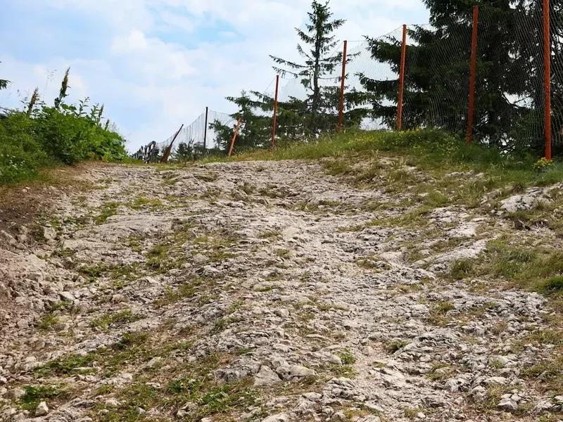
Terrain: The ridge is rugged and exposed. Expect steep ascents and descents, scree slopes, boulder fields, and sections requiring scrambling. Proper footwear and trekking poles are highly recommended to prevent slips and reduce strain on joints.
Water: While glacial lakes and streams are present, water sources can be scarce on the highest parts of the ridge. Always carry sufficient water and a reliable purification method (filter, tablets, or UV steriliser). Treat all water before drinking.
Remoteness: The Făgăraș Mountains are remote, and rescue can be slow. Ensure you have adequate supplies, know your route, and inform someone of your itinerary and expected return time. Consider carrying a personal locator beacon (PLB) or satellite messenger.
Wildlife: While large predators like bears are present in the wider Carpathian region, encounters on the high ridge are rare. However, be aware of your surroundings. Chamois and marmots are more commonly seen.
Emergency Contacts:
- General Emergency Number (Romania): 112
- Mountain Rescue (Salvamont): Specific regional numbers are available; it's wise to have the relevant number for the Făgăraș area saved.
Pre-Trip Checks:
- Verify the opening status of the Transfăgărășan Highway (DN7C).
- Check the mountain weather forecast from reliable sources (e.g., ANM - National Meteorological Administration of Romania, or international mountain weather services).
- Inform a trusted contact of your detailed itinerary, expected return date, and emergency procedures.
Side Trips and Points of Interest
Moldoveanu Peak (2,544 m): The highest point in Romania, summiting Moldoveanu Peak is a significant achievement. The ascent is typically made from the saddle between Vârful Viștea Mare and Moldoveanu, involving a steep climb over scree and rock. The panoramic views from the summit are spectacular, encompassing the entire Făgăraș range and beyond.
Glacial Lakes (Ochiuri): The Făgăraș Mountains are dotted with numerous beautiful glacial lakes, often referred to as "ochiuri" (eyes). Notable examples include Lacul Caprei (Goat's Lake), Lacul Bâlea, and others found in cirques. These offer stunning photographic opportunities and potential water sources (always treat the water).
Vârful Capra (2,417 m) and Vârful Bâlea (2,307 m): These peaks are often part of the initial ascent from Balea Lac and offer excellent vantage points to survey the ridge ahead. They are accessible early in the traverse and provide a good introduction to the alpine environment.
Vârful Viștea Mare (2,527 m): The second-highest peak in Romania, it is often visited in conjunction with Moldoveanu Peak. The saddle between Viștea Mare and Moldoveanu is the key junction for the summit push.
Traditional Shepherd Huts (Stâne): While many are in disrepair, you might encounter remnants of old shepherd huts or even active ones in the lower alpine meadows. These offer a glimpse into the traditional pastoral life of the region.
The Transfăgărășan Highway itself: Even if you are not driving it, understanding its presence and the engineering feat it represents adds context to the accessibility of this wild region. The views from the highway looking up at the ridge you are traversing are impressive.
Leave No Trace

The Făgăraș Mountains are a pristine alpine environment, and adhering to Leave No Trace (LNT) principles is crucial for preserving their natural beauty and ecological integrity. As you traverse this wild landscape, remember that you are a visitor, and your impact should be minimal.
Plan Ahead and Prepare: Research your route thoroughly, understand the terrain, weather, and potential hazards. Pack appropriate gear to be self-sufficient and avoid the need for rescue. Inform someone of your plans.
Travel and Camp on Durable Surfaces: Stick to established trails where they exist. If wild camping, choose established spots or durable surfaces like rock or dry grass. Avoid camping on fragile alpine vegetation, which can take years to recover.
Dispose of Waste Properly: Pack out everything you pack in, including all food scraps, wrappers, and toilet paper. Use designated toilets where available, or dig catholes at least 60 metres away from water sources, trails, and campsites. Bury human waste and pack out toilet paper.
Leave What You Find: Do not disturb plants, rocks, or historical artefacts. Take only photographs and memories.
Minimize Campfire Impacts: Campfires are generally discouraged or prohibited in alpine environments due to the risk of wildfires and damage to vegetation. Use a lightweight camping stove for cooking.
Respect Wildlife: Observe wildlife from a distance. Never feed animals, as it can alter their natural behaviour and diet, and can be harmful to them. Store your food securely to prevent attracting animals.
Be Considerate of Other Visitors: While the Făgăraș Ridge Traverse offers solitude, you may encounter other hikers or shepherds. Keep noise levels down, yield to others on narrow trails, and maintain a respectful distance.
By following these principles, you help ensure that the Făgăraș Mountains remain a wild and beautiful place for future generations to explore.