Transcaucasian Trail - A Grand Vision Across the Caucasus
The Transcaucasian Trail (TCT) is one of the most ambitious long-distance hiking projects of the 21st century. Spanning approximately 1,500 kilometres when fully realised, this world-class thru-hike traverses the Greater and Lesser Caucasus Mountains, connecting the Black Sea to the Caspian Sea. Currently, the trail is a work in progress, with significant, world-class sections fully mapped and blazed across Georgia and Armenia. It offers an unparalleled journey through a landscape where ancient history, diverse cultures, and rugged wilderness converge. From the glaciated peaks of Svaneti in Georgia to the volcanic plateaus and medieval monasteries of Armenia, the TCT is more than just a walk; it is a deep immersion into the "cradle of civilisation."
- Distance: Approximately 1,500 km (total planned length)
- Elevation Gain: Approximately 75,000 m
- Duration: 4–6 months for a full thru-hike; 1–2 weeks for regional sections
- Difficulty: Very Challenging (remote terrain, significant elevation, limited infrastructure)
- Best Time: June to September (high passes are snow-free)
- Key Regions: Svaneti, Racha, Dilijan National Park, Geghama Mountains, Vayots Dzor
- Accommodation: A mix of wild camping, village guesthouses, and mountain shelters
Overview
The Transcaucasian Trail is designed to showcase the immense geographical and cultural diversity of the Caucasus region. This is a land of extremes, where 5,000-metre peaks draped in permanent glaciers overlook semi-arid steppes and lush, temperate rainforests. The trail is divided into two primary corridors: the Greater Caucasus, which runs along the northern border of Georgia, and the Lesser Caucasus, which winds through southern Georgia and across the length of Armenia. For the modern explorer, the TCT represents the last great frontier of European and Western Asian hiking, offering a level of solitude and raw adventure that is increasingly rare on the established trails of the Alps or the Pyrenees.
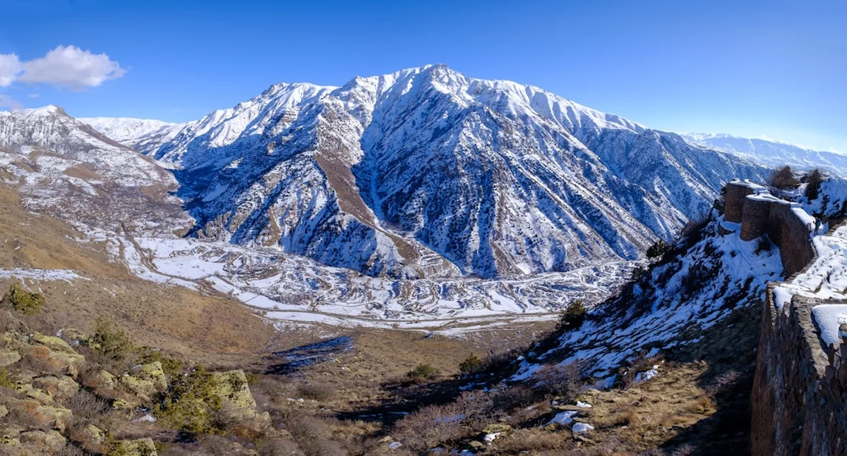
In Georgia, the trail takes hikers through the high-altitude wonders of Svaneti and Racha. Here, the landscape is dominated by the jagged, ice-capped spires of the Greater Caucasus. Hikers walk beneath the shadows of giants like Mount Shkhara and Mount Ushba, passing through ancient villages where medieval stone defensive towers—UNESCO World Heritage sites—still stand guard over the valleys. The Georgian sections are characterised by steep climbs, alpine meadows bursting with wildflowers, and the legendary hospitality of the mountain people, who have lived in these isolated valleys for millennia.
In Armenia, the TCT offers a starkly different but equally mesmerising experience. The route traverses the Lesser Caucasus, a region defined by extinct volcanoes, high-altitude plateaus, and deep, forested canyons. Armenia’s section is a journey through time, connecting remote mountain villages with 10th-century monasteries perched on the edges of cliffs. The Geghama Mountains provide a surreal, lunar-like landscape of red volcanic cones and alpine lakes, while Dilijan National Park, often called "Armenian Switzerland," offers dense forests of beech and oak. The physical challenge in Armenia is significant, with long stretches of dry terrain and substantial vertical gain, but the reward is a profound connection to a land that has served as a crossroads for empires for thousands of years.
The TCT is not merely a physical challenge; it is a conservation and economic development project. By creating a world-class hiking route, the Transcaucasian Trail Association aims to promote sustainable tourism, protect fragile ecosystems, and provide economic opportunities for remote mountain communities that have seen significant emigration in recent decades. To walk the TCT is to participate in the rebirth of these regions, supporting local guesthouses and ensuring that the cultural heritage of the Caucasus remains vibrant and accessible.
History and Cultural Context
The Caucasus Mountains have historically served as both a formidable barrier and a vital bridge between Europe and Asia. For millennia, the Silk Road and its various branches wound through these valleys, carrying silk, spices, and ideas between East and West. The region is a mosaic of languages, religions, and ethnicities, with over 40 distinct languages spoken across the range. This cultural complexity is reflected in the trail itself, which passes through lands inhabited by Georgians, Armenians, Svans, Azeris, and various North Caucasian groups, each with their own unique traditions and histories.
The concept of a unified Transcaucasian Trail was born in 2015, spearheaded by a group of international and local hikers, cartographers, and conservationists. Unlike the well-trodden paths of Western Europe, many of the traditional routes in the Caucasus had fallen into disuse during the Soviet era or were severed by modern political borders. The TCT project involves painstakingly scouting ancient shepherd paths, mapping them using modern GPS technology, and working with local governments to establish protected corridors. It is a grassroots effort that relies heavily on volunteers and local trail-building crews who clear overgrowth and install the red-and-white blazes that guide hikers through the wilderness.
The cultural heritage encountered along the trail is staggering. In Armenia, the trail passes the Noravank and Tatev monasteries, masterpieces of medieval architecture that served as centres of learning and spirituality. In Georgia, the Svan towers of Ushguli represent some of the highest continuously inhabited settlements in Europe, preserved by their extreme isolation. The history of the Caucasus is also one of resilience; the people here have survived countless invasions and political upheavals, yet their tradition of "the guest is a gift from God" remains the cornerstone of their social fabric. Hikers are frequently invited into homes for coffee, homemade cheese, and the potent local grape brandy known as chacha, making the human element of the TCT as memorable as the mountains themselves.
Want more background? Read extended notes on history and cultural context → Learn more
Seasonal Highlights and Weather Reality
The hiking season in the Caucasus is relatively short due to the extreme altitudes and heavy winter snowfall. For most of the trail, the window of opportunity runs from June to late September. Outside of these months, high passes (many of which exceed 2,500 metres) are blocked by snow, and the risk of avalanches is significant. Even within the peak season, weather in the Caucasus is notoriously unpredictable and can change from blistering sunshine to violent thunderstorms within minutes.
Spring (May to June): In the lower elevations of Armenia and southern Georgia, spring is a spectacular time to visit. The valleys are lush and green, and the wildflowers are in full bloom. However, the high passes in the Greater Caucasus remain under deep snow until late June or even early July. Hikers in early June should be prepared for difficult snow crossings and high river levels due to snowmelt.
Summer (July to August): This is the prime window for the high-altitude sections of Svaneti, Racha, and the Geghama Mountains. The weather is generally stable, though afternoon heat in the Armenian valleys can be intense, often exceeding 30°C. In the mountains, daytime temperatures are pleasant (15–25°C), but nights can drop toward freezing. This is also the season of the "Caucasus Monsoon"—brief but powerful afternoon thunderstorms that require hikers to be off high ridges by midday.
Autumn (September to October): September is arguably the best month for the TCT. The summer heat has dissipated, the mosquitoes have vanished, and the autumn colours in the forests of Dilijan and Racha are breathtaking. The weather is often crisp and clear, providing the best visibility for the high peaks. By mid-October, the first winter snows usually begin to fall on the passes, effectively closing the thru-hiking season.
Winter (November to April): The TCT becomes a serious mountaineering and ski-touring proposition. Most of the trail is inaccessible to standard hiking. Temperatures in the mountains can plummet to -20°C or lower, and many remote villages become completely cut off from the outside world by snow.
Recommended Itinerary
The Svaneti Traverse (Georgia Highlight - 10 Days)
This section is widely considered the "crown jewel" of the Georgian TCT, taking hikers from the regional capital of Mestia to the high-altitude village of Ushguli and beyond into the remote wilderness of Racha.
Day 1: Mestia to Zhabeshi
- Distance: 16 km
- Elevation gain: 760 m
- Time: 5–6 hours
- Ascend from Mestia through alpine meadows with views of Mount Ushba
- Pass through the traditional villages of Mulakhi
- Stay in a local guesthouse in Zhabeshi
Day 2: Zhabeshi to Adishi
- Distance: 11 km
- Elevation gain: 900 m
- Time: 5–7 hours
- Steep climb toward the Tetnuldi ski resort area
- Spectacular views of the Adishi Glacier
- Descend into the isolated, ancient village of Adishi (no road access until recently)
Day 3: Adishi to Iprali
- Distance: 19 km
- Elevation gain: 860 m
- Time: 7–9 hours
- Requires a river crossing (often by horse) early in the morning
- Climb to the Chkhunderi Pass (2,655 m) for panoramic glacier views
- Long descent into the Khalde Valley
Day 4: Iprali to Ushguli
- Distance: 13 km
- Elevation gain: 650 m
- Time: 4–5 hours
- Follow the Enguri River toward the highest inhabited village in Europe
- Arrive in Ushguli, a UNESCO World Heritage site dominated by Svan towers and Mount Shkhara
Day 5: Ushguli to Zeskho (The Crossing to Racha)
- Distance: 22 km
- Elevation gain: 1,300 m
- Time: 10–12 hours
- The most challenging day: crossing the Latpari Pass (2,830 m)
- Remote wilderness with no villages; wild camping or Zeskho mountaineering camp
The Armenian Highlands (Armenia Highlight - 7 Days)
This section showcases the volcanic beauty and monastic history of the Lesser Caucasus in Armenia.
Day 1: Dilijan to Parz Lake
- Distance: 14 km
- Elevation gain: 600 m
- Time: 4–5 hours
- Walk through the "Armenian Switzerland" beech forests
- Visit the 13th-century Haghartsin Monastery
- Camp or stay near the scenic Parz Lake
Day 2: Parz Lake to Gosh
- Distance: 9 km
- Elevation gain: 350 m
- Time: 3 hours
- Short, beautiful forest walk to Goshavank Monastery
- Explore the intricate khachkars (stone crosses) of Gosh
Day 3: Gosh to Lake Sevan (Lchashen)
- Distance: 24 km
- Elevation gain: 1,100 m
- Time: 8–9 hours
- Climb out of the forest onto the high-altitude ridges overlooking Lake Sevan
- Arrive at the shores of one of the world's largest high-altitude freshwater lakes
Day 4-7: The Geghama Mountains Traverse
- Distance: 65 km (total over 4 days)
- Elevation: High plateau averaging 2,800 m
- Traverse a landscape of extinct volcanic cones and obsidian fields
- Summit Mount Azhdahak (3,597 m), an extinct volcano with a crater lake
- Encounter Yazidi nomadic shepherds and ancient "vishap" (dragon) stones
- Finish at the Temple of Garni, a 1st-century Hellenistic structure
Important Notes:
- The TCT is a work in progress; some sections require high-level navigation skills and GPS
- Water can be scarce in the Armenian highlands; plan carries carefully
- Resupply points are often 3–5 days apart in remote sections
- Village guesthouses are common in Svaneti but rare in the Geghama Mountains
Planning and Bookings
Book Your Trip
Everything you need to plan your journey
Accommodation
Find places to stay near Tbilisi
Flights
Search flights to Tbilisi
Essential Preparation
Planning a trip on the Transcaucasian Trail requires a higher degree of self-reliance than most European trails. Fitness is paramount; the terrain is rugged, and daily elevation gains of 1,000 metres are common. You must be comfortable with off-trail navigation, as markers can be obscured by vegetation or snow. Tbilisi (Georgia) and Yerevan (Armenia) are the primary hubs for gear, supplies, and logistics. Most hikers fly into one of these cities and use local minibuses (marshrutkas) to reach trailheads.
Language is a significant factor. While younger people in cities speak English, Russian is the lingua franca in rural areas. Learning basic phrases in Georgian or Armenian, or at least the Cyrillic alphabet for reading signs, is highly recommended. Additionally, download offline maps (Maps.me or Gaia GPS) and the official TCT GPX tracks, as mobile signal is non-existent in the deep valleys and high plateaus.
Trail Accommodation
Accommodation on the TCT varies wildly depending on the region. In popular areas like Svaneti, a network of village guesthouses provides a bed, hot shower, and massive home-cooked meals (usually around 50–70 GEL per night including food). In more remote areas like Racha or the Geghama Mountains, you must be fully self-sufficient with a tent.
Accommodation Types:
- Village Guesthouses: Common in Svaneti and Dilijan. Expect warm hospitality, shared bathrooms, and incredible local food. No pre-booking is usually required except in peak August.
- Wild Camping: Permitted almost everywhere in Georgia and Armenia. This is the primary mode of accommodation for thru-hikers. Always camp at least 50 metres from water sources.
- Mountain Shelters: Very rare. A few basic huts exist in the Greater Caucasus (e.g., Zeskho), but they are often in disrepair or require local keys.
- Yazidi/Shepherd Camps: In the Armenian highlands, you may be invited to stay in a shepherd's tent. This is a cultural experience but should not be relied upon as a planned accommodation.
What is NOT provided:
- Organised campsites with facilities (outside of a few private spots)
- Consistent electricity for charging (bring a large power bank)
- Bedding or gear in remote sections
- Reliable rubbish disposal (you must pack everything out to the nearest major town)
Required Gear
- Footwear: Sturdy, waterproof trekking boots with excellent ankle support. The terrain is rocky, muddy, and often involves scree.
- Navigation: GPS device or smartphone with offline maps and spare battery. A physical compass and paper maps (where available) are essential backups.
- Shelter: A high-quality, 3-season tent capable of withstanding high winds and heavy rain.
- Sleeping System: A sleeping bag rated to at least -5°C comfort. Even in summer, alpine temperatures can drop significantly.
- Pack: A 50–70L backpack with a comfortable harness and a waterproof rain cover.
- Clothing: A robust layering system. Include a waterproof/breathable shell (Gore-Tex), a down or synthetic insulated jacket, and moisture-wicking base layers (merino wool is ideal).
- Safety: A Personal Locator Beacon (PLB) or satellite messenger (Garmin inReach) is strongly recommended due to the lack of mobile coverage and remote nature of the trail.
What to Bring
- Food: Lightweight, calorie-dense meals for 4–6 days. While you can buy bread, cheese, and tomatoes in villages, specialised trekking food (dehydrated meals) is unavailable outside Tbilisi or Yerevan.
- Water Treatment: A reliable filter (Sawyer Squeeze or Katadyn BeFree) or purification tablets. Livestock is present in many areas, making untreated water risky.
- Cooking Gear: A multi-fuel or canister stove. Screw-on gas canisters (Primus style) are available in Tbilisi and Yerevan but can be hard to find in smaller towns.
- Sun Protection: High-factor sunscreen (SPF 50+), polarised sunglasses, and a wide-brimmed hat. The alpine sun at 3,000 metres is exceptionally strong.
- First Aid: A comprehensive kit including blister care, rehydration salts, broad-spectrum antibiotics (consult your doctor), and any personal medications.
- Dog Deterrent: An ultrasonic dog repeller or trekking poles. Caucasian Shepherd dogs are large and protective; knowing how to manage encounters is vital.
- Cash: Sufficient local currency (GEL for Georgia, AMD for Armenia). Credit cards are useless in the mountains.
Permits
For the majority of the Transcaucasian Trail, no formal trekking permits are required. However, because the trail often runs close to international borders (Russia, Azerbaijan, Turkey), there are specific regulations hikers must follow to avoid legal trouble or detention.
Border Zone Permits:
- Georgia: If you plan to hike very close to the Russian border (e.g., certain valleys in Upper Svaneti or Tusheti), you may need a border permit. These are issued for free by the Georgian Border Police, but the process can take time. Always carry your passport.
- Armenia: The trail generally stays away from the sensitive border with Azerbaijan, but in regions like Vayots Dzor and Syunik, you may encounter military checkpoints. Always stay on the trail and follow the instructions of soldiers.
National Park Fees:
- Dilijan National Park (Armenia): A small entrance fee is sometimes collected at trailheads or through the visitor centre. It is usually nominal (around 1,000–2,000 AMD).
- Arevik National Park (Armenia): Access to certain core zones may require prior notification to the park office in Meghri.
- Lagodekhi Protected Areas (Georgia): While not on the main TCT spine yet, this nearby area requires registration at the visitor centre before entry.
Visas:
- Georgia: Most Western nationalities (EU, USA, UK, Australia, etc.) can enter Georgia visa-free for up to one year.
- Armenia: Most Western nationalities can enter Armenia visa-free for up to 180 days. Always check the latest regulations before travelling, as these can change.
Important Note: It is currently impossible to cross the border between Armenia and Azerbaijan. The border between Armenia and Turkey is also closed. If your thru-hike involves moving between Georgia and Armenia, you must use official border crossings (such as Sadakhlo/Bagratashen) and then take transport back to the trail. You cannot "hike" across the border in the mountains.
Other Activities in the Area
The Caucasus offers a wealth of experiences beyond the trail. Consider these additions to your itinerary:
- Wine Tasting in Kakheti: Georgia is the birthplace of wine, with a history dating back 8,000 years. Visit the Kakheti region to try wines fermented in traditional clay jars called qvevri.
- Explore Tbilisi's Old Town: A vibrant mix of Persian, Russian, and Art Nouveau architecture. Don't miss the sulphur baths in Abanotubani.
- Yerevan's Café Culture: Armenia's capital is a city of pink tuff stone, outdoor cafés, and a world-class jazz scene. Visit the Cascade Complex for views of Mount Ararat.
- Caving in Imereti: Near Kutaisi, explore the Prometheus Cave or the Sataplia Nature Reserve, home to preserved dinosaur footprints.
- Monastery Hopping: Beyond those on the trail, sites like Vardzia (a massive cave monastery in Georgia) or Geghard (carved into a mountain in Armenia) are essential visits.
- Paragliding in Gudauri: For a different perspective on the Greater Caucasus, take a tandem flight over the Aragvi Valley.
Safety and Conditions
Shepherd Dogs: The single greatest safety concern on the TCT is not bears or wolves, but the Caucasian Shepherd dogs (Gampr in Armenia). These dogs are bred to protect livestock from predators and can be extremely aggressive toward hikers. Strategy: Never run. Stand your ground, keep your trekking poles between you and the dog, and wait for the shepherd to intervene. If no shepherd is present, back away slowly while facing the dog. Avoid walking through the middle of a sheep or cattle herd.
Remote Terrain and Rescue: Search and rescue (SAR) services in the Caucasus are not as developed as in the Alps. In many areas, a rescue would be performed by local volunteers or the military and could take days. A satellite communication device is essential. Ensure your travel insurance specifically covers "search and rescue" and "high-altitude trekking" up to 4,000 metres.
Weather and Exposure: Hypothermia is a real risk, even in summer. Storms can bring rapid temperature drops and sleet. Conversely, heatstroke is a danger in the lower Armenian valleys. Always carry at least 3 litres of water capacity and high-quality rain gear.
River Crossings: In the Greater Caucasus, glacial melt makes rivers significantly higher and faster in the afternoon. Always attempt major crossings early in the morning. If a river looks too deep or fast, do not risk it—wait for a horse or find an alternative route.
Political Sensitivity: Avoid wandering into unmarked border zones. Keep your passport on you at all times. Be aware of the local political situation, particularly regarding the occupied territories of Abkhazia and South Ossetia in Georgia; entering these regions from Russia is a criminal offence under Georgian law and will prevent you from entering Georgia in the future.
Side Trips and Points of Interest
Mount Azhdahak (Armenia): The highest point of the Geghama Range (3,597 m). The climb is non-technical but strenuous. The summit offers a perfect crater lake and views that stretch from Lake Sevan to Mount Ararat. It is a highlight of the Armenian section and well worth the extra day.
The Chalaadi Glacier (Georgia): A popular side trip from Mestia. A relatively easy walk leads to the foot of the glacier, where you can witness the raw power of the ice and the birth of the river. It provides a close-up look at the high-alpine environment without a massive climb.
Tatev Monastery and the Wings of Tatev (Armenia): While the TCT passes near Tatev, taking the time to ride the world's longest reversible aerial tramway across the Vorotan Canyon is a must. The monastery itself is a 9th-century fortress of spirituality and learning.
Ushguli's Lamaria Church: Located at the far end of the Ushguli village complex, this 12th-century church sits against the backdrop of the Shkhara Glacier. It is one of the most atmospheric and photographed spots in the entire Caucasus.
The Garni Gorge "Symphony of Stones": Near the end of the Geghama traverse, descend into the Azat River gorge to see the incredible basalt column formations that resemble a giant pipe organ. It is a geological wonder of the Lesser Caucasus.
Leave No Trace
The Transcaucasian Trail passes through some of the last remaining pristine wilderness in Eurasia. As visitor numbers grow, it is vital that hikers adhere to strict Leave No Trace principles to preserve these landscapes and respect local communities.
Key Principles for the Caucasus:
- Waste Management: There is no rubbish collection in the mountains. You must pack out every single item, including fruit peels and cigarette butts. In villages, only dispose of rubbish in large communal bins in major towns.
- Human Waste: Use a trowel to bury waste at least 15–20 cm deep and at least 60 metres from any water source. Pack out your toilet paper in a sealed bag.
- Fire Safety: Wildfires are a major risk in the dry Armenian summer. Use a stove for cooking rather than building campfires. If you must have a fire, use existing fire rings and ensure it is completely extinguished with water.
- Respecting Livestock: Do not disturb sheep or cattle. Close all gates behind you. Remember that the mountains are a working landscape for local shepherds.
- Cultural Sensitivity: Ask permission before taking photos of people, especially in remote villages. Dress modestly when entering churches or monasteries (shoulders and knees covered; women may need a headscarf).
- Water Protection: Do not use soap (even biodegradable) directly in streams or lakes. Carry water 60 metres away for washing.