Trans-Catalina Trail - California’s Island Odyssey
The Trans-Catalina Trail (TCT) is a premier coastal trekking experience that traverses the rugged, sun-drenched spine of Santa Catalina Island, located 35 kilometres off the coast of Southern California. Spanning 62.4 kilometres from the historic Mediterranean-style harbour of Avalon in the east to the remote, wind-swept cliffs of Starlight Beach in the west, this trail offers a landscape unlike any other in the United States. Walkers journey through a unique Mediterranean ecosystem, ascending steep ridgelines that provide 360-degree views of the Pacific Ocean, descending into secluded coves with crystal-clear turquoise waters, and crossing rolling grasslands where American bison—descendants of a 1924 film crew’s forgotten herd—roam freely. This is a journey of physical endurance and ecological discovery, where the scent of coastal sage scrub mingles with the salt air, and the absence of motorised traffic creates a profound sense of isolation just a short ferry ride from the sprawling metropolis of Los Angeles. The Trans-Catalina Trail is not merely a walk across an island; it is an immersion into a preserved wilderness that challenges the legs and restores the spirit.
- Distance: 62.4 km point-to-point
- Duration: 3–5 days
- Season: Year-round (Spring and Autumn recommended; Summer is extremely hot)
- Campsites (mandatory booking): Black Jack, Little Harbor, Two Harbors, Parsons Landing
- Total Elevation Gain: 4,937 m
- Difficulty: Challenging (steep gradients and high exposure)
- Direction: Generally walked East to West (Avalon to Two Harbors/Starlight Beach)
Overview
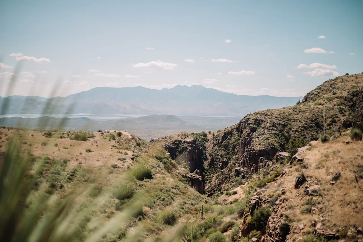
The Trans-Catalina Trail is frequently described as a "rollercoaster" by those who have traversed its length. Unlike many mainland trails that follow gentle switchbacks, the TCT often takes a direct line up and down the island’s ridgelines, resulting in significant cumulative elevation gain that belies the island's modest peak heights. The route is a masterclass in coastal topography, beginning at sea level in Avalon, climbing to the island’s interior highlands, and dropping back to the ocean multiple times before reaching the western terminus. The terrain is predominantly exposed, with very little natural shade, making the Mediterranean climate a primary factor in the trek's difficulty. Walkers must be prepared for intense sun, steep gravelly descents that test knee stability, and the logistical challenge of carrying or caching water in a semi-arid environment.
The ecological diversity of the trail is one of its most compelling features. As part of the Channel Islands archipelago, Catalina is home to over 60 endemic species of plants and animals found nowhere else on Earth, including the Catalina Island Fox and the Catalina Ironwood tree. The trail passes through various distinct zones: the lush canyons of the windward side, the high chaparral of the interior, and the stark, beautiful desert-like landscapes of the West End. The presence of the bison adds a surreal, almost prehistoric element to the hike, reminding walkers that they are in a managed but wild sanctuary. The trail is managed by the Catalina Island Conservancy, a non-profit organisation dedicated to preserving 88% of the island in its natural state, ensuring that the TCT remains a pristine corridor for adventure.
Logistically, the trail requires meticulous planning. Because wild camping is strictly prohibited, hikers must secure reservations at specific campgrounds spaced along the route. These sites—ranging from the high-altitude pines of Black Jack to the palm-fringed beach of Little Harbor—provide essential infrastructure but require advance booking, often months in advance. The journey concludes at Two Harbors or the remote Parsons Landing, where the sense of accomplishment is matched only by the vastness of the Pacific horizon. For those seeking a multi-day challenge that combines mountain-style climbing with coastal beauty, the Trans-Catalina Trail stands as one of the most rewarding treks in North America.
History and Cultural Context
The human history of Santa Catalina Island stretches back over 8,000 years, beginning with the Tongva people, who called the island "Pimu" or "Pimugna." The Pimuans were expert maritime traders and artisans, known for their high-quality soapstone (steatite) carvings, which they traded with mainland tribes for acorns and other resources. As you walk the TCT, you are traversing ancestral lands that once supported a thriving indigenous population well-integrated into the coastal economy of Southern California. Evidence of their presence remains in the form of shell middens and ancient quarry sites, though many are protected and off-limits to the public to ensure their preservation.
European contact began in 1542 when Spanish explorer Juan Rodríguez Cabrillo claimed the island for Spain. Over the following centuries, the island saw a succession of uses, from a base for sea otter hunters and smugglers to a site for Union Army barracks during the American Civil War. However, the modern character of the island was largely shaped by the Wrigley family, famous for their chewing gum empire. William Wrigley Jr. purchased the majority of the island in 1919 with the vision of creating a world-class resort and a permanent home for the Chicago Cubs baseball team’s spring training. His investment led to the construction of the iconic Catalina Casino and the development of Avalon as a premier tourist destination.
The conservation history of the island is perhaps the most significant for modern hikers. In 1972, Philip K. Wrigley and Alice Loffler Wrigley established the Catalina Island Conservancy, transferring 42,000 acres of the island to the non-profit to ensure it would never be developed. This act of philanthropy preserved the rugged interior that the Trans-Catalina Trail now explores. The trail itself was officially dedicated in 2009, linking existing fire roads and newly cut single-track paths to create a continuous traverse. Today, the TCT serves as a living museum of the island’s transition from an indigenous stronghold to a private fiefdom and, finally, to a protected wilderness area accessible to all who are willing to put in the effort to walk it.
Want more background? Read extended notes on history and cultural context → Learn more
Seasonal Highlights and Weather Reality
The Trans-Catalina Trail is accessible year-round, but the experience varies dramatically depending on the month. Unlike alpine trails, the primary weather hazard here is not snow, but heat and lack of water. The Mediterranean climate means mild, wet winters and hot, dry summers. Understanding these cycles is crucial for a safe and enjoyable trek.
Spring (March to May): This is widely considered the "Golden Era" for the TCT. Following the winter rains, the island’s hillsides turn a vibrant, emerald green, and wildflowers—including the endemic Catalina Mariposa Lily—carpet the landscape. Temperatures are typically mild, ranging from 15°C to 22°C, making the steep climbs much more manageable. This is also the best time for birdwatching and spotting the island fox. However, this is the most popular season, and campsites book out the moment they become available.
Autumn (September to November): As the summer heat begins to fade, Autumn offers a second window of ideal hiking weather. The ocean remains warm enough for swimming at Little Harbor and Two Harbors, and the "June Gloom" (coastal fog) has usually dissipated, providing the clearest views of the mainland and surrounding islands. The landscape is golden and dry during this period, offering a classic California chaparral aesthetic.
Winter (December to February): Winter brings the possibility of rain, which can turn the island’s clay-heavy soils into "boot-sucking" mud, making the steep descents treacherous. However, for experienced hikers, winter offers the greatest solitude and crisp, cool air. Daytime temperatures are often perfect for hiking, though nights can drop to 5°C in the interior highlands like Black Jack. Storms can occasionally cancel ferry services, so flexibility is required.
Summer (June to August): Hiking the TCT in mid-summer is a serious undertaking and is generally discouraged for those not highly experienced with desert-like conditions. Temperatures in the interior can regularly exceed 30°C, and with virtually no shade on the ridgelines, the risk of heat exhaustion and dehydration is high. If you must hike in summer, start at dawn, rest during the midday heat, and carry significantly more water than you think you need.
Recommended Itinerary

5-Day Trans-Catalina Trail Itinerary
Day 1: Avalon to Black Jack Campground
- Distance: 17.2 km
- Elevation gain: 820 m
- Time: 6–8 hours
- Start at the Hermit Gulch Trailhead near the Avalon Botanical Gardens
- Steady climb up to the ridgeline with spectacular views back over Avalon Harbour
- Pass the "Rent-a-Plate" junction and follow the ridge toward the island's interior
- Traverse through coastal sage scrub and past the Haypress Reservoir
- Arrive at Black Jack Campground, nestled among pine and eucalyptus trees at 480 m elevation
- This is a demanding first day with significant climbing; ensure you have plenty of water from the start
Day 2: Black Jack to Little Harbor
- Distance: 13.2 km
- Elevation gain: 450 m (with a significant descent)
- Time: 5–6 hours
- Descend from Black Jack toward the "Airport in the Sky" (3 km from camp)
- Stop at the Airport DC-3 Grill for a famous "Buffalo Burger" and to refill water
- Continue the descent toward the windward side of the island
- The trail drops steeply toward the coast, offering the first views of the rugged western shoreline
- Arrive at Little Harbor, often voted one of the best campgrounds in the US, featuring palm trees and two sandy coves
- Excellent opportunity for an afternoon swim in the Pacific
Day 3: Little Harbor to Two Harbors
- Distance: 8.5 km
- Elevation gain: 480 m
- Time: 4–5 hours
- A shorter distance but involves a very steep climb out of Little Harbor onto the ridgeline
- Follow the "Whale Tail" ridge, which offers some of the most iconic 360-degree views of the entire trail
- Descend steeply into the village of Two Harbors, the island's "second city"
- Two Harbors offers a general store, a restaurant, and real showers
- Stay at the Two Harbors Campground, located on a bluff overlooking the ocean, about 1 km from the village centre
Day 4: Two Harbors to Parsons Landing
- Distance: 10.6 km
- Elevation gain: 550 m
- Time: 5–6 hours
- This is the most rugged section of the trail, crossing the "West End"
- The climb out of Two Harbors is exceptionally steep and exposed
- Traverse the high ridges of the Silver Peak Trail, reaching the highest point on the TCT
- Descend a notoriously steep, gravelly path toward the remote beach at Parsons Landing
- Parsons Landing is a primitive beach camp with no running water (water and wood must be pre-purchased and collected from lockers)
- Enjoy the ultimate sense of isolation on this secluded stretch of coast
Day 5: Parsons Landing to Two Harbors (via West End Road)
- Distance: 12.9 km
- Elevation gain: 150 m (mostly flat)
- Time: 4–5 hours
- Instead of retracing the mountainous Silver Peak Trail, follow the coastal West End Road
- This flat, easy-going dirt road hugs the coastline, passing several scout camps and hidden coves
- Excellent opportunities for spotting marine life and enjoying the sea breeze
- Return to Two Harbors to catch the ferry back to the mainland
- Optional: If you have the energy, include the 7.4 km return trip to Starlight Beach from Parsons Landing before heading back
Important Notes:
- Campsites must be booked in sequence; do not attempt to "stealth camp" as it is strictly prohibited and enforced
- The "Airport in the Sky" is a critical logistical point for food and water
- The descent into Parsons Landing is very hard on the knees; trekking poles are highly recommended
- Check ferry schedules carefully, as return boats from Two Harbors may be less frequent than from Avalon
Planning and Bookings
Book Your Trip
Everything you need to plan your journey
Accommodation
Find places to stay near Avalon
Flights
Search flights to Avalon
Essential Preparation
The Trans-Catalina Trail requires a high level of logistical coordination. Because the island is a protected conservancy, you cannot simply show up and hike. Your planning should begin at least six months in advance, particularly if you intend to hike during the peak spring season. The first step is securing your campsite reservations, as these dictate your itinerary. Once campsites are confirmed, you must book your ferry transport to and from the island. There are two main ferry operators: Catalina Express (serving Long Beach, San Pedro, and Dana Point) and the Catalina Flyer (serving Newport Beach). Most hikers arrive in Avalon and depart from Two Harbors, which requires a "multi-city" ferry booking.
Physical preparation is equally important. The TCT is not a flat coastal stroll; it involves nearly 5,000 metres of cumulative elevation gain over 62 kilometres. Training should focus on steep ascents and descents while carrying a fully loaded pack. Because the terrain is often hard-packed dirt and loose gravel, ensuring your footwear is well broken-in is essential to prevent blisters. Finally, you must obtain a free hiking permit from the Catalina Island Conservancy website or at the Trailhead visitor centre in Avalon before starting.
Trail Accommodation
Accommodation on the TCT is limited to designated campgrounds managed by Catalina Island Company. Each site offers a different experience, and all must be booked through the ReserveAmerica system.
Campground Facilities:
- Black Jack: Located in the interior at 480 m. Features picnic tables, fire rings, chemical toilets, and a seasonal water spigot.
- Little Harbor: Coastal site. Features picnic tables, fire rings, cold showers, and potable water. This is the only site on the windward side.
- Two Harbors: Bluff-top site near the village. Features picnic tables, fire rings, chemical toilets, and potable water. Pay showers and laundry are available in the village.
- Parsons Landing: Primitive beach camping. Features fire rings and chemical toilets. No running water. You must purchase a "key" for a locker containing 7.5 litres of water and a bundle of firewood when making your reservation.
Booking Requirements:
- Reservations open on a rolling basis, typically 6 months in advance.
- Costs vary by season but generally range from US$20 to US$30 per person, per night.
- A minimum two-night stay may be required during weekends at certain sites.
- Check-in is usually at 2:00 PM, and check-out is at 11:00 AM.
Required Gear
- Trekking Poles: Non-negotiable for most. The descents on the TCT are famously steep and covered in loose scree; poles are essential for saving your knees and preventing falls.
- Sun Protection: A wide-brimmed hat, high-SPF sunscreen, and polarised sunglasses. The exposure on the ridgelines is 100% for hours at a time.
- Sturdy Hiking Boots: Mid-to-high cut boots with good traction are preferred over trail runners due to the rocky, uneven terrain and the weight of a multi-day pack.
- Water Storage: Capacity for at least 3–4 litres of water. On hot days, you will consume water rapidly between refill points.
- Lightweight Tent: A free-standing tent is best, as some campsites have hard-packed ground where stakes are difficult to drive.
- Navigation: A physical map of the island (available at the Conservancy) and a GPS app with offline maps (e.g., AllTrails or Gaia GPS).
- First Aid Kit: Must include blister treatment (moleskin or Leukotape), electrolyte salts, and tweezers (for cactus spines).
What to Bring
- Food: All meals for the duration, minus what you might eat at the Airport in the Sky or Two Harbors. High-calorie, lightweight dehydrated meals are best.
- Water Treatment: While most camps have potable water, a lightweight filter (like a Sawyer Squeeze) is a good backup for emergencies.
- Electrolytes: Salt tablets or powder mixes are crucial to prevent cramping and heat exhaustion in the Mediterranean sun.
- Clothing Layers: Moisture-wicking base layers, a lightweight fleece for cool island nights, and a windbreaker for the exposed ridges.
- Stove and Fuel: Lightweight canister stove (e.g., Jetboil or MSR PocketRocket). Note: You cannot bring isobutane canisters on the ferry; you must purchase them in Avalon or Two Harbors.
- Power Bank: To keep your phone/GPS charged, as there are no electrical outlets at the campgrounds.
- Trash Bags: This is a "Pack It In, Pack It Out" trail. You must carry all your rubbish to the bins at campgrounds or villages.
Permits
All hikers on the Trans-Catalina Trail are required to have a valid hiking permit. Fortunately, unlike the competitive permit systems of the High Sierra, the TCT hiking permit is free and not subject to a quota. However, it is mandatory for safety and search-and-rescue purposes. You can obtain your permit online through the Catalina Island Conservancy website or in person at the Trailhead visitor centre in Avalon.
Permit and Booking Strategy:
- Campsite First: The "real" permit is your campground reservation. Secure these through ReserveAmerica before doing anything else. If you don't have a campsite, you cannot legally hike the trail.
- Locker Keys: If staying at Parsons Landing, you must add the water/wood locker key to your reservation. You will pick up the actual key at the Two Harbors Visitor Services office before heading to the West End.
- Ferry Coordination: Once your sites are booked, immediately book your ferry. If you are hiking Avalon to Two Harbors, book your arrival to Avalon and your departure from Two Harbors.
- Conservancy Membership: Consider joining the Catalina Island Conservancy. Members often get discounts on certain services and the satisfaction of supporting the trail's maintenance.
Costs and Fees:
- Hiking Permit: Free.
- Campground Fees: Approximately US$25–$30 per person, per night.
- Ferry Fees: Approximately US$80–$90 round-trip.
- Parsons Landing Water/Wood: Approximately US$25 per locker.
Other Activities in the Area
Santa Catalina Island offers a wealth of activities for those who want to extend their stay before or after the hike:
- Snorkelling and Diving: The Casino Point Dive Park in Avalon is world-famous for its kelp forests and bright orange Garibaldi fish. The water is remarkably clear and protected.
- Bison Expedition Tours: If you didn't see enough bison on the trail, these 4WD tours take you deep into the interior to find the herds and learn about island ecology.
- Zip Line Eco Tour: Located near Avalon, this series of zip lines drops 180 metres down toward the ocean, providing a high-adrenaline view of the canyons.
- Glass Bottom Boat Tours: A great way to see the marine protected areas without getting wet, perfect for a recovery day in Avalon.
- Kayaking: Rent a kayak in Two Harbors to explore the secluded coves of the West End that are inaccessible by foot.
- The Catalina Museum for Art & History: Located in Avalon, this museum provides deep insights into the island's Tongva roots and its Hollywood golden age.
Safety and Conditions
Heat and Hydration: The single greatest danger on the TCT is heat-related illness. The combination of steep climbs, heavy packs, and zero shade can lead to heat exhaustion or heat stroke very quickly. Hikers must drink at least 4–6 litres of water per day during warm spells and supplement with electrolytes. If you feel dizzy, nauseated, or stop sweating, stop immediately in whatever shade you can find and cool down.
Bison Safety: While they may look like slow, docile cows, the American bison are wild animals that can weigh up to 900 kilograms and run at 55 kilometres per hour. They are unpredictable and can be aggressive if they feel cornered. Always maintain a distance of at least 40 metres. If a bison is on the trail, do not try to walk past it; wait for it to move or give it a very wide berth by heading off-trail (carefully). Never approach a bison for a photo.
Rattlesnakes: The Southern Pacific Rattlesnake is common on the island. They generally avoid humans but will strike if stepped on or provoked. Watch your step, especially in tall grass or when stepping over logs and rocks. If bitten, stay calm, immobilise the limb, and use a satellite communicator to call for help. Do not use "snake bite kits" or try to suck out the venom.
Terrain Hazards: The "Catalina Scree"—loose, marble-like gravel on steep slopes—makes for very slippery descents. Falls are common, and ankle sprains are the most frequent injury on the trail. Use trekking poles and take small, deliberate steps on the downhill sections.
Emergency Communication: Cell service is spotty in the interior and non-existent at Parsons Landing. Carrying a satellite messenger (like a Garmin inReach or Zoleo) is highly recommended for any multi-day trek on the island.
Side Trips and Points of Interest
Starlight Beach: The official western terminus of the TCT. Located 7.4 km (return) from Parsons Landing, this remote beach is rarely visited and offers a sense of "end of the world" solitude. The trail to the beach is rugged but rewarding, featuring some of the best coastal views on the island. It is the perfect place to watch the sunset before your final night at Parsons Landing.
Airport in the Sky: Situated at 488 metres elevation, this historic airport was built by levelling two mountain peaks. It serves as a vital mid-point for hikers. The DC-3 Grill offers hot meals, cold drinks, and a chance to rest in the shade. Don't miss the small nature centre next to the restaurant, which explains the island's unique geology and flora.
The Whale Tail: This is a section of the ridgeline between Little Harbor and Two Harbors. From the top of the climb, the island narrows significantly, and you can see the ocean on both the windward and leeward sides simultaneously. The shape of the land below resembles a whale's tail, providing one of the most photographed vistas in California.
Lone Tree Point: A short detour on the way to Two Harbors that offers a dramatic overlook of the rugged cliffs and the deep blue waters of the Pacific. It’s a quiet spot for reflection away from the main trail traffic.
Leave No Trace
The Catalina Island Conservancy works tirelessly to protect this fragile ecosystem, and hikers must do their part. The island is home to many endangered species that are highly sensitive to human impact. Following Leave No Trace principles is not just a suggestion; it is a requirement for preserving the trail for the future.
Your responsibility as a walker:
- Pack It In, Pack It Out: There are no rubbish bins between campgrounds. Carry all food scraps, wrappers, and hygiene products with you.
- Stay on the Trail: Off-trail hiking causes erosion and destroys the delicate cryptobiotic soil crusts and endemic plants.
- Respect Wildlife: In addition to bison, do not feed the Catalina Island Foxes. They are bold and may approach your camp; keep all food secured in bags or lockers.
- Fire Safety: Fires are only permitted in designated fire rings at campgrounds. During high fire danger periods, all fires (including charcoal) may be banned. Always check the current fire status at the visitor centre.
- Water Conservation: Water is a precious resource on the island. Use only what you need at spigots and never wash dishes directly in the water troughs or at the taps.
- Proper Waste Disposal: Use the provided toilets at campgrounds. If you must go between camps, bury human waste in a "cathole" 15–20 cm deep and at least 60 metres from the trail or any water source.