Tour du Roc d'Enfer - The Devil's Rock Trail
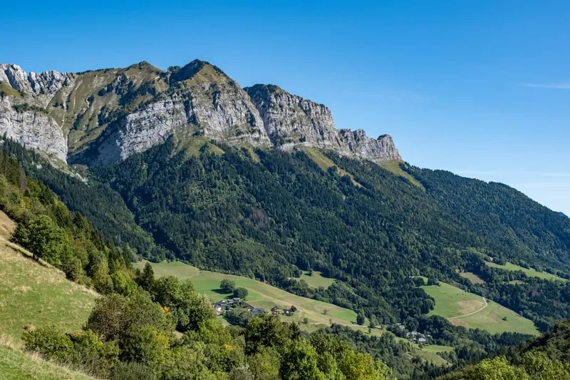
The Tour du Roc d'Enfer is a challenging multi-day trek in the French Alps, offering a spectacular journey through rugged mountain terrain, alpine meadows, and dense forests. This 55 km circuit, with a demanding 3700 metres of elevation gain, is designed for experienced hikers seeking a true alpine adventure. The trail winds its way around the imposing Roc d'Enfer massif, providing breathtaking panoramic views of the surrounding peaks and valleys. It's a route that tests endurance and rewards with unparalleled natural beauty, showcasing the raw power and serene landscapes of the Haute-Savoie region.
- Distance: 55.0 km one-way (circuit)
- Duration: 4-5 days
- Season: June to September
- Difficulty: Challenging
- Highest point: Approximately 2400 m
- Base town: Les Gets / Morzine
- Access: Nearest major airport is Geneva (GVA). Road access to trailheads is good.
Overview
The Tour du Roc d'Enfer is a demanding yet incredibly rewarding circuit that circumnavigates the dramatic Roc d'Enfer, a prominent peak in the Chablais Alps. This trail is not for the faint-hearted; it features significant elevation changes, steep ascents and descents, and sections that require sure-footedness and a good head for heights. The route typically begins and ends in the charming alpine villages of Les Gets or Morzine, providing convenient access and amenities.
The trek is characterised by its diverse landscapes. You'll traverse through dense pine forests, emerge onto vast alpine pastures dotted with wildflowers in summer, and navigate rocky, exposed ridges offering expansive vistas. The higher sections of the trail often involve scrambling and exposed paths, particularly as you approach the Roc d'Enfer itself. The sense of remoteness and the sheer scale of the mountains are palpable throughout the journey.
This trail is best suited for those with a solid level of fitness and prior experience in mountain hiking. The weather in the Alps can be unpredictable, with rapid changes from sunshine to storms, so preparedness is key. The reward for your efforts is an intimate connection with the alpine environment, stunning photographic opportunities, and the satisfaction of completing a significant mountain challenge.
History and Cultural Context
The Roc d'Enfer massif and the surrounding valleys have a long history of human interaction, primarily driven by pastoralism and, in more recent times, tourism. For centuries, these high pastures were used by local communities for summer grazing of livestock, a practice that shaped the landscape and fostered a unique alpine culture. The traditional stone huts and the network of ancient mule tracks bear testament to this heritage.
The name "Roc d'Enfer" (Devil's Rock) likely stems from the formidable and imposing appearance of the massif, its sheer cliffs and rugged terrain perhaps inspiring awe and a sense of danger among early inhabitants. The area has always been a frontier, a place where the wildness of nature is ever-present.
In the late 19th and early 20th centuries, as mountaineering and hiking gained popularity, the Alps became a destination for exploration and recreation. Local guides and enthusiasts began to map out routes, making the more accessible peaks and ridges available to a wider audience. The Tour du Roc d'Enfer, while not a single historical expedition, evolved from these efforts, with sections of the trail being established over time to connect existing paths and provide a comprehensive circuit around the massif.
Today, the region thrives on tourism, with villages like Morzine and Les Gets being popular year-round destinations for skiing in winter and hiking and mountain biking in summer. The Tour du Roc d'Enfer represents a way to experience the natural grandeur of the area away from the more developed resort infrastructure, offering a glimpse into the wilder, more traditional alpine landscape.
Seasonal Highlights and Weather Reality
The best time to undertake the Tour du Roc d'Enfer is during the summer months, from June to September. During this period, the snow has typically melted from the higher passes, and the alpine meadows are in bloom, creating a vibrant and picturesque environment.
June: Early June can still see snow at higher elevations, particularly on north-facing slopes. Some higher sections of the trail might be impassable or require snow gear and navigation skills. Wildflowers begin to appear, and the landscape is fresh and green.
July and August: These are the peak months for hiking. The weather is generally warmer and more stable, though thunderstorms are common in the afternoons. The alpine meadows are at their most spectacular, bursting with a colourful array of wildflowers. This is also the busiest time for hikers, and mountain refuges can be crowded.
September: September offers a beautiful transition into autumn. The crowds thin out, the air is crisp, and the larch trees begin to turn golden, adding a stunning autumnal hue to the landscape. The weather can be more unpredictable, with a higher chance of early snowfalls, especially towards the end of the month.
Weather Considerations: Mountain weather is notoriously fickle. Even in summer, conditions can change rapidly. Expect sunshine, rain, fog, and strong winds, sometimes all within the same day. Temperatures can vary significantly with altitude; it can be warm in the valleys but cold and even freezing at higher elevations, especially at night. Always check the weather forecast before setting out and be prepared for all conditions.
Recommended Itinerary
4-Day Tour du Roc d'Enfer Itinerary
Day 1: Les Gets to Refuge de la Vogealle (or similar)
- Distance: Approximately 12 km
- Elevation gain: Approximately 1000 m
- Time: 5-6 hours
- Start in Les Gets, heading towards the higher pastures.
- The initial ascent is steady through forests, gradually opening up to alpine meadows.
- Pass by traditional mountain farms and chalets.
- Aim for a refuge or designated camping area in the upper valley, such as near the Lac de la Vogealle, to position yourself for the next day's climb.
- Enjoy the first expansive views of the surrounding peaks.
Day 2: Refuge de la Vogealle to Refuge de la Chardonneta (or similar)
- Distance: Approximately 15 km
- Elevation gain: Approximately 1200 m
- Elevation loss: Approximately 800 m
- Time: 6-7 hours
- This is a challenging day, involving a significant climb to a high pass.
- Ascend towards the Col de la Chardonneta or a similar high point, offering dramatic panoramic views.
- The terrain will become more rugged, with rocky sections and potentially some scree.
- Descend towards your next refuge, which might be located in a different valley or on the flank of another mountain.
- Be prepared for exposed sections and potentially windy conditions at the pass.
Day 3: Refuge de la Chardonneta to Refuge de la Pointe de la Grande Mollesse (or similar)
- Distance: Approximately 14 km
- Elevation gain: Approximately 900 m
- Elevation loss: Approximately 700 m
- Time: 5-6 hours
- Continue traversing the mountain range, often at high altitude.
- The route may involve navigating along ridges with spectacular drop-offs.
- This day offers continuous stunning scenery, with opportunities to spot wildlife.
- The goal is to reach a refuge that positions you for the final descent back towards the starting area.
- The terrain can be varied, including rocky paths, alpine meadows, and potentially some steeper descents.
Day 4: Refuge de la Pointe de la Grande Mollesse to Les Gets
- Distance: Approximately 14 km
- Elevation gain: Approximately 600 m
- Elevation loss: Approximately 1200 m
- Time: 4-5 hours
- The final day involves a descent back towards the valley floor and the village of Les Gets.
- The descent can be steep in places, so take care with your footing.
- Enjoy the last views of the Roc d'Enfer massif as you make your way back.
- Arrive back in Les Gets, completing the circuit.
- Celebrate your accomplishment with a well-deserved meal and rest.
Alternative 5-Day Itinerary: For a more relaxed pace, consider breaking down one of the longer days or adding an extra night at a particularly scenic location. This allows for more time to enjoy the views, take photographs, and appreciate the alpine environment.
Important Notes:
- Refuge availability and booking are essential, especially during peak season.
- Trail conditions can vary; always check local advice.
- This itinerary is a suggestion; actual routes and distances may vary based on specific refuge choices and trail conditions.
- Carry sufficient water or a purification method, as water sources can be scarce at higher altitudes.
Planning and Bookings
Book Your Trip
Everything you need to plan your journey
Accommodation
Find places to stay near Morzine
Flights
Search flights to Morzine
Essential Preparation
The Tour du Roc d'Enfer is a serious undertaking that requires thorough preparation. Begin by assessing your fitness level; this trek involves significant daily elevation gains and losses, often over challenging terrain. Aim to build up your stamina with regular hiking, including hill training, in the months leading up to your trip.
Logistics are crucial. Decide on your starting and ending point, typically Les Gets or Morzine. These villages offer a range of accommodation, from hotels and apartments to campsites, and are well-connected by public transport and road. Geneva Airport (GVA) is the most convenient international gateway, with regular bus and train services to the region.
Book your accommodation in mountain refuges well in advance, particularly if you plan to hike during July or August. Refuges often have limited capacity and are popular with both hikers and local mountaineers. Confirm their opening dates and booking procedures. If you plan to camp, research designated wild camping areas or official campsites, adhering to local regulations.
Familiarise yourself with the route. While the trail is generally well-marked, having detailed maps, a GPS device or app, and a compass is essential. Understand the daily distances, elevation profiles, and potential hazards.
Trail Accommodation
Accommodation along the Tour du Roc d'Enfer primarily consists of mountain refuges (refuges de montagne) and, in some areas, designated camping spots. Wild camping may be permitted in certain areas but is often restricted or prohibited, so always check local regulations.
Mountain Refuges:
- Booking Requirements: Advance booking is highly recommended, often mandatory, especially during the summer season (June-September). Contact refuges directly via phone or email. Some may have online booking systems.
- Facilities Provided: Refuges typically offer dormitory-style sleeping arrangements with mattresses and blankets. They usually have a communal dining area where meals (breakfast, lunch, dinner) can be purchased. Basic toilet facilities (often composting or pit toilets) and sometimes showers are available. Some refuges may have limited charging facilities for electronic devices.
- What's NOT Provided: Sleeping bags are usually required (even if blankets are provided, a liner is recommended for hygiene). You will need to bring your own toiletries, towel, and any personal medications. Cooking facilities for self-catering are generally not available to hikers, though some may have a small area for preparing simple snacks.
- Seasonal Availability: Most refuges in this region operate from mid-June to mid-September. Some may open earlier or close later, depending on snow conditions and demand. Always verify their operating dates.
- Costs: Prices vary but expect to pay approximately €40-€70 per person per night for a dormitory bed, often including breakfast. Evening meals are typically an additional €15-€25.
Camping:
- Designated camping areas may be available near some refuges or in specific valley locations.
- Wild camping regulations vary; it is often restricted in national parks and nature reserves. Always seek local information.
- If camping, you will need to carry all your camping gear, including a tent, sleeping bag, and cooking equipment.
Required Gear
- Sturdy Hiking Boots: Waterproof, with good ankle support and a well-worn sole. Essential for navigating rocky and uneven terrain.
- Waterproof and Windproof Jacket: A breathable, high-quality shell jacket (e.g., Gore-Tex) is crucial for protection against sudden weather changes.
- Waterproof Overtrousers: To complement your jacket, ensuring full protection from rain.
- Warm Layers: Including a fleece jacket or insulated mid-layer, and thermal base layers (merino wool or synthetic). Temperatures can drop significantly at altitude.
- Hiking Trousers: Quick-drying and comfortable, preferably convertible to shorts.
- Backpack: A comfortable, well-fitting backpack of 40-60 litres capacity, with a rain cover.
- Navigation Tools: Detailed topographic maps of the area, a compass, and a GPS device or smartphone with offline mapping capabilities.
- Head Torch: With spare batteries, essential for early starts, late finishes, or in refuges.
- First-Aid Kit: Comprehensive kit including blister treatment, pain relievers, antiseptic wipes, bandages, and any personal medications.
- Sun Protection: High SPF sunscreen, sunglasses, and a wide-brimmed hat or cap. The sun is intense at altitude.
- Insect Repellent: Especially important during summer months to ward off mosquitoes and other biting insects.
What to Bring
- Food and Snacks: While refuges provide meals, carry plenty of high-energy snacks (nuts, dried fruit, energy bars) for during the day's hike. If self-catering, plan your meals carefully.
- Water Bottles or Hydration Reservoir: Capacity for at least 2 litres per person.
- Water Purification Method: A filter, purification tablets, or UV steriliser is recommended, as not all water sources are guaranteed safe.
- Personal Toiletries: Biodegradable soap, toothbrush, toothpaste, small quick-drying towel, toilet paper.
- Sleeping Bag Liner: Recommended for hygiene in refuges.
- Trekking Poles: Highly recommended for reducing strain on knees during ascents and descents.
- Camera: To capture the stunning scenery.
- Mobile Phone and Power Bank: For communication and navigation (signal can be intermittent).
- Cash: Many mountain refuges do not accept credit cards; carry sufficient Euros for accommodation, meals, and any incidentals.
- Small Backpack/Daypack: For shorter excursions or if you have a larger pack transferred between refuges.
Permits
For the Tour du Roc d'Enfer, specific permits are generally not required for hiking the trails themselves, as much of the route traverses public land and established hiking paths within the French Alps. However, regulations regarding camping can vary significantly by commune and by the presence of protected natural areas.
Key Considerations:
- Refuge Bookings: As mentioned in the accommodation section, booking your stay in mountain refuges is the most critical "permit" you will need. These are managed by the individual refuge operators and are essential for securing a bed.
- Camping Regulations: Wild camping is often restricted or prohibited in many parts of the Alps, particularly within national parks or nature reserves, and close to mountain huts. If you intend to camp, research the specific rules for the areas you plan to visit. Some areas may have designated wild camping zones or require permits from local authorities (mairies). It is always best to stay in official campsites or refuges where possible.
- National Park Rules: While the Roc d'Enfer is not within a strictly enforced national park like some other French mountain ranges, it is part of a natural landscape where environmental protection is paramount. Adhere to Leave No Trace principles and respect any signage regarding protected flora or fauna.
- Trail Marking: The trails are typically marked with standard French hiking signage (red and white stripes for GR routes, yellow for local paths). No specific permit is needed to follow these marked routes.
Recommendation: Always check with the local tourist offices in Les Gets or Morzine before your trip for the most up-to-date information on any specific regulations, particularly concerning camping or access to certain areas. They can provide guidance on local bylaws and protected zones.
Other Activities in the Area
The region surrounding the Roc d'Enfer offers a wealth of activities for outdoor enthusiasts, both before and after your trek:
- Mountain Biking: Les Gets and Morzine are world-renowned for their extensive mountain biking trail networks, including downhill parks and cross-country routes.
- Road Cycling: The area features iconic Tour de France climbs, such as the Col de Joux Plane and the Col de la Ramaz, offering challenging road cycling opportunities.
- Via Ferrata: Several well-equipped Via Ferrata routes are available in the vicinity, providing a thrilling way to experience the cliffs and rock faces with assisted climbing.
- Paragliding: Soar above the alpine landscape for breathtaking aerial views of the Roc d'Enfer and the surrounding valleys. Tandem flights are available for beginners.
- Lake Activities: Nearby lakes, such as Lac de Montriond, offer opportunities for swimming, paddleboarding, and kayaking during the warmer months.
- Canyoning: Explore mountain gorges and waterfalls through guided canyoning excursions, a wet and wild adventure.
- Local Markets and Gastronomy: Immerse yourself in the local culture by visiting vibrant weekly markets in Morzine and Les Gets, and sample regional specialities like Reblochon cheese, tartiflette, and local cured meats.
- Spa and Wellness: After your trek, relax and rejuvenate in one of the many spas or wellness centres available in the resort towns.
Safety and Conditions
Pre-Trip Checks:
- Weather Forecast: Always check the most up-to-date mountain weather forecast for the Chablais region before and during your trek. Websites like Météo-France provide detailed forecasts for alpine areas.
- Trail Conditions: Inquire at local tourist offices or with refuge wardens about current trail conditions, especially early or late in the season when snow or ice may be present on higher sections.
- Emergency Contacts: Save local emergency numbers (SAMU: 15, Pompiers: 18, European emergency number: 112) on your mobile phone.
On the Trail:
- Navigation: Stay on marked trails. If you are unsure of your route, consult your map and compass or GPS. Do not attempt to cut across steep or unstable slopes.
- Altitude: Be aware of the effects of altitude. Ascend gradually, stay hydrated, and be mindful of symptoms of altitude sickness (headache, nausea, dizziness).
- Terrain: The Roc d'Enfer trail involves steep ascents and descents, rocky paths, and exposed sections. Wear appropriate footwear, use trekking poles for stability, and take your time. Be cautious on wet or icy surfaces.
- Weather Changes: Mountain weather can change rapidly. Be prepared for sudden storms, including rain, hail, and strong winds. If a storm approaches, seek shelter in a refuge or a safe, sheltered spot away from exposed ridges and lone trees.
- Water: Carry sufficient water and a purification method. While streams are common, their purity can vary.
- Wildlife: While large predators are rare, be aware of potential encounters with chamois, ibex, or marmots. Keep a safe distance and do not feed them.
- Communication: Mobile phone reception can be intermittent in mountainous areas. Consider carrying a personal locator beacon (PLB) for emergencies, especially if hiking solo or in remote areas.
Refuge Safety: Follow the instructions of refuge wardens regarding safety, fire, and waste disposal. Be considerate of other hikers.
Insurance: Ensure you have adequate travel insurance that covers mountain hiking and potential emergency evacuation.
Side Trips and Points of Interest
Roc d'Enfer Summit (2400m): While the main circuit often skirts the summit, a dedicated ascent to the peak of Roc d'Enfer offers unparalleled 360-degree views. This is a more technical climb, often requiring scrambling and a good head for heights, and may be best undertaken with a guide if you are not an experienced mountaineer. The panoramic vista from the top encompasses the Mont Blanc massif, Lake Geneva, and the surrounding French and Swiss Alps.
Lac de la Vogealle: A beautiful alpine lake often visited on the first or second day of the trek. Its clear waters reflect the surrounding peaks, making it a picturesque spot for a rest and photography. The area around the lake is often dotted with wildflowers in summer.
Col de la Chardonneta: A significant pass on the route, offering dramatic views into different valleys. This is often a high point of the trek, providing a sense of accomplishment and expansive vistas. The descent from the pass can be steep and rocky.
Alpine Pastures and Flora: Throughout the trek, especially in July and August, you will encounter vibrant alpine meadows. Keep an eye out for a diverse range of wildflowers, including gentians, edelweiss (though rare), alpine roses, and various orchids. The unique flora is a testament to the resilience of life in this high-altitude environment.
Traditional Mountain Huts (Bories): You may pass by or see remnants of old stone shepherd huts, known as "bories" or "alpages." These structures offer a glimpse into the historical pastoral life of the region and the hardy existence of those who worked the high pastures.
Wildlife Spotting: The higher reaches of the Roc d'Enfer are home to various alpine animals. With patience and quiet observation, you might spot chamois (mountain goats), ibex, marmots, and a variety of alpine birds. Early morning and late evening are often the best times for wildlife viewing.
Leave No Trace
The Tour du Roc d'Enfer traverses a pristine alpine environment that is both beautiful and fragile. Adhering to Leave No Trace principles is paramount to preserving this landscape for future generations and ensuring the sustainability of the trail.
Your responsibility as a hiker:
- Plan Ahead and Prepare: Understand the trail, weather, and any regulations before you go. Pack appropriately and be prepared for all conditions.
- Travel and Camp on Durable Surfaces: Stick to marked trails to avoid damaging vegetation. If camping, use designated sites or durable surfaces like rock or gravel, well away from water sources.
- Dispose of Waste Properly: Pack out everything you pack in, including all food scraps, wrappers, and toilet paper. Use designated toilets at refuges or dig catholes at least 60 metres from water sources, trails, and campsites if no facilities are available.
- Leave What You Find: Do not disturb or remove natural objects such as rocks, plants, or flowers. Take only photographs and memories.
- Minimise Campfire Impacts: Campfires are generally prohibited in alpine areas due to the risk of wildfires and damage to vegetation. Use a portable stove for cooking.
- Respect Wildlife: Observe wildlife from a distance. Never feed animals, as it can disrupt their natural behaviours and diets. Store food securely to prevent attracting animals.
- Be Considerate of Other Visitors: Keep noise levels down, yield to others on the trail, and respect the solitude of the mountain environment.
By following these principles, you help ensure that the Tour du Roc d'Enfer remains a wild and beautiful place for everyone to enjoy.