Tour du Mont Bego - The Valley of the Marães
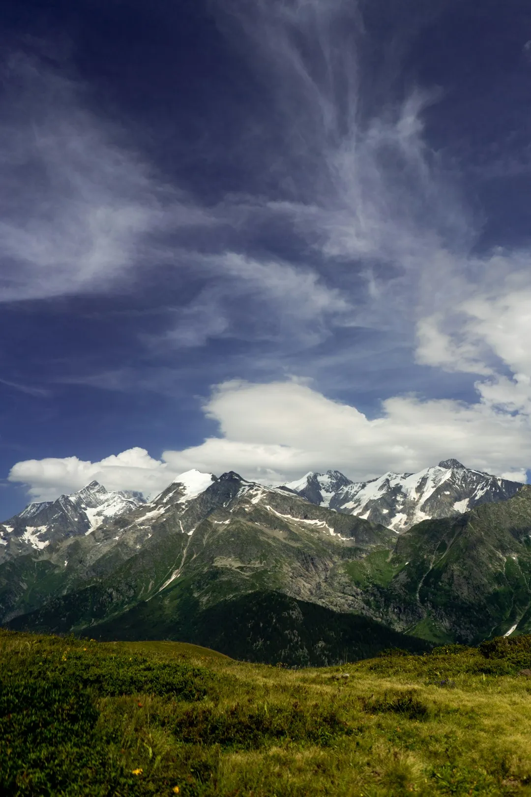
The Tour du Mont Bego, nestled within the Mercantour National Park in the Maritime Alps of France, is a captivating multi-day trek that delves into a landscape rich in both natural beauty and ancient human history. This challenging route, often referred to as the "Valley of the Marães" (Marães being the local dialect term for the ancient rock engravings), circumnavigates the imposing Mont Bego, a peak steeped in mystery and legend. The trail winds through dramatic alpine scenery, past crystal-clear lakes, over rugged passes, and through meadows carpeted with wildflowers, all while revealing a remarkable concentration of prehistoric rock art, some dating back over 5,000 years. It's a journey that combines the physical exertion of high-altitude trekking with the intellectual stimulation of exploring a unique archaeological heritage, offering a profound connection to both the natural world and the distant past.
- Distance: Approximately 40.0 km
- Elevation Gain: Approximately 2,500 m
- Duration: 3-4 days
- Difficulty: Challenging
- Best Time: June to September
- Closest City: Nice, France
- Trailhead Access: Nearest airport: Nice (NCE). From Nice, take a bus to Saint-Martin-Vésubie, then another bus or taxi to Belvédère (trailhead). Driving time ~2 hours. Road is paved but narrow in sections. Limited parking available in Belvédère. No permits needed to hike, but refuge stays require reservations. Trailhead GPS: 44.0700, 7.3400.
Overview
The Tour du Mont Bego is not merely a hike; it is an expedition into a prehistoric open-air museum. The trail is renowned for its exceptional density of rock engravings, known as "Marães," which are scattered across the landscape, particularly around the Mont Bego massif. These engravings, created by Neolithic and Bronze Age peoples, depict a fascinating array of symbols, including human figures, animals, tools, and geometric patterns, offering tantalizing glimpses into the beliefs, rituals, and daily lives of ancient inhabitants. The sheer quantity and preservation of these carvings make the area one of the most significant archaeological sites in the European Alps.
Beyond its historical significance, the Tour du Mont Bego offers a quintessential alpine trekking experience. The route ascends through varied terrain, from verdant valleys dotted with traditional stone hamlets to stark, rocky slopes and high mountain passes. Hikers will traverse landscapes sculpted by glaciers, with U-shaped valleys, moraines, and numerous glacial lakes that reflect the surrounding peaks. The flora and fauna are also a highlight, with alpine meadows bursting with colourful wildflowers in summer, and the chance to spot chamois, ibex, marmots, and a variety of alpine birds. The challenging elevation gains and descents, combined with the often rugged and exposed nature of the paths, ensure that this trek is a rewarding physical undertaking.
The trail is typically completed over three to four days, allowing ample time to explore the archaeological sites and appreciate the stunning natural environment. Accommodation is usually in mountain refuges (refuges de montagne), which provide basic but comfortable lodging and meals, offering a welcome respite after a day of hiking. The remoteness and ruggedness of the terrain contribute to the sense of adventure and discovery, making the Tour du Mont Bego a truly memorable journey for those seeking a blend of physical challenge, natural beauty, and profound historical exploration.
History and Cultural Context
The history of the Tour du Mont Bego is inextricably linked to its extraordinary rock art. The Mont Bego massif has been a place of human activity and spiritual significance for millennia. The earliest engravings date back to the late Neolithic period (around 3,000 BCE) and continued through the Bronze Age. These ancient peoples, likely pastoralists and hunters, chose this high-altitude region for reasons that remain partly speculative but are undoubtedly tied to its unique geological features and perhaps its perceived spiritual power. The symbols they etched into the rock faces—often smooth, glacially polished surfaces—are thought to represent a complex belief system, possibly related to astronomical observations, agricultural cycles, or shamanistic practices. The sheer concentration of these carvings, estimated to be over 100,000, is unparalleled in the Alps.
The area remained a significant pastoral zone throughout history, with shepherds and farmers utilizing the high pastures for grazing livestock during the summer months. Traditional stone huts and shepherd shelters, some of which have been converted into modern refuges, bear witness to this long-standing human presence. The Mercantour National Park, established in 1979, was created to protect this unique natural and cultural heritage, including the Mont Bego archaeological sites, which are now a protected UNESCO World Heritage site.
The modern trekking route, the Tour du Mont Bego, has evolved from ancient shepherd paths and pilgrimage routes. It gained popularity among hikers and archaeologists in the 20th century as the significance of the rock art became more widely recognised. Today, the trail offers a unique opportunity to walk in the footsteps of these ancient peoples, experiencing the same breathtaking landscapes that inspired their art and spiritual practices. The careful preservation of the archaeological sites, alongside the protection of the natural environment, ensures that the Tour du Mont Bego remains a vital link to our distant past.
Seasonal Highlights and Weather Reality
The hiking season for the Tour du Mont Bego is relatively short, dictated by the harsh alpine climate. The best time to undertake this trek is generally from June to September.
June: The early part of the month can still see significant snow cover at higher elevations, particularly on north-facing slopes and passes. Lakes may still be partially frozen. However, by late June, snowmelt usually opens up most of the lower and mid-altitude trails. Wildflowers begin to bloom, and the landscape starts to awaken. Weather can be unpredictable, with a risk of late snowfalls and thunderstorms.
July and August: These are the peak months for hiking. The weather is generally at its most stable, with longer daylight hours and warmer temperatures. Alpine meadows are in full bloom, creating a spectacular display of colour. This is also the busiest period, so booking accommodation in refuges well in advance is essential. Thunderstorms are common in the afternoons, so starting hikes early in the day is highly recommended.
September: The autumn colours begin to appear, offering a different kind of beauty to the landscape. The crowds thin out, and the air becomes crisp and clear. However, temperatures start to drop, and there is an increased risk of early snowfalls, especially towards the end of the month. The days are shorter, and refuges may begin to close towards the end of September.
Weather: The weather in the Mercantour National Park can change rapidly and dramatically. Even in summer, hikers can encounter strong winds, heavy rain, fog, and even snow at higher altitudes. Temperatures can fluctuate significantly between day and night. It is crucial to be prepared for all conditions, regardless of the season.
Recommended Itinerary
3-Day Tour du Mont Bego Itinerary
Day 1: Belvédère to Refuge de Nice
- Distance: Approximately 10 km
- Elevation Gain: Approximately 1,000 m
- Time: 4–5 hours
- Start from the village of Belvédère.
- Follow well-marked trails ascending through forests and then into alpine meadows.
- Pass by the ruins of old shepherd huts and the first scattered rock engravings.
- The trail gradually climbs towards the Refuge de Nice, offering increasingly expansive views of the surrounding valleys.
- Arrive at Refuge de Nice (1,900 m), a comfortable mountain refuge offering meals and accommodation.
- Spend the late afternoon exploring nearby areas and searching for early rock art sites.
Day 2: Refuge de Nice to Refuge des Merveilles
- Distance: Approximately 12 km
- Elevation Gain: Approximately 800 m
- Elevation Loss: Approximately 400 m
- Time: 5–6 hours
- This is the core day for exploring the archaeological sites.
- Ascend from Refuge de Nice towards the Col des Merveilles (2,087 m).
- The landscape opens up into a vast alpine plateau dotted with numerous lakes, including the stunning Lac des Merveilles.
- This area is the heart of the Mont Bego rock art, with thousands of engravings visible on the polished rock surfaces.
- Take ample time to explore the various sectors, such as the Vallée des Merveilles and the Vallée des Tombeaux, guided by maps or a local guide.
- Descend towards the Refuge des Merveilles (2,111 m), situated in a picturesque setting near the lake.
- The refuge is known for its unique location and proximity to significant archaeological zones.
Day 3: Refuge des Merveilles to Belvédère
- Distance: Approximately 18 km
- Elevation Gain: Approximately 700 m
- Elevation Loss: Approximately 1,300 m
- Time: 6–7 hours
- Begin with a final exploration of the rock art sites around the refuge.
- Ascend to the Col de Fenestre (2,474 m), the highest point of the trek, offering panoramic views.
- Descend through the Vallon de la Gordolasque, a beautiful glacial valley.
- The descent is long and can be steep in sections.
- Pass through varied terrain, from high alpine scree to more vegetated slopes.
- Rejoin the path leading back towards Belvédère.
- Arrive back in Belvédère in the late afternoon, completing the circuit.
Alternative 4-Day Itinerary:
For a more relaxed pace or to delve deeper into the archaeological sites, consider adding an extra day. This could involve:
- Spending a full day dedicated to exploring the Vallée des Merveilles and its surrounding areas from Refuge des Merveilles.
- Incorporating a visit to other nearby refuges or peaks for extended views and exploration.
- Breaking down the longer Day 3 descent into two shorter stages with an overnight stop at a lower-altitude refuge or a more remote bivouac spot (if permitted and equipped).
Important Notes:
- Bookings for refuges are mandatory, especially during peak season (July-August).
- Carry sufficient water or a reliable water filter, as water sources can be scarce at higher altitudes.
- Be prepared for rapidly changing weather conditions.
- Respect the archaeological sites; do not touch or disturb the rock engravings.
- Carry a detailed map and compass, and know how to use them.
Planning and Bookings
Book Your Trip
Everything you need to plan your journey
Accommodation
Find places to stay near Nice
Flights
Search flights to Nice
Essential Preparation
The Tour du Mont Bego is a challenging trek that requires careful planning and a good level of physical fitness. Given its location in the Mercantour National Park, access is primarily via the French Alps. The closest major city with an international airport is Nice (NCE). From Nice, you will need to arrange transport to the trailhead village of Belvédère. This typically involves a combination of train and bus services, or a rental car. The drive from Nice to Belvédère takes approximately 2 hours and involves winding mountain roads, so allow ample time. Belvédère itself is a small village with limited facilities, so ensure you have all necessary supplies before arriving. Accommodation in Belvédère is available in guesthouses or small hotels, and it serves as an excellent base for pre-trek preparations and post-trek relaxation. It is crucial to book accommodation in the mountain refuges along the route well in advance, especially if travelling during July and August, as they have limited capacity and are very popular.
Trail Accommodation
Accommodation along the Tour du Mont Bego is primarily in mountain refuges (refuges de montagne). These are typically basic but comfortable establishments offering dormitory-style sleeping arrangements and meals. The main refuges encountered on the standard itinerary are:
Refuge de Nice (1,900 m):
- Booking Requirements: Mandatory booking, especially during peak season. Contact the refuge directly or through national park booking systems.
- Facilities Provided: Dormitory beds with mattresses and blankets, communal dining area, toilets, washbasins, and often a warden who can provide information and assistance. Meals (dinner and breakfast) are usually available for purchase.
- What's NOT Provided: Sleeping bags (a liner is often sufficient, but a lightweight sleeping bag is recommended), toiletries, towels, cooking equipment (as meals are provided).
- Seasonal Availability: Typically open from mid-June to mid-September.
- Costs: Expect to pay approximately €40-€60 per person per night for half-board (dinner and breakfast).
Refuge des Merveilles (2,111 m):
- Booking Requirements: Mandatory booking, essential due to its prime location for archaeological exploration.
- Facilities Provided: Similar to Refuge de Nice, with dormitory beds, communal areas, toilets, and meal services. This refuge is particularly popular with archaeologists and history enthusiasts.
- What's NOT Provided: Sleeping bags, toiletries, towels, cooking equipment.
- Seasonal Availability: Typically open from mid-June to mid-September.
- Costs: Similar to Refuge de Nice, approximately €40-€60 per person per night for half-board.
Other Potential Accommodation: Depending on the chosen itinerary, other refuges like Refuge de la Gordolasque or bivouac areas (where permitted and with appropriate gear) might be options. Always check current availability and regulations.
Note on Bivouacking: Wild camping and bivouacking are generally restricted in French National Parks. Where permitted, it is usually in designated areas or with specific regulations. For the Tour du Mont Bego, relying on the refuges is the standard and recommended approach.
Required Gear
- Sturdy hiking boots: Waterproof, with good ankle support and well broken-in. Essential for navigating rocky and uneven terrain.
- Waterproof and windproof jacket: A high-quality shell jacket is crucial for protection against sudden alpine weather changes.
- Waterproof overtrousers: To keep dry during rain showers.
- Warm layers: Fleece jacket or down vest, thermal base layers (merino wool or synthetic). Temperatures can drop significantly at night and at higher altitudes.
- Hat and gloves: Even in summer, mornings and evenings can be cold.
- Backpack: A comfortable daypack (30-40 litres) for day hikes from refuges, or a larger pack (45-55 litres) if carrying all your gear for multi-day treks between refuges. A rain cover for the pack is advisable.
- Head torch: With spare batteries, for navigating in refuges or if hiking in low light.
- First-aid kit: Including blister treatment, pain relievers, antiseptic wipes, bandages, and any personal medications.
- Sun protection: High SPF sunscreen, sunglasses, and a wide-brimmed hat. The sun at altitude can be intense.
- Navigation tools: Detailed topographic map of the area (e.g., IGN 1:25,000 scale), compass, and a GPS device or smartphone with offline maps. Knowledge of how to use these is vital.
- Trekking poles: Highly recommended for stability on ascents and descents, and to reduce strain on knees.
What to Bring
- Food and snacks: While refuges provide meals, it's wise to carry high-energy snacks like nuts, dried fruit, energy bars, and chocolate for during the day's hiking.
- Water bottles or hydration reservoir: Capacity for at least 2 litres per person.
- Water purification method: A filter or purification tablets are recommended, as water sources, while plentiful, should ideally be treated.
- Toiletries: Biodegradable soap, toothbrush, toothpaste, small quick-drying towel, hand sanitiser.
- Personal items: Camera, power bank for electronics, book or journal for downtime.
- Insect repellent: Especially for mosquitoes and midges, which can be present in the valleys and around lakes.
- Cash: Refuges may not accept credit cards, so carry sufficient Euros for accommodation, meals, and any incidentals.
- Identification and travel documents: Passport, any necessary visas, and insurance details.
- Small plastic bags: For packing out all rubbish.
Permits
For hiking the Tour du Mont Bego itself, no specific hiking permits are generally required for day walks or for traversing the trails. The trails are part of the Mercantour National Park, and access is open to the public. However, the crucial aspect of "permits" for this trek relates to accommodation. Staying overnight in the mountain refuges (Refuge de Nice, Refuge des Merveilles, etc.) requires advance booking and payment. These refuges have limited capacity, and booking is essential, particularly during the peak summer months of July and August. It is advisable to book your stays in the refuges several weeks, or even months, in advance to secure your preferred dates and ensure availability.
Booking Refuges:
- Contact: Each refuge typically has its own contact details (phone number, email address) and often an online booking system or can be booked through a central park service or national alpine club website (e.g., Club Alpin Français - CAF).
- Information Needed: When booking, you will usually need to provide your name, the number of people in your party, the dates of your stay, and whether you require half-board (dinner and breakfast) or just a bed.
- Payment: Payment methods can vary, but often include bank transfer or payment upon arrival. It is wise to confirm payment procedures when booking.
- Cancellation Policy: Be aware of the cancellation policy for each refuge in case your plans change.
Archaeological Site Protection: While no permit is needed to view the rock engravings, it is imperative to treat these ancient sites with the utmost respect. Touching, climbing on, or otherwise disturbing the engraved rocks is strictly prohibited and can lead to penalties. The sites are protected by law as historical monuments.
National Park Regulations: As the trek is within the Mercantour National Park, general park regulations apply. These typically include rules about waste disposal, campfires (usually prohibited), and respecting wildlife. Familiarise yourself with the park's guidelines before your trip.
Other Activities in the Area
The Mercantour National Park and its surrounding region offer a wealth of activities beyond the Tour du Mont Bego itself, allowing for an extended and richer experience:
- Exploration of Belvédère: The charming village of Belvédère, the primary trailhead, is worth exploring. It features traditional stone architecture, narrow streets, and a picturesque setting.
- Other Hiking Trails: The Mercantour National Park is crisscrossed with numerous other hiking trails, ranging from short walks to multi-day treks. Trails leading to other peaks, lakes, or more remote valleys offer diverse landscapes and challenges.
- Wildlife Watching: The park is home to a rich variety of alpine fauna, including ibex, chamois, marmots, golden eagles, and bearded vultures. Keep an eye out for these magnificent creatures during your hikes.
- Rock Climbing: The region offers opportunities for rock climbing, with various routes catering to different skill levels.
- Via Ferrata: For those seeking a more adventurous experience, there are Via Ferrata routes in the vicinity, offering a guided climb with steel cables and ladders.
- Cultural Visits: Explore nearby villages and towns in the Maritime Alps, such as Sospel or Saorge, which offer historical sites, local markets, and regional cuisine.
- Stargazing: The remote, high-altitude locations within the Mercantour National Park offer excellent conditions for stargazing, with minimal light pollution.
- Photography: The dramatic alpine scenery, wildflowers, wildlife, and ancient rock art provide endless opportunities for stunning photography.
Safety and Conditions
Pre-Trip Preparation:
- Physical Fitness: The Tour du Mont Bego is a challenging trek with significant elevation changes and rough terrain. Ensure you are adequately fit, with good cardiovascular health and strong legs. Train by hiking with a loaded backpack on varied terrain.
- Weather Monitoring: Check the mountain weather forecast for the Mercantour region immediately before and during your trek. Websites like Météo-France provide detailed forecasts for alpine areas. Be prepared for rapid changes.
- Route Familiarisation: Study your maps and understand the route, potential hazards, and bailout points.
- Emergency Contacts: Know the emergency numbers for France (112 is the European emergency number). Inform someone of your itinerary and expected return time.
On the Trail:
- Altitude: While not extremely high, the trek reaches altitudes where altitude sickness can be a concern for some. Ascend gradually, stay hydrated, and be aware of symptoms (headache, nausea, dizziness).
- Terrain: The trails can be steep, rocky, and uneven. Wear appropriate footwear and use trekking poles for stability. Be cautious on scree slopes and in areas with loose rocks.
- Weather: Alpine weather is notoriously unpredictable. Be prepared for sun, rain, wind, and even snow, sometimes all in the same day. Hypothermia is a risk, even in summer, if you get wet and cold. Always carry waterproofs and warm layers.
- Thunderstorms: Afternoon thunderstorms are common in the Alps during summer. Start your hikes early to avoid being caught out on exposed ridges or passes during a storm. Seek shelter in a refuge or a low-lying area if a storm approaches. Avoid open ridges and isolated trees.
- Water Sources: While water is generally available from streams and lakes, it is advisable to treat all water before drinking, especially at lower altitudes or near grazing areas.
- Wildlife: While most wildlife is shy, be aware of your surroundings. Ibex and chamois are common but can be unpredictable if approached too closely.
- Archaeological Sites: The rock engravings are fragile and protected. Do not touch, climb on, or deface them. Stay on marked paths to avoid damaging the surrounding vegetation and delicate ecosystems.
- Navigation: Trails are generally well-marked, but fog or snow can obscure them. Carry and know how to use a map and compass. A GPS device or smartphone with offline maps is a valuable backup.
- Communication: Mobile phone reception can be intermittent or non-existent in many parts of the park. Consider carrying a personal locator beacon (PLB) for emergencies.
Refuge Safety: Follow the instructions of the refuge wardens. Be mindful of noise levels, especially at night, to ensure everyone can rest.
Side Trips and Points of Interest
Vallée des Merveilles and Vallée des Tombeaux: These are the primary archaeological zones and the heart of the Tour du Mont Bego experience. The Vallée des Merveilles (Valley of Wonders) is home to the vast majority of the rock engravings, with thousands of symbols etched into the polished glacial rocks. The Vallée des Tombeaux (Valley of Tombs) is named for the numerous cairns and megalithic structures found within it, suggesting ancient burial sites. Exploring these valleys requires time, patience, and a keen eye to spot the subtle carvings amidst the natural rock formations. Local guides can significantly enhance the experience by pointing out key engravings and explaining their potential meanings.
Lac des Merveilles: This stunning glacial lake is a central feature of the archaeological area and a beautiful spot to pause and reflect. Its clear waters often mirror the surrounding peaks, providing a picturesque setting for a break.
Col des Merveilles: This pass offers a transition point into the main archaeological zone and provides excellent panoramic views of the surrounding landscape.
Col de Fenestre: The highest point on the standard 3-day itinerary, this pass offers breathtaking 360-degree views of the Mercantour massif, including Mont Bego itself. It's a spectacular vantage point for photography and appreciating the vastness of the alpine environment.
Mont Bego Summit (2,872 m): For experienced and well-equipped hikers with an extra day, a summit attempt on Mont Bego is possible. This is a challenging scramble or climb requiring mountaineering skills and appropriate gear. The views from the summit are said to be spectacular, offering a commanding perspective over the entire region.
Refuge de la Gordolasque: If extending the trek or opting for a different route, this refuge provides access to further hiking opportunities and different valleys within the park.
Flora and Fauna: Keep an eye out for the diverse alpine flora, especially during the summer months when meadows are carpeted with wildflowers. The region is also excellent for spotting wildlife such as ibex, chamois, marmots, and various bird species.
Leave No Trace
The Tour du Mont Bego traverses a landscape of immense natural beauty and profound historical significance. The Mercantour National Park is a protected area, and the Mont Bego archaeological sites are a UNESCO World Heritage site. It is crucial for all visitors to adhere to Leave No Trace principles to preserve this environment for future generations.
Plan Ahead and Prepare: Research the trail, weather conditions, and refuge booking requirements well in advance. Pack appropriately for all conditions. Inform someone of your itinerary.
Travel and Camp on Durable Surfaces: Stick to marked trails to avoid damaging fragile alpine vegetation. When resting, choose durable surfaces like rock or established paths. Avoid camping outside designated areas if you are bivouacking (which is generally restricted).
Dispose of Waste Properly: Pack out everything you pack in, including all food scraps, wrappers, and any other litter. Use the toilet facilities provided in refuges. If you must go in the backcountry, dig a cathole at least 60 metres from water sources, trails, and campsites, and bury human waste. Pack out all toilet paper.
Leave What You Find: Do not remove any natural objects, such as rocks or plants. Most importantly, do not touch, climb on, or deface the ancient rock engravings. These are irreplaceable historical artifacts.
Minimize Campfire Impacts: Campfires are generally prohibited in French National Parks. Use a portable stove for cooking.
Respect Wildlife: Observe wildlife from a distance. Do not feed animals, as this can disrupt their natural behaviours and diets. Store food securely to prevent attracting animals.
Be Considerate of Other Visitors: Keep noise levels down, especially in refuges and sensitive areas. Yield to other hikers on narrow trails. Respect the tranquility of the alpine environment.