Tour du Taillefer - A High Alpine Traverse
The Tour du Taillefer is a challenging multi-day trek in the heart of the French Alps, specifically within the Taillefer massif, south of Grenoble. This route offers a true alpine experience, traversing high mountain passes, skirting glacial lakes, and passing through diverse landscapes ranging from alpine meadows to rugged scree slopes. It is a journey for experienced hikers seeking solitude and spectacular mountain scenery away from the more crowded routes. The massif is known for its wild beauty, dramatic peaks, and the pristine environment that rewards those who venture into its depths.
- Distance: Approximately 55 km
- Duration: 4–5 days
- Season: June to September (snow-free conditions)
- Difficulty: Challenging
- Highest point: Approximately 2,500 metres
- Base town: Séchilienne, near Grenoble
- Access: Public transport to Séchilienne, then taxi to trailhead at Lac du Poursollet
- Permits: Not required for general access
Overview
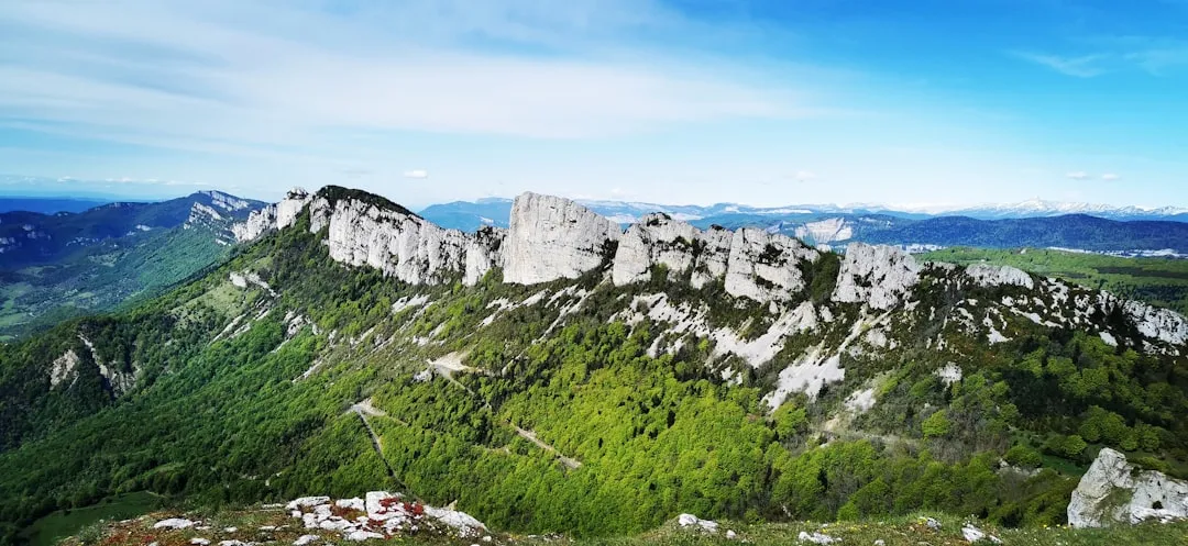
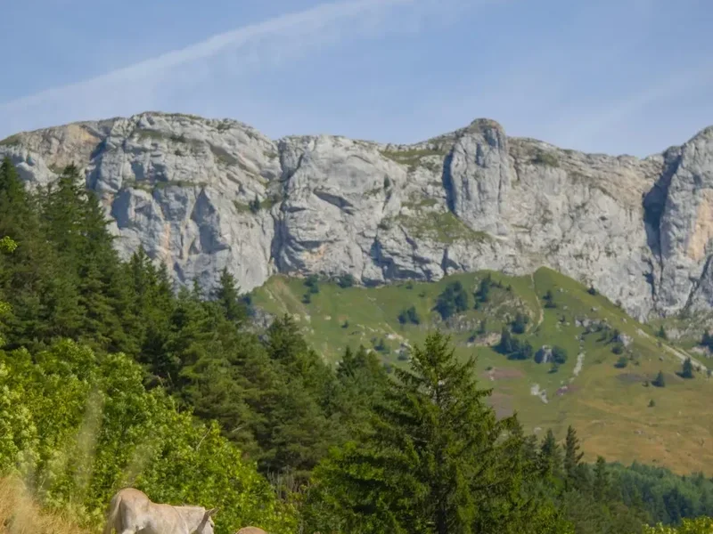
The Tour du Taillefer is a circular or linear route (depending on the chosen variation) that circumnavigates or traverses the imposing Taillefer massif. This massif, part of the Dauphiné Alps, is characterised by its granite peaks, numerous glacial lakes, and a rich biodiversity that thrives in its high-altitude environment. The trail is not as well-known as some of its more famous neighbours, which contributes to its appeal for those seeking a more remote and less commercialised hiking experience.
The terrain is demanding, with significant elevation gains and losses each day. Hikers will encounter steep ascents and descents, rocky paths, and potentially snow patches even in early summer. The reward for this effort is unparalleled: breathtaking panoramic views of the surrounding Alps, including the Écrins National Park, the Vercors, and the Chartreuse ranges. The lakes, such as Lac Fourchu, Lac de Brouffier, and Lac de Taillefer, offer stunning reflections of the surrounding peaks and provide refreshing spots for a break.
The route typically involves staying in mountain refuges (refuges de montagne) or bivouacking in designated areas, adding to the authentic alpine adventure. The flora and fauna are typical of the high Alps, with marmots, chamois, and a variety of alpine flowers often spotted by observant hikers. The air is crisp and clean, and the silence of the mountains is profound, broken only by the sounds of nature.
History and Cultural Context
The Taillefer massif has a long history of human interaction, primarily driven by pastoralism and, in more recent times, mountaineering and hiking. For centuries, local communities from the valleys below, such as those in Séchilienne and the surrounding Isère region, would have used the lower slopes for grazing livestock during the summer months. The higher reaches, however, remained largely wild and inaccessible.
The development of mountaineering in the Alps during the 19th century brought explorers and climbers to the Taillefer. Its rugged peaks, though not as high as some of the neighbouring giants, offered challenging ascents and a sense of wild frontier. Early cartographers and geologists also explored the area, mapping its terrain and studying its unique geological formations, particularly its granite composition.
The establishment of mountain refuges in the 20th century made the massif more accessible to hikers and climbers. These refuges, often managed by local alpine clubs or private individuals, provided essential shelter and sustenance, enabling longer and more ambitious treks. The Tour du Taillefer, as a defined route, likely emerged from a combination of these historical paths and the desire to create a comprehensive circuit of the massif, linking key points of interest and refuges.
Culturally, the Taillefer is deeply connected to the Dauphiné region. The villages at its base, like Séchilienne, retain traditional alpine architecture and a way of life that has been shaped by the mountains for generations. The massif itself is seen as a natural guardian of the valleys, a source of water, and a place of both challenge and beauty.
Seasonal Highlights and Weather Reality
The best time to undertake the Tour du Taillefer is from June to September. During this period, the snow generally melts from the higher passes, making the trails passable and the weather more predictable, though still highly variable.
June: Early June can still see significant snow cover at higher elevations, especially on north-facing slopes and passes. Lakes may still be partially frozen. Wildflowers begin to bloom, and the landscape is fresh and vibrant. Days are long, offering ample hiking time. However, snowmelt can lead to swollen rivers and potentially challenging stream crossings.
July and August: This is the peak season. The weather is generally at its most stable, with warm days and cool nights. Wildflowers are in full bloom, creating a spectacular display of colour. The refuges are fully operational and can be busy, especially on weekends. This is the most reliable time for snow-free conditions on the entire route.
September: Autumn colours begin to appear in the lower valleys, and the air becomes crisp and clear. The crowds thin out, offering a more tranquil experience. However, the weather can become more unpredictable, with a higher chance of early snowfalls, particularly towards the end of the month. Days are shorter, requiring careful planning of hiking times.
Weather: The Alps are notorious for rapidly changing weather. Even in summer, hikers can experience sunshine, heavy rain, thunderstorms, hail, and even snow within a single day. Temperatures can drop significantly at higher altitudes, especially at night. It is crucial to be prepared for all conditions, regardless of the season.
Recommended Itinerary
4-Day Tour du Taillefer Itinerary
Day 1: Lac du Poursollet to Refuge de Taillefer
- Distance: Approximately 12 km
- Elevation gain: Approximately 1,000 m
- Time: 5–6 hours
- Start at Lac du Poursollet (1,700 m)
- Ascend through forests and then open alpine terrain
- Pass by Lac Fourchu
- Reach the Refuge de Taillefer (2,300 m)
- This day involves a significant climb to acclimatise to the altitude and terrain. The views from the refuge are spectacular.
Day 2: Refuge de Taillefer to Refuge de la Pra
- Distance: Approximately 15 km
- Elevation gain: Approximately 800 m
- Elevation loss: Approximately 1,000 m
- Time: 6–7 hours
- Cross the high passes of the massif
- Pass by Lac de Brouffier and Lac de Taillefer
- Descend towards the Refuge de la Pra (2,050 m)
- A day of high mountain traverses, offering continuous panoramic views.
Day 3: Refuge de la Pra to Refuge de Roche Clouze
- Distance: Approximately 14 km
- Elevation gain: Approximately 900 m
- Elevation loss: Approximately 700 m
- Time: 6–7 hours
- Continue traversing the massif, potentially via the Col de la Vache
- Pass through varied landscapes, including rocky ridges and alpine meadows
- Reach the Refuge de Roche Clouze (2,100 m)
- This day offers a mix of challenging ascents and descents, with opportunities to explore smaller lakes and viewpoints.
Day 4: Refuge de Roche Clouze to Lac du Poursollet
- Distance: Approximately 14 km
- Elevation gain: Approximately 500 m
- Elevation loss: Approximately 900 m
- Time: 5–6 hours
- Descend from the high mountains back towards the starting point
- Pass by Lac de Brouffier again or take an alternative route
- Return to Lac du Poursollet (1,700 m)
- A final day of descent, allowing for reflection on the journey through the wild Taillefer massif.
Alternative 5-Day Itinerary: For a more relaxed pace or to explore more side trips, consider adding an extra day, perhaps splitting the longest day or allowing for a full day of exploration around one of the refuges.
Important Notes:
- Refuge bookings are essential, especially during peak season (July-August).
- The itinerary is a suggestion and can be adapted based on weather, fitness, and personal preference.
- Carry sufficient water or a reliable water filter, as water sources can be scarce in some sections.
- Be prepared for rapid weather changes.
Planning and Bookings
Book Your Trip
Everything you need to plan your journey
Accommodation
Find places to stay near Grenoble
Flights
Search flights to Grenoble
Essential Preparation
The Tour du Taillefer is a demanding trek that requires careful planning and a good level of physical fitness. Given its remote location and challenging terrain, preparation is key to a safe and enjoyable experience. The closest major city is Grenoble, which serves as the primary gateway for accessing the region. From Grenoble, you can take public transport (bus line 6020) to the village of Séchilienne. From Séchilienne, a taxi is generally required to reach the trailhead at Lac du Poursollet, as public transport options are limited beyond the village. Driving is also an option, with approximately one hour of travel time from Grenoble to Lac du Poursollet. The road is paved but can be narrow and winding in sections, especially as you approach the lake.
It is highly recommended to book accommodation in refuges well in advance, particularly if you plan to hike during July or August. Many refuges operate on a half-board basis (dinner, bed, and breakfast), which simplifies logistics. Ensure you have a reliable map and compass, and consider carrying a GPS device or using a navigation app with offline maps. Inform someone of your itinerary and expected return date.
Trail Accommodation
Accommodation on the Tour du Taillefer primarily consists of mountain refuges (refuges de montagne). These are typically basic but comfortable establishments offering dormitory-style sleeping arrangements and meals. Some sections may also allow for wild camping in designated areas or with specific permissions, but refuges are the standard and recommended option for this trek.
Refuge de Taillefer: Located at approximately 2,300 metres, this refuge offers stunning views and is a common starting or ending point for the trek. It provides dormitory beds and serves meals. Booking is essential.
Refuge de la Pra: Situated at around 2,050 metres, this refuge is another key stop on the route, often offering a picturesque setting near a lake. It also provides dormitory accommodation and meals. Advance booking is highly recommended.
Refuge de Roche Clouze: At approximately 2,100 metres, this refuge is typically part of the circuit, offering a place to rest and refuel. Similar to other refuges, booking is advised.
Booking Requirements: Refuges can usually be booked directly via their websites or by telephone. It is advisable to book several weeks or even months in advance for peak season. Many refuges offer half-board options (dîner, coucher, petit-déjeuner), which is convenient for multi-day treks.
Facilities Provided: Dormitory beds with blankets or duvets, common dining areas, and often basic toilet facilities. Some may have showers, but this is not guaranteed.
What's NOT Provided: Sleeping bags (a liner is often mandatory), toiletries, towels, cooking equipment (unless you are camping), and food outside of the provided meals.
Seasonal Availability: Refuges are typically open from June to September/October, depending on snow conditions and demand. Outside these months, they are usually closed and unstaffed.
Costs: Prices vary but expect to pay approximately €40-€60 per person per night for half-board. Dormitory beds alone are cheaper.
Required Gear
- Sturdy hiking boots: Waterproof, well broken-in, with good ankle support. Essential for the rocky and uneven terrain.
- Waterproof and windproof jacket: Gore-Tex or similar, with taped seams. Crucial for protection against sudden alpine weather changes.
- Waterproof overtrousers: Full-length zips are beneficial for ease of use.
- Warm layers: Fleece jacket or down vest, thermal base layers (merino wool or synthetic).
- Hat and gloves: Even in summer, temperatures can drop significantly at altitude.
- Backpack: 40-60 litre capacity, with a comfortable harness and hip belt. A rain cover is essential.
- Sleeping bag liner: Often mandatory in refuges for hygiene.
- Head torch: With spare batteries, for use in refuges and for early morning starts.
- First-aid kit: Including blister treatment, pain relievers, antiseptic wipes, bandages, and any personal medications.
- Navigation tools: Detailed topographic map of the area, compass, and optionally a GPS device or smartphone with offline maps.
- Sun protection: High SPF sunscreen, sunglasses, and a wide-brimmed hat.
What to Bring
- Food: While refuges offer meals, carry high-energy snacks such as nuts, dried fruit, energy bars, and chocolate for lunches and in-between meals.
- Water: Carry at least 1.5-2 litres of water per person. Water sources are available along the route, but a reliable water filter or purification tablets are highly recommended.
- Toiletries: Biodegradable soap, toothbrush, toothpaste, small towel, toilet paper, hand sanitiser.
- Personal items: Camera, power bank for electronics, book or journal, trekking poles (highly recommended for ascents and descents).
- Cash: Some refuges may not accept credit cards, so carry sufficient Euros for accommodation, meals, and any incidentals.
- Emergency whistle: For signalling in case of emergency.
- Duct tape: Useful for quick repairs to gear.
Permits
The Tour du Taillefer does not typically require specific permits for general hiking and access to the trails. The area is part of the French Alps and is generally open to the public for recreational use. However, it is important to note the following:
- Refuge Bookings: As mentioned in the accommodation section, booking your stay in mountain refuges is crucial and effectively acts as your "permit" for overnight stays in these facilities. These bookings should be made directly with the individual refuges well in advance.
- Wild Camping: Wild camping is generally discouraged or prohibited in many parts of the French Alps, especially within national parks or sensitive ecological zones. While some areas might permit bivouacking (a single night's sleep in a lightweight tent or bivy bag) under specific conditions (e.g., arriving late, leaving early, not making a fire, and being above the tree line), it is essential to check local regulations or consult with local authorities or the park rangers if you intend to camp outside of designated areas. The refuges are the primary and most convenient accommodation option.
- National Park Regulations: While the Taillefer massif may not be within a strictly designated national park like the Écrins, it is still a protected natural environment. Hikers are expected to adhere to general principles of respecting nature, such as staying on marked trails, not disturbing wildlife, and not leaving any litter.
Always check for any local notices or advisories posted at trailheads or in nearby villages before you begin your trek. The emphasis for this route is on responsible hiking and respecting the mountain environment.
Other Activities in the Area
The region surrounding the Taillefer massif offers a wealth of activities for outdoor enthusiasts, allowing for extensions to your hiking trip or alternative adventures:
- Climbing and Mountaineering: The Taillefer massif itself, along with the nearby Écrins National Park, provides numerous opportunities for rock climbing and more technical mountaineering routes for experienced individuals.
- Via Ferrata: Several via ferrata routes are accessible in the broader Grenoble region, offering a thrilling way to experience cliff faces with the aid of steel cables, ladders, and bridges.
- Mountain Biking: The lower slopes and valleys around Grenoble boast an extensive network of mountain biking trails, catering to various skill levels.
- Canyoning: The numerous rivers and gorges in the Dauphiné Alps are ideal for canyoning, a sport that involves descending through canyons using techniques such as abseiling, jumping, and swimming.
- Paragliding: The thermals and dramatic landscapes around Grenoble make it a popular spot for paragliding, offering spectacular aerial views of the Alps.
- Exploring Grenoble: The vibrant city of Grenoble offers cultural attractions, including museums, historic architecture, and a lively culinary scene. The Bastille fortress, accessible by cable car, provides panoramic views of the city and surrounding mountains.
- Day Hikes: Numerous shorter day hikes are available in the foothills of the Taillefer and in adjacent massifs, offering a taste of alpine scenery without the commitment of a multi-day trek.
Safety and Conditions
Weather: The most significant safety concern on the Tour du Taillefer is the unpredictable alpine weather. Conditions can change rapidly, with sudden storms, heavy rain, thunderstorms, and even snow possible at any time, even in summer. Always check the mountain forecast before setting out and be prepared to alter your plans if necessary. Hypothermia is a risk, even in warmer months, due to altitude and wind chill.
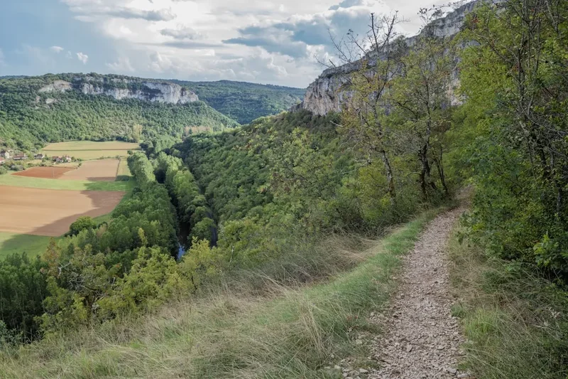
Terrain: The trail is challenging, involving steep ascents and descents, rocky paths, scree slopes, and potentially snowfields. Good quality hiking boots with ankle support are essential. Trekking poles can significantly aid stability and reduce strain on joints.
Navigation: While the main trails are generally marked, the terrain can be complex. Carry a detailed topographic map and compass, and know how to use them. A GPS device or smartphone with offline maps is a valuable backup. Do not rely solely on electronic devices, as batteries can fail, and signal may be lost.
Water: Water sources can be intermittent, especially at higher altitudes. Carry sufficient water and a reliable water filter or purification tablets. Treat all water from natural sources.
Altitude: The trek reaches significant altitudes (up to around 2,500 metres). Be aware of the symptoms of altitude sickness, such as headache, nausea, and dizziness. Ascend gradually, stay hydrated, and avoid overexertion. If symptoms persist or worsen, descend.
Wildlife: While generally not dangerous, be aware of local wildlife. Marmots are common, and you might see chamois or ibex. Respect their space and do not attempt to feed them.
Refuge Safety: Follow the rules and guidelines provided by refuge wardens. Ensure you have adequate sleeping gear and are aware of emergency procedures.
Emergency Contact: In case of emergency, the general European emergency number is 112. Ensure you have a fully charged mobile phone, though reception can be unreliable in remote mountain areas. Consider carrying a personal locator beacon (PLB) for remote treks.
Insurance: Ensure you have travel insurance that covers hiking and potential mountain rescue.
Side Trips and Points of Interest
The Tour du Taillefer offers several opportunities for rewarding side trips and exploration beyond the main circuit:
Lac Fourchu: A beautiful alpine lake often visited on the first day of the trek. Its clear waters and surrounding scenery make it an ideal spot for a break and photography.
Lac de Brouffier: Another stunning glacial lake, often encountered on Day 2 or Day 4. Its location provides excellent views of the surrounding peaks and a tranquil setting.
Lac de Taillefer: This larger lake, situated at a lower altitude, is a significant landmark. Depending on the chosen route, it can be a destination in itself or a point of reference during the trek.
Summit of Taillefer (2,857 m): For experienced and fit hikers with good weather, a challenging ascent to the summit of Pic de Taillefer is a possible, albeit demanding, side trip. This would likely require an extra day or a very long and strenuous day from one of the refuges. The panoramic views from the summit are said to be exceptional.
Col de la Vache: A high pass that may be part of the route or an optional detour, offering expansive views across the massif and towards neighbouring mountain ranges.
Flora and Fauna: Keep an eye out for the diverse alpine flora, including gentians, edelweiss (though rare), and various wildflowers. Marmots are frequently seen and heard, and with luck, you might spot chamois or ibex on the higher slopes.
Leave No Trace
The Tour du Taillefer traverses a fragile alpine environment. Adhering to Leave No Trace principles is paramount to preserving its beauty and ecological integrity for future generations. As you hike, remember:
- Plan Ahead and Prepare: Research your route, understand the conditions, and pack appropriately. Book refuges in advance to avoid disappointment and overcrowding.
- Travel and Camp on Durable Surfaces: Stick to marked trails to avoid damaging vegetation. If camping is permitted in specific areas, use established sites or durable surfaces like rock or gravel. Avoid camping near water sources.
- Dispose of Waste Properly: Pack out everything you pack in, including all food scraps, wrappers, and toilet paper. Use designated toilets in refuges. If wild camping, bury human waste at least 15 cm deep and 60 m (60 metres) away from water, camp, and trails, and pack out toilet paper.
- Leave What You Find: Do not remove rocks, plants, or any natural objects. Take only photographs and memories.
- Minimize Campfire Impacts: Campfires are generally prohibited in alpine environments due to the risk of wildfires and damage to vegetation. Use a portable stove for cooking.
- Respect Wildlife: Observe wildlife from a distance. Never feed animals, as it can harm their health, alter their natural behaviours, and expose them to predators and other dangers.
- Be Considerate of Other Visitors: Keep noise levels down, yield to others on the trail, and respect the solitude of the mountains.
By following these principles, you help ensure that the wild beauty of the Taillefer massif remains intact.