Tour du Queyras - Alpine Majesty in the Southern Alps
The Tour du Queyras is a spectacular multi-day trek circumnavigating the Queyras Regional Natural Park in the Hautes-Alpes department of France. This challenging yet immensely rewarding route winds through a landscape of dramatic alpine peaks, verdant valleys, and traditional mountain villages, offering a profound immersion into the heart of the Southern Alps. Covering approximately 117 kilometres with a significant elevation gain of 7,500 metres, the Tour du Queyras is a journey for seasoned hikers seeking an authentic mountain experience far from the crowds.
The trail traverses a diverse terrain, from high mountain passes offering panoramic vistas to ancient forests and meadows carpeted with wildflowers. It connects a string of picturesque villages, each with its own unique charm and history, where walkers can experience local culture and cuisine. The route is designed to showcase the raw beauty and rugged character of the Queyras, a region renowned for its preserved natural environment and rich heritage.
- Distance: 117.0 km
- Elevation Gain: 7,500 m
- Duration: 8–12 days
- Difficulty: Challenging
- Best Time: June to September (July and August ideal)
- Closest City: Briançon
- Trailhead Access: Nearest airport: Turin (Italy). From Turin, take a train to Briançon (France). From Briançon, a bus or taxi is required to reach Ceillac (trailhead). Road conditions are generally good, but check before travel. Parking is available in Ceillac. No permits are required for the Tour du Queyras.
- Coordinates: 44.7700, 6.8000
Overview
The Tour du Queyras is a circular trek that offers an unparalleled exploration of one of France's most beautiful and least-spoiled mountain regions. It is a route that demands a good level of fitness and hiking experience due to its considerable distance and substantial elevation changes. The trail is not technically difficult in terms of climbing, but the cumulative ascent and descent over multiple days require stamina and resilience.
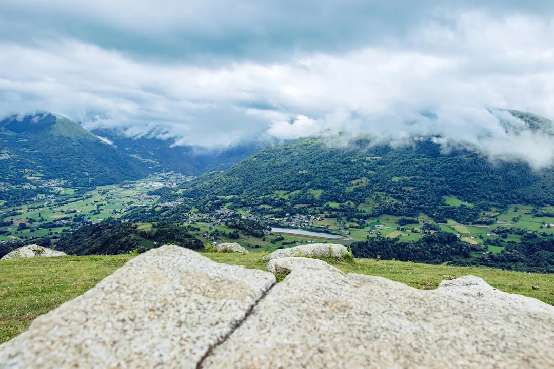
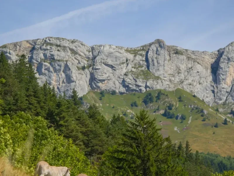
The journey begins in Ceillac, a charming village nestled in a high valley, and typically proceeds in a counter-clockwise direction. The initial stages often involve ascending to high mountain passes, such as the Col des Aiguilles or the Col de Longet, which provide breathtaking views of the surrounding peaks and valleys. These passes are often dotted with small alpine lakes, reflecting the dramatic skies above.
As the trek progresses, walkers will encounter a variety of landscapes. You'll traverse open alpine meadows, often bursting with colourful wildflowers during the summer months, and pass through dense pine and larch forests. The trail frequently follows ancient mule tracks and shepherd paths, many of which have been used for centuries, connecting remote hamlets and villages.
The villages of the Queyras, such as Saint-Véran (one of the highest villages in Europe), Molines-en-Queyras, and Abriès, are integral to the experience. These settlements are characterised by their distinctive stone houses with slate roofs, narrow winding streets, and a palpable sense of history. They offer opportunities for rest, resupply, and a taste of local Savoyard culture and cuisine.
The Tour du Queyras is a true alpine adventure, offering a deep connection with nature and a glimpse into a traditional way of life that has endured in these mountains. The remoteness of the region, combined with its stunning natural beauty, makes it a highly sought-after destination for those seeking an authentic and challenging hiking experience.
History and Cultural Context
The Queyras region has a long and rich history, deeply intertwined with its mountainous terrain and strategic location. For centuries, the valleys of the Queyras served as important transit routes, connecting the Dauphiné region of France with Piedmont in Italy. This strategic importance led to the construction of numerous fortifications, most notably the Fort Queyras, a formidable citadel perched on a rocky outcrop overlooking the valley, and the various forts along the border, such as the Fort de Mont-Dauphin (a UNESCO World Heritage site, though slightly outside the immediate Queyras park boundaries but historically significant to the region's defence).
The traditional economy of the Queyras was based on agriculture, pastoralism, and forestry. The steep slopes and harsh climate necessitated ingenious farming techniques, with terraced fields and hardy crops. The practice of transhumance, moving livestock between summer pastures in the high Alps and wintering grounds in lower valleys, was a cornerstone of life here for generations. This pastoral heritage is still visible today in the numerous mountain huts (cabanes) and the continued presence of grazing animals.
The villages themselves are living museums of alpine architecture. The distinctive stone houses, often with wooden balconies and slate roofs, are designed to withstand the harsh winters and heavy snowfall. The use of local materials and traditional building techniques reflects a deep understanding of the environment and a commitment to sustainability that predates modern environmentalism.
In the 20th century, the Queyras began to attract attention for its natural beauty and potential for tourism. The establishment of the Parc Naturel Régional du Queyras in 1977 was a crucial step in preserving its unique landscape and cultural heritage. The park's mission is to protect the environment while promoting sustainable development and traditional ways of life. The Tour du Queyras itself follows ancient paths that were once the arteries of this mountain community, connecting isolated hamlets and facilitating trade and social interaction.
Today, the Queyras strives to balance the preservation of its heritage with the needs of modern visitors. The Tour du Queyras offers a way to experience this balance, walking through landscapes shaped by both nature and human history, and encountering communities that have maintained their traditions in the face of time and change.
Seasonal Highlights and Weather Reality
The best time to undertake the Tour du Queyras is generally from June to September. During these months, the weather is typically more stable, and the snow has receded from the higher passes, making the trails accessible.
June: Early June can still see significant snow cover on the higher passes, particularly on north-facing slopes. While lower trails are usually clear, some higher sections might be impassable or require snow gear and navigation skills. Wildflowers begin to bloom, and the landscape is fresh and vibrant. Days are long, offering ample time for hiking.
July and August: These are the peak months for hiking in the Queyras. The weather is generally warm and sunny, with long daylight hours. Wildflowers are at their most abundant, creating spectacular displays of colour in the alpine meadows. This is also the busiest period, with more hikers on the trails and in the villages. The higher passes are reliably snow-free, making the entire circuit accessible.
September: September offers a beautiful autumn experience in the Queyras. The larch trees turn golden, creating a stunning contrast with the evergreen pines and the rugged grey rock. The air is crisp and clear, and the crowds have thinned considerably. While the weather can be more unpredictable, with a higher chance of cooler temperatures and occasional rain or early snow, it remains an excellent time for hiking for those who appreciate the autumn colours and solitude.
Weather Considerations:
The Alps are known for their rapidly changing weather. Even in summer, it is essential to be prepared for all conditions. Daytime temperatures can be pleasant, but nights at higher altitudes can be cold. Afternoon thunderstorms are common, especially in July and August, and can bring heavy rain, hail, and lightning. It is crucial to start your hiking days early to avoid these storms and to always carry waterproof and warm layers.
Snowfall: Early or late season snow can make higher passes treacherous. Always check local conditions and forecasts before setting out, especially if planning to hike in June or September.
Recommended Itinerary
8-Day Tour du Queyras Itinerary (Challenging Pace)
Day 1: Ceillac to Refuge de la Blanche
- Distance: 12 km
- Elevation gain: 1,000 m
- Time: 5–6 hours
- Start in Ceillac (1,650 m)
- Ascend through forests and alpine meadows
- Pass the Cascades de la Pisse
- Reach Refuge de la Blanche (2,650 m)
- Stunning views of the surrounding peaks
Day 2: Refuge de la Blanche to Refuge Agnel
- Distance: 15 km
- Elevation gain: 800 m, Elevation loss: 700 m
- Time: 6–7 hours
- Cross the Col des Aiguilles (2,875 m)
- Descend towards the Col d'Urine (2,770 m)
- Continue to Refuge Agnel (2,550 m)
- Pass by the Lac Agnel
Day 3: Refuge Agnel to Refuge de la Bonette
- Distance: 14 km
- Elevation gain: 900 m, Elevation loss: 750 m
- Time: 6–7 hours
- Ascend to the Col de Longet (2,700 m)
- Cross into Italy briefly before returning to France
- Reach Refuge de la Bonette (2,400 m)
- Views of the imposing Mont Viso
Day 4: Refuge de la Bonette to Refuge de la Monta
- Distance: 16 km
- Elevation gain: 700 m, Elevation loss: 850 m
- Time: 6–7 hours
- Traverse high alpine terrain
- Pass several small lakes
- Descend towards the valley of Abriès
- Arrive at Refuge de la Monta (1,970 m)
Day 5: Refuge de la Monta to Refuge de Furfande
- Distance: 13 km
- Elevation gain: 800 m
- Time: 5–6 hours
- Ascend towards the Col de la Lauze (2,670 m)
- Continue to Refuge de Furfande (2,080 m)
- Enjoy views of the Crête de la Taillante
Day 6: Refuge de Furfande to Refuge de la Blanche (return)
- Distance: 15 km
- Elevation gain: 700 m, Elevation loss: 600 m
- Time: 6–7 hours
- Retrace steps over some terrain, but with different perspectives
- Cross the Col de la Pare (2,650 m)
- Return to Refuge de la Blanche (2,650 m)
Day 7: Refuge de la Blanche to Ceillac
- Distance: 12 km
- Elevation loss: 1,000 m
- Time: 4–5 hours
- Descend from Refuge de la Blanche back to Ceillac
- Enjoy a final descent through the valley
- Opportunity to relax and celebrate the completion of the trek
Day 8: Rest Day or Departure from Ceillac
- A buffer day for rest, exploring Ceillac, or for potential weather delays.
- Departure from Ceillac.
Note: This is a challenging itinerary. A slower pace of 10-12 days is recommended for most walkers, allowing for more relaxed days, exploration of side trips, and buffer time for weather.
Planning and Bookings
Book Your Trip
Everything you need to plan your journey
Accommodation
Find places to stay near Briançon
Flights
Search flights to Briançon
Essential Preparation
The Tour du Queyras is a demanding trek that requires careful planning. Given its remote location and the need to stay in mountain refuges, booking accommodation well in advance is crucial, especially during the peak summer months of July and August. The refuges are often small and popular, and they can fill up quickly.
Fitness: The trek involves significant daily elevation gains and losses, often over rugged terrain. A high level of cardiovascular fitness and leg strength is essential. Regular hiking with a weighted pack, including hill training, is highly recommended in the months leading up to your trip. Familiarity with using hiking poles is also beneficial for stability and reducing strain on joints.
Logistics: The nearest major city is Briançon, which is accessible by train from major French cities like Paris and Lyon, or from Turin in Italy. From Briançon, you will need to arrange transport to Ceillac, the primary trailhead. This can be done via local bus services (check schedules carefully, as they can be infrequent, especially outside peak season) or by taxi. If driving, parking is available in Ceillac, but it's advisable to confirm availability and any associated costs.
Base Town/City Information: Briançon is a historic fortified city with a UNESCO World Heritage site Vauban citadel. It offers a full range of services, including accommodation, restaurants, supermarkets, and outdoor gear shops. It's a good place to spend a night before or after your trek to finalise preparations or relax.
Trail Accommodation
The Tour du Queyras primarily utilises a network of mountain refuges (refuges de montagne) and some gîtes d'étape (hiker's lodges) in the villages. These provide basic but comfortable accommodation for trekkers.
Refuges:
- Booking Requirements: Mandatory booking is highly recommended, and often essential, especially during July and August. Bookings can usually be made directly with the refuge via telephone or email. Some refuges may have online booking systems.
- Facilities Provided: Dormitory-style sleeping in bunk beds (bring your own sleeping bag liner), communal dining areas, and often a terrace with views. Most refuges offer half-board (demi-pension), which includes dinner and breakfast. Showers may be available, sometimes with limited hot water.
- What's NOT Provided: Towels, toiletries, sleeping bags (only liners are required), and personal items. Food beyond half-board must be carried or purchased in villages.
- Seasonal Availability: Refuges typically operate from mid-June to mid-September, depending on snow conditions and demand. Some may open earlier or close later. Always check their specific operating dates.
- Costs: Expect to pay approximately €40-€60 per night for half-board, with variations between refuges.
Gîtes d'étape:
Found in villages like Ceillac, these offer a similar experience to refuges but may have private rooms available in addition to dormitories. They often have more comprehensive facilities, including kitchens for self-catering if desired, and are generally open for longer periods.
Campsites: Wild camping is generally discouraged or prohibited in the Parc Naturel Régional du Queyras to protect the fragile environment. Designated campsites may be available in some villages, but they are not a primary feature of the Tour du Queyras route itself.
Required Gear
- Sturdy Hiking Boots: Waterproof, broken-in, with good ankle support. Essential for navigating varied and sometimes rough terrain.
- Backpack: A 40-60 litre capacity pack is suitable for carrying essentials, clothing, food, and water. Ensure it has a comfortable hip belt and adjustable straps. A rain cover is highly recommended.
- Waterproof Jacket and Trousers: Gore-Tex or similar breathable, waterproof material. Weather can change rapidly in the mountains, and rain is common even in summer.
- Warm Layers: Fleece jacket or down vest, thermal base layers (merino wool or synthetic), and a warm hat and gloves. Temperatures can drop significantly at higher altitudes, especially at night.
- Navigation Tools: Detailed topographic maps of the Queyras region (e.g., IGN 1:25,000 scale), a compass, and a GPS device or smartphone with offline mapping capabilities. Familiarity with map and compass navigation is vital.
- Head Torch: With spare batteries. Useful for navigating refuges in the dark or for early morning starts.
- First-Aid Kit: Comprehensive kit including blister treatment, pain relievers, antiseptic wipes, bandages, and any personal medications.
- Sun Protection: High SPF sunscreen, sunglasses, and a wide-brimmed hat. The sun at altitude is intense.
- Trekking Poles: Highly recommended for stability on ascents and descents, and to reduce strain on knees.
What to Bring
- Food Supplies: While refuges offer half-board, you will need to carry lunches for each day's hike, plus snacks. Consider energy bars, dried fruit, nuts, and sandwiches. Some villages along the route have small shops for resupply.
- Water Bottles/Hydration Reservoir: Capacity for at least 2 litres per person. Water sources are generally available along the trail, but treatment (filter or purification tablets) is recommended.
- Toiletries: Biodegradable soap, toothbrush, toothpaste, small quick-drying towel, toilet paper (some refuges may not provide it), hand sanitiser.
- Sleeping Bag Liner: Essential for hygiene in refuge dormitories.
- Personal Items: Camera, power bank for electronics, book or journal, insect repellent (especially for lower altitudes and evenings).
- Cash: Many refuges and small village shops may not accept credit cards, so carry sufficient Euros for accommodation, food, and any unexpected expenses.
- Duct Tape and Cord: Useful for emergency repairs to gear.
Permits
For the Tour du Queyras itself, no specific permits are required to hike the trails. The route traverses public land and passes through the Parc Naturel Régional du Queyras, which manages access and conservation efforts but does not impose a permit system for general trekking.
However, it is important to note the following:
- Accommodation Bookings: As mentioned in the Planning section, booking accommodation in mountain refuges and gîtes d'étape is essential, especially during the peak season (July-August). This is not a permit, but a reservation system to ensure you have a place to stay.
- Wild Camping: Wild camping is generally not permitted within the Parc Naturel Régional du Queyras. Designated campsites are rare along the route. Hikers are expected to stay in official accommodation. If you do encounter areas where camping might be tolerated (e.g., very remote, far from trails and villages), it should be done with extreme care, leaving no trace, and respecting local regulations. It is always best to confirm with local park authorities or tourist offices.
- National Park Regulations: While no specific trekking permit is needed, all visitors are expected to adhere to the rules and guidelines of the Parc Naturel Régional du Queyras. This includes respecting the natural environment, not disturbing wildlife, not picking flowers, and packing out all rubbish.
Recommendation: Always check the official website of the Parc Naturel Régional du Queyras or contact local tourist information offices for the most up-to-date information regarding regulations, trail conditions, and accommodation availability before your trip.
Other Activities in the Area
The Queyras region offers a wealth of activities beyond the main Tour du Queyras trek, allowing visitors to extend their stay and explore the diverse offerings of this alpine paradise.
- Day Hikes: Numerous shorter trails branch off the main Tour du Queyras route, leading to stunning viewpoints, glacial lakes, or remote hamlets. Popular day hikes include ascents to peaks like the Pic de Caramantran or explorations around the Lac Miroir and Lac Sainte-Marguerite.
- Via Ferrata: For those seeking a more adventurous experience, the Queyras has several well-equipped via ferrata routes, offering a thrilling way to ascend rock faces with the aid of cables, ladders, and bridges.
- Climbing: The region boasts excellent rock climbing opportunities, with routes catering to various skill levels, from beginner crags to challenging multi-pitch ascents.
- Mountain Biking: Dedicated mountain bike trails and routes crisscross the region, offering exhilarating descents and scenic climbs for cyclists.
- Cultural Exploration: Visit the historic villages like Saint-Véran, known for its traditional architecture and astronomical observatory, or explore the fortifications of Fort Queyras. Learn about the local history, crafts, and traditions.
- Photography: The dramatic landscapes, vibrant wildflowers, and charming villages provide endless opportunities for photographers. The clear alpine light and stunning vistas are particularly rewarding.
- Stargazing: Saint-Véran is recognised as one of the best places in Europe for stargazing due to its high altitude and low light pollution. The park often organises astronomical events and guided tours.
- Winter Sports: In winter, the Queyras transforms into a popular destination for skiing (downhill and cross-country), snowshoeing, and ski touring, offering a different perspective on the majestic mountain scenery.
Safety and Conditions
Weather: Alpine weather is notoriously unpredictable. Be prepared for rapid changes, including sudden storms, rain, hail, and significant temperature drops, even in summer. Always check the mountain forecast before setting out each day and be ready to adjust your plans. Afternoon thunderstorms are common and can be dangerous at high altitudes.
Terrain: The Tour du Queyras involves hiking on well-maintained trails, but also on rocky, uneven, and sometimes steep paths. Good quality hiking boots with ankle support are essential. Trekking poles can significantly improve stability and reduce the impact on your knees.
Altitude: While the Tour du Queyras does not reach extreme altitudes, some passes are over 2,800 metres. Be aware of the symptoms of altitude sickness, although it is less common at these elevations than on much higher peaks. Stay hydrated and ascend gradually.
Water: Water sources are generally available along the trail, particularly near streams and in villages. However, it is always advisable to treat water from natural sources using a filter or purification tablets to avoid gastrointestinal issues.
Navigation: While the main trails are generally well-marked, it is crucial to carry and know how to use a map and compass. GPS devices or smartphone apps with offline maps are excellent supplementary tools, but should not be relied upon solely. Fog or snow can obscure trails, making navigation challenging.
Communication: Mobile phone reception can be intermittent or non-existent in many parts of the Queyras, especially in valleys and at higher elevations. Consider carrying a personal locator beacon (PLB) or satellite messenger for emergencies, particularly if hiking solo or in remote sections.
Refuge Safety: Follow the rules and guidelines provided by refuge wardens. Be mindful of fire safety, especially when using gas stoves. Ensure your sleeping area is tidy and respect the quiet hours.
Emergency Contacts: Know the emergency numbers for France (112 is the European emergency number). Inform someone of your itinerary and expected return date.
Wildlife: While large predators are rare, be aware of potential encounters with marmots, chamois, or ibex. Do not feed wild animals. Insects, particularly mosquitoes and horseflies, can be present, especially in lower valleys and near water sources during warmer months. Carry insect repellent.
Side Trips and Points of Interest
The Tour du Queyras is rich with opportunities for exploration beyond the main circuit. These side trips offer a chance to delve deeper into the region's natural beauty and cultural heritage.
Lac Miroir and Lac Sainte-Marguerite: These two stunning alpine lakes are located near the village of Saint-Véran. Lac Miroir, with its crystal-clear waters, offers spectacular reflections of the surrounding Pic de Caramantran. Lac Sainte-Marguerite is a larger, more serene lake. Both are easily accessible via well-marked trails and are popular destinations for day hikes.
Pic de Caramantran: For experienced hikers seeking a summit challenge, the ascent to Pic de Caramantran (3,025 m) offers panoramic views of the Queyras, the Italian Alps, and the distant Mont Viso. The route typically starts from near Saint-Véran and involves a significant climb over rocky terrain.
Cascades de la Pisse: Located near Ceillac, these impressive waterfalls are a beautiful natural spectacle. The trail to the cascades is relatively easy and accessible, making it a perfect short excursion from the village or an early stop on the main trek.
Fort Queyras: This imposing 17th-century fortress, perched dramatically on a rocky outcrop above the Guil valley, is a significant historical landmark. While not directly on the main Tour du Queyras route, it is a worthwhile detour for those interested in military history and architecture. Guided tours are often available.
Saint-Véran: As one of the highest villages in Europe (1,990 m), Saint-Véran is a charming and well-preserved example of Queyras architecture. Its traditional stone houses, sundials, and the nearby astronomical observatory make it a unique cultural point of interest.
Mont Viso: Although primarily in Italy, the majestic Mont Viso (3,841 m) is a prominent and iconic peak visible from many points in the Queyras, particularly from the southern sections of the trek. Its distinctive pyramid shape makes it a constant and inspiring backdrop.
Shepherd Huts (Cabanes): Throughout the higher pastures, you will encounter numerous shepherd huts. While many are still in use during the summer months, some are abandoned and offer a glimpse into the traditional pastoral life of the region. Always respect private property and do not enter occupied huts without permission.
Leave No Trace
The Tour du Queyras traverses a pristine alpine environment within the Parc Naturel Régional du Queyras. Preserving this natural beauty for future generations is paramount. Adhering to Leave No Trace principles is not just a recommendation; it is a responsibility for every hiker.
Plan Ahead and Prepare: Research your route, understand the terrain and weather, and book accommodation in advance. Pack appropriately for all conditions and carry sufficient supplies. Inform someone of your itinerary.
Travel and Camp on Durable Surfaces: Stick to marked trails to avoid damaging fragile vegetation. When resting or taking breaks, choose established paths or rocky areas. Avoid camping outside designated areas, as wild camping is generally prohibited and can harm the environment.
Dispose of Waste Properly: Pack out everything you pack in. This includes all food scraps, wrappers, and any other rubbish. Use designated waste disposal facilities in villages or refuges. If you must bury human waste, do so at least 60 metres away from water sources, trails, and campsites, and at least 15-20 cm deep. Pack out used toilet paper.
Leave What You Find: Do not take rocks, plants, or any natural or cultural artifacts. Leave the landscape as you found it for others to enjoy.
Minimize Campfire Impacts: Campfires are generally prohibited in the Parc Naturel Régional du Queyras due to fire risk and environmental impact. Use a portable stove for cooking.
Respect Wildlife: Observe wildlife from a distance. Never feed animals, as it can disrupt their natural behaviours and diets. Store food securely to prevent attracting animals.
Be Considerate of Other Visitors: Keep noise levels down, especially in refuges and natural areas. Yield to others on narrow trails. Respect the local culture and traditions.
By following these principles, you help ensure that the Tour du Queyras remains a wild and beautiful place for generations to come.