
Tour du Mont Lozère - A Journey Through the Cévennes
The Tour du Mont Lozère is a captivating multi-day walk that traverses the heart of the Mont Lozère massif, the highest point in the Cévennes mountain range in southern France. This route offers a profound immersion into a landscape of wild beauty, rich history, and unique biodiversity. It winds through ancient forests, across vast granite plateaus, past crystal-clear streams, and through charming hamlets that seem untouched by time. The trail is a celebration of the Cévennes' rugged charm, a place where nature's grandeur meets the enduring spirit of rural France.
- Distance: 54.0 km
- Elevation Gain: 1300 m
- Duration: 3-4 days
- Difficulty: Moderate
- Best Time: June to September
- Closest City: Mende
- Trailhead Access: Nearest airport: Montpellier (MPL). From Montpellier, take a train to Mende, then bus or taxi to Le Bleymard. By car: A75 to Mende, then D20 to Le Bleymard. Road conditions are generally good. Parking available in Le Bleymard. No permits usually required.
Overview
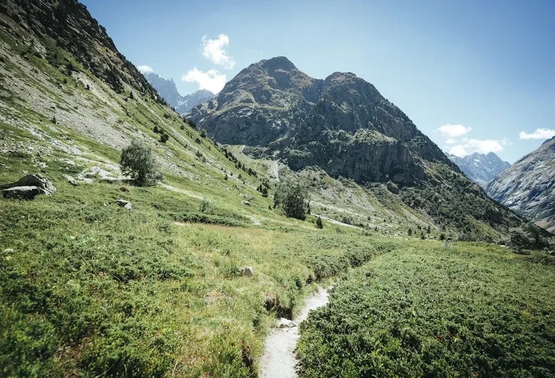
The Tour du Mont Lozère is more than just a hike; it's an exploration of a unique mountain environment. The Mont Lozère, standing at 1,699 metres, is a geological and ecological gem, a vast granite dome that rises above the surrounding landscape. The trail circumnavigates this summit, offering varied perspectives and experiences. You'll walk through dense beech and fir forests, their cool, shaded interiors a welcome respite on warmer days. As you ascend, the forests give way to open, windswept plateaus dotted with ancient stone shelters (known as 'burons') and vast expanses of heather and gorse. These high-altitude areas are home to a rich array of flora and fauna, including rare orchids, diverse birdlife, and the iconic Cévennes sheep.
The route is designed to showcase the diverse character of the Mont Lozère. It balances challenging ascents with gentle descents, passing through a mosaic of landscapes. You'll encounter clear mountain streams, perfect for refilling water bottles, and discover hidden springs that feed the region's rivers. The trail also offers glimpses into the human history of the area, with remnants of past agricultural practices and small, resilient communities. The moderate difficulty makes it accessible to most reasonably fit walkers, while the stunning scenery and peaceful atmosphere provide a deeply rewarding experience.
The best time to undertake this journey is from June to September, when the weather is generally stable and the mountain is at its most vibrant. Wildflowers carpet the meadows in early summer, and the autumn colours in September offer a different, equally beautiful spectacle. The trail is well-marked, but the remoteness and changeable mountain weather necessitate careful preparation and a good sense of direction.
History and Cultural Context
The Mont Lozère massif has a long and fascinating history, shaped by both natural forces and human endeavour. For centuries, this region has been a pastoral heartland, with shepherds and their flocks migrating to the high pastures during the summer months. The 'burons', the stone huts that dot the landscape, are testaments to this transhumance tradition. These simple structures provided shelter for shepherds and their families, and were often used to produce cheese, a staple of the local economy.
The Mont Lozère was also a significant area during periods of religious conflict in France. The Cévennes region was a stronghold of Protestantism, and the mountains offered refuge to Huguenots during times of persecution, particularly during the Wars of Religion and the Camisard rebellion in the early 18th century. The rugged terrain and the strong sense of community allowed these communities to maintain their faith and way of life.
Geologically, the Mont Lozère is part of the Massif Central, an ancient mountain range formed by volcanic activity and subsequent erosion. The granite bedrock has shaped the landscape, creating the distinctive rounded peaks, vast plateaus, and deep valleys that characterise the area. The region's isolation has helped preserve its unique cultural heritage and natural environment, making it a special place for those seeking an authentic mountain experience.
Seasonal Highlights and Weather Reality
The Tour du Mont Lozère is best enjoyed during the warmer months, from June to September. During this period, the weather is generally favourable for hiking, with long daylight hours and milder temperatures.
Spring (April-May): While the lower slopes may begin to show signs of life, the higher altitudes can still be cold, with lingering snow possible. Wildflowers start to bloom, but the weather can be unpredictable, with frequent rain showers. This is generally not the ideal time for the full circuit.
Summer (June-August): This is the peak season for the Tour du Mont Lozère. The days are long and warm, and the mountain is alive with colour. Wildflowers are abundant in the alpine meadows, and the forests are lush and green. Temperatures at higher elevations are pleasant, though can reach the high 20s Celsius in the valleys. Thunderstorms are possible in the afternoons, so starting early is advisable. Sandflies can be present, especially near water sources.
Autumn (September-October): September offers a beautiful transition with crisp air and stunning autumn foliage, particularly in the forested sections. The crowds thin out, and the weather can be very pleasant, though cooler. October can bring the first frosts and a higher chance of snow at higher elevations, making it more suitable for experienced hikers with appropriate gear.
Winter (November-March): The Mont Lozère is a winter destination for snow sports, but the hiking trails are often covered in snow and ice, making them impassable for standard hiking. This season requires winter mountaineering skills and equipment. The burons are typically closed, and access to trailheads can be difficult due to snow.
Weather Considerations: Mountain weather is notoriously changeable. Even in summer, temperatures can drop significantly at higher altitudes, and rain or fog can descend rapidly. It is essential to be prepared for all conditions, including cold, wind, and rain, regardless of the season.
Recommended Itinerary
3-Day Tour du Mont Lozère Itinerary
Day 1: Le Bleymard to Refuge du Mont Lozère
- Distance: 18 km
- Elevation gain: 700 m
- Time: 5–6 hours
- Start in the village of Le Bleymard (1,170 m)
- Ascend through beech forests, gradually gaining altitude
- Pass through charming hamlets and old agricultural areas
- The trail becomes more open as you approach the higher pastures
- Arrive at the Refuge du Mont Lozère (1,550 m), a well-equipped mountain refuge
- Enjoy panoramic views from the refuge's location
Day 2: Refuge du Mont Lozère to Mas de la Barque
- Distance: 20 km
- Elevation gain: 500 m, Elevation loss: 650 m
- Time: 6–7 hours
- Circumnavigate the summit of Mont Lozère, reaching its highest point (1,699 m)
- Walk across the vast, open granite plateau, passing numerous burons
- Experience the wild, windswept beauty of the high Cévennes
- Descend through mixed forests and open moorland
- Arrive at Mas de la Barque (1,330 m), a former forestry station now offering accommodation and facilities
- This day offers the most dramatic mountain scenery and a true sense of wilderness
Day 3: Mas de la Barque to Le Bleymard
- Distance: 16 km
- Elevation gain: 250 m, Elevation loss: 600 m
- Time: 4–5 hours
- Descend through varied terrain, including forests and meadows
- Pass by the source of the Tarn River (La Source du Tarn)
- Continue through picturesque countryside
- Arrive back in the village of Le Bleymard
- A more relaxed day, allowing for reflection on the journey
Alternative 4-Day Itinerary:
For a more leisurely pace, consider splitting Day 2 into two shorter days, perhaps staying at a gîte or a more remote accommodation option between the Refuge du Mont Lozère and Mas de la Barque. This allows for more time to explore side paths, enjoy the scenery, and visit points of interest.
Important Notes:
- Accommodation must be booked in advance, especially during peak season.
- Carry sufficient water, as reliable sources can be spaced out.
- Be prepared for changeable mountain weather.
- Trail marking is generally good, but a map and compass are recommended.
Planning and Bookings
Book Your Trip
Everything you need to plan your journey
Accommodation
Find places to stay near Mende
Flights
Search flights to Mende
Essential Preparation
The Tour du Mont Lozère is a well-established hiking route, but proper preparation is key to a successful and enjoyable experience. The closest major town is Mende, which serves as a good base for logistical arrangements. From Mende, you can access Le Bleymard, the primary trailhead, via local bus services or taxi. If travelling by car, the A75 motorway provides good access to Mende, and then the D20 road leads to Le Bleymard. Parking is available in Le Bleymard. It's advisable to book accommodation in advance, particularly for the mountain refuges and gîtes, as they have limited capacity. Familiarise yourself with the route using maps and guidebooks, and check weather forecasts regularly before and during your trip.
Trail Accommodation
Accommodation options along the Tour du Mont Lozère are varied, ranging from mountain refuges to village gîtes and even some basic shelters.
Refuge du Mont Lozère: Located at a high altitude (1,550 m), this refuge offers dormitory-style accommodation and meals. It's a popular stop and booking is essential, especially during summer. Facilities typically include bunk beds, shared bathrooms, and a dining area. It provides a true mountain experience.
Mas de la Barque: This former forestry station has been converted into accommodation, offering rooms and potentially dormitories. It's situated at a lower altitude than the refuge and provides a comfortable stopover. Booking is recommended.
Gîtes d'étape: Several villages along or near the route may offer 'gîtes d'étape', which are specifically designed for hikers and pilgrims. These typically provide simple rooms or dormitories and often serve meals. Examples might be found in villages like Villefort or other smaller hamlets.
Camping: Wild camping is generally not permitted in France, especially within national parks or protected areas. Designated campsites may be available in some villages, but are not typically found directly on the trail itself.
What's Provided: Accommodation (beds, often with blankets), and usually access to toilets and wash facilities. Refuges and gîtes often offer half-board (dinner and breakfast).
What's NOT Provided: Sleeping bags (though some refuges may rent them), towels, toiletries, and cooking equipment (unless you are self-catering in a gîte with a kitchen). Meals are usually an additional cost.
Seasonal Availability: Most refuges and gîtes operate from late spring (May/June) through early autumn (September/October). Outside these months, facilities may be closed or operate with reduced services.
Costs: Prices vary, but expect to pay approximately €30-€60 per person per night for half-board in a refuge or gîte. Dormitory beds will be cheaper than private rooms.
Required Gear
- Sturdy hiking boots: Waterproof, well broken-in, with good ankle support.
- Waterproof and windproof jacket: Essential for protection against sudden weather changes.
- Waterproof overtrousers: To keep dry during rain showers.
- Backpack: 30-45 litre capacity, comfortable with a hip belt.
- Sleeping bag: A 3-season bag is recommended, even in summer, as mountain nights can be cool.
- Head torch: With spare batteries, for use in refuges or if hiking in low light.
- Navigation tools: Detailed map of the area (e.g., IGN 1:25,000 scale), compass, and a GPS device or smartphone with offline maps.
- First-aid kit: Including blister treatment, pain relievers, antiseptic wipes, bandages, and any personal medications.
- Sun protection: High SPF sunscreen, sunglasses, and a wide-brimmed hat.
- Insect repellent: Especially for sandflies, which can be present in summer.
What to Bring
- Food and snacks: For lunches and energy boosts between meals. While some accommodation offers meals, it's wise to carry your own provisions.
- Water bottles or hydration reservoir: Capacity of at least 2 litres per person.
- Water purification tablets or filter: As a backup, though many streams are clear.
- Toiletries: Biodegradable soap, toothbrush, toothpaste, small towel.
- Personal items: Camera, phone, power bank, book, walking poles (optional but recommended).
- Cash: For accommodation, meals, and any small purchases in villages, as card facilities may not always be available.
- Lightweight clothing layers: Including thermal base layers, fleece or insulating mid-layers, and comfortable hiking trousers.
Permits
Generally, no specific permits are required to hike the Tour du Mont Lozère. The trails are part of the public footpath network in France. However, it is always advisable to check for any local regulations or temporary restrictions that may be in place, especially concerning camping or access to certain areas. Information can usually be found at local tourist offices or from the park authorities if the area falls within a protected zone.
Accommodation Bookings: While no permits are needed for the trail itself, booking accommodation in advance is highly recommended, particularly for the mountain refuges and gîtes d'étape. These facilities have limited capacity and can fill up quickly, especially during the peak hiking season (June to September). It is best to contact each accommodation provider directly to confirm availability and make reservations.
National Park Regulations: The Mont Lozère is part of the Parc National des Cévennes. While hiking is permitted, visitors are expected to adhere to the park's regulations, which typically include rules about waste disposal, respecting wildlife, and not disturbing the natural environment. Information on these regulations can usually be found at park visitor centres or on their official website.
Other Activities in the Area
The Mont Lozère region offers a variety of activities beyond hiking, allowing visitors to further explore its natural beauty and cultural heritage:
- Cycling: The mountain roads and forest tracks are popular with cyclists, offering challenging climbs and scenic routes.
- Horse Riding: Several stables in the region offer guided horse riding tours, providing a different perspective on the landscape.
- Wildlife Watching: The Cévennes are home to diverse wildlife, including deer, wild boar, and a rich variety of birdlife. Birdwatching and nature photography are popular pursuits.
- Visiting Local Villages: Explore charming villages like Le Bleymard, Villefort, and others, experiencing local culture, markets, and traditional cuisine.
- Discovering the Tarn River Source: A short detour from the main trail leads to the source of the Tarn River, a picturesque spot in the heart of the mountains.
- Exploring Burons: Many of the ancient shepherd's huts (burons) are still visible, offering a glimpse into the region's pastoral past. Some may be open for visitors to explore.
- Stargazing: The Mont Lozère, with its low light pollution, is an excellent location for stargazing. On clear nights, the sky is a breathtaking spectacle.
Safety and Conditions
Weather: Mountain weather can change rapidly. Be prepared for sun, rain, wind, and potentially cold temperatures, even in summer. Always check the weather forecast before setting out and be ready to adapt your plans. Hypothermia is a risk if you get wet and cold.
Navigation: While the Tour du Mont Lozère is generally well-marked, it is essential to carry a detailed map and compass and know how to use them. GPS devices or smartphone apps with offline maps are also highly recommended. Fog can descend quickly on the higher plateaus, reducing visibility to a few metres.
Water: Water sources are generally plentiful along the route, particularly from streams and springs. However, it is always advisable to treat water from natural sources using a filter or purification tablets, or to carry enough water for the entire day's hike. The Refuge du Mont Lozère and Mas de la Barque will have potable water.
Terrain: The trail includes ascents and descents, rocky sections, and open plateaus. Sturdy hiking boots are crucial for ankle support and grip. Be mindful of loose scree on steeper descents.
Wildlife: While encounters are rare, be aware of potential wildlife such as wild boar or vipers. Maintain a safe distance and do not attempt to feed any animals.
Emergency: In case of an emergency, carry a fully charged mobile phone. However, mobile signal can be unreliable in mountainous areas. Note the emergency numbers for France (112). Inform someone of your hiking plans and expected return time.
Physical Fitness: The trail is rated as moderate, but involves significant elevation gain and distance over consecutive days. Ensure you have a good level of fitness and are accustomed to multi-day hiking before undertaking this route.
Side Trips and Points of Interest
Mont Lozère Summit (Pic Finiels): The highest point of the Mont Lozère massif, reaching 1,699 metres. A short detour from the main trail on Day 2 allows you to reach the summit, offering spectacular 360-degree views across the Cévennes and beyond. On a clear day, you can see as far as the Alps.
Source of the Tarn River (La Source du Tarn): Located on Day 3 of the itinerary, this is the official source of the Tarn River, one of France's most beautiful rivers. It's a tranquil spot where the river begins its journey.
Burons: Scattered across the high plateaus, these ancient stone shepherd's huts are a distinctive feature of the Mont Lozère landscape. Many are in ruins, but some are remarkably well-preserved, offering a tangible link to the region's pastoral heritage. They provide excellent opportunities for photography and reflection.
Panoramic Viewpoints: Numerous points along the trail offer breathtaking vistas. The open plateaus on Day 2 are particularly rich in viewpoints, allowing you to appreciate the vastness and rugged beauty of the Cévennes.
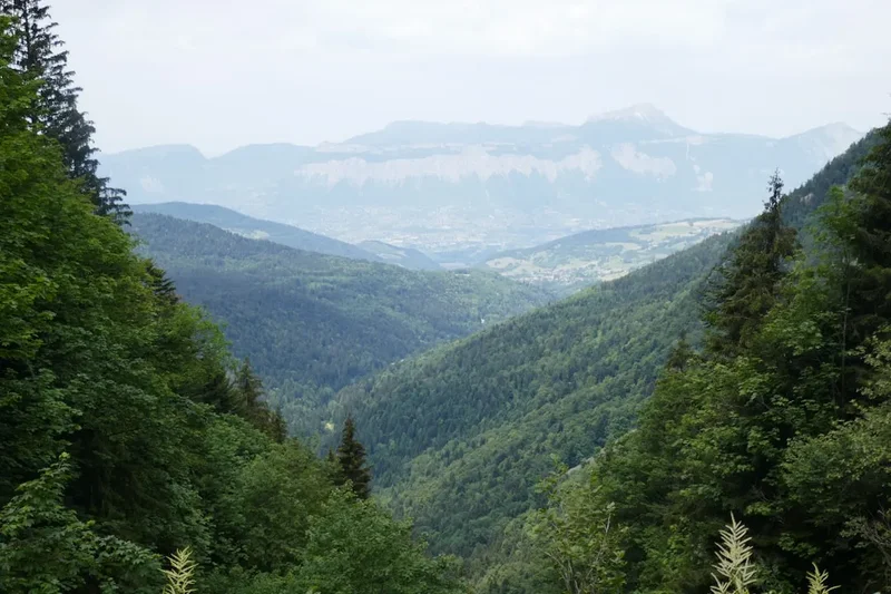
Forest Sections: The trail passes through beautiful beech and fir forests, especially on the ascents and descents. These offer a different atmosphere, with cool shade, dappled sunlight, and the scent of pine.
Leave No Trace

The Mont Lozère is a precious natural environment, and it is crucial for all visitors to practice Leave No Trace principles to preserve its beauty and ecological integrity for future generations.
- Plan Ahead and Prepare: Familiarise yourself with the trail, weather conditions, and any local regulations. Book accommodation in advance.
- Travel and Camp on Durable Surfaces: Stick to marked trails to avoid damaging fragile vegetation. Avoid creating new paths. If camping is permitted in designated areas, use established sites.
- Dispose of Waste Properly: Pack out everything you pack in, including all food scraps, wrappers, and toilet paper. Use designated toilets where available. If no toilets are available, dig a cathole at least 60 metres away from water sources, trails, and campsites.
- Leave What You Find: Do not remove or disturb natural objects such as rocks, plants, or historical artefacts.
- Minimise Campfire Impacts: Campfires are generally discouraged or prohibited in many natural areas. If permitted and necessary, use existing fire rings and keep fires small. Ensure fires are completely extinguished.
- Respect Wildlife: Observe wildlife from a distance. Never feed animals, as it can harm their health and alter their natural behaviour.
- Be Considerate of Other Visitors: Respect the peace and tranquility of the natural environment. Avoid loud noises and be courteous to other hikers.
By adhering to these principles, you help ensure that the Mont Lozère remains a wild and beautiful place for everyone to enjoy.