France/Italy/Switzerland — Chamonix
Circumnavigate Western Europe's highest peak on the Tour du Mont Blanc (TMB), a 170km demanding trek through France, Italy, and Switzerland. This iconic route traverses seven alpine valleys, crossing high mountain passes and past shimmering glaciers. Expect rugged terrain, breathtaking panoramas, and a truly unforgettable high-altitude adventure over 10-12 days.
Distance: 170.0 km
Elevation Gain: 10000 m
Difficulty: Challenging
Duration: 10-12 days
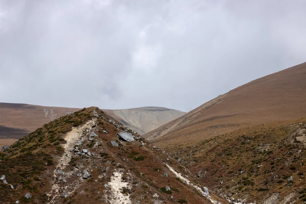
The Tour du Mont Blanc, or TMB, is widely considered one of the most iconic long-distance trekking routes in the world. Encircling the magnificent Mont Blanc massif, the highest peak in Western Europe, this 170-kilometre journey traverses three different countries: France, Italy, and Switzerland. It is a trail of staggering beauty, taking hikers through seven distinct alpine valleys, over high mountain passes (cols), and past shimmering glaciers that spill down from the granite spires of the massif. Unlike many wilderness treks that isolate the walker from civilisation, the TMB offers a unique blend of rugged natural splendour and rich European mountain culture. Hikers transition from the lush, cow-dotted pastures of the French Savoie to the dramatic, steep-sided valleys of the Italian Aosta, and finally to the pristine, chocolate-box villages of the Swiss Valais.
The route is physically demanding, involving approximately 10,000 metres of cumulative elevation gain and loss—roughly equivalent to climbing Mount Everest from sea level and back again. However, the reward is a constantly shifting panorama of the "King of the Alps." Whether you are gazing at the jagged Aiguilles of Chamonix, the immense Brenva face on the Italian side, or the gentle meadows of the Val Ferret, the scale of the landscape is consistently humbling. With a well-developed network of mountain refuges (refuges, rifugi, or cabanes) providing food and shelter, the TMB allows walkers to experience the high mountains without the need to carry heavy camping gear, making it an accessible yet challenging adventure for fit hikers from around the globe.
The Tour du Mont Blanc is more than just a hike; it is a rite of passage for trekkers. The standard route is traditionally walked in an anti-clockwise direction, starting in the Chamonix Valley at Les Houches, though it can be started at any point along the loop and walked in either direction. The anti-clockwise direction is favoured by many as it offers what some consider to be the most dramatic reveals of the Mont Blanc summit, particularly as you cross from Italy into Switzerland and back into France.
The landscape of the TMB is defined by its diversity. The French section is characterised by wide, green valleys and the dramatic ascent over the Col du Bonhomme. The Italian side, often considered the most spectacular, offers a rugged, "Himalayan" feel with the vertical granite walls of the south face of Mont Blanc looming directly over the trail. The Swiss section provides a gentler, more pastoral experience, with well-manicured trails and charming villages like Champex-Lac, before the final high-altitude push back into the French Aiguilles Rouges. Throughout the journey, the presence of the glaciers—such as the Bionnassay, Miage, and Trient—serves as a constant reminder of the geological forces that have carved these mountains over millennia.
One of the most appealing aspects of the TMB is the flexibility it offers. While the "classic" route is well-defined, there are numerous "variants" that allow hikers to choose between easier valley paths or more strenuous, high-altitude ridges. For example, the crossing from Switzerland to France can be done via the relatively straightforward Col de Balme or the much more technical and steep Fenêtre d'Arpette. This allows hikers to tailor the difficulty of the trek to their fitness levels and the prevailing weather conditions. Despite its popularity, the sheer scale of the massif means that once you are away from the main trailheads, a sense of mountain solitude is still very much achievable, especially in the early morning or late afternoon.
Logistically, the TMB is supported by an exceptional infrastructure. The mountain refuges are a highlight of the experience, offering "half-board" accommodation that includes a multi-course communal dinner and breakfast. This social aspect of the trek, where hikers from dozens of different countries share stories over a bottle of local wine or a bowl of hearty soup, is an integral part of the TMB's charm. However, this popularity means that planning is essential; the trail has seen a significant surge in interest in recent years, and securing a bed in the most popular refuges now requires booking many months in advance.
The history of the Tour du Mont Blanc is inextricably linked to the birth of modern mountaineering and alpine tourism. While local hunters, crystal seekers, and shepherds had navigated these passes for centuries, the concept of "touring" the mountain for pleasure began in the 18th century. The first recorded circumnavigation of the massif was completed in 1767 by Horace-Bénédict de Saussure, a Genevese aristocrat and scientist. Saussure was obsessed with Mont Blanc and had offered a prize for the first person to find a route to its summit. His journey around the base was a scientific expedition intended to study the geology and botany of the region, but it effectively laid the groundwork for the trekking route we know today.
In the 19th century, the "Grand Tour" of the Alps became a popular pursuit for wealthy Europeans, particularly the British. Chamonix transformed from a remote farming hamlet into a bustling tourist hub. The development of the trail network was further accelerated by the creation of the first mountain refuges by the Club Alpin Français (CAF) and its Italian and Swiss counterparts. These early shelters were basic stone huts designed to provide safety for climbers, but they eventually evolved into the comfortable hostels that serve trekkers today. The TMB as a formalised, waymarked route was established in the mid-20th century, and it has since become the benchmark against which all other European long-distance trails are measured.
Culturally, the TMB is a fascinating study in alpine borders. For much of history, the people living in these high valleys had more in common with their neighbours across the mountain passes than with the distant governments in Paris, Turin, or Bern. The local dialects, traditional architecture (such as the stone-roofed chalets of the Aosta Valley), and culinary traditions (centred on cheese, dried meats, and polenta) reflect a shared mountain heritage. Walking the TMB allows you to witness these subtle shifts in culture—from the French obsession with Beaufort cheese to the Italian love for strong espresso and the Swiss precision in trail maintenance. The mountains do not just divide these nations; they provide a common ground that has shaped the identity of the people who live in their shadow.
Want more background? Read extended notes on history and cultural context → Learn more
The window for hiking the Tour du Mont Blanc is relatively short, dictated by the presence of snow on the high passes. The official season typically runs from mid-June to mid-September, when the mountain refuges are open and the trails are generally clear of dangerous snow patches.
Late June to Early July: This is a beautiful time to hike, as the alpine wildflowers are in full bloom and the mountains are at their greenest. However, this period often features "névé" (lingering patches of old winter snow) on the higher cols, such as the Col du Bonhomme and the Grand Col Ferret. These patches can be slippery and may require trekking poles or even micro-spikes for safety. The weather is often variable, with a mix of bright sunshine and afternoon thunderstorms.
July and August: This is the peak season. The weather is generally more stable and the trails are completely clear of snow. However, this is also the busiest time on the trail. The refuges are often at full capacity, and the popular sections near Chamonix and Courmayeur can feel crowded. In late August, the region hosts the Ultra-Trail du Mont-Blanc (UTMB), one of the world's most famous trail running races. During this week, thousands of runners descend on the trail, and accommodation is almost impossible to find unless booked a year in advance.
September: Many experienced hikers consider September to be the best month for the TMB. The crowds thin out significantly, the air is crisp and clear, and the autumn colours begin to touch the larch forests. The weather is often more stable than in mid-summer, though the days are shorter and the nights at high altitude can be quite cold. Most refuges begin to close by the third week of September, so careful planning is required for late-season treks.
Winter and Spring: Outside of the summer season, the TMB is an alpine environment that requires mountaineering skills. The passes are buried under several metres of snow, and avalanche risk is high. The route is only attempted by experienced ski tourers or snowshoers during this time, and most of the standard trekking infrastructure is closed.
Day 1: Les Houches to Les Contamines-Montjoie
Day 2: Les Contamines to Les Chapieux
Day 3: Les Chapieux to Rifugio Elisabetta
Day 4: Rifugio Elisabetta to Courmayeur
Day 5: Courmayeur to Rifugio Bonatti
Day 6: Rifugio Bonatti to La Fouly
Day 7: La Fouly to Champex-Lac
Day 8: Champex-Lac to Trient
Day 9: Trient to Argentière
Day 10: Argentière to La Flégère
Day 11: La Flégère to Les Houches
Important Notes:
The Tour du Mont Blanc is a serious undertaking that requires significant physical and logistical preparation. Fitness is the most critical factor; you should be comfortable walking 15–20 kilometres a day with 1,000 metres of elevation gain for multiple consecutive days. Training should involve hiking with a weighted pack (8–10 kg) and focusing on leg strength and cardiovascular endurance. If you are not used to steep descents, your knees will feel the strain, so incorporating downhill training is essential.
Logistically, the TMB requires coordination between three countries. Chamonix is the primary hub, easily accessible from Geneva Airport (GVA) via mountain shuttles (approx. 1 hour 15 minutes). Most hikers base themselves in Chamonix or Les Houches for a night before and after the trek. Booking your accommodation is the most time-consuming part of planning. The "Autour du Mont Blanc" website is the official portal for booking most French, Italian, and Swiss refuges, but some private gîtes and hotels must be contacted directly. It is highly recommended to start booking in January or February for a summer trek.
The TMB offers a variety of accommodation options, ranging from basic mountain refuges to comfortable valley hotels. Most trekkers opt for a mix of these to balance the "authentic" mountain experience with occasional comfort.
Mountain Refuges (Refuges/Rifugi/Cabanes): These are the heart of the TMB. They typically offer dormitory-style sleeping arrangements (ranging from 4 to 40 people per room).
Valley Gîtes and Hotels: In towns like Les Contamines, Courmayeur, and Champex-Lac, you can find private hotels or "gîtes d'étape" (hikers' hostels). These offer more privacy and often better facilities, including WiFi and laundry services. Prices in towns are generally higher than in the mountains.
Camping: Wild camping is strictly regulated. In France, "bivouacking" (setting up a tent at sunset and taking it down at sunrise) is generally allowed above 2,500 metres or near certain refuges, but it is forbidden in many parts of the nature reserves. In Italy and Switzerland, wild camping is largely prohibited. There are designated campsites in the valleys, but these require carrying a full tent, stove, and sleeping gear, which significantly increases the difficulty of the trek.
One of the great advantages of the Tour du Mont Blanc is that there is no official "permit" required to hike the trail. Unlike the John Muir Trail in the USA or the Milford Track in New Zealand, you do not need to win a lottery or pay a specific trail fee to access the route. The trail is public and free to use.
However, the "permit" in practice is your accommodation booking. Because wild camping is restricted and the mountain environment is fragile, your ability to complete the trek is entirely dependent on securing a place to sleep. During the peak months of July and August, the trail is effectively "at capacity" because every bed in every refuge is full. If you show up at a refuge without a booking, you may be turned away, which can be dangerous in a mountain environment with no other nearby shelter.
Booking Strategy:
Nature Reserve Regulations: While no permit is needed to walk, you must adhere to the rules of the various Nature Reserves you pass through (such as the Réserve Naturelle des Contamines-Montjoie and the Aiguilles Rouges). These rules include staying on marked paths, not picking flowers, and strict prohibitions on dogs in certain areas.

Detailed route notes, maps, logistics & tips for the Tour Du Mont Blanc (PDF).

Precisely traced GPX for the Tour Du Mont Blanc, ready for your GPS or favourite mapping app.
The Chamonix Valley and the surrounding regions of Italy and Switzerland offer a wealth of activities for those looking to extend their trip or for non-hiking partners:
Mountain Weather: The weather in the Alps can change with terrifying speed. A bright, sunny morning can transform into a violent thunderstorm with hail and near-zero visibility by mid-afternoon. Always check the local forecast (Météo-France, MeteoSwiss, or Meteo vda for Italy) before setting out. If a storm is predicted, aim to be off the high passes and at your destination by early afternoon.
Terrain Hazards: The TMB is a well-maintained hiking trail, but it is not without risks.
Navigation: The trail is very well-marked, but in thick fog, it is easy to lose the path. Always carry a physical map and a compass, and know how to use them. Do not rely solely on your phone, as batteries die quickly in the cold and GPS can be unreliable in deep valleys.
Health: Dehydration and heat exhaustion are common in mid-summer. Drink plenty of water and use electrolyte replacements. Blisters are the most common reason for people failing to finish the TMB; treat "hot spots" immediately with tape or Compeed before they become full-blown blisters.
Emergency Services: The European emergency number is 112. Mountain rescue in the Alps is highly professional but can be extremely expensive. Ensure your travel insurance specifically covers "mountain search and rescue" and "helicopter evacuation" up to 3,000 metres.
Lac Blanc (France): Located in the Aiguilles Rouges, this is perhaps the most famous viewpoint on the TMB. The lake perfectly reflects the Mont Blanc massif on a calm day. While it is part of the standard Day 10 itinerary for many, it is technically a slight detour from the main TMB valley path and is absolutely worth the extra effort.
Fenêtre d'Arpette (Switzerland): This is the highest point on the TMB (2,665 m) and is a challenging variant to the Bovines route between Champex and Trient. It involves a steep, boulder-strewn ascent and descent, but it offers an incredible, close-up view of the Trient Glacier. Only attempt this in clear, dry weather.
Col des Fours (France): A variant on Day 2 that bypasses the descent to Les Chapieux and takes you over a higher, more rugged pass. From the col, a short 15-minute scramble leads to the Tête Nord des Fours, offering a 360-degree panorama that includes the remote Beaufortain mountains.
The "Ladders" of the Aiguilles Rouges: On the section between Argentière and La Flégère, there is a series of fixed metal ladders and handrails built into the rock face. It is not a via ferrata, but it provides a thrilling bit of "scrambling" for those who aren't afraid of heights. There is a forest-based path that bypasses this for those who prefer to keep their feet on the ground.
Notre Dame de la Gorge: A beautiful Baroque chapel at the end of the Les Contamines valley. It marks the start of the Roman road that leads up to the Col du Bonhomme. It is a peaceful place to pause before the long climb begins.
The Tour du Mont Blanc passes through some of the most environmentally sensitive areas in Europe. With over 20,000 people walking the trail every year, the cumulative impact can be devastating if hikers do not follow Leave No Trace principles.
Protecting the Alpine Environment:
By following these guidelines, you help ensure that the TMB remains a pristine and beautiful experience for the generations of hikers who will follow in your footsteps.