Tour des Glaciers de la Vanoise - Alpine Majesty
The Tour des Glaciers de la Vanoise is a spectacular multi-day trek encircling the Vanoise National Park in the French Alps. This challenging route offers an immersive experience of high-alpine landscapes, from vast glacial cirques and rugged peaks to emerald alpine meadows dotted with wildflowers. It is a journey through a protected natural reserve, renowned for its rich biodiversity, including ibex, chamois, and a remarkable array of alpine flora. The trail is a true test of endurance and navigation, rewarding walkers with breathtaking panoramas and a profound sense of wilderness.
- Distance: 72.0 km
- Duration: 4-6 days
- Season: Mid-June to September
- Huts: Numerous mountain refuges (refuges) and some bivouac shelters
- Highest point: Col de la Vanoise (2,517 m)
- Difficulty: Challenging
- Base Town: Chambéry, with Pralognan-la-Vanoise as a key access point
- Direction: Can be walked in either direction, though a counter-clockwise route is common
Overview
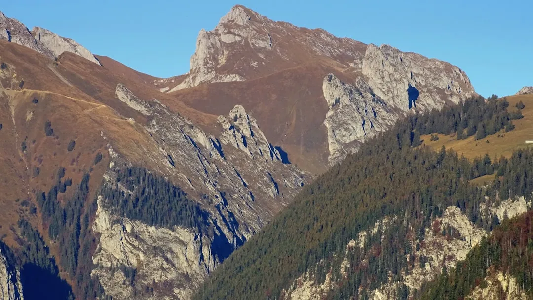
The Tour des Glaciers de la Vanoise is a quintessential alpine circuit, designed for experienced hikers seeking dramatic mountain scenery and a genuine wilderness experience. Unlike more manicured trails, this route traverses high mountain passes, rocky terrain, and sometimes snow-covered sections, demanding a good level of fitness and sure-footedness. The Vanoise National Park, established in 1963, is France's first national park and a sanctuary for wildlife and alpine ecosystems. The park's commitment to conservation means that the landscapes remain largely unspoiled, offering walkers a chance to witness nature in its rawest form.
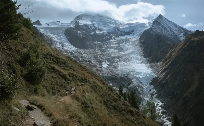
The trail is characterised by its varied terrain. You will ascend through fragrant pine forests, cross open alpine pastures bursting with colour in summer, and navigate scree slopes and rocky paths. The highlight for many is the proximity to glaciers, which carve out the dramatic U-shaped valleys and leave behind moraines and glacial lakes. The views are consistently awe-inspiring, with jagged peaks like the Grande Casse (3,855 m) dominating the skyline. The network of mountain refuges provides essential shelter and sustenance, allowing for a multi-day exploration of this magnificent alpine region.
The Vanoise is a paradise for nature lovers. Keep an eye out for the iconic ibex, often seen grazing on steep slopes, and the agile chamois. Birdlife is also abundant, with species like the golden eagle and ptarmigan inhabiting the higher altitudes. The flora is equally impressive, with a dazzling display of wildflowers in the summer months, including gentians, edelweiss, and alpine roses. The Tour des Glaciers de la Vanoise is more than just a hike; it's an expedition into the heart of the French Alps, offering a profound connection with nature and a sense of accomplishment that comes from conquering challenging mountain terrain.
History and Cultural Context
The Vanoise region has a long history of human interaction, primarily driven by pastoralism and mining. For centuries, shepherds have guided their flocks to the high alpine pastures (alpages) during the summer months, a tradition that continues today. The network of trails that now forms the Tour des Glaciers de la Vanoise often follows ancient routes used by these shepherds and, before them, by local communities for trade and access to resources.
The Vanoise was also a significant area for mining, particularly for copper and lead, from the Middle Ages until the early 20th century. Evidence of this industrial past can still be found in some areas, with old mine shafts and remnants of mining infrastructure. However, the region's true value was recognised for its natural beauty and unique wildlife, leading to the establishment of the Parc National de la Vanoise in 1963. This was France's first national park, created to protect the exceptional alpine environment and its fauna, particularly the ibex, which had been hunted to near extinction and was reintroduced to the Vanoise in the mid-20th century.
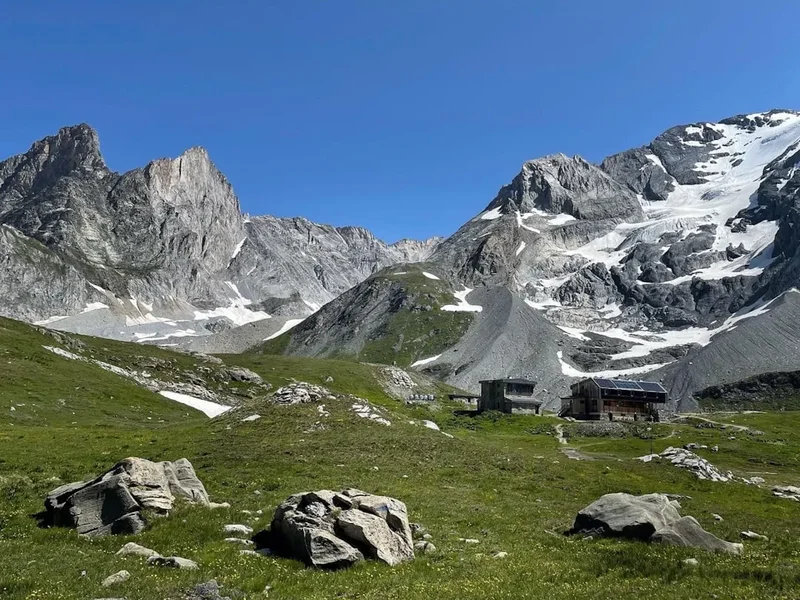
The mountain refuges that dot the landscape are themselves part of the region's history. Many were built in the late 19th and early 20th centuries by mountaineering clubs, such as the Club Alpin Français (CAF), to facilitate access to the high peaks and glaciers for climbers and hikers. These refuges have evolved over time, offering increasingly comfortable accommodation while maintaining their essential role as shelters in this remote and often harsh environment. The Tour des Glaciers de la Vanoise thus traverses a landscape rich in both natural and human history, a testament to the enduring relationship between people and the high mountains.
Seasonal Highlights and Weather Reality
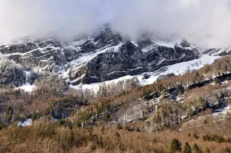
The Vanoise National Park experiences a distinct alpine climate, with short summers and long, harsh winters. The best time to undertake the Tour des Glaciers de la Vanoise is during the summer months, from mid-June to mid-September. During this period, the snow generally melts from the higher passes, and the mountain refuges are open and staffed.
Mid-June to July: This is the period of peak wildflower bloom. The alpine meadows are carpeted with vibrant colours, and the air is filled with the scent of mountain flora. The days are long, offering ample daylight for hiking. However, higher passes may still hold significant snow, and some routes might be challenging or require snow gear. Waterfalls are at their most powerful due to snowmelt.
August: This is the most popular month for hiking in the Vanoise. The weather is generally stable, though afternoon thunderstorms are common. The ibex and chamois are often more visible, and the landscapes are at their most accessible. Refuges can be very busy, so booking in advance is essential.
September: The autumn colours begin to appear in the lower valleys, and the crowds thin out. The weather can be crisp and clear, offering excellent visibility. However, the days are shorter, and the risk of early snow on the higher passes increases as the month progresses. Some refuges may begin to close towards the end of September.
Weather: Alpine weather is notoriously unpredictable. Even in summer, conditions can change rapidly. Expect a wide range of temperatures, from warm days in the valleys to near-freezing temperatures at higher altitudes, especially at night. Rain, hail, and even snow can occur at any time. It is crucial to be prepared for all conditions.
Recommended Itinerary
4-Day Challenging Itinerary (Fast-Paced)
Day 1: Pralognan-la-Vanoise to Refuge du Col de la Vanoise
- Distance: 12 km
- Elevation gain: 1,000 m
- Time: 4–5 hours
- Start in Pralognan-la-Vanoise (1,410 m)
- Ascend through forests and then open pastures towards the Col de la Vanoise
- Pass by the picturesque Lac des Vaches with its iconic reflection of the Grande Casse
- Arrive at Refuge du Col de la Vanoise (2,517 m)
- This day is a significant ascent, acclimatising you to the altitude and the Vanoise's grandeur.
Day 2: Refuge du Col de la Vanoise to Refuge de la Dent Parrachée
- Distance: 15 km
- Elevation gain: 700 m, Elevation loss: 600 m
- Time: 5–6 hours
- Descend from the Col de la Vanoise
- Traverse high alpine terrain, potentially crossing snowfields early in the season
- Pass through the stunning Vallon de la Rosière
- Arrive at Refuge de la Dent Parrachée (2,200 m)
- A day of high mountain walking with varied terrain and expansive views.
Day 3: Refuge de la Dent Parrachée to Refuge de la Femma
- Distance: 18 km
- Elevation gain: 800 m, Elevation loss: 900 m
- Time: 6–7 hours
- Ascend towards the Col de la Souffrance
- Descend into the remote and wild Vallon de la Femma
- This section offers a true sense of isolation and rugged beauty
- Arrive at Refuge de la Femma (2,000 m)
- A challenging day involving significant ascents and descents through remote valleys.
Day 4: Refuge de la Femma to Pralognan-la-Vanoise
- Distance: 27 km
- Elevation gain: 600 m, Elevation loss: 1,300 m
- Time: 8–9 hours
- A long final day, descending back towards Pralognan
- Traverse through varied landscapes, including forests and alpine meadows
- The descent can be demanding on the knees
- Arrive back in Pralognan-la-Vanoise (1,410 m)
- A demanding but rewarding final day, completing the circuit.
5-Day Moderate Itinerary (More Relaxed Pace)
Day 1: Pralognan-la-Vanoise to Refuge du Col de la Vanoise (as above)
Day 2: Refuge du Col de la Vanoise to Refuge de l'Arpont
- Distance: 14 km
- Elevation gain: 400 m, Elevation loss: 500 m
- Time: 4–5 hours
- A more moderate day, allowing more time to enjoy the scenery
- Arrive at Refuge de l'Arpont (2,309 m)
Day 3: Refuge de l'Arpont to Refuge de la Dent Parrachée
- Distance: 12 km
- Elevation gain: 600 m, Elevation loss: 500 m
- Time: 4–5 hours
- Another manageable day, focusing on the high alpine environment
- Arrive at Refuge de la Dent Parrachée (2,200 m)
Day 4: Refuge de la Dent Parrachée to Refuge de la Femma
- Distance: 18 km
- Elevation gain: 800 m, Elevation loss: 900 m
- Time: 6–7 hours
- As per the 4-day itinerary, a challenging day through remote valleys.
- Arrive at Refuge de la Femma (2,000 m)
Day 5: Refuge de la Femma to Pralognan-la-Vanoise
- Distance: 27 km
- Elevation gain: 600 m, Elevation loss: 1,300 m
- Time: 8–9 hours
- As per the 4-day itinerary, a long final day.
- Arrive back in Pralognan-la-Vanoise (1,410 m)
Important Notes:
- This itinerary is a suggestion; adjust based on your fitness, weather, and preferences.
- Refuge bookings are mandatory, especially during peak season (July-August).
- Carry sufficient water or a purification method, as water sources can be scarce at high altitudes.
- Be prepared for rapid weather changes.
- Check snow conditions on passes, especially in early summer.
Planning and Bookings
Book Your Trip
Everything you need to plan your journey
Accommodation
Find places to stay near Chambéry
Flights
Search flights to Chambéry
Essential Preparation
The Tour des Glaciers de la Vanoise is a demanding trek that requires careful planning and preparation. Your fitness level is paramount; you should be comfortable hiking for 6-9 hours a day with a substantial backpack, carrying significant elevation gains and losses over consecutive days. Familiarity with mountain terrain, navigation using a map and compass (or GPS device), and experience with alpine weather are highly recommended.
The primary logistical hub for this trek is Chambéry, the closest major city. From Chambéry, you can take a train or bus to Pralognan-la-Vanoise, which serves as the main trailhead and a charming alpine village with amenities like accommodation, restaurants, and gear shops. Driving is also an option, with parking available in Pralognan. It is advisable to spend at least one night in Pralognan before starting your trek to finalise preparations and acclimatise slightly.
Booking accommodation in the mountain refuges is crucial, particularly during the peak season (July and August). Many refuges are popular with both hikers and climbers and can fill up weeks or even months in advance. It is also wise to check the opening and closing dates of the refuges, as they are typically only staffed and fully operational from mid-June to mid-September.
Trail Accommodation
The Tour des Glaciers de la Vanoise is serviced by a network of mountain refuges (refuges de montagne) and some bivouac shelters. These provide essential accommodation, meals, and a place to rest. Booking in advance is highly recommended, and often mandatory.
Refuge Facilities:
- Dormitory-style sleeping quarters with bunk beds and blankets/duvets (a sleeping bag liner is usually required).
- Communal dining areas.
- Evening meals and breakfast are typically provided (half-board). Packed lunches can often be ordered for the next day.
- Access to toilets and washbasins (showers may be available but are often cold and limited).
- Some refuges have limited charging facilities for electronic devices, but this should not be relied upon.
What's NOT Provided:
- Personal sleeping bags (a liner is usually sufficient, but check with individual refuges).
- Towels.
- Toiletries.
- Cooking equipment or food for self-catering (unless specified as a self-catering refuge).
Seasonal Availability: Most refuges are open from mid-June to mid-September. Some higher or more remote refuges may have shorter seasons or operate on a caretaker basis outside these times, offering only basic shelter. Always check the specific opening dates for each refuge on your planned route.
Costs: Prices vary, but expect to pay approximately €40-€60 per person per night for half-board (dinner, breakfast, and accommodation). Non-members of the Club Alpin Français (CAF) may pay a slightly higher rate.
Bivouac Shelters: Some areas may have basic bivouac shelters for emergency use or for those undertaking more minimalist trips. These offer minimal protection and are not a substitute for booked refuge accommodation.
Required Gear
- Sturdy hiking boots: Waterproof, broken-in, with good ankle support. Essential for rocky and uneven terrain.
- Backpack: 40-60 litre capacity, with a rain cover. Ensure it fits comfortably and distributes weight well.
- Waterproof jacket and trousers: Breathable and fully waterproof (e.g., Gore-Tex). Essential for unpredictable alpine weather.
- Warm layers: Fleece jacket or down vest, thermal base layers (merino wool or synthetic).
- Hat and gloves: Even in summer, temperatures can drop significantly at altitude.
- Sleeping bag liner: Most refuges require this for hygiene.
- Head torch: With spare batteries, for use in dormitories and for early morning starts.
- Navigation tools: Detailed topographic maps of the Vanoise region, compass, and a GPS device or smartphone with offline maps.
- First-aid kit: Including blister treatment, pain relievers, antiseptic wipes, bandages, and any personal medications.
- Sun protection: High SPF sunscreen, sunglasses, and a wide-brimmed hat. The sun is intense at altitude.
- Trekking poles: Highly recommended for stability on ascents and descents, and to reduce strain on knees.
What to Bring
- Food: While refuges offer meals, carry high-energy snacks like nuts, dried fruit, energy bars, and chocolate for lunches and in-between meals.
- Water bottles or hydration reservoir: Capacity of at least 2 litres per person.
- Water purification method: Tablets or a filter, as not all water sources are guaranteed safe.
- Toiletries: Biodegradable soap, toothbrush, toothpaste, small towel, hand sanitiser.
- Personal items: Camera, power bank for electronics, book or journal.
- Cash: For refuge payments (some may not accept cards), and for small purchases in villages. Euros are the currency.
- Identification and travel documents: Passport, insurance details.
- Small backpack or daypack: For shorter excursions from refuges or for carrying essentials during the day.
Permits
The Tour des Glaciers de la Vanoise traverses the Vanoise National Park. While there are no specific "permits" required to hike the trails themselves, visitors must adhere to the park's regulations. These regulations are in place to protect the fragile alpine environment and its wildlife.
Key Park Regulations:
- Respect Wildlife: Do not feed or disturb animals. Maintain a safe distance.
- Stay on Marked Trails: To prevent erosion and protect vegetation, always follow designated paths.
- No Camping: Wild camping is generally prohibited within the Vanoise National Park, especially in sensitive areas. Accommodation must be in designated refuges or authorised campsites.
- Waste Disposal: Pack out all litter. Leave no trace of your visit.
- Fires: Open fires are strictly forbidden.
- Noise: Keep noise levels to a minimum to avoid disturbing wildlife and other visitors.
Refuge Bookings: The most critical "booking" requirement is for accommodation in the mountain refuges. These are managed by various organisations, most commonly the Club Alpin Français (CAF) or independent operators. It is essential to book your nights in refuges well in advance, especially during the peak summer season (July and August). Websites for individual refuges or the CAF website are the best places to secure these bookings.
Fees: There are no entry fees for the Vanoise National Park itself. However, you will incur costs for accommodation in the refuges, and potentially for transport to and from the park.
Other Activities in the Area
The Vanoise region offers a wealth of activities beyond the Tour des Glaciers, catering to various interests:
- Mountaineering and Climbing: The Vanoise is a premier destination for mountaineering, with numerous peaks offering routes for all levels, from beginner scrambles to challenging ascents of 3,000m+ peaks like the Grande Casse.
- Via Ferrata: Several well-equipped via ferrata routes are available in the area, providing a thrilling way to experience cliff faces and high-altitude views.
- Mountain Biking: Designated trails and routes cater to mountain bikers, offering a different perspective on the alpine landscape.
- Paragliding: For the adventurous, tandem paragliding flights offer unparalleled aerial views of the Vanoise massif.
- Skiing and Snowboarding: During winter, the Vanoise is a world-renowned ski destination, with resorts like Val Thorens, Les Menuires, and Courchevel offering extensive slopes.
- Relaxation in Pralognan-la-Vanoise: The village itself offers a charming alpine atmosphere, with opportunities for leisurely walks, enjoying local cuisine, and visiting local craft shops.
- Glacier Exploration: Guided tours to some of the park's accessible glaciers can provide a unique insight into these dynamic ice formations.
Safety and Conditions
Pre-Trip Checks:
- Weather Forecast: Always check the latest mountain weather forecast for the Vanoise region before and during your trek. Websites like Météo-France provide detailed alpine forecasts.
- Trail Conditions: Inquire at local tourist offices or refuges about current trail conditions, especially regarding snow cover on passes and any potential hazards.
- Refuge Status: Confirm that all refuges on your planned route are open and staffed.
- Emergency Contacts: Save local emergency numbers (SAMU: 15, Pompiers: 18, European emergency number: 112) and the numbers for the refuges you will be staying at.
On the Trail:
- Altitude Sickness: Be aware of the symptoms of altitude sickness (headache, nausea, dizziness). Ascend gradually, stay hydrated, and avoid overexertion. If symptoms worsen, descend immediately.
- Navigation: Do not rely solely on electronic devices. Carry a physical map and compass and know how to use them. Trails can be poorly marked in places, especially in fog or snow.
- Weather Changes: Be prepared for rapid weather shifts. Carry all your layers and waterproofs, even on seemingly clear days. Seek shelter immediately if a thunderstorm approaches.
- Terrain: The terrain can be steep, rocky, and exposed. Wear appropriate footwear and use trekking poles for stability. Be cautious on scree slopes and near steep drop-offs.
- Water Sources: While many streams are clear, it is advisable to treat all water from natural sources to avoid gastrointestinal issues.
- Wildlife Encounters: Maintain a respectful distance from all wildlife. Do not attempt to feed or approach animals like ibex or chamois.
- Communication: Mobile phone reception is unreliable in the mountains. Consider carrying a personal locator beacon (PLB) or satellite messenger for emergencies.
Refuge Safety: Follow the instructions of refuge wardens. Be mindful of noise levels, especially at night, to allow others to rest. Ensure you have your sleeping bag liner and any other required items.
Insurance: Ensure you have adequate travel insurance that covers mountain activities, including potential search and rescue operations.
Side Trips and Points of Interest
Lac des Vaches: Located near the Refuge du Col de la Vanoise, this iconic lake is famous for its crystal-clear water and the stunning reflection of the Grande Casse massif. It's a perfect spot for photography and a moment of reflection.
Grande Casse: The highest peak in the Vanoise massif (3,855 m). While summiting requires advanced mountaineering skills and a guide, the views of the glacier-covered massif from the surrounding trails are spectacular.
Glacier de la Vanoise: The trail passes close to the remnants of this once-vast glacier. Observing the glacial features, moraines, and meltwater streams offers a powerful lesson in the forces of nature and the impact of climate change.
Vallon de la Rosière: A beautiful, wide valley with lush alpine meadows, often teeming with wildflowers in early summer. It provides a sense of open space and grandeur.
Vallon de la Femma: This remote and wild valley offers a more rugged and less-travelled experience. It's a place where you can truly feel immersed in the wilderness, with dramatic rock formations and a sense of isolation.
Local Flora and Fauna: Keep an eye out for ibex, chamois, marmots, and a variety of alpine birds. The meadows are home to a rich diversity of flowers, including gentians, alpine roses, and saxifrages.
Leave No Trace
The Vanoise National Park is a precious natural environment, and adhering to Leave No Trace principles is essential to preserve its beauty and ecological integrity for future generations. As a visitor, you play a vital role in protecting this pristine alpine landscape.
Plan Ahead and Prepare: Research your route, understand the terrain, and be prepared for all weather conditions. Book accommodation in advance to avoid overcrowding and ensure you have a place to stay.
Travel and Camp on Durable Surfaces: Stick to marked trails to avoid damaging fragile vegetation and causing erosion. When resting, choose established paths or rocky areas.
Dispose of Waste Properly: Pack out everything you pack in, including all food scraps, wrappers, and any other litter. Use designated toilets in refuges. If you must go in the backcountry, dig a cathole at least 70 metres from water sources, trails, and campsites.
Leave What You Find: Do not pick wildflowers, disturb wildlife, or remove natural objects. Take only photographs and memories.
Minimise Campfire Impacts: Campfires are prohibited in the Vanoise National Park. Use a portable stove for cooking.
Respect Wildlife: Observe animals from a distance. Never feed them, as this can alter their natural behaviour and diet, and can be harmful to their health.
Be Considerate of Other Visitors: Keep noise levels down, especially in refuges and natural areas. Yield to others on the trail. Respect the tranquility of the mountains.
By following these principles, you contribute to the conservation of the Vanoise and ensure that its wild beauty can be enjoyed by all.