Tour de l'Aiguille Rouge: A High-Altitude Alpine Traverse
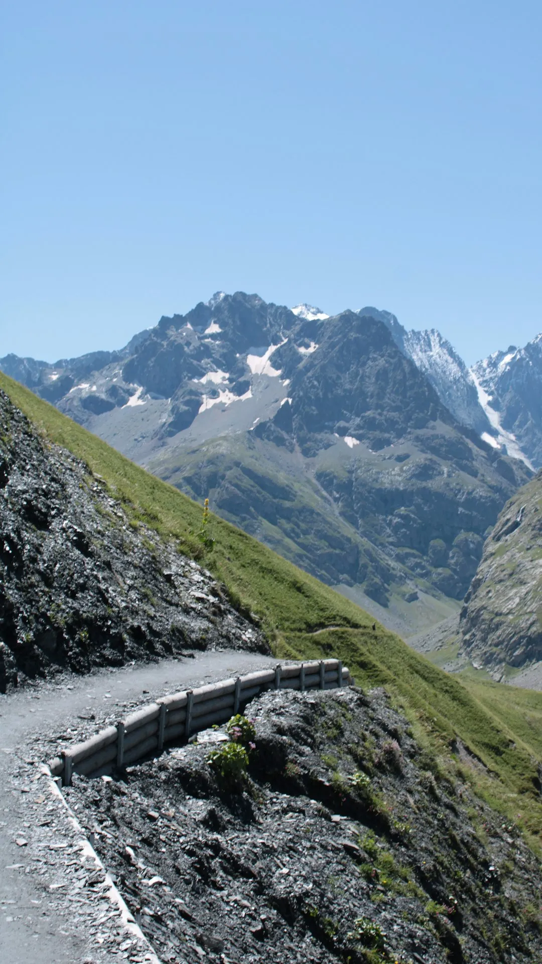
The Tour de l'Aiguille Rouge is a demanding multi-day trek in the French Alps, charting a course through the heart of the Vanoise National Park. This challenging route circumnavigates the imposing Aiguille Rouge massif, offering a spectacular immersion into high-alpine landscapes characterised by rugged peaks, vast glaciers, and vibrant alpine meadows. Designed for experienced hikers with a good level of fitness and a head for heights, the tour typically spans five to seven days, covering approximately 65 kilometres with a significant elevation gain of 5,000 metres. The journey winds through a dramatic terrain of scree slopes, rocky ridges, and high mountain passes, providing breathtaking panoramas of the surrounding Savoyard Alps.
- Distance: 65.0 km
- Elevation Gain: 5,000 m
- Duration: 5-7 days
- Difficulty: Challenging
- Best Time: July to September
- Closest City: Bourg-Saint-Maurice
- Trailhead Access: Nearest airport: Geneva (GVA). Take a train to Bourg-Saint-Maurice. From Bourg-Saint-Maurice, take a local bus or taxi to the start of hiking trails around Aiguille Rouge. Road conditions are generally good to Bourg-Saint-Maurice. Parking available in Bourg-Saint-Maurice. Check local regulations for permits or registration at trailhead.
- Coordinates: 45.5713, 6.7739
Overview
The Tour de l'Aiguille Rouge is not a single, well-trodden path but rather a collection of interconnected trails and high mountain routes that form a grand circuit around the Aiguille Rouge and its neighbouring peaks. This trek is renowned for its raw, untamed beauty and the sheer scale of its alpine environment. Unlike more manicured trails, this route often involves navigating scree fields, crossing snow patches (even in summer), and ascending steep, rocky ascents to reach breathtaking viewpoints. The elevation gain of 5,000 metres over 65 kilometres highlights the relentless nature of the terrain, demanding strong legs and a resilient spirit.
The Vanoise National Park, established in 1963, is France's first national park and a sanctuary for alpine wildlife, including ibex, chamois, marmots, and a rich diversity of alpine flora. Hikers on the Tour de l'Aiguille Rouge have the opportunity to witness these creatures in their natural habitat, often at close range. The landscape is a testament to glacial activity, with U-shaped valleys, cirques, and moraines shaping the dramatic topography. The route offers a profound sense of remoteness, with long stretches where human presence is minimal, allowing for a deep connection with the wild alpine world.
The trek's difficulty is amplified by the unpredictable mountain weather. Sunshine can quickly give way to thunderstorms, fog, or even snow, requiring constant vigilance and preparedness. The reward for this effort is unparalleled: sweeping vistas of the Mont Blanc massif, the Tarentaise Valley, and countless other iconic peaks of the French and Italian Alps. The sense of accomplishment upon completing this challenging circuit is immense, making it a sought-after objective for experienced mountaineers and trekkers.
History and Cultural Context
The region surrounding Aiguille Rouge has a long history of human interaction, primarily driven by pastoralism and mountaineering. For centuries, local communities in the Tarentaise Valley have utilised the high alpine pastures for grazing livestock during the summer months. The construction of 'alpages' (shepherd's huts) and the development of transhumance routes are testaments to this enduring relationship with the mountains. These traditional practices have shaped the landscape and left behind a rich cultural heritage, evident in the architecture of mountain villages and the enduring traditions of alpine farming.
The ascent of peaks like Aiguille Rouge itself became a focus for early mountaineers in the late 19th and early 20th centuries. As climbing techniques and equipment evolved, explorers and adventurers sought to conquer the highest and most challenging summits. The Vanoise region, with its extensive glaciers and rugged peaks, provided a perfect testing ground. The establishment of the Vanoise National Park in 1963 was a pivotal moment, aiming to protect this unique natural environment from the increasing pressures of tourism and development, while still allowing for responsible recreational use.
The Tour de l'Aiguille Rouge, as a defined circuit, is a more recent development, evolving from the network of existing hiking trails, shepherd's paths, and high-altitude routes. It represents a modern approach to experiencing the Vanoise, combining the challenge of a multi-day trek with the opportunity to explore diverse alpine ecosystems and witness the grandeur of the French Alps. The route often passes by remnants of past human activity, such as old stone shelters or abandoned mining sites, offering glimpses into the region's historical connection with the mountains.
Seasonal Highlights and Weather Reality
The optimal season for undertaking the Tour de l'Aiguille Rouge is from July to September. During these months, the snow generally recedes from the higher passes, making the trails more accessible and safer. The alpine meadows are typically in full bloom, creating a vibrant tapestry of colours against the stark, rocky backdrop.
July: The early part of the season often sees lingering snow patches, particularly on north-facing slopes and at higher elevations. However, the landscape is usually lush and green, and wildlife is abundant. The days are long, providing ample daylight for hiking. Weather can be variable, with a higher chance of late-season snowfalls or thunderstorms.
August: This is generally considered the peak of the summer season. Snow cover is at its minimum, and the weather is often at its most stable, though thunderstorms remain a significant concern, especially in the afternoons. The alpine flowers are at their most spectacular, and the chances of spotting wildlife are high. This is also the busiest month for hikers.
September: The autumn colours begin to emerge in the lower valleys, and the air becomes crisper. The crowds thin out, offering a more serene hiking experience. However, the days are shorter, and the risk of early snowfalls on the higher passes increases significantly as the month progresses. Temperatures can drop considerably, especially at night.
Weather Considerations: Mountain weather is notoriously unpredictable. Even during the summer months, hikers must be prepared for rapid changes. Afternoon thunderstorms are common, often accompanied by lightning, heavy rain, and strong winds. Hypothermia is a risk, even in summer, due to altitude and wind chill. It is crucial to check the weather forecast daily and be prepared to alter your plans if conditions deteriorate.
Recommended Itinerary
5-Day Tour de l'Aiguille Rouge Itinerary (Challenging Pace)
Day 1: Bourg-Saint-Maurice to Refuge de la Femma
- Distance: 12 km
- Elevation gain: 1,500 m
- Time: 6-7 hours
- Start from a convenient point near Bourg-Saint-Maurice (e.g., Funi 2000 access point)
- Steep ascent through forests and then open alpine pastures
- Pass through the hamlet of Funi 2000
- Arrive at Refuge de la Femma (2,000 m), a well-equipped mountain refuge
- This day is a significant climb to gain altitude quickly and acclimatise
Day 2: Refuge de la Femma to Refuge du Col de la Croix du Bonhomme
- Distance: 15 km
- Elevation gain: 1,000 m, Elevation loss: 600 m
- Time: 7-8 hours
- Traverse high alpine terrain with stunning views
- Cross several passes, including the Col de la Femma
- Potential for snow patches early in the season
- Arrive at Refuge du Col de la Croix du Bonhomme (2,443 m), a historic refuge with panoramic views
- This day involves significant ascents and descents over exposed ridges
Day 3: Refuge du Col de la Croix du Bonhomme to Refuge des Lacs Merlet
- Distance: 10 km
- Elevation gain: 700 m, Elevation loss: 500 m
- Time: 5-6 hours
- Continue along the high mountain trails
- Pass by beautiful alpine lakes, offering opportunities for reflection and photography
- The route may involve some scree slopes and rocky sections
- Arrive at Refuge des Lacs Merlet (2,200 m), situated near picturesque alpine lakes
- A more moderate day in terms of distance but still with significant elevation changes
Day 4: Refuge des Lacs Merlet to Refuge du Mont Pourri
- Distance: 13 km
- Elevation gain: 1,200 m
- Time: 7-8 hours
- A challenging day with a substantial climb towards the Aiguille Rouge massif
- Navigate through rugged, high-altitude terrain
- Potential for encountering wildlife such as ibex and chamois
- Arrive at Refuge du Mont Pourri (2,370 m), offering commanding views of the surrounding peaks
- This day is a significant test of endurance and navigation skills
Day 5: Refuge du Mont Pourri to Bourg-Saint-Maurice
- Distance: 15 km
- Elevation loss: 1,800 m
- Time: 5-6 hours
- Descend from the refuge back towards Bourg-Saint-Maurice
- The descent can be steep and demanding on the knees
- Pass through varied terrain, from high alpine to forest
- Arrive back in Bourg-Saint-Maurice, completing the circuit
- A final day of significant descent, requiring careful footing
Important Notes:
- This itinerary is a suggestion and can be adapted based on fitness, weather, and personal preference.
- Refuge bookings are essential, especially during peak season.
- Carry sufficient water and food, as resupply points are limited.
- Be prepared for all types of mountain weather.
- Navigation skills are crucial, as some sections may be poorly marked or involve off-trail navigation.
Planning and Bookings
Book Your Trip
Everything you need to plan your journey
Accommodation
Find places to stay near Bourg-Saint-Maurice
Flights
Search flights to Bourg-Saint-Maurice
Essential Preparation
The Tour de l'Aiguille Rouge is a serious undertaking that requires meticulous planning. Given its challenging nature and remote locations, thorough preparation is paramount. This includes assessing your physical fitness, ensuring you have the correct gear, and understanding the logistics of reaching the trailhead and arranging accommodation. The closest major town and transport hub is Bourg-Saint-Maurice, which offers a range of services, including accommodation, gear shops, and restaurants. From Bourg-Saint-Maurice, local buses or taxis can transport you to various starting points for the trek, depending on the chosen itinerary. It is advisable to spend at least one night in Bourg-Saint-Maurice before and after your trek to allow for acclimatisation, last-minute preparations, and to recover from the journey.
Trail Accommodation
Accommodation along the Tour de l'Aiguille Rouge primarily consists of mountain refuges ('refuges de montagne'). These are typically staffed during the summer season and offer basic but comfortable lodging, usually in dormitory-style rooms with bunk beds. Some refuges may also offer camping facilities nearby.
Refuge Facilities:
- Bunk beds with mattresses (sleeping bags are mandatory)
- Common dining area
- Often a bar serving drinks and sometimes snacks
- Toilets (may be basic or composting)
- Access to water (stream water is common; treatment is recommended)
- Some refuges offer half-board (dinner and breakfast) which is highly recommended for convenience and nutrition.
What's NOT Provided:
- Bed linen (sheets and pillowcases) – a sleeping bag liner is usually sufficient, but a full sleeping bag is essential.
- Cooking equipment or food for self-catering (unless specified by the refuge).
- Electricity for charging devices is often limited or unavailable.
- Showers are not always available or may be cold.
Booking Requirements:
- Bookings are essential for all refuges, especially during July and August. It is advisable to book several months in advance.
- Contact refuges directly via phone or email to make reservations. Websites often provide contact details.
- Seasonal availability: Refuges are typically open from mid-June to mid-September, but dates can vary. Always confirm opening and closing dates.
- Costs: Expect to pay approximately €40-€70 per person per night for a dormitory bed, with half-board costing an additional €20-€30.
Campsites: Wild camping is generally discouraged or prohibited within national parks. However, some refuges may have designated camping areas nearby. Always check local regulations.
Required Gear
- Sturdy hiking boots: Waterproof, broken-in, with good ankle support.
- Backpack: 40-60 litre capacity, with a rain cover.
- Waterproof jacket and trousers: Essential for protection against rain and wind.
- Warm layers: Fleece jacket, thermal base layers (merino wool or synthetic).
- Hat and gloves: Even in summer, temperatures can drop significantly at altitude.
- Sleeping bag: A 3-season bag (rated to 0-5°C comfort) is recommended.
- Head torch: With spare batteries, for use in refuges and early morning starts.
- First-aid kit: Including blister treatment, pain relievers, antiseptic wipes, and any personal medications.
- Navigation tools: Map of the area, compass, and a GPS device or smartphone with offline maps.
- Sun protection: High SPF sunscreen, sunglasses, and a wide-brimmed hat.
- Trekking poles: Highly recommended for stability on ascents and descents, and to reduce strain on knees.
What to Bring
- Food: High-energy snacks (nuts, dried fruit, energy bars), packed lunches for days when you are not eating at a refuge.
- Water bottles or hydration reservoir: Capacity of at least 2 litres per person.
- Water purification method: Filter or purification tablets, as stream water should be treated.
- Toiletries: Biodegradable soap, toothbrush, toothpaste, small towel, hand sanitiser.
- Personal items: Camera, power bank for electronics, book or journal.
- Cash: For refuges that may not accept credit cards, and for small purchases in villages.
- Insect repellent: Especially for lower altitudes and evenings.
- Emergency whistle.
- Duct tape: Useful for repairs.
Permits
For the Tour de l'Aiguille Rouge, specific permits are generally not required for hiking the trails themselves, as much of the route passes through public land and the Vanoise National Park. However, there are important considerations regarding access and accommodation:
Vanoise National Park Regulations: While hiking is permitted, there are regulations in place to protect the park's environment. These typically include rules against camping outside designated areas, disturbing wildlife, and leaving any trace of your passage. Always familiarise yourself with the latest park regulations before your trip. Information can usually be found on the official Vanoise National Park website or at visitor centres.
Refuge Bookings: As detailed in the accommodation section, booking your stays in mountain refuges is the most critical "permit" requirement for this trek. These bookings are essential and should be made well in advance, particularly for the peak season (July-August). Failure to book can mean being turned away from refuges, which are often the only viable accommodation options on the route.
Access Points: While no specific permits are needed to start hiking from points like Bourg-Saint-Maurice, ensure you understand any local access rules or parking regulations if you are driving to a trailhead. Some areas might have seasonal restrictions or require a small fee for parking.
Wildlife Observation: The Vanoise National Park is a protected habitat for numerous species. While no permits are needed to observe wildlife, it is crucial to do so responsibly. Maintain a safe distance, do not feed animals, and avoid making excessive noise that could disturb them.
General Advice: Always check the official Vanoise National Park website or contact local tourist information offices for the most up-to-date information on regulations, trail conditions, and any specific requirements that may apply to your chosen route and dates of travel.
Other Activities in the Area
The Tarentaise Valley and the surrounding Vanoise region offer a wealth of activities beyond the Tour de l'Aiguille Rouge, making it an excellent destination for an extended stay:
- Skiing and Snowboarding: In winter, the area is a world-renowned ski destination, with resorts like Les Arcs, La Plagne, and Val Thorens offering vast ski areas.
- Mountain Biking: The lower slopes and valleys are crisscrossed with dedicated mountain biking trails, catering to all levels of experience.
- Via Ferrata: Several routes are available in the vicinity, offering a thrilling way to experience the cliffs and rock faces.
- Paragliding: The thermals in the Tarentaise Valley are ideal for paragliding, providing spectacular aerial views of the Alps.
- Rock Climbing: Numerous climbing routes exist on the various rock faces in the region, from beginner-friendly crags to challenging multi-pitch ascents.
- Cultural Exploration: Visit charming alpine villages such as Sainte-Foy-Tarentaise, discover local markets, and sample regional Savoyard cuisine.
- Lake Activities: In the warmer months, lakes like Lac de Roselend offer opportunities for swimming, sailing, and fishing.
- Glacier Hiking and Mountaineering: For those seeking further high-altitude challenges, guided glacier hikes and mountaineering expeditions can be arranged in the Vanoise.
Safety and Conditions
Pre-Trip Checks:
- Weather Forecast: Always check the most up-to-date mountain weather forecast (e.g., Météo-France) before and during your trek. Be prepared for rapid changes, including thunderstorms, fog, and snow, even in summer.
- Trail Conditions: Consult local tourist offices or park authorities for information on current trail conditions, especially regarding snow cover on passes, potential rockfall, or any temporary closures.
- Emergency Contacts: Save local emergency numbers (SAMU: 15, Pompiers: 18, European emergency number: 112) on your mobile phone.
On the Trail:
- Navigation: The Tour de l'Aiguille Rouge can involve challenging terrain and sometimes poorly marked paths. Carry a map and compass, and know how to use them. A GPS device or smartphone with offline maps is highly recommended.
- Altitude: Be aware of the symptoms of altitude sickness (headache, nausea, dizziness). Ascend gradually, stay hydrated, and descend if symptoms worsen.
- Terrain: Be cautious on scree slopes, rocky sections, and any snow patches. Wear appropriate footwear and use trekking poles for stability.
- Water: Always treat water from streams and rivers before drinking, even if it looks clear.
- Wildlife: Maintain a respectful distance from all wildlife. Do not feed animals, as this can harm their health and alter their natural behaviour. Be aware of potential encounters with chamois or ibex, especially on higher routes.
- Hypothermia: Even in summer, temperatures at altitude can drop significantly, especially with wind and rain. Carry sufficient warm layers and waterproofs, and know the signs of hypothermia.
- Communication: Mobile phone reception can be intermittent or non-existent in many parts of the Vanoise. Consider carrying a personal locator beacon (PLB) or satellite messenger for emergencies in remote areas.
Refuge Safety: Follow the instructions of refuge wardens regarding safety procedures, especially concerning cooking, waste disposal, and behaviour within the refuge.
Travel Insurance: Ensure your travel insurance covers high-altitude trekking and potential emergency evacuation. This is crucial for a trek of this nature.
Side Trips and Points of Interest
Aiguille Rouge Summit (Optional): For highly experienced mountaineers with appropriate gear and knowledge, a summit attempt of Aiguille Rouge (3,227 m) can be a significant undertaking. This requires advanced climbing skills, glacier travel experience, and often a guide. The views from the summit are said to be unparalleled, offering a 360-degree panorama of the surrounding Alps.
Lac de la Plagne: A beautiful alpine lake often visited on routes around the Aiguille Rouge. Its clear waters and surrounding mountain scenery make it a picturesque spot for a rest or a picnic lunch.
Col de la Croix du Bonhomme: This historic pass is not only a waypoint but also a point of interest in itself. It has been a crossing point for centuries and offers expansive views. The refuge here is a significant landmark.
Alpine Flora and Fauna: The Vanoise National Park is a haven for biodiversity. Keep an eye out for marmots whistling their alarm calls, chamois and ibex grazing on the slopes, and a stunning array of alpine flowers, especially in July and August. The park is also home to eagles and other birds of prey.
Shepherd's Huts (Alpages): Along the route, you may encounter traditional shepherd's huts. These offer a glimpse into the historical pastoral life of the region. Some may be in use during the summer months, while others are remnants of past activity.
Panoramic Viewpoints: Numerous points along the trail offer breathtaking vistas. Take time to pause at designated viewpoints or natural clearings to absorb the grandeur of the Tarentaise Valley, the Mont Blanc massif in the distance, and the rugged peaks of the Vanoise.
Leave No Trace
The Tour de l'Aiguille Rouge traverses a pristine alpine environment within the Vanoise National Park. Adhering to Leave No Trace principles is paramount to preserving this fragile ecosystem for future generations. Your actions directly impact the wilderness you are experiencing.
Plan Ahead and Prepare: Understand the route, weather, and regulations. Pack appropriately to avoid needing to improvise with potentially damaging methods. Make informed decisions about your trip.
Travel and Camp on Durable Surfaces: Stick to marked trails whenever possible. If camping is permitted in designated areas, use established sites. Avoid trampling vegetation, especially in meadows where flowers are delicate.
Dispose of Waste Properly: Pack out everything you pack in, including all food scraps, wrappers, and toilet paper. Use designated toilets in refuges. If no facilities are available, dig catholes at least 60 metres away from water sources, trails, and campsites.
Leave What You Find: Do not remove rocks, plants, or any natural or cultural objects. Leave them for others to enjoy and for the ecosystem to thrive.
Minimise Campfire Impacts: Campfires are generally prohibited in national parks and above the treeline. If permitted in specific areas, use existing fire rings and keep fires small. Ensure they are completely extinguished before leaving.
Respect Wildlife: Observe animals from a distance. Never feed them, as this can alter their natural behaviour and diet, and can be harmful to their health. Store food securely to prevent attracting animals.
Be Considerate of Other Visitors: Keep noise levels down, especially in refuges and natural areas. Yield to other hikers on narrow trails. Respect the solitude and natural quiet of the mountains.
By following these principles, you contribute to the conservation of the Vanoise National Park and ensure that the Tour de l'Aiguille Rouge remains a wild and beautiful experience.