Toubkal Circuit - The Roof of North Africa
The Toubkal Circuit is the definitive high-altitude trekking experience in Morocco’s High Atlas Mountains, offering a profound journey through a landscape that feels suspended between the Mediterranean and the Sahara. While many visitors opt for the direct two-day ascent of Jebel Toubkal, the full circuit is a 60-kilometre odyssey that provides a far more immersive and culturally rich encounter with the "Land of the Berbers." This six-to-seven-day trek circumnavigates the highest peak in North Africa (4,167 metres), traversing high mountain passes, descending into lush green valleys, and passing through ancient stone villages where life has remained largely unchanged for centuries. It is a journey of dramatic contrasts: from the scorched, red-rock ridges and scree slopes of the high passes to the cool, walnut-shaded groves and terraced fields of the valley floors.
Unlike the more crowded direct route, the Toubkal Circuit allows for proper acclimatisation and a deeper understanding of the Imazighen (Berber) culture. The route is physically demanding, involving over 4,000 metres of total elevation gain and crossing several passes exceeding 3,000 metres. However, the reward is a panoramic view of the Atlas range that stretches toward the Atlantic coast in the west and the Sahara Desert in the south. This is not merely a mountain climb; it is a traverse of a living landscape where the hospitality of the local people is as legendary as the ruggedness of the terrain. For those seeking a challenge that combines technical trekking with genuine cultural exchange, the Toubkal Circuit stands as one of the premier multi-day walks in the world.
- Distance: 60.0 km (approximate circuit length)
- Duration: 6–7 days
- Season: April to May and September to October (optimal windows)
- Accommodation: Mountain refuges, village gîtes, and wild camping
- Highest point: Jebel Toubkal Summit (4,167 m)
- Difficulty: Challenging (requires high fitness and altitude resilience)
- Access: Imlil (90 minutes from Marrakech)
Overview
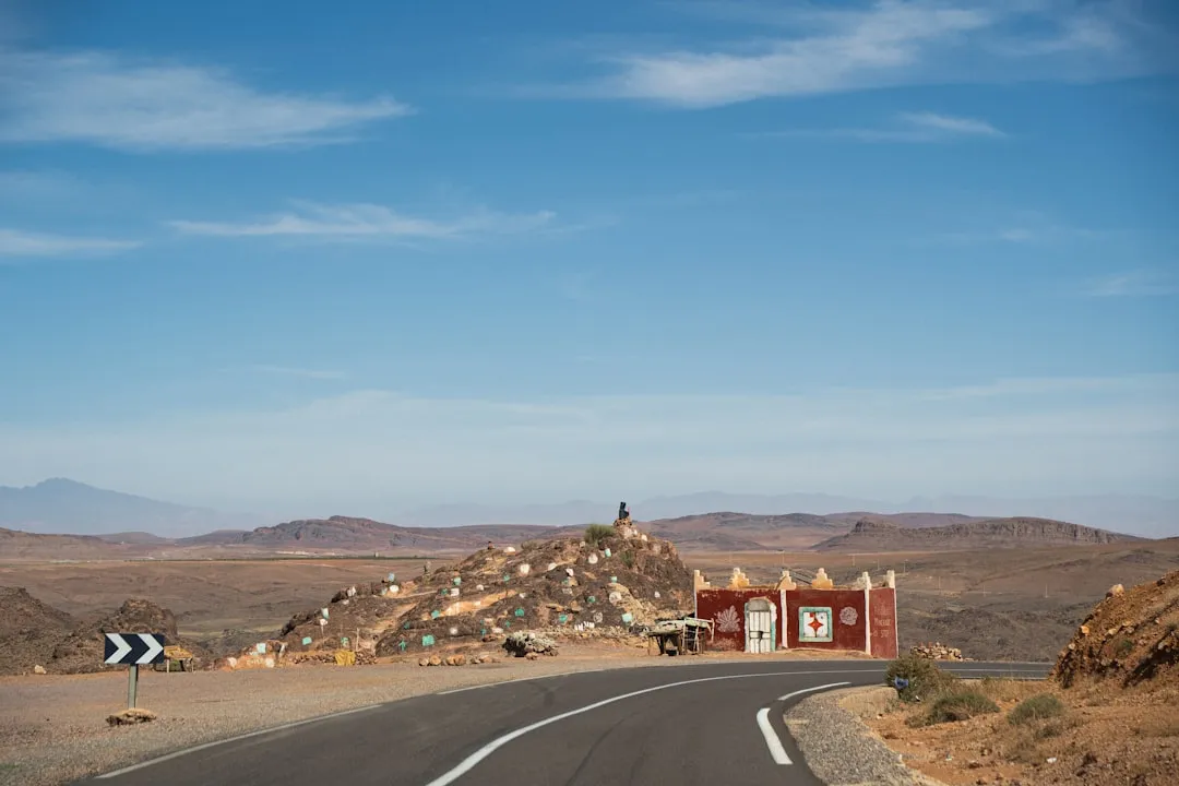
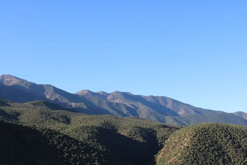
The Toubkal Circuit is a masterclass in mountain geography. The High Atlas range, often called the "Idraren Draren" (Mountains of Mountains) by the local Berber population, forms a formidable barrier between the mild coastal plains and the harsh pre-Saharan interior. Walking the circuit provides a front-row seat to this geological transition. The trek typically begins in the bustling trailhead of Imlil, a village perched at 1,740 metres, surrounded by walnut trees and apple orchards. From here, the path climbs steadily, leaving the greenery behind in favour of the stark, volcanic beauty of the high peaks.
The circuit is defined by its "Tizis" (mountain passes). Each day involves a significant ascent to a pass, followed by a long descent into a new valley system. This "yo-yo" profile is excellent for building red blood cells and preparing the body for the final push to the 4,167-metre summit. You will cross the Tizi n'Tacheddirt (3,172 m), the Tizi n'Likemt (3,555 m), and the Tizi n'Ourai (3,109 m), each offering a unique perspective on the massif. The terrain varies from well-trodden mule tracks to steep, shifting scree slopes that require careful footwork and trekking poles.
Culturally, the trek is an eye-opening experience. The Berber villages of Tacheddirt, Amsouzert, and Armed are architectural marvels, with houses built of local stone and earth, seemingly growing out of the mountainsides. The irrigation systems (seguias) that channel snowmelt to terraced fields of barley and vegetables are a testament to the ingenuity of the mountain people. Throughout the trek, the presence of the local guides and muleteers is central to the experience. Their knowledge of the weather patterns, the best water sources, and the intricate trail networks is indispensable. The Toubkal Circuit is a journey that demands physical stamina and mental fortitude, but it returns the investment with some of the most spectacular alpine scenery on the African continent.
History and Cultural Context
The High Atlas Mountains have been the ancestral home of the Imazighen (Berber) people for millennia. Long before the arrival of Arab influences or European explorers, these mountains served as a natural fortress, allowing the Berber tribes to maintain their distinct language (Tamazight), customs, and social structures. The history of the Toubkal region is inextricably linked to the resilience of these mountain communities, who have adapted to one of the most challenging environments on Earth through sophisticated agricultural techniques and a deeply ingrained culture of hospitality.
In the context of modern mountaineering, Jebel Toubkal remained largely "undiscovered" by the Western world until the early 20th century. While local shepherds and hunters had undoubtedly roamed the lower slopes for centuries, the first recorded ascent of the summit by Europeans did not occur until 1923. This expedition was led by the Marquis de Segonzac, along with Vincent Berger and Hubert Dolbeau. Following this, the French Alpine Club (Club Alpin Français) began to take an interest in the region, constructing the first mountain refuges in the 1930s to facilitate exploration and climbing. This colonial-era infrastructure laid the groundwork for the modern trekking industry that supports the local economy today.
The cultural significance of the mountains remains paramount. To the local people, the peaks are not just physical challenges but are often associated with local saints and legends. The village of Sidi Chamharouch, which trekkers pass on the way to the Toubkal Refuge, is home to a famous shrine built around a large white-painted boulder. It is a site of pilgrimage for many Moroccans, believed to have healing properties for those possessed by "djinn" (spirits). Understanding this blend of Islamic faith and ancient mountain animism adds a layer of depth to the trek. Today, the Toubkal National Park, established in 1942, aims to preserve both the unique biodiversity of the region—including the endangered Barbary sheep—and the cultural heritage of the villages that dot its valleys.
Want more background? Read extended notes on history and cultural context → Learn more
Seasonal Highlights and Weather Reality
Timing is everything when planning a Toubkal Circuit trek. The High Atlas experiences an alpine climate that can be surprisingly extreme, given its proximity to the Sahara. The "best" times to visit are the shoulder seasons of spring and autumn, but each window offers a different experience.
Spring (April to May): This is arguably the most beautiful time to trek. The valleys are in full bloom, the almond and cherry trees are flowering, and the lower slopes are a vibrant green. However, this is also a period of transition. Significant snow remains on the high passes and the summit of Toubkal until late May. Trekkers in April should be prepared for winter conditions above 3,000 metres, often requiring crampons and ice axes. The weather can be unpredictable, with afternoon thunderstorms common as the heat begins to rise in the plains.
Autumn (September to October): This is the most stable period for weather. The summer heat has dissipated, and the winter snows have not yet arrived. The air is often exceptionally clear, providing the best long-distance views. The landscape is drier and more rugged in appearance than in spring, but the harvest season in the villages brings a unique cultural energy to the trek. This is the peak season for the circuit, so refuges can be busy.
Summer (June to August): While trekking is possible, the heat in the lower valleys can be punishing, with temperatures often exceeding 35°C. High-altitude sections remain cool, but the lack of shade on the long climbs to the passes makes for a gruelling experience. This is, however, the best time for those who wish to avoid snow entirely without needing technical winter gear.
Winter (November to March): During these months, the Toubkal Circuit becomes a serious winter mountaineering undertaking. The passes are buried in deep snow, and avalanche risk is a genuine concern. Temperatures at the refuges can drop to -15°C or lower. This season is strictly for those with winter mountain skills, proper alpine equipment, and experienced guides. The circuit is rarely completed in its entirety during mid-winter due to the difficulty of the high passes; most visitors stick to the direct Toubkal ascent.
Recommended Itinerary
7-Day Toubkal Circuit Itinerary
Day 1: Imlil to Tacheddirt
- Distance: 8 km
- Elevation gain: 600 m
- Time: 4–5 hours
- Start in Imlil (1,740 m) after a morning transfer from Marrakech
- Climb steadily toward the Tizi n'Tamatert pass (2,279 m)
- Enjoy views of the Imenane Valley and the peaks of Ouanoukrim
- Descend slightly into the village of Tacheddirt (2,314 m), the highest village in the Atlas
- Stay in a local village gîte; experience traditional Berber hospitality and mint tea
- A gentle introduction to the altitude and the rhythm of the trek
Day 2: Tacheddirt to Azib Likemt
- Distance: 10 km
- Elevation gain: 1,250 m
- Time: 6–7 hours
- A challenging day involving the ascent of Tizi n'Likemt (3,555 m)
- The trail is steep and follows a series of long zigzags up a scree-covered slope
- Spectacular views from the pass back toward the Imlil Valley and forward to the central massif
- Long descent to the summer pastures of Azib Likemt (2,600 m)
- Camp near the river or stay in basic stone shelters used by shepherds
- This day is crucial for acclimatisation, pushing well above 3,000 metres
Day 3: Azib Likemt to Amsouzert
- Distance: 12 km
- Elevation gain: 500 m
- Time: 6 hours
- Trek through the Tinzar Valley, a remote and rarely visited section of the range
- Cross the Tizi n'Ourai (3,109 m) for your first clear view of the southern face of Jebel Toubkal
- Descend into the lush and beautiful Ifni Valley
- Arrive in the village of Amsouzert (1,740 m), one of the most picturesque villages in the region
- Stay in a village gîte; enjoy the contrast of the green walnut groves after the high-altitude desert
Day 4: Amsouzert to Lake Ifni
- Distance: 6 km
- Elevation gain: 550 m
- Time: 3–4 hours
- A shorter day allowing for rest and recovery
- Walk through the valley, passing small hamlets and terraced fields
- Arrive at Lake Ifni (2,295 m), the only large lake in the High Atlas, surrounded by towering cliffs
- Afternoon spent relaxing by the lake; brave trekkers can take a cold swim
- Wild camping by the lakeshore under a spectacular canopy of stars
Day 5: Lake Ifni to Toubkal Refuge via Tizi n'Ouanaoums
- Distance: 8 km
- Elevation gain: 1,350 m
- Time: 6–7 hours
- The most demanding day of the circuit, involving a steep climb up a narrow gorge
- Ascend to the Tizi n'Ouanaoums (3,664 m), a dramatic notch in the ridgeline
- The path is rocky and requires careful footwork, especially if snow is present
- Descend to the Neltner/Toubkal Refuges (3,207 m)
- The refuges are the "base camp" for the summit push, bustling with trekkers from all over the world
Day 6: Summit Jebel Toubkal and return to Refuge
- Distance: 7 km (return)
- Elevation gain: 960 m
- Time: 5–7 hours
- Early alpine start (usually 5:00 AM) to reach the summit for sunrise and avoid afternoon clouds
- The climb is a non-technical but strenuous slog up a steep scree slope (the South Cirque)
- Reach the summit of Jebel Toubkal (4,167 m); on clear days, views extend to the Sahara and the Atlantic
- Descend back to the refuge for a well-earned lunch and a second night of rest
- Optional: Strong trekkers can descend all the way to Imlil, but staying at the refuge is recommended for safety
Day 7: Toubkal Refuge to Imlil
- Distance: 10 km
- Elevation loss: 1,450 m
- Time: 4–5 hours
- A long but easy descent following the well-maintained main trail
- Pass the shrine of Sidi Chamharouch (2,350 m)
- Continue down to the village of Armed and finally back to Imlil
- Lunch in Imlil before a private transfer back to the vibrant chaos of Marrakech
- Celebrate the completion of the circuit with a traditional hammam and dinner
Important Notes:
- A local guide is mandatory for all trekkers in the Toubkal region (regulations introduced in 2018)
- Mules are used to carry heavy bags; trekkers only carry a daypack
- Altitude sickness is a real risk; stay hydrated and communicate any symptoms to your guide
- Water must be treated or filtered; do not drink directly from streams
- The itinerary can be adjusted to 6 days by combining Day 6 and 7, but this is physically exhausting
Planning and Bookings
Book Your Trip
Everything you need to plan your journey
Accommodation
Find places to stay near Marrakech
Flights
Search flights to Marrakech
Essential Preparation
Planning a Toubkal Circuit requires more than just physical training; it requires careful logistical coordination. Most trekkers use Marrakech as their base. It is recommended to spend at least two nights in Marrakech before the trek to adjust to the heat and organise your final supplies. From Marrakech, a 90-minute transfer by "grand taxi" or private minibus takes you to Imlil, the gateway to the High Atlas.
Physical fitness is paramount. You should be comfortable walking for 6–8 hours a day for several consecutive days, often on steep and uneven terrain. Training should include hill walking with a weighted pack and cardiovascular exercises. Since 2018, it has been a legal requirement for all foreign trekkers to be accompanied by a licensed local guide. These guides can be booked through reputable trekking agencies in Marrakech or directly in Imlil. They not only ensure your safety but also handle the logistics of hiring muleteers and arranging accommodation.
Trail Accommodation
The Toubkal Circuit offers a mix of accommodation styles, ranging from relatively comfortable village gîtes to basic mountain refuges and wild camping.
Village Gîtes: In villages like Tacheddirt and Amsouzert, you will stay in "Gîtes d'Etape." These are traditional Berber homes converted to host trekkers. They typically offer dormitory-style sleeping on floor mats or simple bunks, shared squat toilets, and sometimes a basic hot shower (for a small extra fee). Meals are communal and usually consist of tagine, couscous, and plenty of bread.
Mountain Refuges: At the base of Toubkal, there are two main refuges: the Refuge du Toubkal (managed by the French Alpine Club) and the privately-owned Les Mouflons. Both offer large dormitories, communal dining areas, and basic bathroom facilities. During peak season, these refuges are very crowded and noisy. Bookings are essential and are usually handled by your guide.
Camping: For the circuit, camping is often necessary, particularly at Azib Likemt and Lake Ifni. Your mule team will carry the tents, kitchen equipment, and food. Wild camping in the Atlas is a highlight, offering unparalleled views of the night sky, but be prepared for cold temperatures once the sun sets.
Facilities: Electricity is available in the villages but is non-existent or limited to solar power at the refuges and campsites. Charging phones or cameras may incur a small fee at the refuges. There is no WiFi on the trail, and mobile signal is intermittent at best.
Required Gear
- Trekking boots - high-cut with good ankle support and a stiff sole for scree slopes
- Sleeping bag - a 3-season bag (comfort rating -5°C) is essential, even in summer
- Trekking poles - highly recommended for the long descents and steep scree sections
- Waterproof jacket and trousers - breathable Gore-Tex or similar; mountain storms can be sudden
- Down jacket or heavy fleece - for cold evenings at the refuges and the summit push
- Daypack - 25–35 litres for your water, snacks, and layers (mules carry the rest)
- Head torch - essential for the early morning summit start and navigating refuges at night
- Sun protection - high SPF sunscreen, lip balm with UV protection, and Category 3 or 4 sunglasses
- Personal first aid kit - including blister pads (Compeed), rehydration salts, and ibuprofen
What to Bring
- Water purification - chlorine tablets or a filter (e.g., Sawyer Squeeze) are mandatory
- Snacks - energy bars, nuts, and dried fruit (can be bought in Marrakech or Imlil)
- Cash - Moroccan Dirhams (MAD) in small denominations for tips, showers, and soft drinks
- Toiletries - biodegradable soap, wet wipes, and a quick-dry travel towel
- Toilet paper and a lighter - to burn used paper (if not packing it out)
- Merino wool layers - base layers that stay warm when damp and resist odours
- Gloves and beanie - even in summer, the summit can be freezing at dawn
- Earplugs - essential for sleeping in crowded, noisy dormitories
- Portable power bank - to keep your phone/camera charged for the duration of the trek
Permits
There is no formal "permit" system in the same vein as the Inca Trail or the Milford Track, where numbers are strictly capped by a lottery. However, the Toubkal region is subject to specific security regulations that trekkers must follow. Since late 2018, it has been mandatory for all foreign nationals to be accompanied by a licensed Moroccan mountain guide to enter the Toubkal National Park and ascend the peak.
Checkpoints and Documentation:
- There are permanent police checkpoints at the entrance to Imlil and on the trail leading to the Toubkal Refuge (near Sidi Chamharouch).
- You must carry your original passport at all times. Your guide will present your details at these checkpoints.
- Independent trekking without a guide is strictly prohibited and will be stopped by local authorities.
Guide and Mule Costs:
- Licensed Guide: Expect to pay between 400 and 600 MAD per day, depending on the group size and the complexity of the route.
- Mule and Muleteer: Approximately 150–200 MAD per day. A mule can typically carry the gear of two trekkers (up to 40 kg).
- It is customary to tip your guide and muleteers at the end of the trek. A common guideline is 10–15% of the total trek cost, distributed among the staff.
Refuge Bookings: While no permit is needed, the refuges (Neltner and Les Mouflons) have limited capacity. During the peak months of May, September, and October, they can be fully booked weeks in advance. If you are trekking with an agency, they will handle these bookings. If you are organising your own guide, ensure they have confirmed your beds before you depart Imlil.
Other Activities in the Area
Morocco offers a wealth of experiences that complement a high-altitude trek. Consider these options for before or after your circuit:
- Marrakech Medina: Spend a few days lost in the souks, visit the Koutoubia Mosque, and experience the nightly spectacle of Jemaa el-Fnaa square with its storytellers, musicians, and food stalls.
- Traditional Hammam: There is no better way to soothe aching muscles after a 60 km trek than a traditional Moroccan scrub and massage in a local hammam.
- Ourika Valley: A shorter, greener valley closer to Marrakech, famous for its seven waterfalls at Setti Fatma and its vibrant Monday market.
- Rock Climbing: The granite cliffs around the Toubkal Refuge offer world-class alpine rock climbing routes for those with the necessary skills and equipment.
- Oukaimeden: Africa's highest ski resort is located nearby. In winter, it offers skiing; in summer, it is a great spot for viewing ancient petroglyphs (rock carvings).
- Essaouira: A three-hour drive from Marrakech, this coastal town offers a relaxed atmosphere, fresh seafood, and a chance to recover by the Atlantic Ocean.
Safety and Conditions
Altitude Sickness (AMS): This is the primary safety concern on the Toubkal Circuit. At 4,167 metres, the air contains significantly less oxygen than at sea level. Symptoms of Acute Mountain Sickness include headache, nausea, dizziness, and loss of appetite. The circuit itinerary is designed to aid acclimatisation by crossing high passes and sleeping lower, but it is not a guarantee. The only cure for AMS is descent. Inform your guide immediately if you feel unwell.
Weather Extremes: The High Atlas is notorious for rapid weather changes. A clear morning can turn into a violent thunderstorm or a blizzard within an hour. Hypothermia is a risk even in summer if you are caught in rain at high altitude without proper layers. Always follow your guide's advice regarding weather windows, especially for the summit push.
Terrain Hazards: The trails are often narrow and exposed. Scree slopes (loose rock) are common and can be treacherous on the descent, leading to twisted ankles or falls. Mules always have the right of way; when a mule train approaches, move to the "uphill" side of the trail to avoid being accidentally bumped off the edge.
Water and Hygiene: Do not drink untreated water from streams or village taps, as water-borne parasites are common. Use a reliable filtration system or purification tablets. Practice strict hand hygiene, especially before communal meals, to avoid "Berber Belly" (gastrointestinal upset).
Emergency Evacuation: There is no formal mountain rescue service in Morocco. In the event of a serious injury or illness, evacuation is typically conducted by mule to the nearest road head (Imlil), followed by a taxi to Marrakech. In extreme cases, a military helicopter may be requested, but this is rare and expensive. Ensure your travel insurance specifically covers "trekking up to 4,500 metres" and includes emergency heli-evacuation.
Side Trips and Points of Interest
Lake Ifni: This turquoise jewel is the only natural lake of significant size in the High Atlas. Formed by a massive landslide that blocked the valley, it sits at 2,295 metres, surrounded by sheer rock walls. It is a surreal sight in an otherwise arid landscape. Spending a night camping here is a highlight of the circuit, offering a sense of isolation and peace that is hard to find on the more popular routes.
Ouanoukrim Peaks: For those with extra energy and an extra day, the twin peaks of Ouanoukrim (Timzguida at 4,089 m and Ras n'Ouanoukrim at 4,083 m) offer a fantastic alternative or addition to Toubkal. The climb involves some light scrambling and provides what many consider to be a superior view of Jebel Toubkal itself.
Sidi Chamharouch: This small settlement on the way to the refuge is built around a massive white boulder. It is a place of deep spiritual significance for Moroccans. While non-Muslims are not permitted to enter the shrine itself, the surrounding village with its small shops selling "Berber Whiskey" (mint tea) and fresh orange juice is a fascinating place to observe local culture.
The "Window" of Tizi n'Ouanaoums: The final pass before reaching the Toubkal Refuge is a narrow, dramatic gap in the ridge. Standing in the "window" provides a breathtaking view back down to Lake Ifni, thousands of metres below, and forward to the jagged peaks of the Toubkal massif. It is one of the most photogenic spots on the entire circuit.
Leave No Trace
The High Atlas is a fragile ecosystem under increasing pressure from tourism and climate change. As a trekker, it is your responsibility to minimise your impact on this ancient landscape and its communities.
Environmental Responsibility:
- Pack out all trash, including micro-trash like cigarette butts and fruit peels. The high-altitude environment is too cold for organic waste to decompose quickly.
- Avoid buying bottled water in the mountains; the plastic waste is a major problem. Use filters or tablets instead.
- Stay on existing trails to prevent erosion and protect the sparse alpine vegetation.
- Use the toilets provided at gîtes and refuges. If you must go on the trail, ensure you are at least 50 metres from water sources and bury your waste deeply. Burn or pack out your toilet paper.
Social Responsibility:
- Always ask permission before taking photos of local people, especially women and children.
- Dress modestly. While the mountains are more relaxed than the cities, covering shoulders and knees is a sign of respect for the local culture.
- Avoid giving sweets or money directly to children, as it encourages begging and can lead to dental issues. If you wish to contribute, donate to a local school or village association.
- Respect the silence of the mountains. Avoid playing loud music and keep noise levels down in the communal areas of the refuges.