Torres del Paine (Base of the Towers) - The Crown Jewel of Patagonia
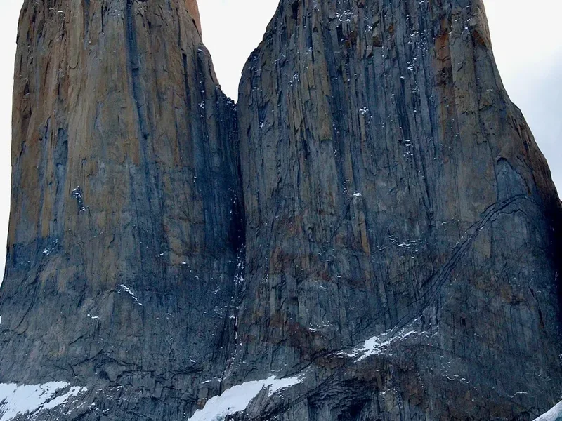
The trek to the Base de las Torres is arguably the most iconic day hike in the world. Located within the Torres del Paine National Park in Chile’s Magallanes Region, this 19-kilometre return journey leads hikers through the heart of the Almirante Nieto mountain massif to the base of three monolithic granite needles that pierce the Patagonian sky. These towers—Torre Sur (2,850 m), Torre Central (2,800 m), and Torre Norte (2,248 m)—stand as silent sentinels over a glacial lagoon of startling turquoise, creating a natural amphitheatre of rock and ice that has become the definitive symbol of South American wilderness. This is not merely a walk; it is a pilgrimage into a landscape defined by extreme geology, relentless winds, and the raw beauty of the Southern Andes. While many experience these towers as part of the multi-day 'W' or 'O' circuits, the dedicated day hike remains the most popular way to witness this geological marvel, demanding physical resilience and a deep respect for the volatile Patagonian climate.
- Distance: 19.0 km return
- Duration: 8–10 hours
- Elevation Gain: 900 m
- Difficulty: Challenging (steep moraine section at the end)
- Best Time: October to April (shoulder seasons of October/November and March/April offer fewer crowds)
- Highest Point: Mirador Base de las Torres (880 m)
- Trailhead: Hotel Las Torres / Welcome Centre (Sector Central)
- Closest City: Puerto Natales (120 km away)
Overview
The Base of the Towers trek is a masterclass in Patagonian diversity, transitioning from the golden pampas of the park’s lower reaches to the dense, wind-sculpted Lenga forests, and finally into a high-alpine world of grey granite and glacial silt. The trail is physically demanding, not necessarily because of its length, but due to the sustained elevation gain and the technical nature of the final kilometre. Hikers must ascend a steep, unstable glacial moraine—a graveyard of massive boulders deposited by retreating ice—to reach the hidden lagoon where the towers reside. The reward is a view that defies scale: three vertical granite walls rising nearly a vertical kilometre from the water's edge, often shrouded in swirling mists or illuminated by the fierce "fire" of a Patagonian sunrise.
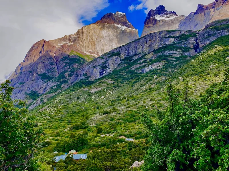
The landscape here is a product of intense tectonic activity and glacial erosion. The towers themselves are part of a granite laccolith—an igneous intrusion that was pushed up through the Earth's crust approximately 12 million years ago. Over millennia, the softer sedimentary rock that once covered the granite was stripped away by the relentless advance and retreat of glaciers, leaving behind the hard, resilient spires we see today. This geological history is visible in the "horns" (Cuernos) nearby, where dark sedimentary caps sit atop lighter granite bases, though at the Base of the Towers, the granite is the undisputed protagonist.
Walking this trail requires more than just physical fitness; it requires a strategic approach to the environment. The weather in Torres del Paine is legendary for its unpredictability, often described as "four seasons in one day." It is common to begin the hike in mild sunshine, encounter gale-force winds at the Paso del Viento, endure horizontal rain in the forest, and find snow at the summit. This volatility is part of the trek's character. The wind, in particular, is a constant companion, capable of reaching speeds over 100 kilometres per hour, turning a standard hike into a battle of endurance. Despite these challenges, the infrastructure of the park is well-developed, with clear signage and a well-trodden path that ensures the thousands of annual visitors can navigate the terrain safely while preserving the fragile sub-antarctic ecosystem.
History and Cultural Context
The human history of the Torres del Paine region is as layered as its geology. Long before the first European explorers arrived, the land was the ancestral home of the Aonikenk people, also known as the Tehuelche. These nomadic hunter-gatherers roamed the vast pampas east of the mountains, following the seasonal migrations of the guanaco (a wild relative of the llama). The name "Paine" itself is derived from the Aonikenk word for "blue," a reference to the striking colour of the glacial lakes that dot the landscape. To the Aonikenk, these mountains were sacred and formidable, a backdrop to a life lived in harmony with the harsh Patagonian elements.
European interest in the area began to peak in the late 19th century. One of the most famous early accounts came from Lady Florence Dixie, a British aristocrat and travel writer who visited in 1879. In her book, Across Patagonia, she referred to the three towers as the "Cleopatra’s Needles," bringing the first international attention to the region's unique topography. Following her, various explorers and scientists, including Otto Nordenskjöld, conducted surveys that mapped the glaciers and peaks, naming many of the landmarks after European benefactors or fellow explorers.
The 20th century saw the region transition from a wild frontier to a centre for sheep ranching (estancias). Large tracts of land were granted to settlers, and the baqueanos (Patagonian cowboys) became the masters of the terrain, navigating the valleys on horseback. It wasn't until 1959 that the Chilean government established the Parque Nacional de Turismo Lago Grey, which was later expanded and renamed Torres del Paine National Park in 1970. In 1978, UNESCO designated the park a Biosphere Reserve, recognising its unique ecological value. Today, the park is managed by CONAF (Corporación Nacional Forestal), which balances the preservation of the wilderness with the demands of being one of Chile's most visited tourist destinations. The trail to the Base of the Towers is the most visible legacy of this transition from indigenous hunting grounds to ranching frontier, and finally, to a globally protected wilderness area.
Want more background? Read extended notes on history and cultural context → Learn more
Seasonal Highlights and Weather Reality
The trekking season in Torres del Paine is strictly defined by the southern hemisphere's light and temperature cycles. While the park is technically open year-round, the experience of the Base of the Towers hike changes dramatically between the months.
Summer (December to February): This is the peak season. The days are incredibly long, with up to 18 hours of daylight, allowing for a relaxed pace and plenty of time at the lookout. However, this is also when the Patagonian winds are at their most ferocious. The "Williwaws"—sudden, violent gusts—can knock hikers off balance. Crowds are at their highest, and the trail can feel congested, particularly on the narrow moraine section. Temperatures typically range from 5°C to 18°C, but the wind chill can make it feel much colder.
Shoulder Seasons (October–November and March–April): Many experienced hikers consider these the best months. In spring (October–November), the wildflowers are in bloom, and the peaks are still heavily dusted with winter snow, providing a stunning contrast against the granite. In autumn (March–April), the Lenga forests turn a brilliant palette of fire-red and deep orange, creating some of the most spectacular photography opportunities in the world. The winds are generally less consistent than in mid-summer, though the weather remains unpredictable. Temperatures are cooler, often dipping below freezing at night.
Winter (May to September): This is a period for specialists. The trail is often covered in deep snow and ice, requiring crampons and sometimes snowshoes. Most of the park's infrastructure, including Refugio Chileno, closes or operates with minimal staff. Access to the Base of the Towers is often restricted to guided groups only for safety reasons. The days are short, and the weather can be brutal, with temperatures frequently dropping to -10°C or lower. However, for those with the right gear and experience, the reward is a silent, white wilderness and the chance to see the towers without another soul in sight.
Recommended Itinerary
Route Progression: Base of the Towers Day Hike
Phase 1: The Welcome Centre to Paso del Viento
- Distance: 3.5 km
- Elevation Gain: 250 m
- Time: 1–1.5 hours
- Start at the Welcome Centre (Sector Central) and follow the signs for "Base Las Torres."
- The trail begins with a gentle incline across open pampas, crossing a suspension bridge over the Ascencio River.
- The first major challenge is the "Cuesta del Viento" (Windy Slope). This is a sustained, steep climb up the side of Mount Almirante Nieto.
- As the name suggests, this section is highly exposed to the wind. Keep a low centre of gravity if gusts become severe.
- Reach the Paso del Viento, which offers the first expansive views back over Lake Nordenskjöld and the surrounding valleys.
Phase 2: Paso del Viento to Refugio Chileno
- Distance: 2 km
- Elevation: 150 m descent
- Time: 30–45 minutes
- From the pass, the trail levels out and then begins a steady descent into the Ascencio Valley.
- The path hugs the mountainside, with the Ascencio River roaring hundreds of metres below in the canyon.
- This section is relatively easy but requires care on the descent to protect the knees.
- Arrive at Refugio Chileno, a rustic mountain lodge nestled by the river. This is the last spot for treated water, toilets, and a snack before the final push.
Phase 3: Refugio Chileno to the Base of the Moraine
- Distance: 3 km
- Elevation Gain: 200 m
- Time: 1–1.5 hours
- After Chileno, the trail enters a beautiful, ancient Lenga (Southern Beech) forest.
- The gradient is moderate, with the forest providing a welcome shield from the wind and sun.
- The path crosses several small streams and follows the river upstream.
- Look out for Magellanic Woodpeckers (the largest in South America) which are often heard drumming on the trees.
- The forest section ends abruptly at a small wooden bridge, where the landscape transforms into a chaotic field of grey boulders.
Phase 4: The Final Ascent (The Moraine)
- Distance: 1 km
- Elevation Gain: 300 m
- Time: 45–60 minutes
- This is the most technical and physically demanding part of the hike.
- The trail climbs steeply through a massive glacial moraine. The "path" is often just a series of markers on large, sometimes unstable rocks.
- The gradient is roughly 30%, requiring slow, deliberate steps.
- In wet or icy conditions, this section can be slippery and dangerous. Trekking poles are highly recommended here.
- As you crest the final ridge, the three towers suddenly reveal themselves, towering over the turquoise lagoon.
Phase 5: The Return Journey
- Distance: 9.5 km
- Elevation: 900 m descent
- Time: 3.5–4.5 hours
- The return follows the same path. The descent of the moraine requires extreme focus to avoid ankle injuries.
- Stop at Refugio Chileno for a well-earned rest before the final climb back over the Paso del Viento.
- The final descent from the pass to the Welcome Centre can feel long on tired legs, but the views of the sunset over the pampas are often spectacular.
Important Notes:
- Start early (before 8:00 AM) to avoid the largest crowds and ensure you have enough daylight.
- The trail is well-marked with orange-tipped stakes and signs.
- Check the "last entry" time at the CONAF ranger station near Chileno; they often close the upper section of the trail in the afternoon for safety.
- Water from the streams in the forest section is generally considered safe to drink, but treatment is always the safest option.
Planning and Bookings
Book Your Trip
Everything you need to plan your journey
Accommodation
Find places to stay near Puerto Natales
Flights
Search flights to Puerto Natales
Essential Preparation
Preparation for the Base of the Towers begins in Puerto Natales, the gateway town for the park. You should arrive in Puerto Natales at least one or two days before your planned hike to organise transport, buy supplies, and check the latest weather forecasts. The hike is physically taxing, so a baseline level of cardiovascular fitness is required. If you are not used to 20-kilometre days with significant elevation, consider doing some training hikes with a weighted pack in the weeks leading up to your trip.
Logistically, you need to decide between taking the public bus or renting a car. Public buses depart Puerto Natales early (typically 6:30 AM or 7:00 AM) and take about two hours to reach the Laguna Amarga entrance. From there, you must take a shuttle bus (transfer) to the Sector Central/Hotel Las Torres area where the trailhead is located. If driving, ensure you have a full tank of petrol, as there are no fuel stations inside the park. The roads are mostly gravel and can be rough, so a vehicle with decent clearance is beneficial.
Trail Accommodation
While the Base of the Towers is a day hike, there are accommodation options on or near the trail for those who want to split the journey or start closer to the towers for sunrise.
Refugio Chileno: Located about 1.5 to 2 hours into the hike. It offers dormitory-style bunks and a campsite.
- Facilities: Hot showers (for guests), a restaurant serving hot meals, a small shop, and toilets.
- Booking: Managed by Las Torres Patagonia (formerly Fantastico Sur). Must be booked months in advance.
- Cost: High, reflecting the difficulty of supplying a mountain lodge by pack horse.
Camping Central / Refugio Torre Central: Located at the trailhead.
- Facilities: Large camping area, full-service refugio with bar and restaurant, hot showers, and electricity.
- Booking: Also managed by Las Torres Patagonia. Essential during peak season.
Hotel Las Torres: A luxury option at the trailhead for those who prefer a comfortable bed and fine dining after a long day on the trail.
Note: If you are doing this as a pure day hike from Puerto Natales, you do not need to book these accommodations, but you should be aware of them as emergency points or places to buy water and snacks.
Required Gear
- Trekking Boots: Sturdy, waterproof boots with good ankle support are non-negotiable. The moraine section is hard on the feet and requires excellent grip.
- Layered Clothing: Use the three-layer system. A moisture-wicking base layer (merino wool is best), an insulating mid-layer (fleece or down), and a high-quality waterproof and windproof outer shell.
- Trekking Poles: Highly recommended for the steep descent of the moraine and the Paso del Viento. They save your knees and provide stability in high winds.
- Head Torch: Essential if you plan to start before dawn for sunrise or if you are a slower hiker who might finish in the twilight.
- Backpack: A 20–30 litre daypack with a rain cover.
- Gloves and Beanie: Even in summer, the temperature at the base can be near freezing with the wind chill.
What to Bring
- Water: Carry at least 2 litres. While there are streams, having a dedicated supply is essential. A reusable bottle or hydration bladder is best.
- High-Energy Food: Bring a packed lunch plus plenty of snacks (nuts, chocolate, energy bars). You will burn a significant amount of calories.
- Sun Protection: The ozone layer is thin in southern Chile. Bring SPF 50+ sunscreen, lip balm with SPF, and polarised sunglasses.
- Personal First Aid: Blister plasters (Compeed), ibuprofen, and any personal medications.
- Identification and Park Permit: Keep your passport (or a clear photo of it) and your printed or digital "Paine Ticket" QR code accessible for ranger checks.
- Rubbish Bag: Everything you carry in must be carried out. There are no bins on the trail.
Permits
Access to Torres del Paine National Park requires a mandatory entrance fee, known as the "Paine Ticket." This must be purchased online in advance through the official CONAF portal. There is no option to buy tickets at the park gates, and mobile signal at the entrance is unreliable, so you must have your QR code downloaded or printed before leaving Puerto Natales.
Ticket Types and Costs (Subject to change):
- Adult International Visitor (up to 3 days): Approximately US$35–$40.
- Adult International Visitor (more than 3 days): Approximately US$45–$50.
- Chilean Residents: Significantly lower rates apply.
- Children: Reduced rates or free entry depending on age.
Booking Process:
- Visit the official aspticket.cl website.
- Select "Torres del Paine" and choose your entry date.
- Enter your personal details exactly as they appear on your passport.
- Pay via credit card. You will receive a PDF with a QR code.
- Important: You must also complete the "Declaración Jurada" (Customs/Health declaration) if required by current Chilean regulations, though for the park itself, the Paine Ticket is the primary requirement.
Ranger Checks: You will be required to show your QR code at the Laguna Amarga entrance. Additionally, CONAF rangers often staff a checkpoint near Refugio Chileno. They may ask to see your permit and will enforce "last entry" times for the final moraine section (usually 3:00 PM in summer) to ensure hikers aren't descending in the dark.
Other Activities in the Area
Torres del Paine is a massive park with much more to offer than just the towers. If you have extra days, consider these activities:
- The W Trek: A 4–5 day journey that includes the Base of the Towers, the French Valley, and Grey Glacier. This is the most famous multi-day trek in South America.
- Grey Glacier Boat Tour: Take a catamaran from Hotel Lago Grey to the face of the massive Grey Glacier, part of the Southern Patagonian Ice Field. You’ll see icebergs calving into the lake.
- Salto Grande and Cuernos Lookout: A much easier, flatter walk (about 2 hours return) that leads to a massive waterfall and a stunning viewpoint of the "Horns" of Paine.
- Wildlife Watching: The eastern side of the park (near Laguna Amarga) is the best place to spot guanacos, rheas (ostrich-like birds), and the elusive puma. Many specialist puma-tracking tours operate in this area.
- Kayaking: Paddle among the icebergs on Lake Grey or down the Serrano River for a different perspective on the massif.
- Horseback Riding: Experience the park like a true baqueano. Many estancias and Hotel Las Torres offer guided rides through the valleys and pampas.
Safety and Conditions
Weather Awareness: The single greatest danger in Torres del Paine is the weather. Hypothermia is a real risk even in summer if you get wet and the wind picks up. Always carry your waterproof layers, regardless of how the sky looks when you start. If visibility drops significantly on the moraine, it is easy to lose the trail markers; in such cases, it is safer to wait for the cloud to clear or descend immediately.
The Wind: Patagonian winds can be dangerous on exposed ridges like the Paso del Viento. If you find it difficult to stand, crouch down and wait for the gust to pass. Avoid using your rain cover on your backpack in high winds, as it can act like a sail and pull you off balance; use a waterproof liner inside your pack instead.
Hydration and Water: While the water in the park is famously pure, the increase in tourism has led to concerns about contamination near campsites. It is highly recommended to use a filter or purification tablets, especially if collecting water downstream from Refugio Chileno.
Physical Injury: The moraine section is a prime location for twisted ankles and knee strain. Take your time. If you have pre-existing knee issues, the 900-metre descent will be punishing; use trekking poles and take frequent breaks. There is no easy evacuation from the upper sections of the trail; any rescue usually involves a long carry-out by rangers or horses.
Emergency Contacts: There is no mobile signal on most of the trail. In an emergency, head to Refugio Chileno or the CONAF ranger station. It is wise to inform your accommodation in Puerto Natales of your planned return time.
Side Trips and Points of Interest
Mirador Condor: For those with a little extra energy after returning to the Sector Central, a short but steep climb to Mirador Condor offers a 360-degree view of the park, including the towers from a distance and the turquoise Pehoé Lake. It is one of the best spots for sunset.
Laguna Amarga: On your way into or out of the park, stop at this "Bitter Lagoon." The high pH levels create unique stromatolites (living rocks), and the water often provides a perfect mirror reflection of the towers on a calm day. It is also a prime spot for seeing flamingos.
The Ascencio Valley: While the trail follows this valley, take a moment to look at the sheer scale of the canyon walls. The geological folding visible in the rock layers is a textbook example of the immense tectonic forces that created the Andes.
Magellanic Forest: The section between Chileno and the moraine is a pristine example of sub-antarctic forest. Look for the "Old Man's Beard" lichen hanging from the trees, which only grows in areas with exceptionally high air quality. This forest is a quiet, spiritual contrast to the raw granite of the towers.
Leave No Trace
Torres del Paine is a fragile ecosystem under immense pressure from tourism. Following Leave No Trace principles is not just a suggestion; it is a requirement for the park's survival. In 2011, a hiker's illegal use of a stove caused a catastrophic fire that destroyed over 17,000 hectares of forest. The scars of this and previous fires are still visible today.
Core Principles for this Trail:
- Strict Fire Ban: Lighting fires is strictly prohibited throughout the park. Smoking is only allowed in designated areas at the refugios. Using a camping stove is only permitted in designated areas at campsites; never use one on the trail or at the Base of the Towers.
- Stay on the Path: The alpine tundra and mosses are extremely slow-growing. Stepping off the trail to avoid mud or to get a better photo destroys these plants and leads to soil erosion.
- Waste Management: Carry out every single piece of rubbish, including organic waste like orange peels or apple cores, which do not decompose quickly in this cold climate and can be harmful to local wildlife.
- Respect Wildlife: Never feed guanacos, foxes, or birds. Keep a distance of at least 25 metres from all animals. If you are lucky enough to see a puma, stay calm, do not run, and give it plenty of space.
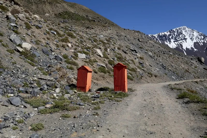
- Toilet Etiquette: Use the toilets at the Welcome Centre or Refugio Chileno. If you are caught short on the trail, move at least 60 metres from water sources, dig a small hole, and pack out your toilet paper in a sealed bag.