Torq La Pass Trek - The Roof of the World
The Torq La Pass Trek is a formidable high-altitude journey through the heart of the Gorno-Badakhshan Autonomous Region (GBAO) in Tajikistan. Spanning approximately 65 kilometres, this 5-to-7-day expedition traverses the rugged, sun-scorched landscapes of the Pamir Mountains—a region often referred to as the "Roof of the World." Unlike the more manicured trails of Europe or North America, the Torq La route is a raw, wilderness experience that demands self-sufficiency, physical resilience, and a deep respect for the unpredictable nature of high-alpine environments. Starting from the traditional Pamiri village of Pastkhuf in the Gunt Valley, the trail ascends through narrow river canyons, across vast glacial moraines, and over the towering Torq La Pass, which sits at an elevation exceeding 4,700 metres. This is a trek for those seeking profound solitude, where the only companions are the whistling wind, the occasional ibex, and the legendary hospitality of the Pamiri people.
- Distance: 65.0 km point-to-point
- Duration: 5–7 days
- Season: July to September (optimal window for snow-free passes)
- Elevation Gain: 3,800 m total ascent
- Highest Point: Torq La Pass (approx. 4,720 m)
- Difficulty: Challenging (requires high-altitude experience and navigation skills)
- Closest City: Khorog, Tajikistan
- Accommodation: Wild camping and limited village homestays
Overview
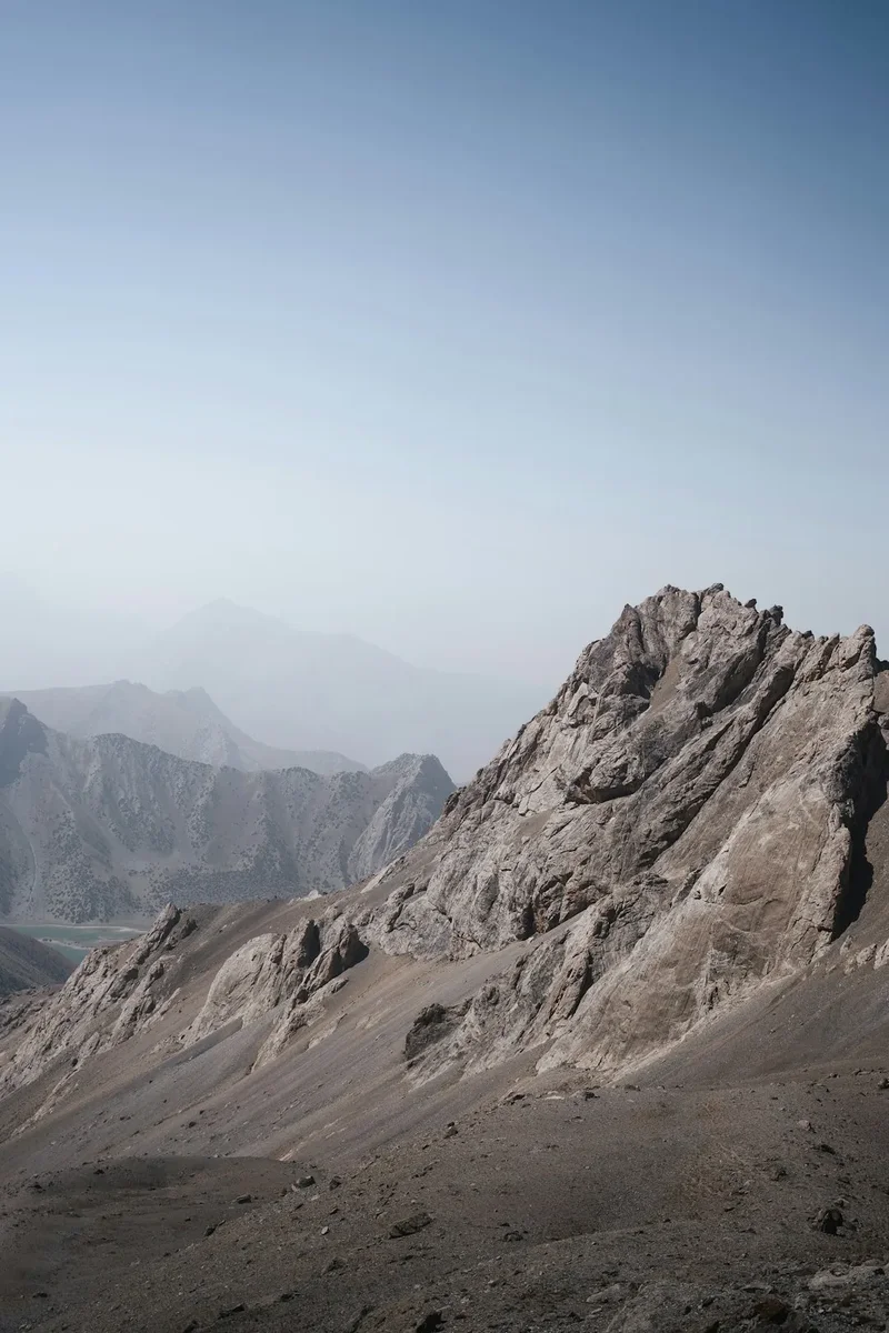
The Torq La Pass Trek offers a masterclass in geological drama and cultural immersion. The journey begins in the Gunt Valley, where the greenery of irrigated village orchards provides a stark contrast to the towering, arid peaks that hem in the valley. As you leave the village of Pastkhuf, the landscape undergoes a rapid transformation. The lush apricot and walnut groves give way to hardy alpine scrub, which eventually disappears entirely, replaced by a lunar landscape of shattered granite, turquoise glacial lakes, and permanent snowfields. The scale of the Pamirs is difficult to articulate; the mountains here do not merely rise—they dominate the horizon in every direction, their jagged summits often exceeding 5,000 or 6,000 metres.
Physically, the trek is a test of endurance. The elevation gain is significant, and the thin air at 4,000 metres makes every step feel twice as heavy. The ascent to the Torq La Pass itself involves navigating steep scree slopes and potentially crossing late-season snow patches. However, the reward for this exertion is unparalleled. From the summit of the pass, the panorama stretches across the central Pamir plateau, revealing a sea of peaks that seem to ripple toward the horizon. The descent leads into remote valleys where the silence is absolute, broken only by the roar of glacial meltwater rivers. This is one of the few places on Earth where a trekker can walk for days without encountering another soul, offering a level of wilderness immersion that is increasingly rare in the modern world.
Culturally, the trek provides a window into the unique lives of the Pamiri people. The inhabitants of the Gunt Valley are primarily Ismaili Muslims, followers of the Aga Khan, and their culture is defined by a blend of ancient Persian traditions and mountain resilience. Their hospitality is legendary; it is not uncommon for a passing trekker to be invited into a traditional Pamiri house (a "Chid") for tea, bread, and homemade yogurt. These encounters provide a vital human connection in an otherwise desolate landscape, reminding travellers that even in the harshest environments, warmth and community flourish. The Torq La Pass Trek is not just a physical journey; it is a spiritual and cultural odyssey through one of the most remote corners of Central Asia.
History and Cultural Context
The history of the Pamir Mountains is inextricably linked to the Silk Road, the ancient network of trade routes that connected China with the Mediterranean. While the main branches of the Silk Road often skirted the highest peaks, the valleys surrounding the Torq La Pass served as vital corridors for local traders, pilgrims, and explorers for millennia. These high passes were the only way to move livestock and goods between the isolated valleys of the GBAO, and the paths used by modern trekkers are often the same trails carved out by generations of Pamiri shepherds.
In the 19th century, the region became a focal point of the "Great Game," the strategic rivalry between the British and Russian Empires for supremacy in Central Asia. Explorers and spies from both empires ventured into these mountains, mapping the passes and documenting the cultures of the high Pamirs. The Torq La Pass itself would have been a known, albeit difficult, crossing for those attempting to move between the Gunt Valley and the high plateaus of the Murghab district. During the Soviet era, the region saw significant infrastructure development, including the construction of the Pamir Highway (M41), but the interior valleys remained largely untouched, preserved as a bastion of traditional mountain life.
The cultural heart of the trek lies in the Pamiri "Chid." These traditional houses are architectural marvels designed with deep symbolic meaning. Each of the five main pillars represents a significant figure in Ismaili history, and the skylight (the "Ruzn") is composed of four concentric squares representing the elements of earth, water, air, and fire. Understanding this symbolism transforms a simple stay in a village homestay into a profound cultural experience. The Pamiri people have survived centuries of isolation and political upheaval by maintaining a strong sense of community and a deep connection to their land. As you trek over the Torq La, you are walking through a landscape that is not just a natural wonder, but a living museum of human endurance and faith.
Want more background? Read extended notes on history and cultural context → Learn more
Seasonal Highlights and Weather Reality
The trekking season in the Pamirs is short and intense, dictated by the arrival and departure of the winter snows. For the Torq La Pass Trek, the window of opportunity is generally limited to the months of July, August, and September. Outside of this period, the high passes are choked with snow, and the risk of avalanches makes the route impassable for all but the most experienced winter mountaineers.
July and August: This is the peak trekking season. The weather is generally stable, with clear blue skies and intense sunshine. Daytime temperatures in the valleys can reach 25°C to 30°C, but as you ascend, the temperature drops significantly. At high camps above 4,000 metres, night-time temperatures frequently dip below freezing, even in the height of summer. This is also the time when the glacial melt is at its peak, making river crossings more challenging. The wildflowers in the lower meadows are in full bloom during July, providing splashes of colour against the grey granite.
September: Early September is often considered the "golden window" for trekking. The summer heat has dissipated, the river levels have dropped, making crossings easier, and the air is exceptionally clear. However, the days are shorter, and the risk of early-season snowstorms increases. By late September, the "buran" (high-altitude storms) can arrive without warning, bringing sub-zero temperatures and heavy snowfall that can obscure the trail and make navigation difficult.
Weather Reality: Regardless of the month, weather in the Pamirs is notoriously unpredictable. A perfectly clear morning can transform into a violent thunderstorm by mid-afternoon. High-altitude winds can be fierce, especially on the Torq La Pass itself. Trekkers must be prepared for four seasons in a single day, carrying gear that can handle both blistering sun and freezing sleet. Radiation is also a serious concern; the thin atmosphere provides little protection from UV rays, making high-quality sun protection essential.
Recommended Itinerary
6-Day Torq La Pass Trek Itinerary
Day 1: Pastkhuf Village to River Camp
- Distance: 12 km
- Elevation gain: 800 m
- Time: 5–6 hours
- Start in the village of Pastkhuf (2,500 m) after a final Pamiri breakfast
- Follow the Pastkhuf River upstream through a narrow, dramatic canyon
- The trail is well-defined but rocky, passing through small groves of willow and sea buckthorn
- Set up camp near the river at approximately 3,300 m
- This day is crucial for acclimatisation; keep a slow, steady pace and drink plenty of water
Day 2: River Camp to High Base Camp
- Distance: 10 km
- Elevation gain: 700 m
- Time: 4–5 hours
- The valley opens up, revealing the high peaks of the central Pamirs
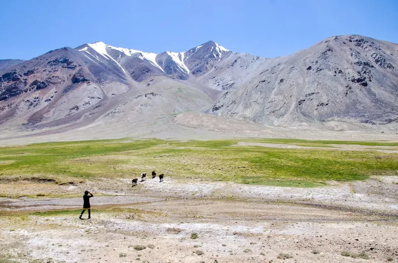
- Ascend through alpine meadows where you may encounter nomadic shepherds and their flocks of fat-tailed sheep
- The terrain becomes increasingly barren as you approach the tree line
- Establish High Base Camp at approximately 4,000 m, situated near a small glacial stream
- Spend the afternoon resting and preparing for the pass crossing the following day
Day 3: High Base Camp to Torq La Pass and Descent
- Distance: 14 km
- Elevation: 720 m gain to pass, 600 m descent
- Time: 7–9 hours
- The most challenging day of the trek. An early start (06:00) is essential to ensure stable snow conditions and clear weather
- The ascent to Torq La Pass (4,720 m) involves navigating steep scree and potentially crossing permanent snowfields
- The final 200 metres are particularly steep and require careful footwork
- Summit the pass for breathtaking 360-degree views of the Pamir range
- Descend into the adjacent valley, following a steep, rocky path toward a series of turquoise glacial lakes
- Camp near the lakes at 4,120 m
Day 4: Glacial Lakes to Upper Valley Camp
- Distance: 12 km
- Elevation: 400 m descent
- Time: 5–6 hours
- A spectacular day of trekking through a high-altitude wilderness
- The trail skirts several large lakes, their colours shifting from emerald to deep sapphire depending on the light
- The terrain is a mix of boulder fields and soft alpine tundra
- Keep an eye out for marmots and the elusive Siberian ibex on the surrounding cliffs
- Camp in the upper reaches of the new valley system at 3,700 m
Day 5: Upper Valley Camp to Bachor Village
- Distance: 17 km
- Elevation: 400 m descent
- Time: 6–7 hours
- A long but mostly downhill day as you follow the river toward the village of Bachor
- The landscape gradually becomes greener as you descend
- Pass through several summer pastures (jailoos) where locals graze their yaks
- The final approach to Bachor involves a series of switchbacks down to the Gunt River
- Arrive in Bachor (3,300 m) and settle into a local homestay for a well-earned celebration
Day 6: Bachor Exploration and Return to Khorog
- Distance: N/A
- Time: 3–4 hours (drive)
- Spend the morning exploring the traditional architecture and irrigation systems of Bachor
- Visit the local hot springs if time permits
- Meet your 4x4 transport for the rugged drive back along the Pamir Highway to Khorog
- Reflect on the journey over a final dinner in the regional capital
Important Notes:
- This itinerary is flexible; fit groups may complete it in 5 days, while those struggling with altitude should allow 7 days
- Water sources are generally plentiful but must be treated
- Navigation can be difficult in poor visibility; a GPS and topographic maps are mandatory
- There are no rescue services in this region; self-sufficiency is paramount
Planning and Bookings
Book Your Trip
Everything you need to plan your journey
Accommodation
Find places to stay near Khorog
Flights
Search flights to Khorog
Essential Preparation
Planning a trek in the Pamirs requires a level of logistical coordination far beyond a standard mountain hike. The primary hub for all preparations is the city of Khorog. Here, you must finalise your supplies, arrange transport, and ensure all permits are in order. Physical fitness is non-negotiable; you should be comfortable carrying a 15–20 kg pack for 6–8 hours a day at altitudes above 3,000 metres. Training should focus on cardiovascular endurance and leg strength, ideally with weighted pack hikes in the months leading up to the trip.
Acclimatisation is the single most important factor for success. It is highly recommended to spend at least 3–4 days in Khorog (2,100 m) or the surrounding valleys before starting the trek. Many trekkers choose to visit the Wakhan Valley or Jizeu first to help their bodies adjust to the elevation. Coordination with a local driver is essential, as the trailheads at Pastkhuf and Bachor are only accessible via 4x4 vehicles. These can be organised through the Pamir Eco-Cultural Tourism Association (PECTA) office in Khorog.
Trail Accommodation
Accommodation on the Torq La Pass Trek is a mix of wild camping and traditional village homestays. There are no mountain huts or established campsites with facilities along the route.
Wild Camping: For the majority of the trek, you will be camping in the wilderness. You must bring a high-quality, four-season tent capable of withstanding high winds and potential snow. Campsites should be chosen near water sources, but at least 30 metres away from the water's edge to prevent contamination. There are no fees for wild camping in this region.
Village Homestays: In Pastkhuf and Bachor, you can stay in traditional Pamiri homestays. These provide a unique cultural experience and a comfortable bed before and after the trek.
- Facilities: Typically include a shared sleeping area on raised platforms (kurpachas), basic pit toilets, and sometimes a simple "Banya" (sauna) for washing.
- Meals: Homestays provide breakfast and dinner, usually consisting of bread, tea, soup, and dairy products.
- Cost: Approximately US$20–$30 per night, including meals. Cash (Tajik Somoni) is the only accepted currency.
- Booking: While some can be booked via PECTA, many operate on a walk-in basis. In the peak season, arriving early in the afternoon is advised.
Required Gear
- Footwear: Sturdy, waterproof trekking boots with excellent ankle support. Ensure they are well broken-in to avoid blisters in remote areas.
- Backpack: A 60–75L internal frame pack with a high-quality harness system. A waterproof pack cover is essential.
- Clothing: A layering system is vital. Include merino wool base layers, a fleece or down mid-layer, and a high-quality Gore-Tex outer shell (jacket and trousers).
- Sleeping System: A four-season sleeping bag with a comfort rating of at least -10°C. A high-R-value sleeping mat is necessary to insulate against the cold ground.
- Navigation: A GPS device with offline maps, a compass, and paper topographic maps (1:50,000 scale if available).
- Safety Gear: A comprehensive first aid kit, including altitude sickness medication (Diamox), a multi-tool, and a satellite communication device (e.g., Garmin inReach), as there is no mobile signal.
What to Bring
- Food: You must carry all food for the duration of the trek. Focus on high-calorie, lightweight options: dehydrated meals, nuts, dried fruit, chocolate, and instant coffee/tea. Supplies in Khorog are limited, so consider bringing specialised trekking food from home.
- Water Treatment: A reliable water filter (e.g., Sawyer Squeeze) or purification tablets. While mountain water looks clear, livestock grazing means it must be treated.
- Cooking: A multi-fuel stove is recommended, as canisters can be hard to find in Khorog (though PECTA often has them). Bring enough fuel for 7 days, accounting for the extra time needed to boil water at high altitudes.
- Personal Items: Biodegradable soap, wet wipes (for "showering"), high-SPF sunscreen, lip balm with SPF, and a wide-brimmed hat.
- Power: A large capacity power bank (20,000mAh+) and a portable solar charger to keep electronics functioning in the cold.
Permits

The Torq La Pass Trek is located within the Gorno-Badakhshan Autonomous Region (GBAO), which requires a special permit in addition to a standard Tajik visa. This is not a "trekking permit" in the traditional sense, but a regional security clearance that is checked at numerous military checkpoints along the Pamir Highway.
GBAO Permit Requirements:
- The permit can be applied for simultaneously with your E-Visa online. Ensure you check the "GBAO Permit" box during the application process.
- If you are entering Tajikistan on a visa-free regime, you must obtain the GBAO permit at the OVIR office in Dushanbe. This usually takes 1–2 working days.
- The permit lists specific districts. Ensure "Khorog," "Shughnan," and "Rushon" are included for this trek.
- Always carry multiple photocopies of your passport and GBAO permit. Checkpoint officers will often ask for a "pervusk" (copy) to keep for their records.
National Park Fees: Parts of the trek may fall within the Tajik National Park (a UNESCO World Heritage site). While enforcement is sporadic in remote valleys, you should be prepared to pay a small daily fee (approx. 15–20 Somoni) if you encounter a park ranger. Keep all receipts.
Border Zone Permits: Because the trek is relatively close to the Afghan border, some routes may technically require an additional "Border Zone Permit." While the Torq La route usually does not, it is wise to check the current security situation at the PECTA office in Khorog before departing. They provide the most up-to-date information on which valleys are currently restricted.
Other Activities in the Area
The Pamirs offer a wealth of experiences for those with extra time in the region:
- The Pamir Highway (M41): Embark on one of the world's greatest road trips, crossing high-altitude passes and traversing the desolate Murghab plateau.
- Wakhan Valley: Explore the ancient silk road fortresses (like Yamchun) and soak in the Bibi Fatima hot springs while looking across the river into Afghanistan.
- Jizeu Valley: A shorter, 2-day trek to a remote village with no road access, famous for its stunning lakes and traditional lifestyle.
- Khorog Botanical Garden: One of the highest botanical gardens in the world, offering great views over the city and a peaceful place to recover after your trek.
- Bulunkul and Yashilkul Lakes: Visit the coldest place in Tajikistan and witness the stunning "Green Lake" on the high plateau.
- Engels Peak Base Camp: For those seeking more high-altitude trekking, the route to the base of the 6,510 m Peak Engels offers spectacular glacial views.
Safety and Conditions
Altitude Sickness (AMS): This is the primary safety concern on the Torq La Pass Trek. With the pass exceeding 4,700 metres, Acute Mountain Sickness is a genuine risk. Symptoms include headache, nausea, dizziness, and fatigue. The only cure for AMS is descent. Trekkers should follow the "climb high, sleep low" principle and be aware of the signs of HAPE (High Altitude Pulmonary Edema) and HACE (High Altitude Cerebral Edema), both of which are life-threatening emergencies. Carry Diamox and know how to use it, but never use it to mask symptoms while continuing to ascend.
River Crossings: Glacial meltwater rivers can be dangerous, especially in the afternoon when flow is highest. Cross rivers in the early morning when possible. Use trekking poles for stability, unclip your backpack's waist belt, and cross at the widest, shallowest point. If a crossing looks too deep or fast, wait or find an alternative route; the water is glacially cold and can cause hypothermia within minutes.
Remote Location: There is no mountain rescue service in Tajikistan. In the event of a serious injury, you are responsible for your own evacuation. This usually involves being carried by horse or fellow trekkers to the nearest road, which could be days away. A satellite communication device is essential for contacting your insurance provider to arrange a private helicopter (which must often come from Dushanbe or even Kyrgyzstan). Ensure your travel insurance specifically covers "trekking up to 5,000 metres."
Wildlife and Environment: While attacks are unheard of, the Pamirs are home to wolves and bears. Store food securely away from your tent. The environment is extremely fragile; the high-altitude sun is intense, and the wind can cause rapid dehydration. Drink at least 4–5 litres of water per day and use high-quality sun protection.
Side Trips and Points of Interest
The Lakes of Torq La: On the descent from the pass, you will encounter a series of unnamed glacial lakes. These are perfect spots for a "rest day" if your itinerary allows. The water is too cold for swimming, but the reflections of the surrounding peaks in the still morning air are a photographer's dream. The geology here is fascinating, with clear evidence of recent glacial retreat and massive moraine walls.
Petroglyphs: In several locations along the Gunt Valley and its tributaries, ancient petroglyphs can be found carved into the dark "desert varnish" of the rocks. These carvings, some dating back to the Bronze Age, depict ibex, hunters, and solar symbols. Finding them requires a keen eye and often a bit of scrambling off the main trail, but they serve as a powerful reminder of the long history of human presence in these mountains.
Summer Pastures (Jailoos): If trekking in July or August, you will likely pass through high-altitude pastures where Pamiri families spend the summer months. These temporary settlements of small stone huts or yurts are centres of traditional dairy production. Visiting a jailoo is a highlight of the trek; you may be offered "Qurut" (dried yogurt balls) or fresh yak milk. It is polite to offer a small gift or a few Somoni in exchange for hospitality.
Leave No Trace
The Pamir Mountains are a pristine but highly sensitive ecosystem. The combination of high altitude, low temperatures, and aridity means that organic waste takes decades to decompose, and physical scars on the landscape can last for centuries. As tourism increases in Tajikistan, the responsibility of every trekker to minimise their impact becomes even more critical.
Leave No Trace Principles for the Pamirs:
- Waste Management: Pack out absolutely everything. This includes "micro-trash" like fruit stickers and tea bag tags. Since there are no waste disposal facilities in the villages, carry your trash back to Khorog.
- Human Waste: Use a "cathole" at least 15–20 cm deep and at least 60 metres from any water source. In the high, rocky areas where digging is impossible, you must carry out your toilet paper in a sealed bag.
- Campfire Policy: Do not build campfires. Wood is an extremely scarce and valuable resource for local people in these high valleys. Use a camping stove for all cooking.
- Respecting Culture: Always ask permission before taking photos of people or their homes. Dress modestly when passing through villages (shoulders and knees covered).
- Protecting Water: Do not use soap or detergent directly in streams or lakes. Even biodegradable soap can harm sensitive aquatic life in these nutrient-poor waters. Carry water 30 metres away from the source for washing.