Tonquin Valley Trail - The Heart of the Canadian Rockies
The Tonquin Valley Trail is widely considered the crown jewel of Jasper National Park, offering a quintessential Canadian Rockies experience that combines immense geological scale with pristine subalpine wilderness. Stretching approximately 45 kilometres through the McCarib and Astoria passes, this multi-day journey leads hikers into a high-altitude sanctuary dominated by the Ramparts—a staggering 1,000-metre wall of quartzite peaks that rise vertically from the shores of Amethyst Lake. Unlike many other popular trails in the region, the Tonquin Valley provides a profound sense of isolation, where the silence is broken only by the whistle of hoary marmots or the distant thunder of calving glaciers. It is a landscape of extremes: delicate alpine meadows carpeted in wildflowers, treacherous mud-choked valleys, and some of the most dramatic mountain scenery on the North American continent. For those seeking to witness the raw, unedited power of the Rockies, the Tonquin Valley is an essential pilgrimage.
- Distance: 45.0 km (point-to-point or partial loop)
- Duration: 3–5 days
- Elevation Gain: 820 m
- Difficulty: Moderate (challenging due to mud and insects)
- Best Time: July to September (August is optimal for lower bug counts)
- Highest Point: Maccarib Pass (2,210 m)
- Closest City: Jasper, Alberta
- Trailhead Access: Portal Creek (Hwy 93A) or Astoria (Cavell Road)
Overview
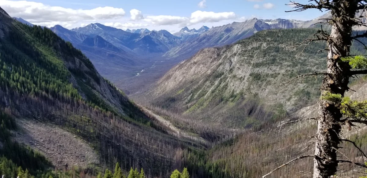
The Tonquin Valley is a high-altitude basin that sits at the intersection of several major mountain ranges within the Jasper backcountry. Its reputation is built primarily on the visual impact of the Ramparts, a jagged semi-circle of peaks including Mount Geikie, Turret Mountain, and Barbican Peak. These mountains do not merely border the valley; they loom over it, creating a vertical backdrop that reflects perfectly in the turquoise waters of Amethyst Lake. The trail itself is a journey of transition, moving from the dense lodgepole pine and Douglas fir forests of the lower valleys into the expansive, wind-swept meadows of the alpine zone. Because the valley floor sits at a relatively high elevation (approximately 1,900 to 2,000 metres), hikers spend a significant portion of their trip above the treeline, enjoying unobstructed views that stretch for kilometres in every direction.
While the scenery is world-class, the Tonquin Valley is also famous among the hiking community for its physical demands—specifically its mud and its mosquitoes. The valley is a massive drainage basin, and even in the height of summer, sections of the trail can remain boggy and saturated. This requires a certain level of mental fortitude and high-quality waterproof footwear. Furthermore, the valley is a critical habitat for the Southern Mountain Caribou, one of the most endangered species in the Canadian Rockies. To protect this fragile population, Parks Canada strictly regulates access, particularly during the winter and early spring. Walking here is a privilege that comes with the responsibility of being a silent observer in a highly sensitive ecological zone. The reward for navigating the mud and the bugs is an encounter with a landscape that feels ancient and untouched, a place where the scale of the mountains makes human concerns feel delightfully insignificant.
The route is typically completed as a point-to-point hike, starting at the Portal Creek trailhead and finishing at the Astoria trailhead (or vice versa). This requires a vehicle shuttle or a pre-arranged transport plan. Alternatively, some hikers choose to enter and exit via the same trailhead, though this misses the varied scenery of the two distinct passes. Regardless of the chosen direction, the Tonquin Valley demands respect for its weather, its wildlife, and its rugged terrain.
History and Cultural Context
The human history of the Tonquin Valley is as layered as the sedimentary rock of the Ramparts. For millennia, the area was part of the traditional territories of the Stoney Nakoda, Secwépemc, and Upper Athabasca Valley Métis peoples. These Indigenous groups utilised the high passes for travel, hunting, and gathering, maintaining a deep spiritual and practical connection to the land long before the arrival of European explorers. The valley was a source of sustenance and a vital corridor through the formidable barrier of the Continental Divide.
The valley's modern name is derived from the "Tonquin," a ship owned by the Pacific Fur Company that was destroyed off the coast of Vancouver Island in 1811. The naming reflects the era of the fur trade, when the North West Company and the Hudson’s Bay Company were competing to find efficient routes through the mountains to the Pacific. However, the Tonquin Valley itself remained largely "undiscovered" by the Western world until the early 20th century. It was the legendary explorer and botanist Mary Schäffer Warren who, in 1911, helped bring international attention to the region. Her descriptions of the "indescribable beauty" of the Ramparts and Amethyst Lake sparked interest among the burgeoning mountaineering community.
In 1915, the legendary surveyor Morrison Bridgland mapped the area in detail, providing the first comprehensive look at the valley's topography. The Ramparts were named by members of the Alpine Club of Canada, who saw in the sheer quartzite walls a resemblance to the defensive fortifications of a medieval fortress. Since then, the valley has become a focal point for conservation efforts. The establishment of Jasper National Park in 1907 provided the framework for protection, but it was the later recognition of the valley as critical caribou habitat that led to the modern, highly regulated management style seen today. Every step taken on the trail is a step through a landscape that has been fought for by conservationists and cherished by generations of mountain lovers.
Want more background? Read extended notes on history and cultural context → Learn more
Seasonal Highlights and Weather Reality
The window for hiking the Tonquin Valley is remarkably short due to its high elevation and northern latitude. Snow can linger on Maccarib Pass well into July, and the first autumn blizzards often arrive by mid-September. Understanding the nuances of these few months is critical for a successful trip.
July: This is the month of the great awakening. As the snow melts, the alpine meadows erupt in a carpet of wildflowers, including western anemone, Indian paintbrush, and heather. However, July is also the peak of "bug season." The standing water in the valley floor provides a perfect breeding ground for mosquitoes and blackflies, which can be relentless. Hikers in July must be prepared with full bug jackets and high-concentration repellent. Trail conditions are often at their muddiest during this time as the ground thaws and snowmelt drains through the valley.
August: Generally considered the prime month for the Tonquin Valley. The insect population begins to decline (though they never truly disappear), and the trail starts to dry out, making the boggy sections more manageable. The weather is typically more stable, with warm days and cool nights, though afternoon thunderstorms are common. This is the busiest time for the trail, and backcountry campsites will be at full capacity.
September: For many experienced hikers, September is the best time to visit. The mosquitoes are gone, and the subalpine larch trees and dwarf birch turn brilliant shades of gold and orange. The air is crisp and clear, providing the best visibility for photography. However, the risk of snow increases significantly. Temperatures frequently drop well below freezing at night, and hikers must be prepared for full winter conditions at any moment. By late September, many of the seasonal bridges may be removed, and the trail officially enters its winter closure period to protect the caribou.
Winter and Spring: The Tonquin Valley is closed to all human access from November 1st to May 15th (and often later depending on snow conditions) to prevent the disturbance of the endangered Southern Mountain Caribou during their most vulnerable season. There is no winter trekking or skiing permitted in the main valley basin.
Recommended Itinerary
4-Day Tonquin Valley Itinerary (Portal Creek to Astoria)
Day 1: Portal Creek Trailhead to Maccarib Campground
- Distance: 19.5 km
- Elevation gain: 650 m
- Time: 6–8 hours
- Start at the Portal Creek trailhead on Highway 93A
- Steady climb through forest alongside Portal Creek
- Cross the "Circus," a dramatic rock-filled cirque below Porthole Mountain
- Ascend to the crest of Maccarib Pass (2,210 m) for your first view of the Ramparts
- Descend into the wide, open meadows of the Maccarib Valley
- Arrive at Maccarib Campground, situated near a small creek with views of the distant peaks
- This is a long opening day; an early start is essential to reach camp before late afternoon storms
Day 2: Maccarib Campground to Amethyst Lake or Surprise Point
- Distance: 5–8 km (depending on campsite)
- Elevation gain: Minimal (mostly flat or slight descent)
- Time: 2–3 hours
- A shorter day designed to allow maximum time at the shores of Amethyst Lake
- Walk through the expansive Maccarib Meadows, keeping an eye out for caribou and grizzly bears
- Pass the Tonquin Valley backcountry lodges
- Arrive at Amethyst Lake Campground (located on the northern shore) or continue to Surprise Point Campground (located at the southern end)
- Spend the afternoon exploring the lakeshore, photographing the Ramparts, or relaxing by the water
- The reflection of the mountains in the lake at sunset is the highlight of the entire trip
Day 3: Exploration and Side Trips
- Distance: Variable (8–12 km recommended)
- Elevation gain: 200–400 m
- Time: 4–6 hours
- Use Amethyst Lake or Surprise Point as a base camp
- Recommended side trip: Hike toward the Eremite Valley for a closer look at the glaciers and hidden tarns
- Alternative: Walk the shoreline of Amethyst Lake toward the base of the Ramparts
- Observe the unique geology of the quartzite cliffs and the massive talus slopes
- Return to the same campground for a second night under the stars
- This "rest" day is crucial for soaking in the atmosphere of the valley without the weight of a full pack
Day 4: Amethyst Lake to Astoria Trailhead
- Distance: 20 km
- Elevation: 150 m gain, 750 m descent
- Time: 6–8 hours
- Depart the lake and head south toward the Astoria River valley
- Pass through the "Switchbacks," a series of steep descents that drop you from the alpine zone into the forest
- Follow the Astoria River through dense forest and over several bridges
- Pass the junction for the Wates-Gibson Hut
- Final stretch along a wide, relatively flat trail to the Astoria trailhead near Edith Cavell
- Arrange for a shuttle or second vehicle to return to the Portal Creek start point
Important Notes:
- The trail can be hiked in either direction, but starting at Portal Creek offers a more gradual ascent to the high pass
- Campsites must be booked months in advance via the Parks Canada reservation system
- Be prepared for significant mud between Maccarib Pass and Amethyst Lake
- Water is abundant along the entire route but must be treated
- Bear lockers are provided at all designated campgrounds; use them for all attractants
Planning and Bookings
Book Your Trip
Everything you need to plan your journey
Accommodation
Find places to stay near Jasper
Flights
Search flights to Jasper
Essential Preparation
The Tonquin Valley is a remote backcountry destination that requires significant physical preparation and logistical planning. Hikers should be in good cardiovascular condition, as the first and last days involve long distances with heavy packs. Because the trail is point-to-point, you must organise transport between the Portal Creek and Astoria trailheads. These are approximately 20 kilometres apart by road. Most hikers either use two vehicles or book a private shuttle service in Jasper. There is no public transport to the trailheads.
Before leaving Jasper, check the latest trail reports at the Parks Canada Information Centre. They provide updates on bridge washouts, bear activity, and snow levels on the passes. Ensure you have a valid Parks Canada Discovery Pass for your vehicle and that your backcountry permit is printed and accessible. Jasper townsite is your last chance for supplies; it has several well-equipped outdoor stores and supermarkets, but prices are higher than in major cities like Edmonton.
Trail Accommodation
Accommodation in the Tonquin Valley consists of Parks Canada backcountry campgrounds and two privately operated lodges. There are no random camping zones; you must stay at the site designated on your permit.
Backcountry Campgrounds: The primary campgrounds are Portal Creek, Maccarib, Amethyst Lake, Surprise Point, Clitheroe, and Astoria. Each site typically includes:
- Designated tent pads (usually dirt or wooden platforms)
- Shared cooking areas with picnic tables
- Heavy-duty bear lockers or bear poles for food storage
- Pit toilets (bring your own toilet paper)
- A nearby water source (creek or lake)
- Cost: Approximately $13.50 per person, per night (plus a reservation fee)
Private Lodges: For those seeking more comfort, Tonquin Valley Adventures and Tonquin Valley Lodge offer rustic cabin accommodation and catered meals. These must be booked directly with the operators and often sell out a year in advance. They provide a "glamping" experience in the heart of the wilderness, including horse-pack services for gear transport.
Wates-Gibson Hut: Operated by the Alpine Club of Canada, this large stone hut is located near Outpost Lake, slightly off the main Astoria River trail. It requires a separate booking through the ACC and offers a communal sleeping area and kitchen facilities.
Required Gear
- Sturdy hiking boots - Must be waterproof and well broken-in. The mud in the Tonquin is legendary and will test any footwear.
- Gaiters - Highly recommended to keep mud and debris out of your boots.
- Backpack - 50–70L capacity with a high-quality rain cover.
- Tent - A lightweight, 3-season backpacking tent with a full fly and a footprint to protect against damp ground.
- Sleeping bag - Rated to at least -5°C. Even in August, frost is common in the alpine meadows.
- Sleeping pad - Insulated pad to protect against the cold ground.
- Bear spray - Essential and must be carried in an accessible holster (not inside your pack).
- Navigation - Topographic map (NTS 83D/9 and 83D/16) and a compass or GPS.
- Multi-tool or knife - For gear repairs and food prep.
What to Bring
- Food - Lightweight, high-calorie dehydrated meals for the duration of the trip, plus one extra day of emergency rations.
- Water treatment - A high-quality filter (hollow fibre or ceramic) or chemical purification drops. The water may contain Giardia.
- Bug protection - A head net is almost mandatory in July and early August. Bring high-DEET or Picaridin repellent.
- Clothing layers - Merino wool or synthetic base layers, a fleece or down mid-layer, and a high-quality waterproof/breathable shell jacket and trousers.
- Sun protection - SPF 50+ sunscreen, polarized sunglasses, and a wide-brimmed hat. The alpine sun is intense.
- First aid kit - Including blister treatment (moleskin/Leukotape), antiseptic wipes, and any personal medications.
- Stove and fuel - Lightweight canister or liquid fuel stove. No fires are permitted in the backcountry.
- Kitchen kit - Lightweight pot, mug, spoon, and a small biodegradable soap for cleaning.
- Power bank - To keep your phone or GPS charged, as there is no electricity in the valley.
Permits
All overnight stays in the Tonquin Valley require a Parks Canada Backcountry Permit. The reservation system typically opens in early to mid-March for the upcoming summer season. Because the Tonquin Valley is one of the most sought-after destinations in the Canadian Rockies, campsites often sell out within minutes of the system going live. It is highly recommended to have your itinerary, preferred dates, and payment information ready the moment the portal opens.
Booking Process:
- Create an account on the Parks Canada Reservation Service website well before the opening date.
- Log in at least 15 minutes before the reservations open (usually 8:00 AM Mountain Time).
- Select "Backcountry" and then "Jasper" as the park.
- Choose your entry and exit points (Portal Creek or Astoria).
- Be flexible with your dates; if your first choice is gone, have a backup plan ready.
Costs and Regulations:
- Backcountry Camping Fee: $13.50 per person, per night.
- Reservation Fee: Approximately $11.50 per booking (non-refundable).
- National Park Entry Fee: You must also possess a valid Discovery Pass or daily entry pass for Jasper National Park.
- Maximum Group Size: 10 people per permit.
- Maximum Stay: 3 nights at any single campground.
Cancellations: If you cannot make your trip, please cancel your reservation as early as possible. This allows other hikers to access the valley and helps Parks Canada manage the high demand. Refunds are available minus the reservation and cancellation fees, provided you cancel at least 3 days before your start date.
Other Activities in the Area
Jasper National Park is a vast wilderness with endless opportunities for exploration. If you have extra time before or after your Tonquin Valley trek, consider these activities:
- Mount Edith Cavell: Located near the Astoria trailhead, this area offers stunning views of the Angel Glacier and the Path of the Glacier trail. It is one of the most accessible alpine environments in the park.
- Maligne Lake: Take a boat cruise to Spirit Island, one of the most photographed spots in Canada, or hike the Skyline Trail for more high-altitude vistas.
- Miette Hot Springs: The hottest springs in the Canadian Rockies are the perfect way to soothe sore muscles after 45 kilometres of hiking.
- Jasper SkyTram: For those who want the views without the climb, the SkyTram takes you to the summit of Whistlers Mountain for a 360-degree panorama of the Fryatt Range and the townsite.
- Wildlife Tours: Jasper is famous for its elk, bears, and bighorn sheep. Several local operators offer guided tours that increase your chances of seeing these animals safely.
- Stargazing: Jasper is a designated Dark Sky Preserve. On a clear night, the Milky Way is visible with incredible clarity from almost anywhere in the park.
Safety and Conditions
Wildlife Safety: The Tonquin Valley is prime Grizzly and Black Bear habitat. You are walking through their home. Always carry bear spray in an easy-to-reach location and know how to use it. Make noise while hiking, especially in dense brush or near rushing water, to avoid surprising a bear. Store all food, toiletries, and trash in the provided bear lockers at all times. Never eat inside your tent. Additionally, be respectful of the caribou; if you see them, keep a distance of at least 100 metres and do not approach them for photos.
Weather Hazards: Weather in the Rockies is notoriously unpredictable. Even in August, a sunny morning can turn into a freezing sleet storm by afternoon. Hypothermia is a genuine risk. Always carry a full set of waterproof layers and an insulating mid-layer, regardless of the forecast. If lightning begins while you are on Maccarib Pass, descend to a lower elevation immediately and avoid standing near isolated trees or high points.
Water and Health: All water in the backcountry must be treated. While the streams look pristine, they can carry Giardia lamblia (beaver fever), which causes severe gastrointestinal distress. Use a filter, UV purifier, or boiling method. Blisters are the most common injury on this trail due to the wet conditions; treat "hot spots" immediately with moleskin or tape before they become full blisters.
Emergency Communication: There is no mobile phone reception in the Tonquin Valley. It is highly recommended to carry a satellite communication device (such as a Garmin inReach or Zoleo) for emergencies. Ensure someone at home knows your itinerary and your expected return time. If an injury occurs, stay with the injured person and use your satellite device to contact Jasper Park Dispatch.
Side Trips and Points of Interest
The Eremite Valley: This is the most popular side trip from the Amethyst Lake area. Following the trail south from Surprise Point, you enter a narrow, dramatic valley that leads toward the glaciers of the Continental Divide. The scenery here is even more rugged than the main valley, with hanging glaciers and turquoise tarns tucked under the peaks of Mount Erebus and Mount Outpost. It is a 10–12 km return trip from Surprise Point.
Moat Lake: Located at the northern end of the Ramparts, Moat Lake offers a different perspective of the mountain wall. The trail is less defined than the main route, providing a more "off-the-beaten-path" feel. It is an excellent spot for birdwatching and finding solitude away from the main campgrounds.
The Ramparts Shoreline: Simply walking the western shore of Amethyst Lake allows you to stand directly beneath the 1,000-metre cliffs. The scale is difficult to comprehend until you are at the base of the talus slopes. Look for "rock flour"—the fine glacial silt that gives the lake its unique colour—and watch for pikas scurrying among the boulders.
Maccarib Pass Viewpoint: If you have extra energy on Day 1 or Day 4, explore the ridges adjacent to Maccarib Pass. Gaining just 100 metres of elevation above the trail provides a panoramic view that encompasses the entire Tonquin Valley to the west and the Portal Creek drainage to the east.
Leave No Trace
The Tonquin Valley is a fragile subalpine ecosystem that sees thousands of visitors each year. To preserve its beauty and protect its wildlife, all hikers must strictly adhere to Leave No Trace principles. The survival of the Southern Mountain Caribou depends on our ability to minimise our impact on their habitat.
Core Principles for the Tonquin:
- Plan Ahead and Prepare: Know the regulations, carry the right gear, and have a backup plan.
- Travel and Camp on Durable Surfaces: Stay on the established trail, even when it is muddy. Walking around mud puddles widens the trail and destroys fragile alpine vegetation. Use designated tent pads only.
- Dispose of Waste Properly: Pack out everything you pack in, including biodegradable items like orange peels and tea bags. Use the provided pit toilets for human waste.
- Leave What You Find: Do not pick wildflowers or remove rocks and fossils. Leave the landscape as you found it for others to enjoy.
- Minimise Campfire Impacts: Fires are strictly prohibited in the Tonquin Valley backcountry. Use a lightweight stove for all cooking.
- Respect Wildlife: Observe from a distance. Never feed animals, as this habituates them to humans and often leads to the animal being destroyed.
- Be Considerate of Other Visitors: Keep noise levels down and yield to uphill hikers. Let the sounds of nature prevail.