Tongariro Alpine Crossing - New Zealand’s Ultimate Day Hike
The Tongariro Alpine Crossing is widely regarded as the finest one-day trek in New Zealand and frequently ranks among the top ten single-day walks in the world. Spanning 19.4 kilometres across a raw, volcanic landscape in the heart of the North Island, this journey traverses the remarkable terrain of Tongariro National Park—New Zealand’s oldest national park and a dual UNESCO World Heritage site. The track leads walkers through a world of extremes, from cold glacial valleys and ancient lava flows to steaming vents, brilliant turquoise crater lakes, and the imposing silhouettes of three active volcanoes: Mount Tongariro, Mount Ngāuruhoe, and Mount Ruapehu. This is not merely a walk; it is a traverse of a living, breathing geological giant that demands physical endurance and deep respect for the unpredictable forces of nature.
- Distance: 19.4 km point-to-point
- Duration: 7–9 hours
- Elevation Gain: 765 m
- Highest Point: Red Crater (1,886 m)
- Difficulty: Challenging (requires high fitness and alpine preparation)
- Best Time: October to April (Summer season)
- Closest Towns: National Park Village, Whakapapa Village, Turangi, Ohakune
- Status: Dual UNESCO World Heritage Area (Natural and Cultural)
Overview
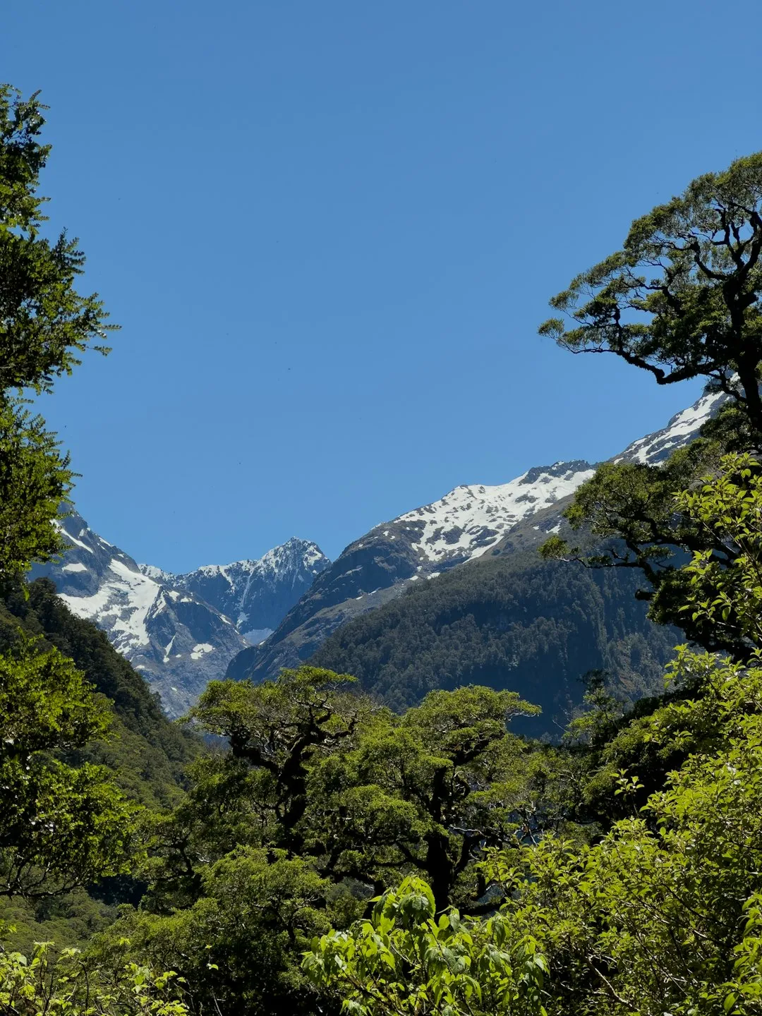
The Tongariro Alpine Crossing offers a sensory experience unlike any other in the Southern Hemisphere. The landscape is defined by its volcanic origins, featuring a stark, "lunar" aesthetic that served as the cinematic backdrop for Mordor in Peter Jackson’s The Lord of the Rings film trilogy. As you ascend from the Mangatepopo Valley, the lush tussock and alpine herbs of the lower slopes give way to a desolate beauty of jagged black basalt, red scoria, and yellow sulphur deposits. The air often carries the faint scent of volcanic gases, a constant reminder that you are walking across an active volcanic zone. The highlight for many is the descent from Red Crater to the Emerald Lakes (Ngā Rotopounamu), where the brilliant green and blue hues of the water—caused by dissolved minerals washed down from the surrounding thermal area—contrast sharply against the dark, barren earth.
The trek is a point-to-point journey, typically walked from the Mangatepopo Valley in the west to the Ketetahi road end in the north. This direction is preferred as it involves less overall climbing (765 m ascent versus 1,125 m descent), though the descent is notoriously taxing on the knees. The weather in this alpine environment is famously volatile; it is not uncommon to experience gale-force winds, freezing temperatures, and torrential rain even in the height of summer. Consequently, the crossing requires a level of preparation far beyond that of a standard coastal or forest walk. Walkers must be self-sufficient, physically capable of sustained uphill movement at altitude, and mentally prepared for the possibility of turning back if conditions deteriorate.
Beyond the geology, the Tongariro Alpine Crossing is a journey through a landscape of immense spiritual significance. To the local iwi (tribe) Ngāti Tūwharetoa, the peaks are ancestors and sacred guardians. The dual World Heritage status recognises not only the exceptional volcanic features but also the cultural links that bind the Māori people to this land. Walking here is a privilege that carries the responsibility of "kaitiakitanga" (guardianship)—protecting the environment and respecting the "tapu" (sacred) nature of the mountain summits, which walkers are asked not to climb.
History and Cultural Context
The history of Tongariro National Park is a story of visionary leadership and profound cultural heritage. In 1887, Te Heuheu Tūkino IV (Horonuku), the paramount chief of Ngāti Tūwharetoa, recognised that the sacred peaks of Tongariro, Ngāuruhoe, and Ruapehu were under threat from private land sales and commercial exploitation. In a move of extraordinary foresight, he gifted the mountain peaks to the people of New Zealand, under the condition that they be protected as a national park. This act created the first national park in New Zealand and the fourth in the world. The gift was intended to ensure that the "mana" (prestige) of the mountains remained intact and that the land would be preserved for all people, forever.
The volcanic history of the area spans hundreds of thousands of years. Mount Tongariro is a complex of multiple volcanic cones, with the most recent significant eruptions occurring at the Te Maari craters in 2012. Mount Ngāuruhoe, the youngest and most active vent in the complex, is a classic stratovolcano that formed approximately 2,500 years ago. Its near-perfect conical shape has made it an icon of the New Zealand landscape. The track itself has evolved from early Māori routes used for traversing the central plateau into a world-class hiking trail, with the Department of Conservation (DOC) continuously working to manage the impact of the hundreds of thousands of visitors who walk the path each year.
In 1993, Tongariro became the first property to be inscribed on the UNESCO World Heritage List under the revised criteria describing "cultural landscapes." This was a landmark moment, acknowledging that the mountains are not just geological curiosities but are central to the identity and spiritual life of the Māori people. The stories of the mountains—such as the battle between the peaks for the love of the beautiful Pīhanga—are still told today, weaving the physical landscape into a rich tapestry of oral history and tradition.
Want more background? Read extended notes on history and cultural context → Learn more
Seasonal Highlights and Weather Reality
The experience of the Tongariro Alpine Crossing changes dramatically with the seasons. During the summer months (late October to April), the track is generally clear of snow, and the vibrant colours of the Emerald Lakes and Red Crater are at their most vivid. This is the peak season when shuttle services operate at full capacity and the track is most accessible to recreational hikers. However, even in summer, the "alpine" designation must be taken seriously. Temperatures at the highest point (1,886 m) can be 10–15 degrees Celsius cooler than at the trailhead, and wind chill can drop the perceived temperature below freezing in an instant.
Autumn (March and April) often brings more stable weather and crisper air, providing exceptional clarity for photography. The crowds begin to thin, though the days become shorter, requiring an earlier start to ensure completion before dusk. Spring (October and November) can be beautiful but is often the most unpredictable season, with lingering snow patches on the high passes and frequent rain as weather systems move across the Tasman Sea.
Winter (May to October) transforms the crossing into a serious mountaineering expedition. The track is covered in deep snow and ice, and the risk of avalanches is a genuine concern in several sections, particularly around the South Crater and the descent from Red Crater. During this time, the crossing should only be attempted by those with alpine skills, including the use of ice axes and crampons. For most visitors, the best way to experience the crossing in winter is by booking a guided trip with a professional alpine guide who can provide the necessary equipment and safety expertise. The Emerald Lakes are often frozen and covered in snow during winter, offering a starkly different, monochromatic beauty compared to the summer months.
Recommended Itinerary
Standard West-to-East Route (Mangatepopo to Ketetahi)
Section 1: Mangatepopo Carpark to Soda Springs
- Distance: 4.4 km
- Time: 1–1.5 hours
- Elevation: Gentle gradient
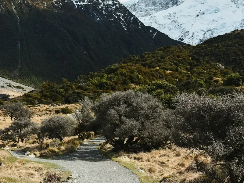
- The journey begins at the Mangatepopo Carpark (1,120 m). The track follows a well-maintained boardwalk and gravel path through the Mangatepopo Valley.
- You will walk alongside a stream and over ancient lava flows covered in hardy alpine shrubs and tussock.
- To your right, the massive form of Mount Ngāuruhoe looms, often shrouded in cloud.
- Soda Springs, a small side trip near the end of this section, features cold springs that create a lush, green oasis against the dark volcanic rock.
Section 2: Soda Springs to South Crater (The Devil's Staircase)
- Distance: 2 km
- Time: 45–60 minutes
- Elevation: 340 m gain
- This is the first major challenge of the day. The "Devil's Staircase" is a steep, stepped climb from 1,400 m to 1,600 m.
- The terrain is composed of scoria and basalt. On a clear day, looking back provides views of Mount Taranaki on the western horizon.
- Take your time here; the altitude begins to affect breathing, and the exposure to wind increases significantly.
Section 3: South Crater to Red Crater
- Distance: 2 km
- Time: 45–60 minutes
- Elevation: 300 m gain
- After catching your breath on the flat expanse of South Crater (which is actually a drainage basin, not a true crater), the track climbs again toward the highest point of the crossing.
- The path follows a narrow ridge with steep drops on either side. This section can be very difficult in high winds.
- The summit of the ridge brings you to the rim of Red Crater (1,886 m), where the vibrant red scoria and the smell of sulphur are intense.
Section 4: Red Crater to Emerald Lakes and Blue Lake
- Distance: 3 km
- Time: 1–1.5 hours
- Elevation: Steep descent on loose scoria
- The descent from Red Crater to the Emerald Lakes is the most photographed part of the track but also the most treacherous for footing. The "scree run" involves sliding down loose volcanic rock.
- The three Emerald Lakes (Ngā Rotopounamu) occupy old explosion craters. Their colour is due to minerals leaching from the thermal area.
- The track then crosses the Central Crater and climbs a short distance to Blue Lake (Te Tikitiki-a-Tarapata), a large, cold acidic lake that is sacred to Māori.
Section 5: Blue Lake to Ketetahi Shelter
- Distance: 3 km
- Time: 1 hour
- Elevation: Steady descent
- The track rounds the flank of North Crater and begins a long, winding descent toward the northern slopes of the mountain.
- You will pass the Ketetahi Springs (private land; stay on the track), where steam vents and hot springs are visible from a distance.
- The Ketetahi Shelter provides a place for a break, though it is no longer an overnight hut due to volcanic risk.
Section 6: Ketetahi Shelter to Ketetahi Carpark
- Distance: 5 km
- Time: 1.5–2 hours
- Elevation: 800 m descent
- The final leg is a long series of zig-zags through golden tussock land, eventually entering a cool, green podocarp forest.
- The change in environment is striking, moving from the barren volcanic heights to the lush bird-filled bush.
- The track ends at the Ketetahi Carpark (750 m), where shuttles wait to transport walkers back to their bases.
Important Notes:
- The track is a one-way traverse; you must arrange transport at both ends.
- There is no drinking water available on the track; you must carry at least 2–3 litres.
- Toilets are located at the start, Soda Springs, South Crater, Blue Lake, and Ketetahi Shelter.
- The total time of 7–9 hours includes breaks and photography.
Planning and Bookings
Book Your Trip
Everything you need to plan your journey
Accommodation
Find places to stay near Ohakune
Flights
Search flights to Ohakune
Essential Preparation
The Tongariro Alpine Crossing is a serious undertaking that requires careful logistical planning. Because it is a point-to-point hike, the most critical element is arranging transport. Most walkers stay in nearby towns such as National Park Village, Whakapapa Village, Turangi, or Ohakune and book a shuttle service. These shuttles typically drop you at the Mangatepopo trailhead in the morning and pick you up from the Ketetahi road end in the afternoon. Booking your shuttle in advance is essential, especially during the summer months (December to February).
Fitness is a major factor. You should be comfortable walking for 8 hours with a 5–8 kg pack and be capable of handling steep ascents and descents on uneven, loose terrain. If you have knee issues, trekking poles are highly recommended for the final 11 km of descent. Before you leave your accommodation, check the weather forecast specifically for the Tongariro Alpine Crossing on the MetService website. If the "Crossing" forecast predicts winds over 50 km/h or heavy rain, it is strongly advised to postpone your trip.
Trail Accommodation
This is a day hike requiring no overnight accommodation on the track itself. Camping is strictly prohibited within 500 metres of the track to protect the fragile environment and respect the cultural significance of the area. The Ketetahi Hut was damaged during the 2012 eruption and now serves only as a day shelter; it is no longer available for overnight stays.
For those wishing to spend more time in the area, the Tongariro Northern Circuit (a 3–4 day Great Walk) shares part of the crossing's route. This circuit requires booking DOC huts (Mangatepopo, Oturere, and Waihohonu) or designated campsites well in advance. For the standard day crossing, walkers should base themselves in one of the following:
- Whakapapa Village: The closest base, offering a range of options from the luxury Chateau Tongariro (currently closed for seismic assessment) to the Skotel Alpine Resort and a DOC-managed campground.
- National Park Village: Located 20 minutes from the trailhead, this town is the primary hub for shuttles and offers numerous backpacker hostels, lodges, and motels.
- Turangi: Situated at the southern end of Lake Taupo, Turangi is a 40-minute drive from the track and offers extensive supermarket and dining options.
- Ohakune: A 50-minute drive away, this town is a popular winter ski base but serves as an excellent summer hub with high-quality accommodation and restaurants.
Required Gear
- Footwear: Sturdy tramping boots with good ankle support and grip. The terrain is sharp volcanic rock and loose scoria; trainers or sandals are insufficient and dangerous.
- Clothing Layers: Use a layering system. A moisture-wicking base layer (merino or synthetic), an insulating mid-layer (fleece or down), and a high-quality waterproof and windproof outer shell. Avoid denim or cotton, which becomes heavy and cold when wet.
- Sun Protection: The UV radiation at altitude is extreme. Bring a broad-brimmed hat, high-SPF sunscreen, and polarised sunglasses.
- Navigation: While the track is well-marked with poles, a physical map or a downloaded offline GPS map (like Topo50) is essential in case of thick fog or "whiteout" conditions.
- Safety Gear: A basic first aid kit (including blister plasters), a whistle, and a fully charged mobile phone. Note that cell reception is patchy and unreliable in the craters.
What to Bring
- Water: Minimum 2–3 litres per person. There is no potable water on the track. The water in the lakes and streams is highly acidic or contains heavy metals and is not safe to drink, even with treatment.
- Food: High-energy snacks (nuts, chocolate, dried fruit) and a substantial lunch. You will burn significantly more calories than on a flat walk.
- Emergency Supplies: A survival bag or emergency "bivvy" foil blanket. If you are injured and have to wait for rescue, temperatures drop rapidly.
- Rubbish Bag: There are no bins on the track. You must carry out all your waste, including organic matter like orange peels or apple cores, which do not decompose easily in the alpine environment.
- Personal Items: Toilet paper and hand sanitiser (toilets are provided but supplies can run out).
Permits
As of the 2023/2024 season, the Department of Conservation has implemented a free booking system for all visitors walking the Tongariro Alpine Crossing. While there is currently no fee for the permit itself, the booking system is mandatory. This system was introduced to manage visitor numbers, improve safety by ensuring walkers receive up-to-date weather alerts, and protect the cultural and environmental integrity of the park.
Booking Process:
- Visit the Department of Conservation (DOC) website to reserve your date.
- You will receive a confirmation email which you should keep on your phone or print out. Rangers may ask to see your booking at the trailhead.
- The booking is linked to your shuttle service; most shuttle operators will require proof of your DOC booking before allowing you to board.
Parking Restrictions:
- A 4-hour parking limit is enforced at the Mangatepopo Carpark during the peak season (October to April). This is strictly to allow for short walks and drop-offs.
- Because the crossing takes 7–9 hours, you cannot park your own vehicle at the trailhead. You must use a licensed shuttle service from one of the nearby towns or the secure "Park and Ride" facilities.
- This restriction is in place to reduce congestion and ensure that emergency vehicles have access to the trailhead at all times.
Volcanic Risk: By entering the track, you acknowledge that you are entering an active volcanic hazard zone. DOC monitors volcanic activity through GNS Science. If the volcanic alert level rises, the track may be closed at short notice. Always respect "Track Closed" signs; they are there for your life safety.
Other Activities in the Area
Tongariro National Park and the surrounding Ruapehu region offer a wealth of activities for those who have extra time or if the weather prevents a crossing:
- Taranaki Falls: A beautiful 2-hour loop walk from Whakapapa Village leading to a 20-metre waterfall tumbling over an ancient lava flow.
- Tama Lakes: For those who want a challenge similar to the crossing but with fewer crowds, this 17 km return walk visits two stunning alpine lakes in the saddle between Tongariro and Ruapehu.
- Silica Rapids: An easy 7 km walk through beech forest and sub-alpine scrub to see creamy white terraces formed by alum-rich water.
- Sky Waka Gondola: Located at Whakapapa Ski Area, this gondola takes you to 2,020 m on Mount Ruapehu for incredible views and dining at the Knoll Ridge Chalet, the highest café in New Zealand.
- Mountain Biking: The Old Coach Road near Ohakune is a world-class half-day ride through historic rail corridors and native forest.
- White Water Rafting: The Tongariro River in Turangi offers Grade 3 rapids, perfect for families and adventure seekers alike.
- Hot Springs: After the hike, soak your tired muscles at the Tokaanu Thermal Pools near Turangi.
Safety and Conditions
The "Alpine" Reality: Many walkers underestimate the Tongariro Alpine Crossing because it is a popular "tourist" track. However, the terrain is rugged and the weather is extreme. Hypothermia is a real risk even in summer if you are caught in rain without proper gear. Conversely, heat exhaustion and dehydration are common on hot, windless days in the exposed craters.
Weather Monitoring:
- Check the MetService Mountains Forecast for Tongariro National Park. Do not rely on the forecast for Taupo or Turangi, as the weather on the mountain is significantly different.
- Pay attention to the "Wind Chill" and "Gust" forecasts. Winds over 50 km/h on the ridges can make walking difficult and dangerous.
- If the cloud is low, visibility can drop to less than 10 metres. If you lose sight of the marker poles, stop and wait for the mist to clear or carefully retrace your steps.
Volcanic Hazards: The track passes through several high-risk volcanic zones. In the event of an eruption:
- If you see an eruption cloud, move immediately away from the vent and off the ridges, as these are paths for pyroclastic flows.
- If you are near the Te Maari craters or Red Crater, move as fast as possible out of the valley.
- Do not stop to take photos. Volcanic eruptions can happen with no warning.
Physical Health: If you feel unwell or are struggling by the time you reach Soda Springs, turn back. The hardest part of the climb is still ahead of you, and once you pass Red Crater, there is no easy way out except to finish the full 19.4 km. There is no "exit" in the middle of the track.
Emergency Contact: In an emergency, dial 111. Be aware that you may need to move to a high point to get a signal. Carrying a Personal Locator Beacon (PLB) is highly recommended for all backcountry travel in New Zealand.
Side Trips and Points of Interest
Soda Springs: A 15-minute return side trip from the main track at the head of the Mangatepopo Valley. These springs are cold but highly mineralised, creating a vibrant patch of golden-green moss and watercress in an otherwise grey landscape. It is the last significant vegetation you will see before ascending into the volcanic desert.
Red Crater: The highest point of the track. The deep red colour is caused by the oxidation of iron in the scoria. Look for the "dike"—a vertical wall of solidified lava that was once a conduit for molten rock. The views from here extend across the Oturere Valley to the Kaimanawa Ranges in the east.
Emerald Lakes (Ngā Rotopounamu): These three lakes are the jewel of the crossing. The steam vents (fumaroles) nearby are active, so avoid sitting directly on steaming ground as it can be hot enough to cause burns. The lakes are highly acidic (pH 3–5), so do not touch or swim in the water.
Blue Lake (Te Tikitiki-a-Tarapata): This large lake is cold and acidic. It is a "tapu" (sacred) site to Ngāti Tūwharetoa. Walkers are asked to respect the water by not eating or drinking near its shores and never entering the water. The lake occupies an ancient vent and is remarkably deep.
Leave No Trace
Tongariro National Park is a fragile ecosystem. The plants that grow here are specially adapted to the harsh conditions and take a very long time to recover if damaged. With over 140,000 people walking the crossing annually, the cumulative impact is significant.
Principles of Respect:
- Respect the Peaks: The summits of Mount Tongariro and Mount Ngāuruhoe are sacred to Māori. Please do not climb them. Staying on the marked track is a sign of respect for the local culture and ensures your safety.
- Waste Management: Carry out all rubbish. This includes "biodegradable" items like banana skins, which can take years to break down in the cold alpine climate and can attract invasive pests.
- Stay on the Track: Walking off-track causes soil erosion and destroys delicate alpine plants. In the scoria sections, staying on the path prevents unnecessary rockfalls.
- Toilets: Use the provided toilet facilities. If you are caught between toilets, bury any waste at least 15–20 cm deep and at least 50 metres away from any water source, and pack out your toilet paper.
- Water Protection: Do not wash yourself or your equipment in the lakes or streams. The chemical balance of these waters is delicate.