
Tour du Mont Blanc - Italian Section
The Tour du Mont Blanc (TMB) is one of the world's most celebrated long-distance hiking trails, circumnavigating the Mont Blanc massif, the highest peak in Western Europe. This iconic route traverses three countries: France, Italy, and Switzerland, offering a breathtaking tapestry of alpine landscapes, charming mountain villages, and rich cultural experiences. While the entire TMB is a magnificent undertaking, this description focuses specifically on the Italian section, a segment renowned for its dramatic scenery, historic trails, and exceptional cuisine.
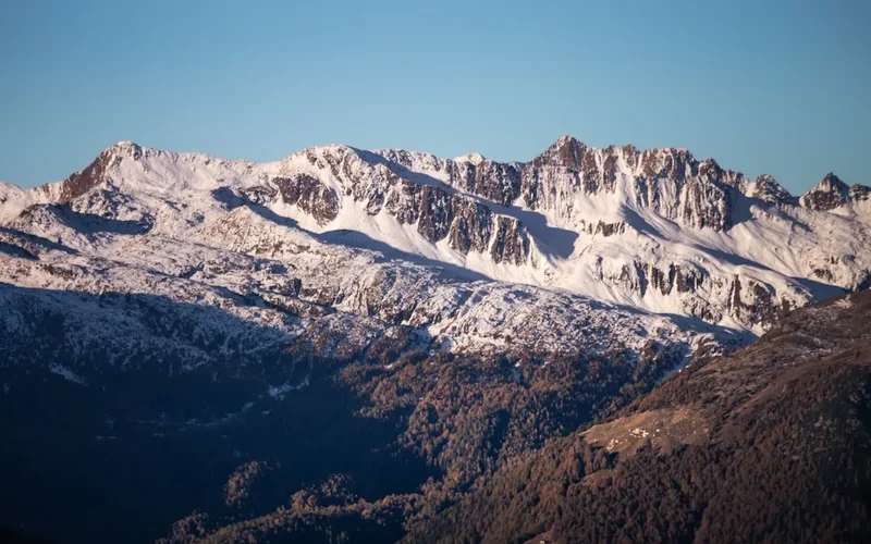
The Italian portion of the TMB is characterised by its rugged beauty, with steep ascents leading to panoramic viewpoints overlooking glaciers, snow-capped peaks, and verdant valleys. It winds through the Aosta Valley, a region steeped in history and natural splendour, offering a unique blend of challenging terrain and accessible beauty. This section is not merely a physical journey but a cultural immersion, allowing hikers to experience the distinct charm and traditions of Italian alpine life.
- Distance (Italian Section): Approximately 70.0 km
- Duration (Italian Section): 5–7 days
- Elevation Gain (Italian Section): Approximately 6,000 metres
- Difficulty: Challenging
- Best Time to Hike: July to September
- Closest Major Town: Courmayeur (Italy)
- Trailhead Access: Nearest major airport is Geneva (GVA). From Geneva, take a bus or train to Courmayeur. Driving: A5 motorway to Courmayeur. Parking is available but can be limited during peak season.
- Permits: No specific permits are required to hike the TMB, but mountain huts and refuges require advance booking.
- GPS Coordinates (Courmayeur): 45.79778, 6.96639
Overview
The Italian section of the Tour du Mont Blanc is a spectacular segment that showcases the raw, untamed beauty of the Alps. As hikers transition from France into Italy, the landscape often becomes more dramatic, with steeper ascents and more rugged terrain. The Aosta Valley, through which much of the Italian TMB passes, is a land of contrasts, featuring high alpine passes, vast glaciers, and fertile valleys dotted with ancient castles and picturesque villages.
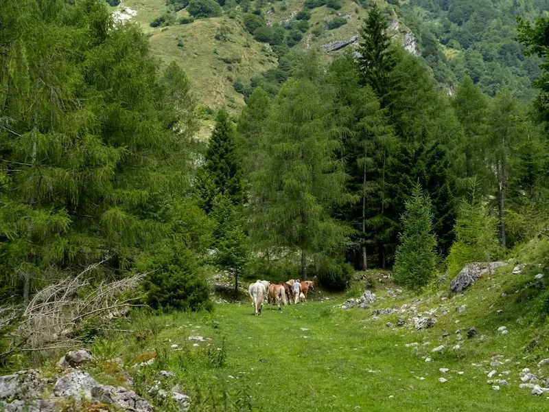
This section of the TMB is particularly noted for its challenging ascents and descents, which reward hikers with unparalleled vistas. The Val Ferret and Val Veny are key valleys within the Italian section, offering stunning views of the Mont Blanc massif's southern face. Hikers will encounter a variety of terrain, from well-maintained paths to rocky, scree-covered slopes, demanding good physical fitness and sure-footedness. The air is crisp, the scenery is immense, and the sense of accomplishment upon reaching each high pass is profound.
Beyond the natural beauty, the Italian TMB offers a rich cultural experience. The Aosta Valley has a unique Franco-Provençal heritage, evident in its language, architecture, and cuisine. Hikers can savour hearty mountain fare, including local cheeses, cured meats, and regional pasta dishes, often accompanied by excellent Italian wines. The hospitality found in the mountain refuges and villages is warm and inviting, providing a welcome respite after a day of strenuous hiking.
The Italian section is not a single, continuous trail but rather a series of interconnected paths and routes that form part of the larger TMB circuit. The exact route can vary slightly depending on chosen variations or specific accommodation bookings, but the core experience remains consistent: a challenging yet incredibly rewarding immersion in the heart of the Alps.
History and Cultural Context
The Mont Blanc massif has been a natural frontier and a source of fascination for centuries. Historically, the routes that now form the Tour du Mont Blanc were ancient pathways used by shepherds, traders, and pilgrims. These routes were vital for connecting communities across the high Alps, facilitating the exchange of goods and ideas between France, Italy, and Switzerland long before modern infrastructure existed.
The Aosta Valley, in particular, has a long and storied history. It was a strategically important region for the Romans, who built roads and settlements here, remnants of which can still be seen today. Later, it became a stronghold for various noble families, and numerous medieval castles and fortifications dot the landscape, testaments to its past importance. The valley's unique cultural identity is a blend of Italian, French, and Savoyard influences, with a distinct Franco-Provençal dialect still spoken by many locals.
The concept of a "tour" around Mont Blanc as a recreational activity gained traction in the late 19th and early 20th centuries with the rise of mountaineering and alpine tourism. Early explorers and adventurers began to map and popularise these routes, recognising their potential for challenging and scenic treks. The establishment of mountain huts and refuges over the decades has made the TMB more accessible, transforming ancient shepherd trails into a world-renowned hiking circuit.
Today, the TMB is a testament to the enduring appeal of the Alps, blending natural grandeur with a rich human history. The Italian section, with its dramatic landscapes and cultural heritage, offers a particularly compelling chapter in the story of this legendary trek.
Seasonal Highlights and Weather Reality
The hiking season for the Italian section of the Tour du Mont Blanc typically runs from July to September. During these months, the weather is generally most favourable for high-altitude trekking, with longer daylight hours and a higher probability of stable conditions.
July: This is often considered the start of the prime season. Wildflowers are in full bloom, carpeting the alpine meadows with vibrant colours. The snow has largely receded from the higher passes, making most routes accessible. However, July can also bring afternoon thunderstorms, a common feature of alpine weather, so starting hikes early in the day is advisable. Temperatures can range from cool in the mornings and evenings to pleasantly warm during the day.
August: This is peak season for many European hikers. The weather is typically warm, and the trails are busy. The landscapes are lush and green, and the mountain scenery is at its most majestic. As in July, afternoon thunderstorms are a possibility, and it's crucial to be prepared for rapid weather changes. August can also be a time of higher temperatures at lower altitudes.
September: This month offers a beautiful transition into autumn. The crowds begin to thin, and the air becomes crisper and clearer. The larch trees start to turn golden, adding a spectacular new dimension to the already stunning scenery. The weather can be more stable than in the summer months, with fewer thunderstorms, but early snowfalls are possible, especially later in the month at higher elevations. Temperatures will be cooler, and frost is more likely.
Weather Reality: It is crucial to understand that alpine weather is notoriously unpredictable. Even during the peak season, hikers can encounter rain, fog, strong winds, and even snow at higher altitudes. Temperatures can fluctuate significantly between day and night, and between the valleys and the mountain passes. Hypothermia is a real risk, even in summer, if hikers are caught unprepared in adverse conditions. Always check the mountain forecast before setting out each day and be prepared for all eventualities.
Recommended Itinerary
5-Day Tour du Mont Blanc (Italian Section) Itinerary
Day 1: Les Houches (France) to Rifugio G.F. Gonella (Italy)
- Distance: Approximately 15 km
- Elevation Gain: Approximately 1,500 m
- Time: 6–8 hours
- Start in Les Houches, France, and ascend towards the Col du Tricot.
- Cross the suspension bridge over the Glacier de Bionnassay.
- Descend into the Val Montjoie and then ascend towards the Col du Bonhomme.
- Continue to the Col des Fours (optional, higher pass) or traverse towards the Col du Bonhomme.
- Descend towards the Rifugio G.F. Gonella, a key refuge on the Italian side.
- This day involves significant ascent and descent, crossing into Italy via high passes.
Day 2: Rifugio G.F. Gonella to Rifugio Elisabetta Soldini Montanaro
- Distance: Approximately 12 km
- Elevation Gain: Approximately 800 m
- Elevation Loss: Approximately 700 m
- Time: 5–7 hours
- Descend from Rifugio G.F. Gonella towards the Italian side of the massif.
- The trail winds through alpine meadows and rocky terrain.
- Ascend towards the Col de la Seigne, a significant pass marking the border between France and Italy.
- Descend into the Val Veny on the Italian side.
- Arrive at Rifugio Elisabetta Soldini Montanaro, a picturesque refuge with stunning views of the Miage Glacier.
- This day offers dramatic views of the southern face of Mont Blanc.
Day 3: Rifugio Elisabetta Soldini Montanaro to Courmayeur (or nearby accommodation)
- Distance: Approximately 18 km
- Elevation Gain: Approximately 500 m
- Elevation Loss: Approximately 1,200 m
- Time: 5–7 hours
- Descend from Rifugio Elisabetta through the Val Veny.
- The trail follows the valley floor, passing through forests and small hamlets.
- Enjoy views of the glaciers and the imposing peaks surrounding the valley.
- Arrive in Courmayeur, a vibrant alpine town and a major hub for the TMB.
- Option to stay in Courmayeur or a nearby village for a rest day or resupply.
- This day offers a more relaxed descent into a significant Italian town.
Day 4: Courmayeur to Rifugio Bonatti
- Distance: Approximately 15 km
- Elevation Gain: Approximately 1,200 m
- Time: 6–8 hours
- Begin the ascent from Courmayeur into the Val Ferret.
- The trail climbs steeply, offering spectacular panoramic views of the Mont Blanc massif.
- Pass through alpine pastures and rocky sections.
- Arrive at Rifugio Bonatti, a renowned refuge perched high above the valley, offering some of the most iconic views of the TMB.
- This is a challenging but incredibly rewarding day with breathtaking scenery.
Day 5: Rifugio Bonatti to La Fouly (Switzerland)
- Distance: Approximately 10 km
- Elevation Gain: Approximately 400 m
- Elevation Loss: Approximately 1,000 m
- Time: 4–6 hours
- Descend from Rifugio Bonatti towards the Grand Col Ferret.
- Cross the Grand Col Ferret, the highest point on the TMB and the border between Italy and Switzerland.
- Descend into the Swiss Val Ferret.
- Arrive in La Fouly, a charming Swiss village, marking the end of the Italian section and the continuation into Switzerland.
- This day involves crossing another major pass and transitioning into a new country.
Important Notes:
- This itinerary is a suggestion and can be adapted based on fitness levels, accommodation availability, and personal preferences.
- Accommodation in mountain refuges (rifugi) must be booked well in advance, especially during peak season.
- The exact route can vary; consult detailed maps and guidebooks for specific trail options.
- Weather can change rapidly; always be prepared for adverse conditions.
- Carry sufficient water and food, as resupply points can be infrequent between refuges.
Planning and Bookings
Book Your Trip
Everything you need to plan your journey
Accommodation
Find places to stay near Courmayeur
Flights
Search flights to Courmayeur
Essential Preparation
Planning for the Italian section of the Tour du Mont Blanc requires careful consideration of logistics, fitness, and accommodation. The Aosta Valley offers a range of options, from high-alpine refuges to comfortable hotels in towns like Courmayeur. Given the challenging terrain and the multi-day nature of the trek, a good level of physical fitness is essential. This includes cardiovascular endurance for long ascents and descents, and strength for carrying a backpack over varied terrain.
Fitness: Aim to build up your stamina with regular hiking, including significant elevation changes. Practice hiking with a loaded backpack to get accustomed to the weight. Incorporate strength training for legs and core muscles.
Logistics: The nearest major international airport is Geneva (GVA). From Geneva, you can take a bus or train to Aosta, and then local transport to Courmayeur, which serves as a primary gateway to the Italian section. Alternatively, direct bus services from Geneva to Courmayeur are often available. If driving, the A5 motorway provides access to Courmayeur. Parking in Courmayeur can be challenging during peak season, so consider alternatives like public transport or pre-booked parking.
Base Town: Courmayeur is the main town in the Italian Val Veny and Val Ferret region and is an excellent base for starting or ending the Italian section of the TMB. It offers a wide range of accommodation, restaurants, shops for gear, and transport links. Other smaller villages like La Thuile or Pré-Saint-Didier can also serve as starting or ending points depending on your chosen itinerary.
Trail Accommodation
Accommodation along the Italian section of the TMB primarily consists of mountain refuges (rifugi) and some hotels or guesthouses in the valleys. Booking in advance is highly recommended, especially during the peak season (July to September).
Mountain Refuges (Rifugi):
- Booking Requirements: Essential to book well in advance, often months ahead for popular refuges during peak season. Reservations can usually be made online via refuge websites or through TMB booking platforms.
- Facilities Provided: Dormitory-style bunk beds (sleeping bags are usually required), communal dining areas, and often half-board (dinner and breakfast) options. Some refuges offer packed lunches. Basic toilet and washroom facilities are standard.
- What's NOT Provided: Towels, toiletries, sleeping bag liners (though some may rent them), cooking equipment (you are not permitted to cook your own food in refuges), and electricity for charging devices is often limited or unavailable.
- Seasonal Availability: Most refuges are open from mid-June to mid-September, depending on snow conditions and demand. Some may open earlier or close later.
- Costs: Prices vary but expect approximately €50-€80 per person per night for half-board.
Valley Accommodation (Courmayeur, La Thuile, etc.):
- Booking Requirements: Recommended to book in advance, especially in Courmayeur during summer.
- Facilities Provided: Hotels, B&Bs, and apartments offer private rooms, en-suite bathrooms, and often breakfast. Some may have restaurants.
- What's NOT Provided: Typically no communal dining for hikers unless it's a hotel restaurant.
- Seasonal Availability: Generally available year-round, but peak season prices apply in summer.
- Costs: Varies widely from €80-€200+ per night for a double room.
Camping: Wild camping is generally not permitted in national parks and protected areas, including much of the TMB route. Designated campsites may be available in some valley towns, but are not a common feature along the high-altitude sections of the trail.
Required Gear
- Sturdy Hiking Boots: Waterproof, broken-in hiking boots with good ankle support are crucial for navigating varied and often rocky terrain.
- Waterproof Jacket and Trousers: Essential for protection against rain and wind. Look for breathable, waterproof materials like Gore-Tex.
- Layered Clothing: A system of base layers (merino wool or synthetic), insulating mid-layers (fleece or down jacket), and an outer shell is vital for adapting to changing temperatures.
- Warm Hat and Gloves: Even in summer, temperatures at higher altitudes can drop significantly.
- Backpack: A comfortable backpack of 40-60 litres, with a good hip belt and rain cover.
- Head Torch: With spare batteries, for use in refuges and for early morning starts.
- First-Aid Kit: Including blister treatment, pain relievers, antiseptic wipes, bandages, and any personal medications.
- Navigation Tools: Detailed maps of the TMB route, a compass, and a GPS device or smartphone with offline maps.
- Sun Protection: High SPF sunscreen, sunglasses, and a wide-brimmed hat.
- Trekking Poles: Highly recommended for reducing strain on knees during descents and aiding balance on ascents.
What to Bring
- Food and Snacks: While refuges provide meals, carry high-energy snacks (nuts, dried fruit, energy bars) for during the day's hike.
- Water Bottles or Hydration Reservoir: Capacity for at least 1.5-2 litres.
- Water Purification Method: A filter or purification tablets are recommended, although water sources are generally plentiful and clean at higher altitudes.
- Toiletries: Biodegradable soap, toothbrush, toothpaste, hand sanitiser, and any personal hygiene items.
- Quick-Dry Towel: Lightweight and essential for use in refuges.
- Sleeping Bag Liner: Often mandatory in refuges for hygiene.
- Personal Items: Camera, power bank for electronics, book or journal, insect repellent (especially for lower altitudes and evenings).
- Cash: Some refuges may not accept credit cards, and it's useful for small purchases in villages.
- Duct Tape and Cord: Useful for emergency repairs to gear.
Permits
The Tour du Mont Blanc, including its Italian section, does not require specific hiking permits for general access. The trails are public rights-of-way, and you are free to hike them. However, the critical element for a successful trek is securing accommodation in the mountain refuges (rifugi) and valley hotels along the route.
Accommodation Bookings:
- Advance Booking is Essential: Due to the popularity of the TMB, especially during the peak season (July to September), all mountain refuges and many valley accommodations must be booked well in advance. Some refuges can book up months ahead.
- Booking Platforms: Many refuges have their own websites where you can book directly. Alternatively, several TMB-specific booking platforms and tour operators can assist with arranging accommodation packages.
- Flexibility: It is advisable to have a flexible itinerary and alternative accommodation options in mind, as popular refuges may be fully booked on your desired dates.
National Park Regulations: While no specific hiking permits are needed, hikers must adhere to the regulations of the national parks and protected areas they traverse. This typically includes rules regarding waste disposal, campfires, and respecting wildlife. Wild camping is generally prohibited in most areas along the TMB route.
Travel Insurance: It is highly recommended to have comprehensive travel insurance that covers trekking at altitude, potential medical emergencies, and evacuation. Ensure your policy covers activities like hiking and mountaineering.
Other Activities in the Area
The Aosta Valley and its surroundings offer a wealth of activities beyond hiking the TMB, making it an ideal destination for a longer stay:
- Mountaineering and Climbing: The Mont Blanc massif is a world-renowned centre for mountaineering. Guided ascents of Mont Blanc itself or other peaks are available for experienced climbers.
- Via Ferrata: The Aosta Valley boasts an excellent network of via ferratas (iron paths), offering a thrilling way to experience the mountains with fixed cables, ladders, and bridges.
- Skiing and Snowboarding: During the winter months, the region transforms into a premier ski destination, with resorts like Courmayeur, La Thuile, and Pila offering extensive slopes.
- Visiting Castles: The Aosta Valley is rich in history, with numerous well-preserved medieval castles, such as Forte di Bard, Castello di Fénis, and Castello di Sarre, offering a glimpse into the region's past.
- Thermal Baths: Relax and rejuvenate at the thermal spas in towns like Pré-Saint-Didier, known for their therapeutic waters and stunning mountain views.
- Gastronomic Tours: Explore the local cuisine with wine tastings, cheese farm visits, and cooking classes focusing on Aosta Valley specialities.
- Mountain Biking: Numerous trails cater to mountain bikers of all levels, from scenic valley routes to challenging downhill tracks.
- Paragliding: Experience the Alps from a bird's-eye view with tandem paragliding flights offering spectacular aerial perspectives.
Safety and Conditions
Weather: Alpine weather is highly unpredictable. Be prepared for rapid changes, including sudden storms, fog, strong winds, and temperature drops, even in summer. Always check the mountain forecast before setting out and be ready to alter your plans if conditions deteriorate.
Altitude: While the TMB does not reach extreme altitudes, some passes can be over 2,500 metres. Be aware of the symptoms of altitude sickness (headache, nausea, dizziness) and descend if symptoms worsen. Stay hydrated and acclimatise gradually.
Terrain: The trails vary from well-maintained paths to rocky, scree-covered, and sometimes steep sections. Good footwear with ankle support is essential. Trekking poles can significantly aid balance and reduce strain on joints.
Navigation: Carry detailed maps and a compass, and know how to use them. GPS devices or smartphone apps with offline maps are valuable tools, but should not be relied upon solely. Trails are generally well-marked, but visibility can be poor in fog or snow.
Water: Water sources are generally plentiful along the TMB, especially at higher altitudes. However, it is always advisable to treat water from streams and springs using a filter or purification tablets to avoid gastrointestinal issues.
Wildlife: While large predators are rare, be aware of local wildlife. Respect their space and do not feed animals. In some areas, you may encounter livestock (cows, sheep) on the trails; give them a wide berth.
Emergency Contacts: Know the emergency numbers for the region (112 in Europe). Consider carrying a personal locator beacon (PLB) or satellite messenger for remote areas where mobile phone reception is unreliable.
Refuge Safety: Follow the rules and guidelines provided by refuge wardens. Be mindful of noise levels, especially during sleeping hours. Ensure your sleeping bag liner is used for hygiene.
Physical Condition: Ensure you are physically fit for the demands of the trek. Undertaking the TMB without adequate preparation can lead to injury or exhaustion.
Side Trips and Points of Interest
Mont Blanc Ascent (Challenging): For experienced mountaineers with proper equipment and a guide, a summit attempt of Mont Blanc from the Italian side (via the Gouter or Bosses routes, often starting from Courmayeur) is a significant undertaking and a major highlight for some.
Val Ferret and Val Veny Exploration: Beyond the main TMB route, these valleys offer numerous opportunities for shorter hikes to viewpoints, glaciers, and alpine lakes. The trails are generally less crowded than the main TMB path.
Miage Glacier: Visible from Rifugio Elisabetta, the Miage Glacier is one of the largest glaciers on the southern side of Mont Blanc. Its dramatic, debris-covered appearance is a stark reminder of glacial power.
Col de la Seigne: This pass marks the border between France and Italy and offers spectacular panoramic views of the Mont Blanc massif, including the Dômes de Miage and the Aiguille Blanche de Peuterey.
Rifugio Bonatti Views: This refuge is famous for its unparalleled location, offering breathtaking, unobstructed views of the southern face of Mont Blanc and the surrounding peaks. It's a prime spot for photography and simply soaking in the alpine grandeur.
Grand Col Ferret: The highest point on the TMB, this pass offers a dramatic transition between Italy and Switzerland, with expansive views in both directions. It's a natural point for reflection on the journey so far.
Courmayeur Town: A charming alpine resort town with excellent amenities, including shops, restaurants, and historical sites. It's a great place to rest, resupply, and enjoy Italian hospitality.
Leave No Trace
The Tour du Mont Blanc traverses a fragile alpine environment that is shared by many. Adhering to Leave No Trace principles is paramount to preserving its beauty and ecological integrity for future generations.
Plan Ahead and Prepare: Research your route, understand the terrain, and be aware of local regulations. Pack appropriately for the conditions and carry sufficient food and water to minimise the need for resource use in the backcountry.
Travel and Camp on Durable Surfaces: Stick to marked trails to avoid damaging vegetation and causing erosion. When resting or taking breaks, do so on established paths or durable surfaces. Wild camping is generally not permitted; use designated campsites or book accommodation in refuges.
Dispose of Waste Properly: Pack out everything you pack in, including all food scraps, wrappers, and toilet paper. Use designated toilets in refuges and villages. If no facilities are available, dig a cathole at least 60 metres away from water sources, trails, and campsites.
Leave What You Find: Do not remove or disturb natural objects such as rocks, plants, or flowers. Respect historical and cultural sites.
Minimise Campfire Impacts: Campfires are generally prohibited in alpine areas due to the risk of wildfires and damage to vegetation. Use a portable stove for cooking.
Respect Wildlife: Observe wildlife from a distance and never feed animals. Feeding can alter their natural behaviour and diet, and can be harmful to their health.
Be Considerate of Other Visitors: Keep noise levels down, especially in refuges and natural areas. Yield to other hikers on narrow trails. Respect the peace and tranquility of the mountains.